Last updated: January 21, 2026
Article
Freshwater Salinization: Saltier Rivers Are a Growing Concern
By Dan Myers, Stroud Water Research Center

NPS/Kelsey Graczyk
Parks Protect Water Quality
Protected areas like national parks are critical places for conserving freshwater ecosystems. But even in parks, streams can still be vulnerable to degradation from human activities in the surrounding watersheds.
Today, freshwater salinization due to pollution from deicing salt runoff, sewage, and urban stormwater is degrading stream ecosystems throughout National Capital Region parks. Deicing salts (often sodium chloride) are applied to roads, parking lots, and other surfaces to keep them safe and reduce icy conditions.
Streams suffering from salinization often have degraded communities of fish and invertebrates with lower biodiversity where only pollution-tolerant species can survive. This negatively impacts the whole aquatic ecosystem. Aquatic critters such as mayflies (an important food for fish) are sensitive to pollution so are rare in salinized streams. For other organisms, too much salt causes their health to weaken and impairs their survival.
Still, parks have value for protecting streams from salinization, since streams with watersheds mostly contained inside of parks are faring much better than those with watersheds extending beyond park boundaries.
42,000 Tons of Salt a Year?!
Approximately 42,000 tons of deicing salt were applied in the watersheds of National Capital Region (NCR) park streams each year from 2005-2019, mostly outside of park boundaries.1 Applying deicing salt helps ensure that roads remain open and residents and visitors to the region can travel safely.
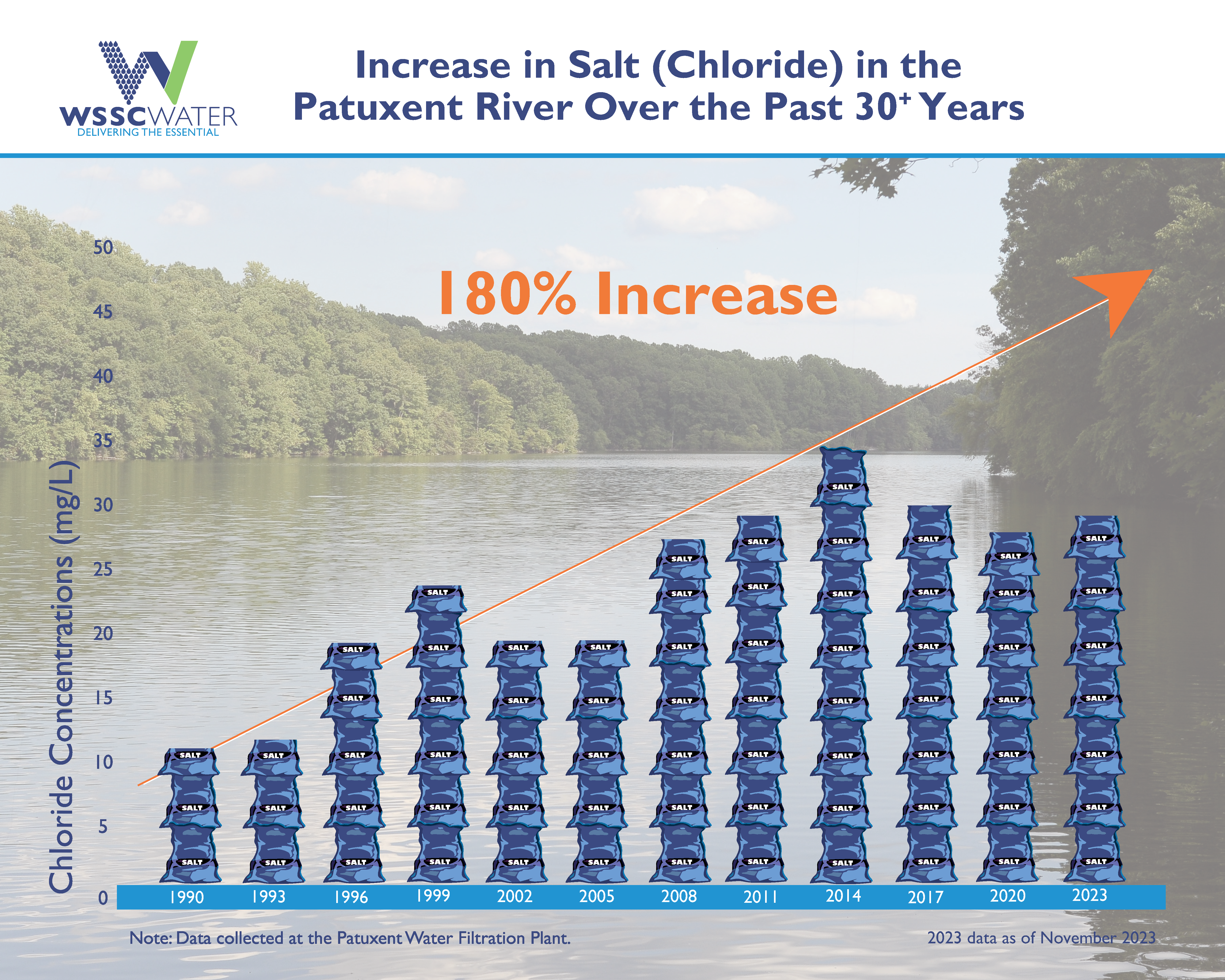
These streams flow primarily into the Potomac River which has seen chloride concentrations increase 104% from 1990 to 2023. A few flow into the Patuxent River which has seen chloride concentrations increase 180% from 1990 to 2023.

Stroud Water Research Center/ Myers
However, the salt applied to roads also moves as runoff into streams that flow through the region’s national parks. Park streams have been getting saltier over the last ~20 years, and some are as salty as nearby brackish estuaries, particularly after winter storms.2,3 This has implications for freshwater fish and other critters in the streams.4,5
The ability for water to conduct an electrical current, also known as specific conductance (SC), is a commonly-used indicator of stream salinity. In Maryland, the integrity of fish communities shows evidence of degradation when SC is over a tipping point of 171 μS/cm (microsiemens per centimeter).6

Stroud Water Research Center/ Myers
Antietam Battlefield = Antietam National Battlefield
Catoctin Mountain Park = Catoctin Mountain Park
George Washington Parkway = George Washington Memorial Parkway
Harpers Ferry = Harpers Ferry National Historical Park
Manassas Battlefield = Manassas National Battlefield Park
Monocacy Battlefield = Monocacy National Battlefield
National Capital Parks East = National Capital Parks - East
Prince William Forest = Prince William Forest Park
Rock Creek = Rock Creek Park
Wolf Trap = Wolf Trap National Park for the Performing Arts

National Wildlife Federation
Saltier Cities
By comparing the watersheds of park streams with different land uses, it’s clear that the causes for stream salinization are largely outside of park boundaries from upstream metropolitan areas with salt pollution from deicing, stormwater, and sewage. Monitored streams whose watersheds have 80-100% protected area typically have healthy SC levels for fish,6 while streams whose watersheds include 0-40% protected area have much higher SC. This demonstrates the value of the parks for protecting water from salinization for stream fish and invertebrates.

Stroud Water Research Center/ Myers
Parks Taking Action
Parks and surrounding communities are taking action to address salinization where feasible. Maryland and Virginia each have strategies to actively reduce salt pollution from treating roadways.7,8 And at the National Mall and Memorial Parks in Washington, DC, facilities staff use best practices including:

NPS
- using salt bin curtains and curbs to minimize runoff
- closely monitoring National Weather Service information
- strategizing with other nearby parks before storms to share resources
- calibrating equipment to prevent over-application
- pre-treating roadways with salt brine
- tracking all salt use to prevent over-application
Other best management practices to address stream salinity9 include:
- Using live-edge plows to enhance snow removal.
- Measuring and evaluate efficiency after each storm.
- Evaluating expectations for different service levels.
A RAD Framework for Addressing Salinization
As sources of salinization originate largely outside of parks, it is essential to collaborate with upstream communities to address salt pollution at its source. The Resist-Accept-Direct (RAD) framework is one approach to manage stream salinization in parks in collaboration with surrounding communities.

Stroud Water Research Center/ Myers
Learn More about the National Park Service's Inventory & Monitoring Efforts
To help protect natural resources ranging from bird populations to forest health to water quality, National Park Service scientists perform ecological Inventory & Monitoring (I&M) work in parks across the country. The National Capital Region Network, Inventory & Monitoring program (NCRN I&M) serves national parks in the greater Washington, DC area. To learn more about NCRN I&M stream water monitoring, you can visit the NCRN water monitoring webpage.
The NCRN has been partnering with the Stroud Water Research Center to develop data quality controls, update monitoring protocol, and analyze water quality data. This article is based on research published by Myers et al. in the journal Freshwater Science, "Freshwater salinization syndrome is degrading streamwater quality in the National Capital Region national parks, USA."
Further Reading
1. Bock, A. R., Falcone, J. A., & Oelsner, G. P. (2023). Estimates of road salt application across the conterminous United States, 1992–2019 (ver. 2.0, August 2023). US Geological Survey Data Release. https://doi.org/10.5066/P96IX385.
2. Norris, M. E., J. M. Pieper, T. M. Watts and A. Cattani. (2011). National Capital Region Network Inventory and Monitoring Program water chemistry and quantity monitoring protocol version 2.0: Water chemistry, nutrient dynamics, and surface water dynamics vital signs. Natural Resource Report NPS/NCRN/NRR—2011/423. National Park Service, Fort Collins, Colorado. https://irma.nps.gov/DataStore/Reference/Profile/2172524
3. Weaver, J., & Nortrup, M. (2016). NCRN Resource Brief: Specific Conductance in Streams. https://irma.nps.gov/DataStore/DownloadFile/554895
4. Kaushal, S. S., Likens, G. E., Pace, M. L., Utz, R. M., Haq, S., Gorman, J., & Grese, M. (2018). Freshwater salinization syndrome on a continental scale. Proceedings of the National Academy of Sciences of the United States of America, 115(4), E574–E583. https://doi.org/https://doi.org/10.1073/pnas.1711234115
5. Kaushal, S. S., Reimer, J. E., Mayer, P. M., Shatkay, R. R., Maas, C. M., Nguyen, W. D., Boger, W. L., Yaculak, A. M., Doody, T. R., Pennino, M. J., Bailey, N. W., Galella, J. G., Weingrad, A., Collison, D. C., Wood, K. L., Haq, S., Newcomer-Johnson, T. A., Duan, S., & Belt, K. T. (2022). Freshwater salinization syndrome alters retention and release of chemical cocktails along flowpaths: From stormwater management to urban streams. Freshwater Science, 41(3), 420–441. https://doi.org/10.1086/721469
6. Morgan, R. P., Kline, K. M., & Cushman, S. F. (2007). Relationships among nutrients, chloride and biological indices in urban Maryland streams. Urban Ecosystems, 10(2). https://doi.org/10.1007/s11252-006-0016-1
7. Bencala, K., Palmer, J., & Moltz, H. (2018). Salt management strategy: environmental impacts and potential economic costs and benefits of improved management practices in Northern Virginia. Interstate Commission on the Potomac River Basin (ICPRB), Virginia Department of Environmental Quality (DEQ). Available on: https://www.Potomacriver.org/Wp-Content/Uploads/2018/07/ICP18-3_Bencala.pdf.
8. MDOT. (2023). Maryland State Highway Administration Salt Management Plan. Maryland Department of Transportation. https://www.roads.maryland.gov/OOM/Statewide_Salt_Management_Plan.pdf
9. Hintz, W. D., Fay, L., & Relyea, R. A. (2022). Road salts, human safety, and the rising salinity of our fresh waters. In Frontiers in Ecology and the Environment (Vol. 20, Issue 1). https://doi.org/10.1002/fee.2433
10. Lynch, A. J., Thompson, L. M., Beever, E. A., Cole, D. N., Engman, A. C., Hawkins Hoffman, C., Jackson, S. T., Krabbenhoft, T. J., Lawrence, D. J., Limpinsel, D., Magill, R. T., Melvin, T. A., Morton, J. M., Newman, R. A., Peterson, J. O., Porath, M. T., Rahel, F. J., Schuurman, G. W., Sethi, S. A., & Wilkening, J. L. (2021). Managing for RADical ecosystem change: applying the Resist-Accept-Direct (RAD) framework. Frontiers in Ecology and the Environment, 19(8). https://doi.org/10.1002/fee.2377
11. Salt in water sources becoming worrisome in D.C. region, experts warn, by Antonio Olivo. August 8, 2022. https://www.washingtonpost.com/dc-md-va/2022/08/08/salt-sodium-water-levels-dc/
Tags
- antietam national battlefield
- catoctin mountain park
- george washington memorial parkway
- harpers ferry national historical park
- manassas national battlefield park
- monocacy national battlefield
- national capital parks-east
- prince william forest park
- rock creek park
- wolf trap national park for the performing arts
- ncrn
- ncrn im
- im
- water
- salinity
- stream
- road salt
- watershed
- freshwater
- brackish
- nature
- fish
- macroinvertebrate
- water monitoring
- specific conductance
- water quality