|
Colorado
A Classic Western Quarrel: A History of the Road Controversy at Colorado National Monument |

|
CHAPTER ONE:
The Landscape / The Setting (continued)
The Roots of Conflict 1881-1911
Prior to the arrival of white settlers, the Grand Valley was what historian Dave Fishell referred to as "one of the last, wild, unsettled frontiers in the lower forty-eight states." [25] Over the course of 500 years the area was the intermittent home to bands of Ute Indians who lived along the Grand Mesa, the Uncompahgre Plateau and the Bookcliffs. From the late eighteenth to the nineteenth century, the area served as a thoroughfare to a variety of explorers. Among the most famous of these were Fathers Dominguez and Escalante, who skirted the Grand Valley in 1776-77 on their unsuccessful trip from Santa Fe to a mission in Monterey, California. In the 1840s and 1850s, groups of army explorers, including John C. Fremont and Captain John Gunnison, made several trips through the Grand Valley while searching for an adequate mountain railroad course. In the 1870s, the government's Hayden and Wheeler survey groups explored and mapped the area. Their data was eventually compiled in the "Atlas of Colorado" complete with photos by William Henry Jackson. [26]
The Ute Indian removal of 1880 was instrumental in facilitating permanent white settlement in the Grand Valley. Additionally, the removal contributed to the incorporation of Grand Junction on September 26, 1881, by the Grand Junction Town Company. [27] The growth of mining and a series of treaties from 1863 to 1880 led to the removal of the Utes from the San Luis Valley to reservations in various portions of the Western Slope. When whites decided they needed more land, they pushed farther into the Western Slope. [28] Slogans such as "The Utes Must Go" and early newspaper headlines such as "The Utes are gone and the white man is here" reflected the general sentiment of white settlers, and fueled more interest in the area. [29] After the Meeker Massacre in 1879, which began when Utes murdered Indian Agent Nathan Meeker at the White River Agency, the removal of all Utes, including the Southern, White River, and Uncompahgre bands, was inevitable. By September 1881, the last of the Ute bands left the Western Slope via the Grand Valley. [30] Located at the confluence of the Colorado and Gunnison rivers, the Grand Valley attracted people even before it was open for settlement. In fact, even though the land ceded in the August 1880 treaty with the Utes would not be available for 10 months, within days of the treaty settlers poured into the area. [31]
|
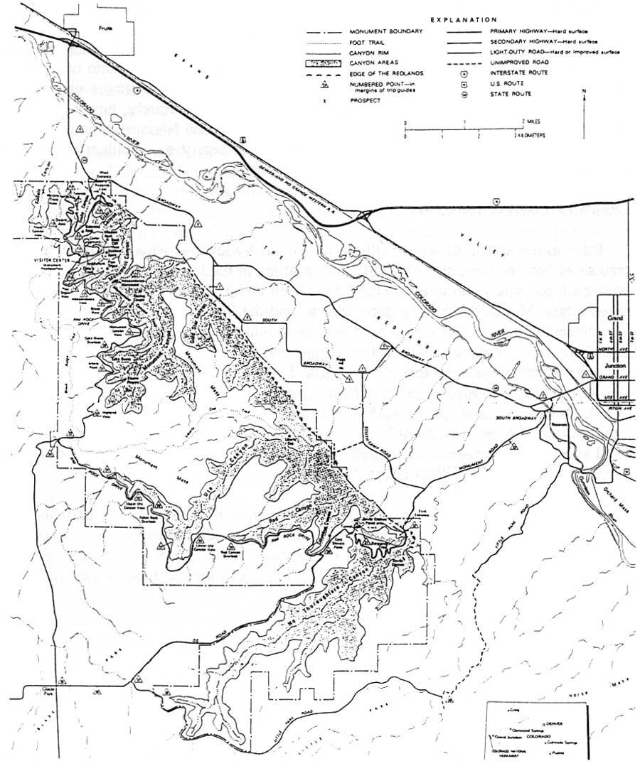
| Figure 1.1. Colorado National Monument and Surrounding Communities. From Stanley Lohman, The Geologic Story of Colorado National Monument (Washington, D.C.: Government Printing Office, 1981). (click on image for an enlargement in a new window) |
Land use conflicts involving Colorado National Monument originated in 1881, when whites first settled the Grand Valley. Early in their development the communities of Grand Junction, Glade Park, and Fruita grew accustomed to unrestricted use of the area that would become Colorado National Monument. Sandwiched between the Grand Valley and Glade Park, the Monument served as a natural thoroughfare for these three communities. [32]
The early growth of Grand Junction was remarkable. Only four years after the Ute removal, more than 850 people resided in Grand Junction, where seventy businesses, five churches, and many voluntary groups already existed. [33] In 1882, work began on irrigation canals in the Valley. [34] The Pioneer Ditch and the Pacific Slope Ditch provided water for both agricultural and household use. The Denver and Rio Grande Railroad arrived in 1882, and the Midland Railroad in 1890. Both were instrumental in promoting the town through the transportation of settlers and goods, "providing jobs," and making Grand Junction an important commercial center. [35] Between 1883 and 1900, the number of businesses in Grand Junction tripled. [36] In addition to publishing three newspapers by 1884, Grand Junction also had a volunteer fire department and numerous other public services. [37]
|
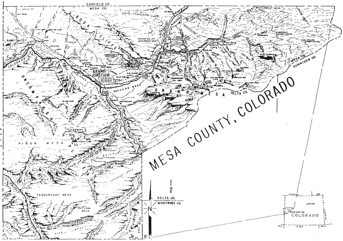
| Figure 1.2. Topography of Mesa County, Colorado. From Emma McCreanor, Mesa County, Colorado: A 100 Year History 1883-1983, edited by Lani Duke (Grand Junction: Museum of Western Colorado Press, 1986). (click on image for an enlargement in a new window) |
The rise of the fruit and sugar industries sparked potential residents' interest in the community. In 1883, Elam Blaine introduced fruit trees to the Grand Valley. Highly adaptable to the climate and irrigation, peach and apple trees produced profitable cash crops. Orchards quickly spread across the valley. [38] Publicity linked to the fruit industry, such as annual "Peach Days" was easily marketed on a national level. The sugar industry started when the state's first sugar factory was built in Grand Junction by the Colorado Sugar Manufacturing Company at the turn of the century. Soon sugar beet fields dotted the Grand Valley. [39]
An important element in the early growth of the Grand Valley, and more specifically, Grand Junction, was the work of boosters in promoting the area. After it was established in 1903, the Grand Junction Chamber of Commerce waged a campaign to promote the Grand Valley, emphasizing everything from the area's agricultural potential to the quality of Grand Junction's citizens. A booklet entitled "Valley of the Grand: The Place for You," issued by the chamber after 1906 exaggerated about the area's climate, fruit industry, and social institutions. For instance, the Grand Valley was the "garden spot of the country," the fruit "unequalled," the climate "without extremes of temperatures." [40] In addition, it had "a good society, its citizenship being made up of intelligent, sociable progressive people from the East and Central West." [41]
Toward the end of 1906, the promotional campaign entered a new phase. Once centered on attracting settlers, the campaign eventually focused on tourism. Efforts to establish the "Monument National Park" out of the canyons of the Colorado Plateau running along the valley's southern edge characterized this trend. At first, descriptions of the area highlighted Monument Canyon. A booklet distributed by the Fruita Bureau of Information stated that "for a more general outing place, Monument Cañon, Fruita Park, Devil's Cañon etc. all within two hours ride, afford places of recreation and scenes of grandeur, rivaling the "'Garden of the Gods'" [42] Photographs of the Monument in this booklet were captioned with phrases such as "scenes from Monument Cañon" and "Nature Freak Near Fruita," describing what is now known as the "Kissing Couple" monolith in Monument Canyon. [43] Even then, descriptions of Monument Canyon emphasized its unusual landscape. The fact that it was part of the promotional literature for both Grand Junction and Fruita indicated that the community realized its potential as a tourist attraction. Public awareness fostered a local campaign to have the area set aside as a national park. The Grand Junction Chamber of Commerce developed a vested interest in the creation of the Colorado National Monument that cultivated its almost "proprietary attitude" toward the park's establishment, and later its administration. [44]
Glade Park was another community with interests in the Monument prior to its creation. Early ranchers at Glade Park enjoyed squatters' rights in the Colorado National Monument region. A vast mesa located west and south of Grand Junction above the Colorado National Monument, Glade Park was divided into seven sections prior to 1910: Glade Park, Little Park, Piñon Mesa, West End, Beezer Creek, Coates Creek and Little Dolores. [45] Between 1883 and 1910, the proliferation of cattle and sheep ranches, and dry farms at Glade Park led to permanent settlement of the region.
Cattle ranching commenced in 1883 when C.W. Sleeper and Wendell Ela, both originally from New Hampshire, organized the 2V Ranch on the Little Dolores Creek. They raised 6,000 head of cattle there. In 1885, Charles Sieber settled in Glade Park. He brought in 10,000 head of cattle and started a retail meat market business in Grand Junction. Sieber drove 8,000 head of cattle from Kansas and Texas to Glade Park in 1888. In 1897, he organized the Sieber Cattle Company. By this time, Sieber had begun buying ranches along the Little Dolores, Coats Creek and Piñon Mesa. Before he was shot from his horse over a branding dispute in 1902, Sieber ran 30,000 bead of cattle from the Sieber Cattle Company. [46]
Ranches flourished throughout the late 1880s and 1890s. Settlers poured into the region, hoping to try their luck raising cattle. Most of the Grand Valley was an ideal area for winter range, while the plateaus of Glade Park provided good summer range, so cattlemen began looking for ways to transport their livestock to the Grand Valley. [47] Until 1908, Glade Park was primarily "cattle country," as evidenced by the following from a history compiled by one of Glade Park's early settlers:
There were very few fences. Everyone's cattle went where they pleased, in the summer on Piñon Mesa, and all over the area known as Glade Park. In the winter they were pushed down on the benches toward the river. [48]
Although ranchers had sheep prior to this time, widespread sheep ranching began around 1908, when 40,000 sheep from the Goslin Sheep Company traversed a bridge over the Grand River from Utah and moved into the Glade Park region. [49] The conflict between sheep and cattle ranchers was especially troublesome in Glade Park from 1903 to 1915. Cattlemen believed that sheep ruined the range and the water, and that their odor repulsed the cattle. A likely reason for the disagreements between sheep and cattle owners, however, was the competition for good grazing lands. It is not exactly clear what started the problems in Glade Park, but by 1903 cattlemen had initiated a series of violent attacks on sheepmen. In that year, Glade Park cattlemen drove 100 head of sheep off a cliff in Piñon Mesa, and two years later, in 1905, a $1500 bounty was raised to kill a local sheepman. The plan failed when only $1000 was raised. The violence finally diminished after 1915, when Mrs. Nancy Irving's Angora goats were driven off a rim of No Thoroughfare Canyon. Violence was not unusual in Glade Park. In fact, the area often served as a hideout for "outlaws." Glade Park ranchers were frequently victimized by John Dalley, a train robber and cattle rustler, who continued his crimes until the start of World War I. [50]
Dry farmers faced a less perilous reception from cattlemen, but their attempts to grow produce on Glade Park were far from successful. Corn, small grains, wheat, rye, and potatoes were the primary crops. Most farmers sold their produce in Grand Junction. [51] In 1907, Charles DuVall built the first dry farming homestead. After the Glade Park post office opened in 1910, more families moved into the region to try dry farming. Because dry farmers were at the mercy of the weather, they rarely experienced consistent success with crops. Typically settlers shifted between dry farming and cattle ranching, hoping to find some sort of economic security. [52]
Glade Park's development reached a turning point in 1912, when the first schools were established. Because parents paid for their children to attend, these early educational facilities were known as "subscription schools." In 1912, seven schools, one for each section of Glade Park, accepted students. Even though only three pupils were needed to maintain a school, the institutions indicated that the Glade Park area had become a permanent community despite its isolation from the Grand Valley. Originally, the only roads were foot trails that were nearly impassible in bad weather. Even in good weather, the trip from the Little Dolores region of Glade Park down to the Valley required an entire day. [53] With the demand for roads on which to transport stock to winter range, and the need for farmers and settlers to travel to Grand Junction, better roads became a necessity.
Long before the Colorado National Monument was established, Glade Park ranchers used parts of that area to access the Grand Valley. The first roads from Glade Park to Grand Junction led through the eastern end of what is now the Colorado National Monument. In 1883, Mesa County initiated the construction of a road from Grand Junction to East Creek Divide on Glade Park. A road petition submitted to the Mesa County Commissioners by local residents, requested construction of a "public highway or road" between these two termini. As a result, the County Commissioners appointed J.M. Russell, C.C. Hammond, and Charles F. Shanks to view the proposed road site. [54] The campaign for this road lasted into 1884. In his report to the County Commissioners in January 1884, Deputy County Engineer J.D. Robinson described the route "from the terminus of the present 'county road' on the west side of the Grand River in a southern direction to point on the north side of the 'East Creek Divide.'" [55] Robinson noted that "the greater portion of this route has already been opened for travel," but that it needed refinement. [56] His report also included a map of the route that eventually became Little Park Road. Skirting the eastern edge of the Monument, Little Park Road was one of several roads from Glade Park to the Grand Valley.
Other lesser quality roads and trails crisscrossed the region as well. Gordon's Toll Road came up through Little Park behind where the east entrance of the Colorado National Monument is today. [57] When ranchers complained that the toll was too high given the road's poor, they surveyed their own route. This led through "Deer Pass," which was a trail used by deer ascending through the rim rocks. [58] Another road, known as Jacob's Ladder, extended from Little Park to Piñon Mesa by way of Monument Springs. [59] The Billy Goat Trail ascended the entrance to No Thoroughfare Canyon near the present start of Rim Rock Drive. [60] On the other end of the valley, near the present site of the west entrance of Colorado National Monument, a road known as the Fruita Dugway was built. It stretched from Fruita through Fruita Canyon, toward Glade Park. The Fruita Dugway was built during the 1907 construction of the Fruita Water Pipeline, which delivered water from reservoirs on Piñon Mesa to the city of Fruita. [61] Both Glade Park and Grand Valley ranchers used the Dugway to drive their cattle to and from summer and winter range on Glade Park and the Valley. [62]
Another community in close proximity to the Colorado National Monument is Fruita. Its interests in the land of the Colorado National Monument were also quite apparent prior to the park's establishment. Located on the main line of the Denver and Rio Grande Railroad, Fruita lies 12 miles west of Grand Junction. William E. Pabor established the town in May 1884. Shortly thereafter, he formed the Fruita Town and Land Company, which purchased 520 acres of land and enough water rights to irrigate the tract. By 1886, five-acre plots of this tract were sold for $500. [63] Fruita continued its growth throughout the early 1900s. A variety of advancements contributed to this growth. The first school was organized in 1884, the first telephone used in 1900, and electricity came to Fruita in 1910. [64]
Fruita was an agricultural community where diversified farming with potatoes, sugar beets, and winter wheat was common, but fruit was the most profitable crop. Pabor believed the soil around Fruita was ideal for fruit growing, and as early as 1883, he planted orchards in the Lower Valley (Fruita's location in the Grand Valley). Apples were particularly successful, although other fruit crops were grown. By 1910, Fruita shipped its crops by rail to various markets outside the Grand Valley. [65] Difficulties with irrigation and coddling moths led to the decline of the fruit industry, which nonetheless remained central to the economy of the Grand Valley until around 1911. [66]
Until 1907 Fruita did not have an efficient water system. Water was hauled from the river or from nearby irrigation ditches, presenting the danger of using contaminated waters. As a result, the Fruita and Redlands districts decided to construct a pipeline from the "Fruita Forest Reserve" on Piñon Mesa where there were several reservoirs. [67] In February, 1906, the Fruita Forest Reserve was established by presidential proclamation. Located approximately 20 miles south of Fruita, this area promised to provide ample supplies of water for municipal use. [68] The construction of the pipe, however, proved difficult. There were 23 miles of "mountains and precipitous cliffs," including what is now Colorado National Monument, between Piñon Mesa and Fruita. [69] Pipe had to be hauled from the railroad in Fruita, across the river by ferry, and up to Fruita Canyon. The Fruita Dugway, which had served as a stock driveway since the 1880s, was blasted out of rock and built up through this canyon to accommodate lifting 40-50-carloads of pipe from the valley over the canyon walls. The Fruita bridge, which crosses the Colorado River, was also built in 1906 to facilitate the transportation of construction materials. In 1907, the pipeline was completed. [70] The wooden pipe, known as the Fruita aqueduct, stretched from the reservoirs on Piñon Mesa, down to the Glade Park cutoff, through the present park campground. Eventually it terminated in the reservoir at the base of the Colorado National Monument via Fruita Canyon. [71] Water was obtained from two 20-million-gallon reservoirs in the Fruita Reserve and one smaller reservoir in Fruita Canyon. Thirty years after its construction, the system delivered 750,000 gallons of water in 24 hours. [72]
The water pipeline linked Fruita to the Colorado National Monument. After the park's establishment, the presence of the pipeline formed an association be Fruita and officials of the National Park Service. During the depression, when Rim Rock Drive was built through the park, the pipeline supplied water to the CCC camps. In addition, National Park Service camps were supplied with 10 percent of the flow in return for replacing the original wooden water line with cast iron pipes. [73]
The development of these three communities—Fruita, Grand Junction, and Glade Park—reveals that interest in, and use of, the Monument had already surfaced by the time the park was officially established. Adjacent community use of the area created a framework for a relationship with the National Park Service that from 1911 to 1986 became increasingly conflictive. Park Service conflicts with local residents are not unusual. As John C. Freemuth points out in his book Islands Under Siege, today's national parks have been confronted with the threat of adjacent land activity for many years. On the other hand, adjacent landowners often see the parks as threats to their freedom. Relations between officials of the Colorado National Monument and its adjacent communities reflected a combination of these two perceptions. Prior to the park's establishment, however, there was no Park Service, so the community's perception was that the land was there to be used. The establishment of the Colorado National Monument transformed and restricted these uses indefinitely. Over the years, the expectations of local communities and the willingness of the National Park Service to meet those expectations became problematic.
| <<< Previous | <<< Contents >>> | Next >>> |
colm/adhi/adhi1-1a.htm
Last Updated: 09-Feb-2005