Part of a series of articles titled NCBN Yearly Status Reports | Estuaries.
Article
2021 Estuarine Nutrient Enrichment Status Report: Fire Island NS
Site Context
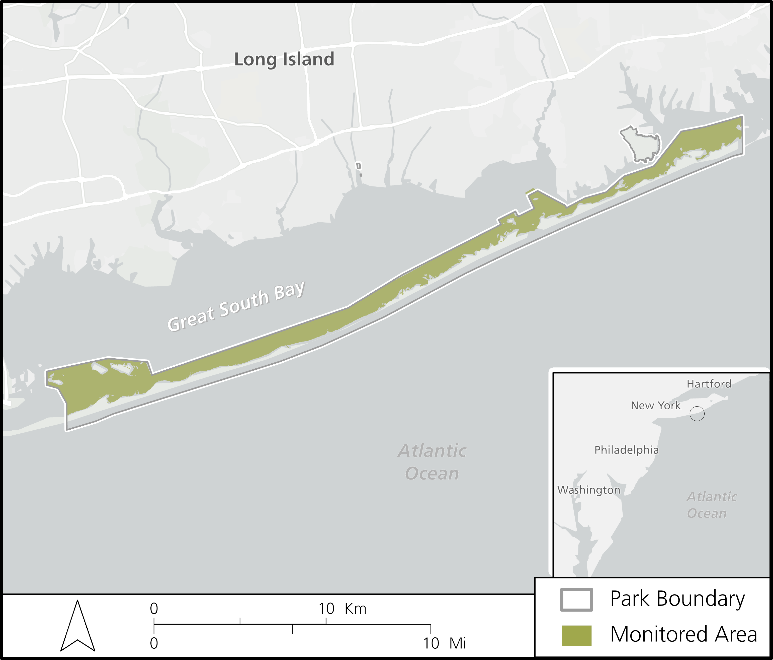
Fire Island National Seashore (FIIS) is a 7,810 ha park on the South Shore of Long Island, New York (Fig. 1). Approximately 46% of this area is submerged estuarine land in Great South Bay and Moriches Bay. Although FIIS owns only a minority portion of the submerged land in these bays, the area in park ownership is, nonetheless, extensive.
The threat of nutrient enrichment is a primary management concern. Water quality monitoring follows Northeast Coastal and Barrier Network’s Protocol for Monitoring Estuarine Nutrient Enrichment (Kopp and Neckles, 2009). The protocol’s primary goal is to assess how estuarine natural resources are affected by changing nutrient inputs by determining the status and trends of response indicators within the monitored estuarine areas of each park.
Presented here are condition status summaries of three key response indicators:
1) bottom water dissolved oxygen (DO)
2) surface water chlorophyll-a
3) water column light attenuation (Kd)
Threshold values are used to determine “good”, “fair”, and “poor” condition categories (Table 1), which are consistent with those used by the US Environmental Protection Agency (USEPA) for national coastal condition reporting (USEPA 2001b, 2004) and thresholds used by National Oceanic and Atmospheric Association for the National Estuarine Eutrophication Assessment (Bricker et al. 1999).
Water clarity is expressed as Kd (m-1). Cutoff values of Kd have been calculated from the USEPA criteria for turbidity, using the thresholds for areas with significant submerged aquatic vegetation (SAV).
| Measure | Good | Fair | Poor |
|---|---|---|---|
| Chlorophyll-a | < 5 µg/L | 5-20 µg/L | > 20 µg/L |
| Dissolved oxygen | > 5 mg/L | 2-5 mg/L | < 2 mg/L |
| Light attenuation | < 0.92 m-1 | 0.92-1.61 m-1 | > 1.61 m-1 |
Bottom Water Dissolved Oxygen
Bottom water DO concentration is an indirect indicator of nutrient load and direct indicator of estuarine water chemistry and organism health. Oxygen is consumed when microbial decomposers mineralize organic matter on and within estuarine sediments. When sediment organic matter increases due to nutrient over-enrichment it can cause an overgrowth of nuisance algae. The resulting heightened microbial decomposition can lower DO concentrations in bottom waters. It can also lead to increased extent and duration of bottom water anoxia and toxic sulfide concentrations. Nutrient enrichment can, ultimately, impact fauna diversity and abundance and shift species dominance.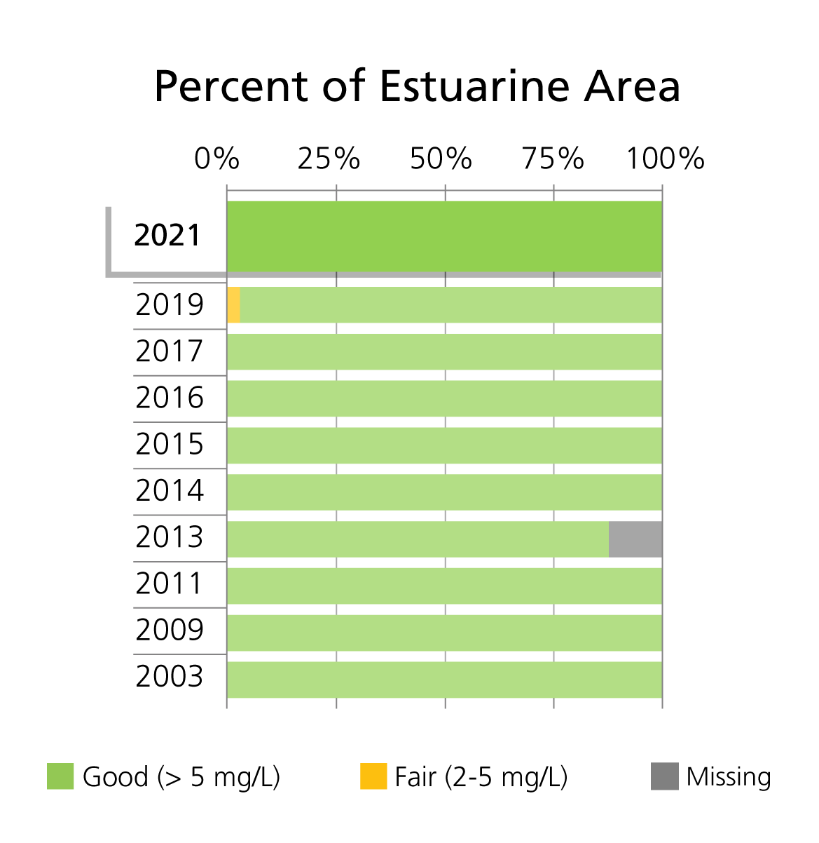
Surface Water Chlorophyll-a
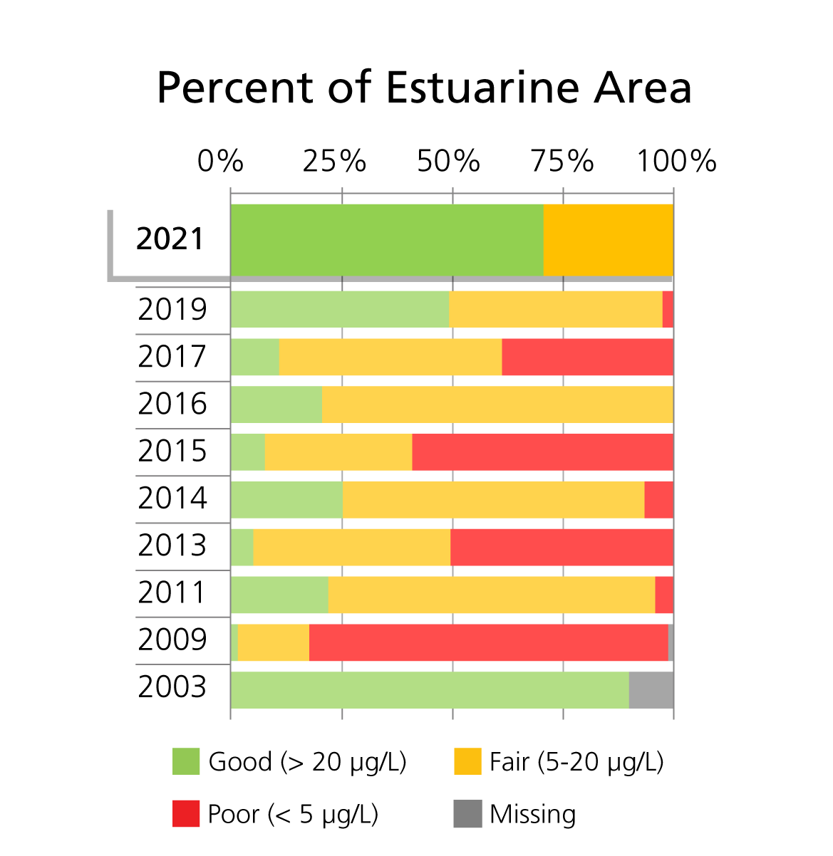
Nutrient enrichment often stimulates phytoplankton production, leading to population growth. Phytoplankton growth is often nutrient-limited. Trends of increasing biomass can suggest increasing nutrient load. Surface water chlorophyll-a concentration is an indicator of phytoplankton population growth, nutrient enrichment, and overall water quality.
Water Column Light Attenuation
Submerged aquatic vegetation (SAV) provide important ecosystem services. SAV productivity and distribution depend on light. Light attenuation through the water column is dependent on concentrations of phytoplankton, which can correlate with nutrient enrichment, and suspended inorganic and dissolved organic matter. Regardless of current SAV presence, NCBN continues to monitor this critical SAV parameter, as it provides information relevant to the overall estuarine eutrophication status.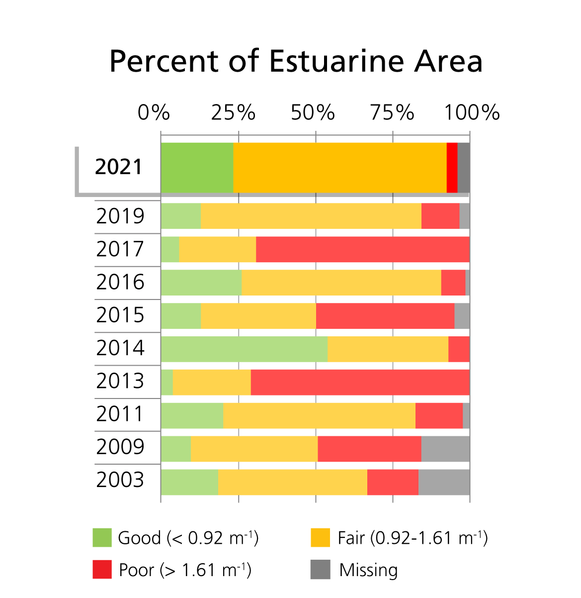
Conclusion
In 2021, Fire Island National Seashore saw varying conditions of bottom water dissolved oxygen, surface water chlorophyll-a, and water column light attenuation (Kd). There was a slight improvement in all three response variable compared to the previous several years.The majority of sampled estuarine area was in good condition for both bottom dissolved oxygen and surface water chlorophyll-a concentration. Historically, bottom water dissolved oxygen levels have been good for all of the estuarine area in the FIIS sample system, except for in 2019, with a slight increase in fair condition percentage. In terms of water column light attenuation (Kd), the majority of the area was in fair condition, which was consistent with historical observations.
Conditions of these three status indicators at Fire Island National Seashore in 2021 indicate that the estuary continues to experience estuarine nutrient over-enrichment.
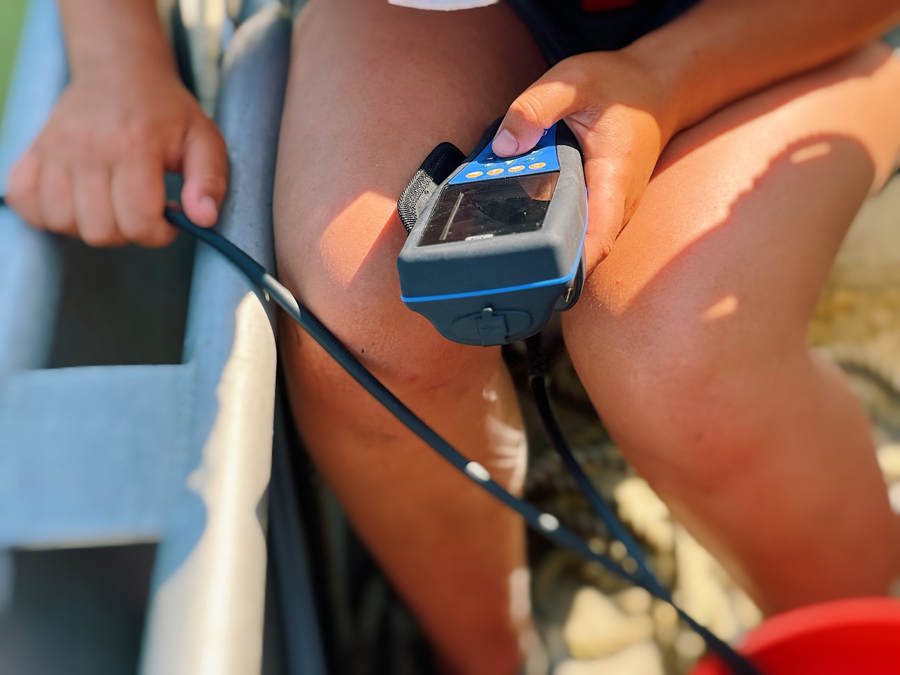
NPS Photo / Michaela Compo
References
Kopp, B. S. and H.A. Neckles. 2009. A Protocol for Monitoring Estuarine Nutrient Enrichment in Coastal Parks of the National Park Service Northeast Region. Natural Resource Report NPS/NCBN/NRR—2009/110. National Park Service, Fort Collins, Colorado.
U.S. EPA. 2001. National coastal assessment: field operations manual. U.S. Environmental Protection Agency, Office of Research and Development, National Health and Environmental Effects Research Laboratory, Gulf Ecology Division, Gulf Breeze, FL. EPA 620/R-01/003.
U.S. EPA: 2003. Ambient Water Quality Criteria for Dissolved Oxygen, Water Clarity and Chlorophyll a for the Chesapeake Bay and Its Tidal Tributaries, EPA-903/R-03/002, United States Environmental Protection Agency, Region III Chesapeake Bay Program Office, Annapolis, MD; Region III Water Protection Div., Philadelphia, PA, and Office Water, Office of Science and Technology, Washington, D.C.
Last updated: September 10, 2024
