Last updated: January 20, 2021
Article
After the Andrew Creek Fire
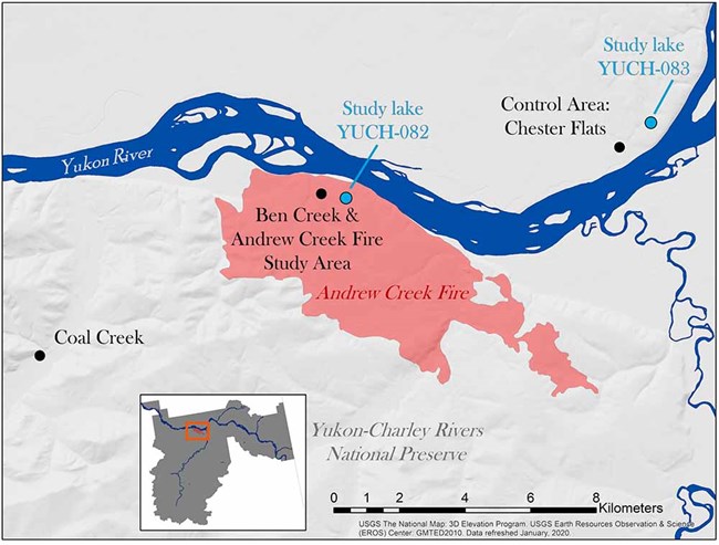
In 2018, a lightning strike ignited a fire that burned 31.8 km2 in Yukon-Charley Rivers National Preserve. The Andrew Creek Fire (Figure 1) is just one of many fires that have burned in the preserve over the past 50 years.
Unlike other fires, this one burned a mixed forest underlain with yedoma, an organic-rich Pleistocene-age permafrost with high ice content (50-90%). Yedoma is common in Siberia and other arctic regions, but only small patches still exist in interior Alaska; approximately 515 km2 and 229 km2 remain in Yukon-Charley and Denali National Park and Preserve, respectively. Yedoma is sensitive to environmental disturbances such as fire because the ground ice is protected by the overlying organic material. When the organic layer is disturbed, ground subsidence and erosion commonly occur as the frozen soil thaws.
Cold, acidic, and wet soils are characteristic of boreal forests underlain with shallow permafrost. These sites are characterized by soil that has a thick layer of organic material (peat) which accumulates because of slow rates of decomposition. This organic horizon profoundly affects factors that influence plant growth including soil temperature, acidity, and moisture. During fires, the organic layer can be partially or wholly consumed, changing soil conditions. Changes to the depth or character of the organic layer represents one of the most significant impacts of fire on ecosystems in interior Alaska and, depending on severity, may initiate far-reaching consequences to ecosystem development such as permafrost thaw and degradation and shifts in plant species assemblages and productivity.
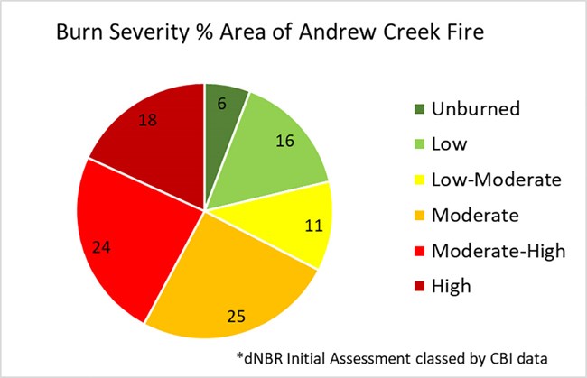
Burn severity influences the degree of organic layer consumption and the above-ground biomass changes that result from a fire. Severity affects plant succession, recovery, and ground insulation by changing the depth of the organic layer. In arctic and boreal systems, organic layer depth influences soil temperatures and the rate of permafrost thaw; all of these changes can influence soil stabilization and aquatic systems. Fire ecologists Jennifer Barnes and Jennifer Hrobak utilized remote sensed burn severity maps to characterize the burn severity of the fire area. These maps provide landscape-level burn severity effects. In 2019 field crews revisited the fire to ground truth the Landsat remote sensed dNBR burn severity maps1 and provide general burn severity information at a plot level. Based on the initial assessment of the dNBR burn severity map, a mosaic of burn severity occurred at the fire which is common in landscape level fires in Alaska: 42% of the Andrew Creek Fire area had moderate-high to high burn severity, 11 % moderate and 27% low to low-moderate and 6% unburned inclusions (Figure 2). The level of moderate to high burn severity is within a normal range for fires in Alaska, but the area near the long-term monitoring plots and study sites had more moderate to high severity area. In addition to landscape level burn severity, microscale burn severity is important to measure to determine impacts to the organic soil layers in these boreal systems.
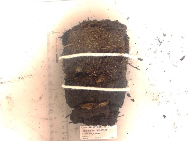
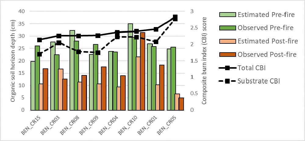
Plant ecologist Carl Roland and botanists Fleur Nicklen and Sarah Stehn have been studying microscale burn effects on the organic surface horizon (OSH) in long-term vegetation monitoring plots (Figure 3). In 2008 (pre-fire), they visited one of their field sites, Ben Creek, which is located within what would become the Andrew Creek Fire area. When the site burned, the crew, along with fire ecologists Jennifer Barnes and Jennifer Hrobak, returned to the site to capture post-fire effects. Using both field measurements and calculated estimates, they found that, on average, between 10 and 15 cm of OSH were lost across the study area during the Andrew Creek fire, with localized consumption of OSH of more than 20-cm occurring (Figure 4). Using the composite burn index (CBI), which ranks fire severity on a scale from 0-3 based on impacts to substrate and vegetation2, they scored each plot to capture the local diversity in ecological fire effects. The results showed that burn severity was not uniform and areas with significant organic material persisted within the fire perimeter.
These fire-induced effects are expected to cause important changes in soil condition and plant habitat including diminished water holding capacity and warmer soils. Vegetation within areas of persisting organic material will be more resilient to changes in plant species composition, as surviving seeds and roots begin re-growing quickly. In areas with little to no remaining organic material, pre-fire conifer-dominated vegetation will likely shift to broadleaf-dominated vegetation, a change in species composition that frequently follows high severity fire events that consume a majority of the soil OSH in northern boreal forests.
The loss of organic matter has led to accelerated permafrost decay and ground subsidence throughout the study area. In September 2020, physical scientist Ken Hill and terrestrial ecologist Dave Swanson established new permafrost monitoring sites at the Andrew Creek Fire, Coal Creek, and Chester Flats. Average active layer thickness (thaw depth to permafrost) at the Andrew Creek Fire grid was 81 cm vs. 49 cm at the unburned Chester Flats grid (50m x 50m grids; n=121 points). Botanist Fleur Nicklen reported that the difference that Hill and Swanson found between the burned and unburned sites was proportional to the difference in pre-fire (2008) and post-fire (2019) active layer thickness within the Andrew Creek Fire area, suggesting that active layer thickness has increased substantially since the fire. Hill and Swanson also conducted a baseline elevation survey which will allow the park to continue monitoring ground subsidence.
NPS/Danielle Knapp
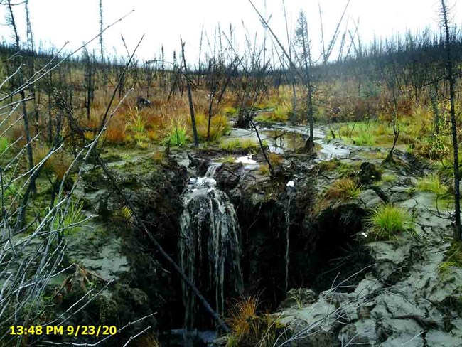
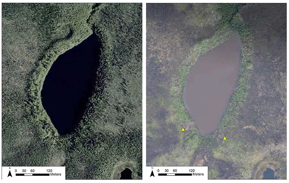
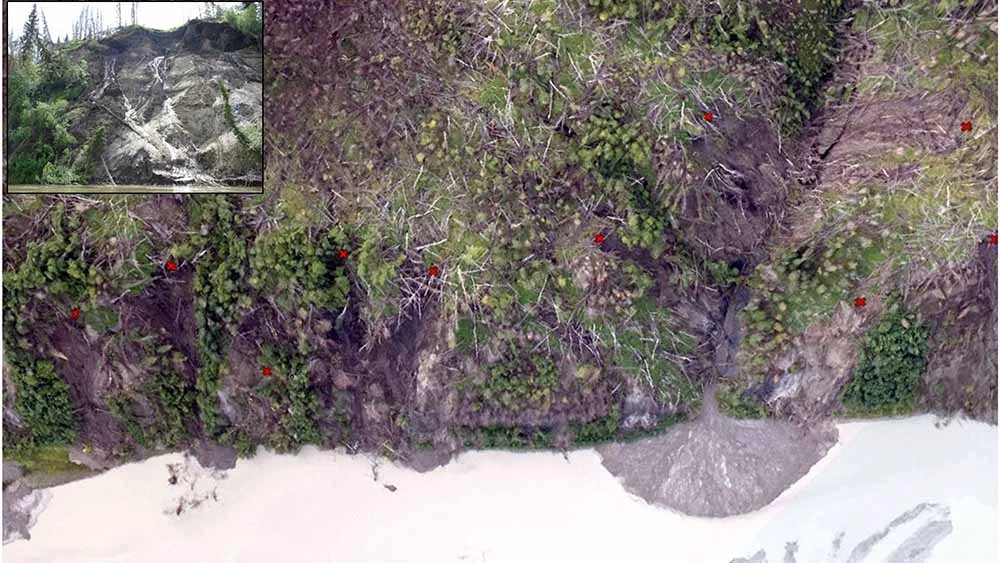
Park scientists are also tracking ground subsidence within the fire perimeter using a technique called structure from motion (SfM). This technique allows scientists to see small changes in surface topography over time. Chad Hults, a NPS geologist, has been leading this effort, and has documented 126 landslides within the fire perimeter and 78 along the Yukon River to date. He has also identified 22 landslides along creeks/gullies (Figure 5), 5 gully erosions, 12 deteriorating lake shorelines (Figure 6), and 12 areas where significant polygonization has occurred. In June of this year, during a lake monitoring visit, Amy Larsen and Danielle Knapp, aquatic ecologists for the park, photographed these landslides and the newly exposed ice-wedges, which are having clear effects on water clarity and chemistry (Figure 6, Figure 7).
NPS/Jennifer Barnes
NPS/Jennifer Barnes (SfM imagery), NPS/Danielle Knapp (inset photo taken June 2020)
NPS/Seth Adams
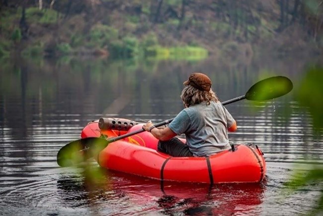
Larsen and others have been monitoring the impacts of the fire on water clarity and lake chemistry since 2018 when the fire abated (Figure 8). Her team has also been monitoring a similar lake (YUCH-083) near Chester Bluff that is outside the fire perimeter, which serves as a control site.
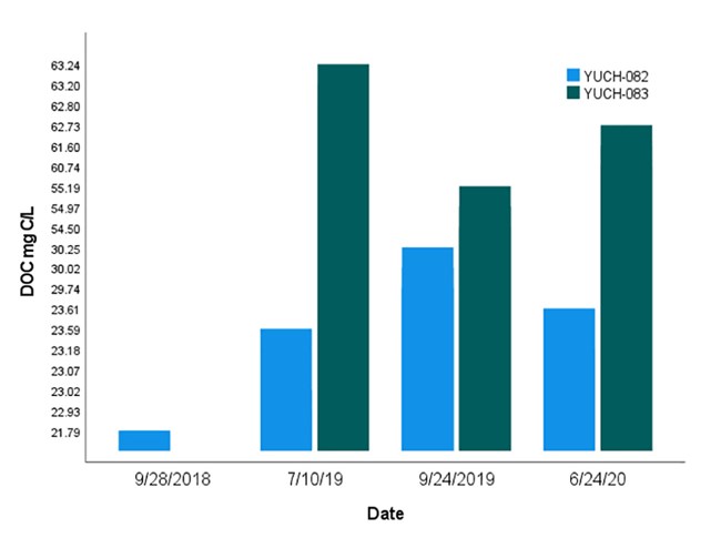
The comparison has yielded some interesting results: dissolved organic carbon (DOC) concentrations measured during the growing season are lower in the fire-affected lake but have increased significantly since the fire, whereas DOC in the control lake has decreased (Figure 9). Increasing DOC concentrations at YUCH-082 suggest the lake is receiving a new source of carbon, likely drawn in part from carbon trapped in the degrading ice wedges. DOC concentrations in the control lake are higher in spring compared to fall, likely due to lake metabolism occurring in summer. Conversely, DOC concentrations in YUCH-082 increase over the summer as ice-wedges are actively thawing and are consumed over winter.
To better understand the source of DOC, the team looked at SUVA, a measurement of carbon quality. High SUVA values indicate complex carbon molecules while low SUVA values indicate more labile sources of carbon. SUVA measurements in the fire-affected lake were low (0.54 L mg‐C−1 m−1) compared to the control site (2.39 54 L mg‐C−1 m−1). The difference in SUVA values indicate that in the fire affected lake (YUCH-082), the new carbon is likely coming from the degrading ice wedges, whereas carbon in the control lake (YUCH-083) is coming from complex carbon molecules (degraded leaf litter, tannins) in the watershed. Radiocarbon dates from both lakes support this theory; DOC measured in YUCH-082 was considerably older (1900-2410 BP) than the modern-era carbon found in the control lake. This suggests that the increase in DOC in YUCH-082 is likely derived from ancient carbon previously trapped in the surrounding yedoma. These findings were mirrored in aquatic ecologist Trey Simmons’ stream monitoring sites within the Andrew Creek fire. In 2020, dissolved organic carbon in two different streams dated to 1,080 and 1,820 BP, indicating ancient C inputs to streams likely sourced from the deteriorating permafrost as the streams cut through the landscape (Figure 5).
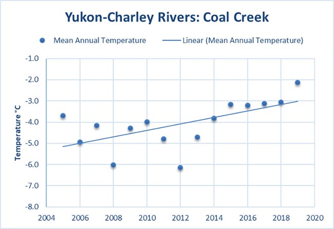
Long-term climate trends are likely contributing to subsidence, landslide formation, and erosion in the Andrew Creek Fire area. Physical scientist Pam Sousanes reports that since the fire burned in the summer of 2018, there have been several weather and climate extremes that may have contributed to permafrost degradation. This area in general has been warmer and wetter than normal for the past several years. 2019 was the warmest year on record for the state of Alaska, with the average annual temperature in Eagle >2°C warmer than the 1981-2010 normal. The climate site at Coal Creek in Yukon-Charley, near the Andrew Creek Fire area, has a shorter record but shows persistent warm annual temperatures since 2014 (Figure 10). Regional temperatures did moderate in 2020 for the first time in six years with a slight cool tilt in eastern Alaska.
Since the fire occurred in 2018 conditions in the region have generally been wet. Eagle with >60 years of data had two of the wettest summers on record in the past three years (2018 and 2020) and the 2019-2020 snowfall total was one of the highest on record. In April of 2020, a record 30 inches of snow with a snow water equivalent of 5.5 inches was recorded at Coal Creek (2007-2020). Even with a shorter period of record the recent wet summers stand out at the Coal Creek site. In 2019 a weather station was installed within the fire perimeter. Data from this site will be retrieved in 2021 which will provide on-site weather conditions for the area affected by the fire.The record high temperatures and precipitation rates have likely exacerbated post-fire landscape deterioration in the remaining yedoma-dominated landscape. As mean annual temperatures approach 0℃, permafrost will become less stable, and the transition of the landscape from yedoma- and permafrost-dominated systems will accelerate. Higher over-land flow caused by precipitation will intensify erosion and the formation of landslides as once permafrost-supported land begins to collapse and subside. As the interior parks climb toward a new climate threshold, it becomes increasingly important to monitor the rapid changes occurring around us—and document the continuing transformation of the Andrew Creek Fire area.
The Andrew Creek Fire project is an example of the insight that can be gained when multiple disciplines coordinate their questions and sampling. It’s also an example of taking advantage of natural experiments when they occur. This type of approach promotes the ability of parks to learn about how the function of the landscape is altered in response to fire disturbance.
Acknowledgements
Thanks to the NPS Reserve Fund Research grant that supported field work and imagery collection in 2019 and will continue support in 2021. Thanks to the Central Alaska Network and all our colleagues who work on and support this project.
References
1 Key, C. H. and N. C. Benson. 2006. Landscape Assessment (LA). In ‘FIREMON: Fire Effects Monitoring and Inventory System’. (Eds DC Lutes, RE Keane, JF Carati, CH Key, NC Benson, LJ Gangi) USDA Forest Service, Rocky Mountains Research Station General Technical Report RMRS-GTR-164-CD. p. LA-1-55 (Fort Collins, CO).
2Kasischke, E. S., M. R. Turetsky, R. D. Ottmar, N. H. French, E. E. Hoy, and E. S. Kane. 2008. Evaluation of the composite burn index for assessing fire severity in Alaskan black spruce forests. International Journal of Wildland Fire 17(4): 515-26.
For more information, also see: Fire and Ice, Birds and Burns, Lakes and Streams
