Last updated: November 26, 2024
Article
How Rare is Rare? Understanding Apostle Islands Ice Caves Access

NPS / Amanda Hernandez
The Apostle Islands ice caves near Meyers Beach are a stunning natural phenomenon. However, the opportunity for visitors to access them has only been possible during a rare convergence of factors. Cold temperatures can form thick ice, but wind and waves rippling across the largest lake in the world can quickly break up seemingly stable ice.
This article examines the historical rarity and delicate balance of conditions necessary for access to the Apostle Islands ice caves. It also explains the difficulty surrounding good ice conditions along this portion of Lake Superior's shoreline and larger patterns of diminishing ice cover.

How Rare is Rare?
As of 2024, the last time stable ice allowed access to the ice caves was for a brief nine-day period in 2015. From 2000 to 2023, the Mainland Ice Caves were open for only 2 percent of all days. Moreover, most ice cave events since 2000 have occurred in just four outlier years: 2004, 2008, 2009, and 2014.
Conditions for Access
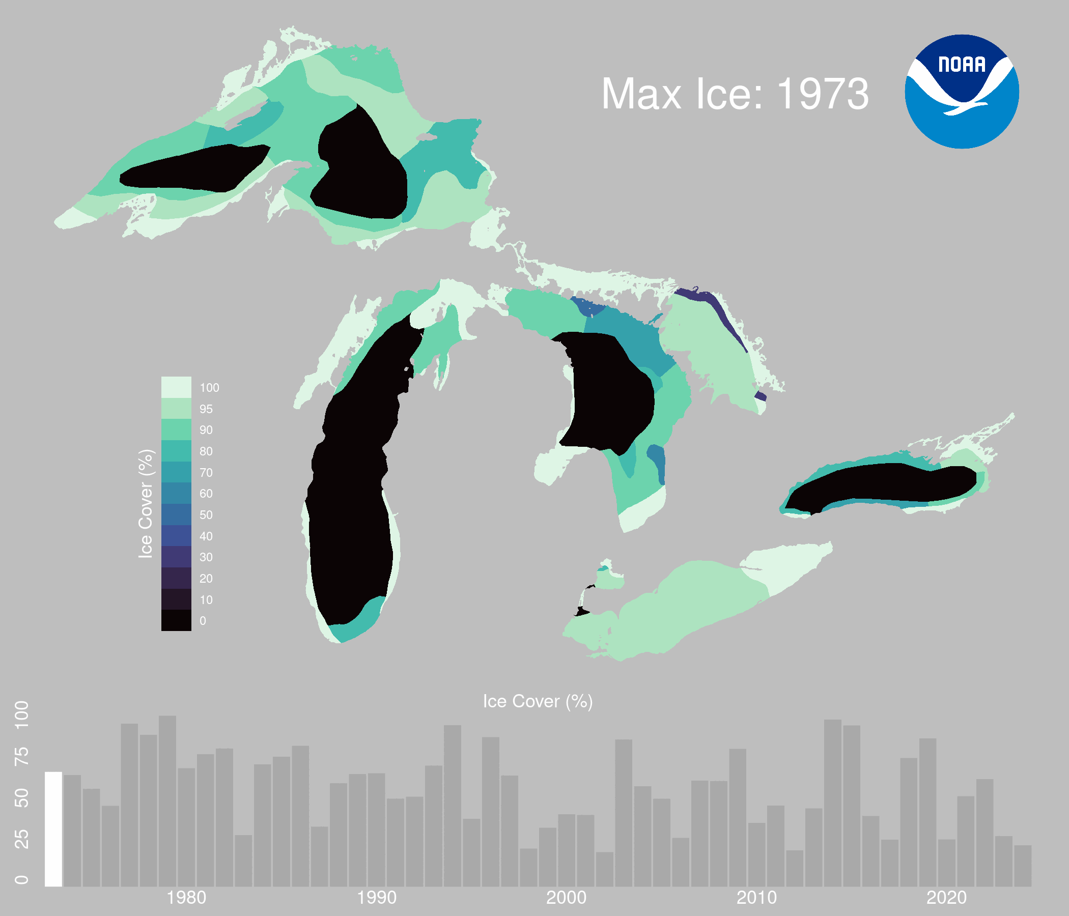
To safely walk across the surface of Lake Superior to reach the ice caves, several critical conditions must align. First, extended periods of extreme cold, ideally below zero, paired with little or no wind, are essential for forming stable ice. Any warm spells or moderate winds can quickly disrupt the developing ice shelf. Additionally, the Apostle Islands ice caves have only been accessible during years when Lake Superior's ice coverage exceeded 90%. In 2014 and 2015, ice coverage peaked at over 95%. However, the annual average maxium ice cover is only 60%.1

NPS / Billy Flynn
On February 6, 2013, the park was ready to announce that the Ice Caves would open. However, by 8 a.m. the following day, the ice shelf began to break up. By 8 a.m. on February 8, the entire area was open water.


Left image
5 pm February 6, 2013
Credit: Sea Caves Watch
Right image
8 am February 7, 2013
Credit: Sea Caves Watch
Location Challenges
Wind and waves rippling across the largest lake in the world can quickly break up seemingly stable ice.
The ice caves are situated along the northeastern shoreline from Meyers Beach, which is exposed to the open waters of Lake Superior. This exposure allows wind and waves to disrupt ice formation. For ice to be stable, it must connect with land masses, but the considerable distance between these locations makes this rare. Furthermore, from the Meyers Beach parking area, visitors must walk at least 1.5 to 3 miles across the frozen surface of the lake to reach the beginning of the ice caves.
The satellite images below show ice cover on the lake in March 2014 (left image), when the ice caves were safe for visitor access, and March 2024 (right image), when there was very little ice cover. The images highlight the extreme annual variability of ice cover on Lake Superior.


Left image
March 2014 MODIS satellite image of Lake Superior
Credit: NOAA CoastWatch: Great Lakes Node
Right image
March 2024 MODIS satellite image of Lake Superior
Credit: NOAA CoastWatch: Great Lakes Node


Left image
March 2014 MODIS satellite image of Lake Superior
Credit: NOAA CoastWatch: Great Lakes Node
Right image
March 2024 MODIS satellite image of Lake Superior
Credit: NOAA CoastWatch: Great Lakes Node
Trends in Lake Superior Ice Cover
In 2014 and 2015 when the ice caves were last open, ice coverage on the lake was more than 95%. That level of ice coverage is rare.

Great Lakes Environmental Research Laboratory
In years when the Apostle Islands National Lakeshore ice caves have been accessible, Lake Superior maximum ice cover has been over 90%. In 2014 and 2015 when the ice caves were last open, ice coverage on the lake was more than 95%. That level of ice coverage is rare. The long-term average maximum annual ice cover on Lake Superior dating back to 1973 is 60%.
NOAA Great Lakes Environmental Research Laboratory
Impact of Climate Change
The length of the local ice season is getting shorter.
Climate change poses additional challenges to the formation of safely-accessible ice caves. The length of the local ice season has been trending shorter. Local records collected from the Madeline Island Ferry Line and the Bayfield County Press were analyzed by Forrest Howk. They show that since 1975, the local ice season has begun an average of 11.7 days later and ended 3.0 days earlier every decade.3
Additionally, surface water and Lake Superior basin air temperature records show a warming trend.4 The warmer surface water and air temperatures could continue to shorten the duration of stable ice cover, delay ice formation, and destabilizes existing ice.

Great Lakes Integrated Sciences and Assessment
Conclusion
The Apostle Islands ice caves represent a breathtaking intersection of natural beauty and environmental complexity. Their stunning formations, shaped by the ever-changing elements of Lake Superior, have become a rare treasure, accessible only when specific conditions align. As we witness shifting climate patterns and diminished ice coverage, understanding the delicate balance that allows for visitor access becomes increasingly vital.