Last updated: September 13, 2024
Article
Marshall Islands
The Marshall Islands are located in the central Pacific Ocean, roughly between Hawai’i and the Philippines, north of the equator and west of the International Date Line. They include 29 coral atolls and over 1200 islands and islets, situated in two island chains extending over 800 miles in length. While their total land area is about 70 square miles (181 km2), barely larger than Washington, DC, the Marshall Islands have the largest portion of territory made of water of any sovereign state, at over 97%. These atolls and islands are home to diverse animal and plant species and have been inhabited by humans for thousands of years.
Today they are officially known as the Republic of the Marshall Islands, an independent nation with free association with the US, which provides them with defense, subsidies, and access to US-based agencies such as the Federal Communications Commission and the Postal Service. Their present population is around 43,000.
During WWII
Much like the Mariana Islands, the Marshall Islands were important during World War II because their location provided opportunities to access targets across the vast distances of the Pacific Ocean. The Germans had ceded the Marshall Islands to the Japanese in 1919. They were largely neglected until World War II, when the Japanese saw their potential as a forward base for possible attacks on Australia, British colonies, and even the United States. Military airfields were built on Kwajalein, Maloelap, and Wotje atolls, and seaplanes were based at Jaluit. The United States Pacific Fleet carried out raids on those islands in 1942, the first air raids on Japanese territory in the war. By autumn of 1944, the US controlled most of the Marshall Islands.
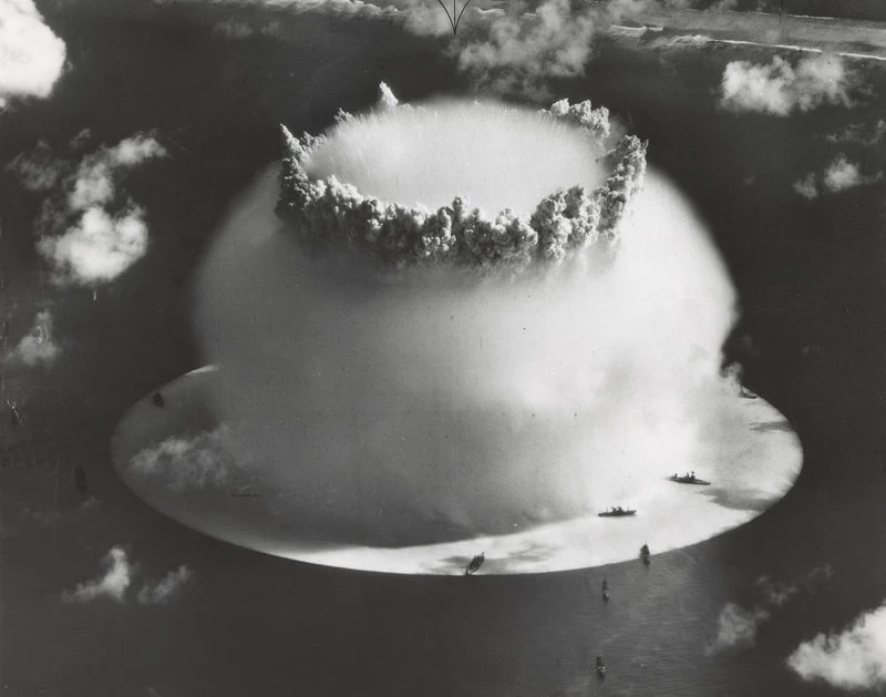
Nuclear Weapons Testing after WWII
Public Domain
After the war ended, the US chose the Marshall Islands as a nuclear weapon testing site. Operation Crossroads in July of 1946 included two tests at Bikini Atoll, the first atomic tests since Trinity a year before. They were carried out by Joint Army/Navy Task Force One rather than by the Manhattan Project. The tests were intended to investigate the effects of nuclear weapons on warships, since both of the bombs used during the war had been on land. The tests included a target fleet of over 90 empty ships in the atoll’s lagoon, and had a large, invited audience that included journalists. Both tests employed implosion-type plutonium bombs similar to the Fat Man weapon used at Nagasaki, each with an expected yield of 23 kilotons.
Test Able, July 1, 1946, employed a bomb dropped from the air. It caused less damage to the targets than expected, in part because it was unintentionally dropped nearly a half mile (650 meters) from the target area. For Test Baker on July 25, the device was detonated 90 feet (28 meters) underwater; it caused great amounts of damage, including heavy radiation contamination. Between 1946 and 1958, the US conducted 67 nuclear tests at Bikini and Enewetak atolls.
Displacement of Marshallese
Prior to the tests, Bikini’s 167 Marshallese were convinced to evacuate temporarily. They were moved to Rongerik, which turned out to have inadequate water and resources to support them. They were then moved temporarily to Kwajalein, and then to Kili; some moved on to Ejit. In 1972 about 100 moved back to Bikini, where the radiation levels were thought to have fallen to safe levels. However, in May 1978 scientists found high strontium levels in well water and the residents’ body burden of cesium-137 to be excessively high, and the people were again evacuated. The US government established trust funds to cover medical treatments and a small annual payment to individuals. The Bikini people and their descendants are now spread out to other Marshallese islands and Majuro, the country’s capital; the United States; and other countries. Bikini is a World Heritage Site, and the “ghost fleet” in the lagoon is a destination for sport divers, but it is not yet safe for its native inhabitants to return due to radioactive contamination.
Rhodes, Richard. 1996. Dark Sun. Simon & Schuster. https://www.simonandschuster.com/books/Dark-Sun/Richard-Rhodes/9780684824147.
"Marshall Islands." US Department of State. 2024. https://www.state.gov/countries-areas/marshall-islands.
Wikipedia. 2024. "Bikini Atoll." Wikimedia Foundation. Last modified September 3, 2024. https://en.wikipedia.org/wiki/Bikini_Atoll.
Wikipedia. 2024. "Enewetak Atoll." Wikimedia Foundation. Last modified August 29, 2024. https://en.wikipedia.org/wiki/Enewetak_Atoll.
Wikipedia. 2024. "Kwajalein Atoll." Wikimedia Foundation. Last modified August 15, 2024. https://en.wikipedia.org/wiki/Kwajalein_Atoll.
Wikipedia. 2024. "Marshall Islands." Wikimedia Foundation. Last modified September 5, 2024. https://en.wikipedia.org/wiki/Marshall_Islands.
Wikipedia. 2024. "Operation Crossroads." Wikimedia Foundation. Last modified August 30, 2024. https://en.wikipedia.org/wiki/Operation_Crossroads.