Last updated: May 21, 2024
Article
Terrestrial Vegetation Monitoring 2020 Data Summary for Fort Frederica National Monument

Overview
Vegetation communities are dynamic entities influenced by environmental factors and impacts from natural and anthropogenic disturbances. The diversity of plants within the southeastern Coastal Plain contributes to a range of ecological services, provides habitat and resources to an array of wildlife, and functions as nature’s backdrop—usually the primary visual cue pulling us toward an appreciation of the outdoors. Determining trends in vegetation communities over time and identifying plant stressors is vital to understanding the ecological health of terrestrial ecosystems within Southeast Coast Network (SECN) parks. Collectively, this information can be used to guide management actions that sustain park’s ecological integrity and support plant conservation across a diversity of spatial scales for generations to come.
Methods
The Southeast Coast Network collects long-term data on terrestrial vegetation within its parks using a peer-reviewed protocol similar to other NPS Inventory and Monitoring networks in the eastern U.S. and is modeled after the approach used to describe natural vegetation in the Southeast developed by the Carolina Vegetation Survey. Permanent plots are used as the sample unit to determine a site’s (1) vascular plant richness and abundance for all native and non-native species; (2) basal area, density, and health for all trees; (3) density of forest floor fuels; (4) community level disturbance events, including presence of insect pests and disease; and (5) abiotic condition (e.g., landform shape, soil nutrients, canopy coverage and height). Plots are randomly located across broadly defined habitat types within SECN parks. Our sampling effort focuses on dominant (> 30% coverage) habitat types within these parks, but when time and resources allow, the sampling effort is increased to include less dominant types. The Terrestrial Vegetation Monitoring Protocol provides detailed descriptions of field and data processing techniques used by the Southeast Coast Network.
Study Area
Fort Frederica National Monument (FOFR) is on St. Simons Island in Glynn County, Georgia. The 123-hectare (305-acre) park is split between two parcels on the island—the primary management unit and the Bloody Marsh Battle Site. The primary management unit is located on a bluff on the western central part of St. Simons Island overlooking the Mackay (Frederica) River and includes the park headquarters, visitor center, and historical fort. The focal area of the park is the colonial-era townsite surrounding the fort, which is currently maintained as a mowed field. The current vegetation of Fort Frederica National Monument includes upland forests dominated by a mixture of live oak (Quercus virginiana) and other hardwoods or pine (Pinus sp.)-dominated successional forests occupying sites that were originally hardwood-dominated. Salt marsh vegetation, dominated by smooth cordgrass (Spartina alterniflora) and black needlerush (Juncus roemerianus), occupy the lowest vegetated sites of the park along the Frederica River. This protocol was implemented for the first time within the park in 2020, and these data represent the baseline status of vegetation and associated abiotic elements from Maritime Upland Forest and Shrubland habitat within the park. Five plots were established across this habitat (see map).
Significant Findings
Site and Environmental Factors
Like the other barrier islands along Georgia’s coast, natural vegetation communities within Fort Frederica are strongly influenced by maritime-influenced tides, prevailing ocean winds and storms, and sedimentation from rivers. Strong storm events and highly saline environments affect the distribution of plants across the island, impacting the mosaic of marsh and forested habitats. Furthermore, vegetation diversity is largely influenced by complex edaphic factors and their associated relationship with site hydrology and disturbance patterns (e.g., fire, storms). These wide-ranging environmental conditions were observed in the soil and disturbance data collected from vegetation plots. Most soils within these plots were acidic. Several observable disturbances were documented within the park’s forested ecosystems; windthrow was observed in all five of the plots.

Vegetation
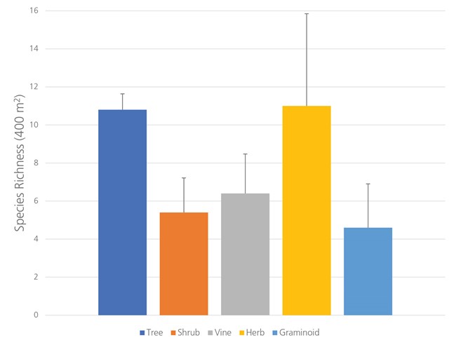
Ninety-one plant species were observed across all plots, including 19 taxa not detected in previous plant surveys and one species listed as rare and tracked by the Georgia Department of Natural Resources. Overall plot level plant richness ranged from 27 to 49 species, with trees and herbaceous species dominating.

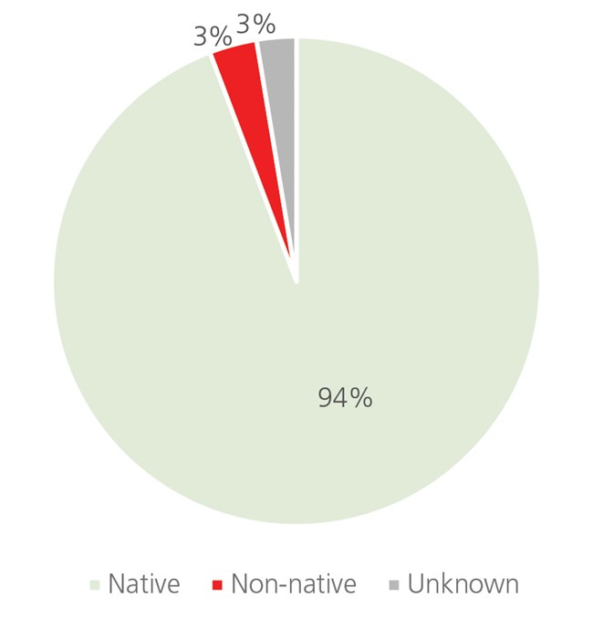
Non-native species were encountered in all but one of the five vegetation plots sampled within the park. Two non-native species categorized as invasive by the Georgia Exotic Pest Plant Council were encountered in four different Maritime Upland Forest and Shrubland plots; these included camphortree (Camphora officinarum) and Chinese tallow (Triadica sebifera). Maritime Forest and Shrubland habitats within the park typically had a tree canopy dominated by Darlington oak (Quercus hemisphaerica) and loblolly pine (Pinus taeda).

NPS photo / M. Forbes Boyle.
Other Findings
- Frequent windthrow and historical land use impacts (e.g., agriculture, timber management) have contributed to the lack of older-aged maritime forests across the park; most of the forested canopy is composed of species more typical of younger maritime forests (e.g., Darlington oak, pines). Continued monitoring of these plots will determine whether species more typical of mature maritime forests (e.g., live oak) are increasing in frequency/abundance.
- All plots are scheduled to be resampled in summer 2024.
Full Report
The full report for Terrestrial Vegetation Monitoring at Fort Frederica National Monument 2020 Data Summary
About the Southeast Coast Network
In 1999, the National Park Service initiated a long-term ecological monitoring program, known as “Vital Signs Monitoring,” to provide the minimum infrastructure to allow more than 270 national park system units to identify and implement long-term monitoring of their highest-priority measurements of resource condition. The overarching purpose of natural resource monitoring in parks is to develop scientifically sound information on the current status and long-term trends in the composition, structure, and function of park ecosystems, and to determine how well current management practices are sustaining those ecosystems.
The NPS Vital Signs Monitoring Program addresses five goals for all parks with significant natural resources:
- Determine the status and trends in selected indicators of the condition of park ecosystem,
- Provide early warning of abnormal conditions,
- Provide data to better understand the dynamic nature and condition of park ecosystems,
- Provide data to meet certain legal and Congressional mandates, and
- Provide a means of measuring progress towards performance goals.
The Southeast Coast Network (SECN) includes eighteen administrative areas containing twenty park units, fifteen of which contain significant and diverse natural resources. In total, SECN parks encompass more than 184,000 acres of federally-managed land across North Carolina, South Carolina, Georgia, Alabama, and Florida. The parks span a wide diversity of cultural missions, including four national seashores, two national historic sites, two national memorials, six national monuments, two national military parks, as well as a national recreation area, national battlefield, national historical park, and an ecological and historic preserve. The parks range in size from slightly more than 20 to nearly 60,000 acres, and when considered with non-federal lands jointly managed with the National Park Service, the network encompasses more than 253,000 acres.
For More Information
SECN Home Page
https://www.nps.gov/im/secn/index.htm
SECN Reports & Publications
https://www.nps.gov/im/secn/reports-publications.htm
About the NPS Inventory & Monitoring Program
https://www.nps.gov/im/index.htm
Data Downloads via the Natural Resource Information Portal
https://irma.nps.gov/Portal/
