Last updated: July 17, 2024
Article
The Shipwreck Tagging Archaeological Management Program (STAMP)
Climate change compels National Park archeologists to use science to save valuable data from deteriorating and disappearing back into the sea. In response, the National Park Service’s Submerged Resources Center (SRC) and its partners are expanding their shipwrecking timber tracking initiative, the Shipwreck Tagging Archaeological Management Program (STAMP), to encompass all national parks with bodies of water.
Through STAMP, the public helps archeologists monitor shipwrecks to understand how sites change over time. Natural conditions like wave action, storms, tides, and currents can all cause coastal and intertidal submerged sites to erode and degrade. Human factors like vandalism and looting, construction, dredging, and development also have adverse effects on these sites. Occasionally both natural and human factors can detach or disarticulate wooden timbers from historic shipwrecks. These timbers may wash ashore, become covered or uncovered by sand, wash out to sea again, and travel enormous distances pushed by waves and wind. Tracking these timbers will increase knowledge of site formation and change and may even lead to the discovery of previously unrecorded wrecks.
The Florida Public Archaeology Network (FPAN) initiated STAMP at Gulf Islands National Seashore. The first FPAN workshop tested STAMP documentation and tagging on a timber brought to the park as an example of how STAMP can help archeologists track the degradation of shipwrecks over time and how storms and hurricanes affect these sensitive archeological sites.
What is STAMP?
Through STAMP, the public helps archeologists monitor shipwrecks to understand how sites change over time. Natural conditions like wave action, storms, tides, and currents can all cause coastal and intertidal submerged sites to erode and degrade. Human factors like vandalism and looting, construction, dredging, and development also have adverse effects on these sites. Occasionally both natural and human factors can detach or disarticulate wooden timbers from historic shipwrecks. These timbers may wash ashore, become covered or uncovered by sand, wash out to sea again, and travel enormous distances pushed by waves and wind. Tracking these timbers will increase knowledge of site formation and change and may even lead to the discovery of previously unrecorded wrecks.The Florida Public Archaeology Network (FPAN) initiated STAMP at Gulf Islands National Seashore. The first FPAN workshop tested STAMP documentation and tagging on a timber brought to the park as an example of how STAMP can help archeologists track the degradation of shipwrecks over time and how storms and hurricanes affect these sensitive archeological sites.

How does STAMP work?
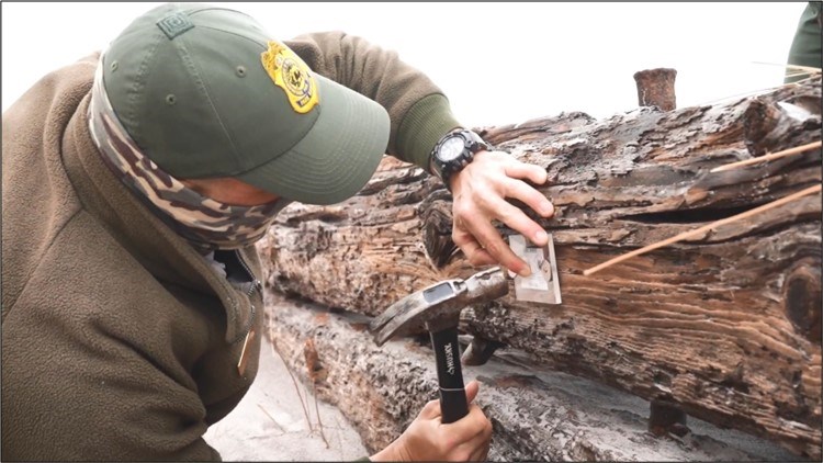
STAMP projects consist of two distinct execution phases: tagging and recording. During the tagging phase, trained staff and volunteers participate in documenting shipwreck remains.First, a standard operating procedure (see the forms at the end of this article) instructs users on the proper technique to affix tags onto shipwreck elements and disarticulated timbers. The participant will use their judgment to find a structurally strong location on the shipwreck timber to affix the tag. If the site is a shipwreck site with multiple exposed timbers, the participant should affix tags onto a selective sample of structural elements based on integrity and on which elements are exposed.

Second, the volunteer will use the STAMP Deployment form (see the forms at the end of this article) to describe the object they tagged. The deployment form acts as the data recorder for deploying new tags. The tools needed to measure and collect the information about each wreck will be provided in a STAMP toolbox with a list (see the forms at the end of this article) of the equipment inside. The STAMP toolboxes and included materials are provided to each National Park participating in STAMP on behalf of the Submerged Resources Center.
All materials and information for the tagging phase are collected and stored in STAMP toolboxes. The STAMP toolboxes contain all the materials needed to properly document and tag untagged shipwreck sites/timbers. The kit includes QR code tags, stainless steel nails, stainless steel washers, a hammer, and measuring tapes. The deployers of the QR code tags should bring a north arrow, a camera, and photo cards if available. All of these materials are kept in specially marked toolboxes which are sent to the park’s Culture Resource Managers so trained volunteers or staff can check out the boxes when necessary.
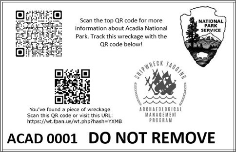
Recording, STAMP’s second execution phase, allows anyone who comes in contact with a tagged shipwreck timber to contribute to the project. The public participant uses their smartphone to scan the QR code or to enter the uniform resource locator (URL) found on the tag. This action automatically takes the user to the enhanced online submission form, which FPAN linked to the STAMP database. This form invites the user to answer a series of questions relating to the tagged timber’s location and integrity.
Most importantly for archeologists, the online form allows the user to upload global positioning system (GPS) coordinates and photos. Upon receipt of the user form, the public participant is asked to “turn GPS location on.” This action grants permission for the form to extract the GPS information stored in the user’s phone during submission.
The first question on the form asks the participant whether the tag was found on the wreckage. The answer to this question indicates to the archeologist whether the tag has withstood the oceanic environment and stayed on the shipwreck timber. The second question asks the participant when they found the tagged timber. Over time, this question may assist archeologists with when to expect to encounter cultural resources in certain geographic locations along the coastline. The third question prompts the user to upload global positioning system coordinates for the tagged timber location, allowing archeologists to see where the timber has moved over time. The fourth question directs the user to indicate how exposed or buried the tagged timber is within the surrounding sediment. This question provides archeologists insight on how likely the timber is to be dislodged and potentially recorded again in the future. The last question encourages the participant to upload photos of the tagged timber, providing archeologists with a visual record of the shipwreck timber/shipwreck site and how it changes over time. If a participant does not want to answer one of the questions, they may not be able to submit the form. The only question that is optional for the user is the last question: uploading photos.
A submission triggers two effects: the population of the online database and the transmission of feedback to the user. The submission is immediately sent to the online database, and alerts are sent to the project archeologists. A feedback form is also immediately generated for the citizen scientist participant, thanking them for their submission. In addition, the feedback response contains a heat signature map displaying dots that illustrate where the public has already reported shipwreck timbers. If the user selects one of the dots or tagging locations, information such as the submission date and any photographs of the resource are provided to the user. The automatic feedback generated by the online database is available to the public participant for one hour after recording. The feedback provided gives the citizen scientist participant a sense of value (ownership) in contributing to our shared maritime history and urges them to continue participating in the program.
STAMP in NPS
The STAMP tags for the National Park Service have two QR Codes, one linking the user to a questionnaire about the shipwreck’s condition, which is collected through the internet and stored in a linked database. The other QR code links the user directly to a National Park Service webpage chosen by the resource managers at the park.As parkgoers explore the National Seashore and discover a beached wreck for themselves, they approach the wreckage to see QR codes sealed in plexiglass and nailed to the timbers. They can scan a QR code and read about the natural and cultural history of the National Seashore or check the other QR code and document the unique aspects of their find.

At all national seashores, the QR code asks the volunteer to fill out the five-question questionnaire while providing coordinates and a photograph. This information is subsequently stored in a linked database and enables archeologists and park resource managers to see the shipwreck’s condition in real-time. For instance, in 2021, at Fire Island National Seashore, park managers tagged Bessie White before Hurricane Henri struck, and parkgoers documented the change the hurricane had on the landscape and the shipwreck.

Form No. 2: STAMP Deployment Form
Form No. 3: STAMP Kit Materials List
For More Information
Burkhard, A. L. Shipwreck Tagging Archaeological Management Program (STAMP): A Model for Coastal Heritage Management Based on Community Engagement and Citizen Science. Pensacola: University of West Florida. 2020.STAMP: Shipwreck Tagging Archaeological Management Program, Florida Public Archaeology Network.
