Last updated: August 23, 2022
Article
Weather and Climate Resource Brief for the Arctic Network

NPS/Travis Monahan
STATUS & TRENDS
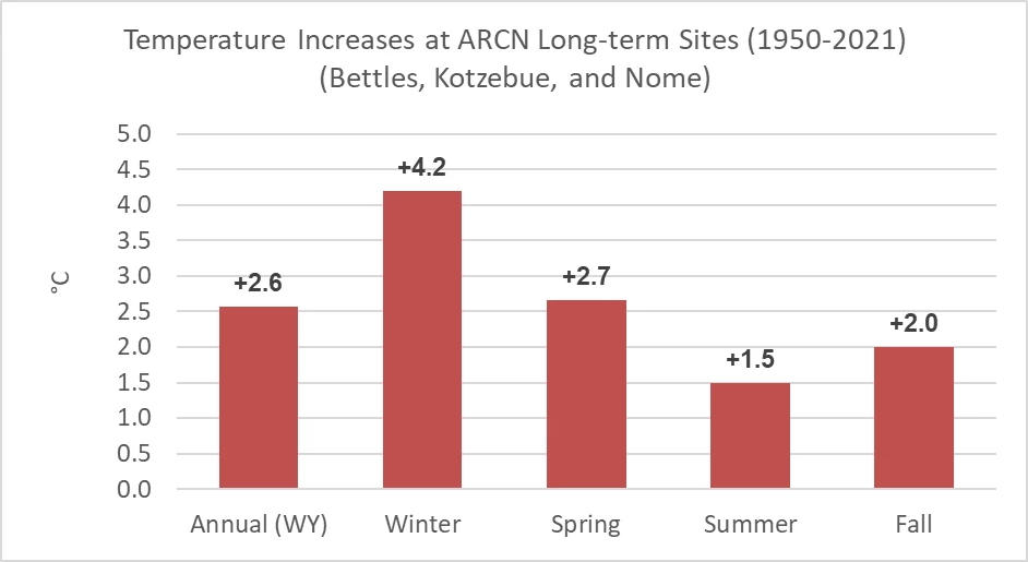
Weather and climate are key physical drivers of ecosystem structure and function. Temperatures across Alaska are rising much faster than at lower latitudes. Trends in Arctic Alaska’s average annual air temperatures from 1950 to 2021, our longest consistent record, show a significant temperature increase of >2.6°C in the communities in and around Alaska’s Arctic national parks. Over the 72-year period winter temperatures warmed by 4.2°C, spring temperatures by 2.7°C, summer temperatures by 1.5°C, and fall temperatures by 2.0°C (below).


Rain and Snow
Annual rainfall and snowfall amounts are much more variable and are not as spatially coherent as temperature, but the Arctic parks have all become wetter in the past 70 years. The seasonality of that increase, whether it falls as snow in the winter or rain in the summer, is ecologically important in the Arctic parks. The data from Kotzebue and Nome, near the northwestern Alaska parks indicate a significant increase in winter snowfall or ‘cold’ season precipitation (Oct-Apr). In Bettles, near Gates of the Arctic NP&P, both the warm season and cold seasons have had significant increases in precipitation, although the trend is stronger for the warm season (May-Sep).In Bettles, the total annual precipitation has increased by 114 mm over the past 70 years. The warm season precipitation, summer rainfall plus the shoulder season rain of May and September, has increased by 76 mm over this period. The cold season precipitation total, which is a good indication of the seasonal snowpack, has increased by 38 mm. On average, Bettles receives 371 mm of precipitation annually. Summer rainfall accounts for 42% of the annual total.
In Kotzebue, the annual precipitation total has increased by 105 mm since 1950. Almost all of that increase has occurred during the cold season months, which saw a significant increase of 96 mm in the past 72 years. Conversely the warm season increase was only
8 mm, with no trend. Kotzebue has relatively low annual precipitation, and like most Alaskan communities the wet season is in the summer. June, July, and August rainfall account for more than half of the annual precipitation total.
Nome is also getting wetter in the cold season. There has been a significant increase in precipitation totals for October, December, and February in Nome. There is no trend in warm season precipitation and summer rainfall totals have not increased over the past 70 years. The total annual precipitation for Nome is 415 mm, about 60% of that falls during the warm season between May and September, with August as the wettest month of the year.
Why climate is important
Climate is the most important broad-scale factor influencing ecosystems. Because global climate models indicate that climate change and variability will be greatest at high latitudes, climate data from these northern parks will help us understand the changing conditions of park ecosystems. Monitoring is critical to understanding how warming temperatures and changes in precipitation will impact park ecosystems, resources, and communities now and in the future. Potential effects in the Arctic parks include a reduced snowpack, earlier ice break-up on lakes, warmer winters, and wetter summers. These changes may affect the distribution, abundance, growth, and productivity of plants and animals.What we want to know about vital sign
We monitor and record weather conditions at representative locations in the parks in order to:
- identify long- and short-term weather and climate trends
- provide reliable climate data to other researchers
- participate in larger-scale monitoring and modeling efforts beyond park boundaries

How we monitor climate
There are 21 climate stations (17 Arctic Network Remote Automated Weather Stations [RAWS], 3 fire RAWS, and 1 Snotel [automated data collection network that provides hydroclimatic data from mountainous regions in the western US]) across the Arctic Network parks that continuously record temperature, summer rainfall, wind speed and direction, soil temperature, relative humidity, and solar radiation. Snow depth is measured at some of the more protected sites. Many of these sites are in exposed, windy locations where it is difficult to measure snow accurately. These rare high-latitude weather stations, along with the stations in nearby communities (Nome, Kotzebue, and Bettles), provide critical quantitative data for current and future research and management decisions.How monitoring climate can help park managers
Climate monitoring is critical to understanding the changing conditions of park ecosystems. The effects of our warming climate on Alaska park resources can be dramatic in the form of melting glaciers and permafrost, more frequent fires, and changes in vegetation. The data and information gathered from Alaska's parks provide an important piece of the puzzle for understanding the drivers and effects of climate change locally and regionally (even globally).Discover More about Climate in Alaska's Parks
Climate Monitoring for the Arctic Inventory and Monitoring Network
See the most recent data from our climate stations
Quarterly climate predictions from the National Weather Service
Long term climate projections can be found at Scenarios Network for Alaska Arctic Planning
Information on Arctic Sea Ice Extent from NASA Arctic Sea Ice Minimum
More on snow and ice cover can be found at the National Snow and Ice Data Center
Alaska Scientists on Climate Data Quest Get Rare View of Parks (nbcnews.com)
Swanson, D. K., P. J. Sousanes, and K. Hill. 2021. Increased mean annual temperatures in 2014-2019 indicate permafrost thaw in Alaskan national parks. Arctic, Antarctic, and Alpine Research 53(1): 1-19.
For more info, contact:
Pam Sousanes, Physical Scientist
907-455-0677
pam_sousanes@nps.gov
Ken Hill, Physical Scientist
907-455-0678
kenneth_hill@nps.gov