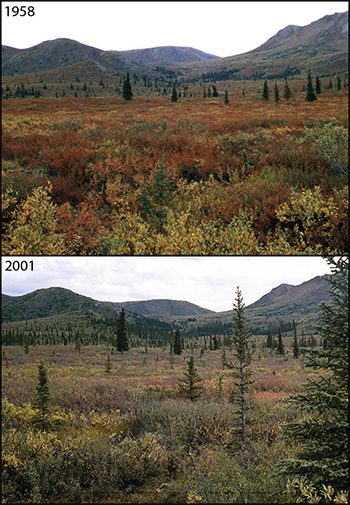
Leslie A. Viereck (1958), Leslie A. Viereck (2001)
Denali Repeat Photography Project
The Denali Repeat Photography project has assembled more than 200 photo pairs taken across a large cross-section of Denali from the low-lying black spruce forests to ice fields high in the Alaska Range. What unites these disparate images is that they show repeated views of a single location at different moments in time. The interval separating the pairs of photos varies greatly – from just a few years to longer than a century.
USGS Repeat Photography Project – Glacier
The Repeat Photography Project began in 1997 with a systematic search of the archives at Glacier National Park. Since 1997 over sixty photographs have been repeated of seventeen different glaciers. Thirteen of those glaciers have shown marked recession and some of the more intensely studied glaciers have proved to be just 1/3 of their estimated maximum size that occurred at the end of the Little Ice Age (circa 1850). In fact, only 26 named glaciers presently exist of the 150 glaciers present in 1850.
Digital Earth Watch
Digital Earth Watch (DEW) brings together biology, physics, chemistry, technology, art, engineering, and math in a project that supports environmental science field studies in middle schools, high schools, self-guided education, and citizen science. This site has free software, ideas for activities, and challenge questions.
PicturePost - Doing your own repeat photography
Picture Post is a part of the Digital Earth Watch (DEW) network. You can contribute photographs to any Picture Post, add your own Picture Post, measure environmental change in your neighborhood, and contribute to science networks.
Measuring Vegetation Health with PicturePosts
Abstract: The Boston Museum of Science developed monitoring stations called PicturePosts as part of its Measuring Vegetation Health program. Despite their many educational applications, PicturePosts had not been implemented in an educational environment. To encourage and assist in their use, we formed an advisory board of educators who provided input and feedback as we developed an educator’s guide and installation and software manuals for PicturePosts. The educators’ impressions of the Posts support the program’s far-reaching potential to enhance science education.
Repeating Historic Photos of the Sierra Nevada
Alpine of the Americas Project (AAP) provides climate scientists useful observations of alpine changes while providing individuals enjoyable experiences in the mountains. Viewing ecosystem changes through repeated photos may that influence community decisions about natural resources.
Video: Repeating Historic Photos of the Sierra Nevada
Interested in the process of repeating historic photographs? View the video to walk through the steps you need to take to repeat historic photos.
Part of a series of articles titled Panoramic Project Shows How National Parks Change Over Time.
Previous: Panoramic Lookout Project Parks
Last updated: September 18, 2018
