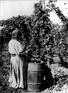
The Evergreen State is more famous for its apples than the obscure hop vine and its cones, so necessary in the making of beer. But hops are big business in Washington, especially in Yakima County, which produces more hops than any other county in the United States. Farmers in the Yakima River Valley harvest 40 million pounds of hops every year or 77 percent of all hops grown in the United States. The Yakima Valley, nestled at the foot of the Cascade Mountains in south-central Washington, is one of the most fertile and productive farming regions in the world. Some call it the “Fruitbowl of the Nation” because it is rich in apples, cherries, peaches, pears, and apricots, as well as grapes, which, in recent years, have turned the valley into wine country.
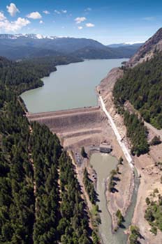
Making all this possible in a region that receives no more than eight inches of precipitation a year is the Bureau of Reclamation’s multi-faceted Yakima Project, which irrigates a narrow, 175-mile strip on both sides of the Yakima River, a tributary of the Columbia. Tieton Dam (pronounced Tie-it-ton), 40 miles west of the city of Yakima, is just one of several dams on the project, but it stands out. When completed in 1925, Tieton was the highest earthfill dam in the world. The Yakima Project as a whole is notable as an example of how irrigation of the arid West often began with private efforts that later joined with the Federal Government to ensure agricultural growth.
The Yakima Valley is dry, but its soil, comprised mostly of volcanic ash, is deep and rich in minerals. With central Washington’s mild and sunny climate, water was all that was needed to transform this sage land into lush orchards and fields. The valley’s fertile soil and the many tributaries of the Yakima River have long figured in the region’s economy. Prior to 1852, Catholic priests built a ditch to irrigate a garden at their Indian mission on Ahtanum Creek. Other early settlers also irrigated on a small scale.
Times changed after 1884, when the arrival of the Northern Pacific Railway opened the valley to outside markets. Larger and more complex irrigation projects took root, including the important Sunnyside Canal, which served lands on the northeast side of the Yakima, from Union Gap to Prosser. The railroad was a key player in construction of the canal until the financial depression of 1893 forced it to withdraw. Work stalled until the Washington Irrigation Company acquired the project. By 1906, the Sunnyside Canal was 56 miles long, and another 47 canals and ditches ran up and down the Tieton, Naches, and Yakima rivers, irrigating a total of 150,000 acres. So successful were these private irrigation efforts that farmers in the Yakima Valley were touted, historian Christine Pfaff writes, “as among the most prosperous in the West.”
Trouble brewed, however, when it became apparent that water in the valley was over-appropriated. With irrigation companies desperate to meet demands, tensions ran so high in 1905 that the Washington Irrigation Company blew up a storage dam built by the newer Union Gap and Irrigation Company. As early as 1903, landowners organized and got up a petition urging the newly formed U.S. Reclamation Service (today’s Bureau of Reclamation) to get involved in the valley’s water issues, which Reclamation did by sending engineers to Washington state.

When the engineers recommended expanding and enlarging the Sunnyside Canal, Reclamation purchased the canal and its lateral system from the Washington Irrigation Company for $250,000. Reclamation, a Federal agency, thus expanded on work already begun by private enterprise. On December 12, 1905, Secretary of the Interior Ethan Hitchcock approved the Yakima Project and, within 35 years, Reclamation constructed six storage dams and three diversion dams, including one diversion dam in the picturesque Tieton River Canyon.
The canyon, formed by the Tieton River as it rushed down from its headwaters on the Eastern Slope of the Cascade Mountains, seemed an ideal place to build another storage dam and reservoir, which would furnish water to irrigate an additional 100,000 acres of project lands. In 1917, with the summit of Mount Rainier in the distance, Reclamation engineers began building Tieton Dam in a narrow gorge of the Tieton River Canyon. Ponderosa pines and intriguing basalt formations towered above the river as a construction camp took shape to house and feed a labor force that, at its height, reached 570 men. Workers were digging a tunnel to divert the river around the dam site when World War I brought a sudden halt to construction. Work did not resume until 1921 with Reclamation personnel taking the lead, but letting small contracts to others to cut and clear 2,700 heavily timbered acres.
When completed four years later at 321 feet high, Tieton Dam was the highest earthfill dam in the world. Its concrete core wall is anchored in solid rock nearly 100 feet below the riverbed, as well as on its abutments. As Pfaff and David W. Harvey explain, engineers used mining methods to excavate the core wall, digging shafts, then cutting horizontal cross tunnels and filling them with concrete. The finished core was five feet thick at its base, tapering to one-foot thick at the top. The dam’s embankment was comprised of earth, gravel, and boulders excavated from nearby borrow pits, hauled on trestles and dumped at the site. Jets of water from high-pressure hoses separated and pushed the smaller material of sand and silt against the core wall, leaving the coarser material near the outer faces.
Two of the foremost engineers in water development in the West were involved in the construction of Tieton Dam; Frank Crowe later would be superintendent for construction of Hoover Dam, and Frank Weymouth would become chief engineer for the Bureau of Reclamation.
Tieton Dam and its 10-mile-long Rimrock Lake are part of a Yakima Project that today comprises six storage dams and reservoirs, five diversion dams, 416 miles of canals, 1,698 miles of laterals, 30 pumping stations, 144 miles of drains, two powerplants and 73 circuit miles of transmission lines. The Yakima Project, encompassing 464,000 acres, is divided into seven divisions: Storage, Kittitas, Tieton, Sunnyside, Roza, Kennewick, and Wapato, the latter of which is operated by the Bureau of Indian Affairs. More than 45,000 acres not included in the seven divisions are irrigated by private interests under contract with the Bureau of Reclamation.
Visit the National Park Service Travel Bureau of Reclamation's Historic Water Projects to learn more about dams and powerplants.
Last updated: January 13, 2017
