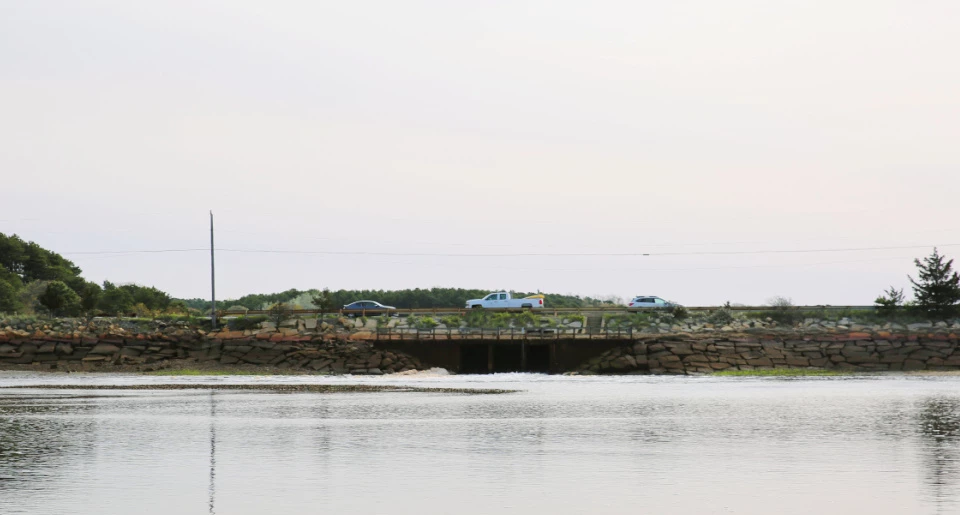
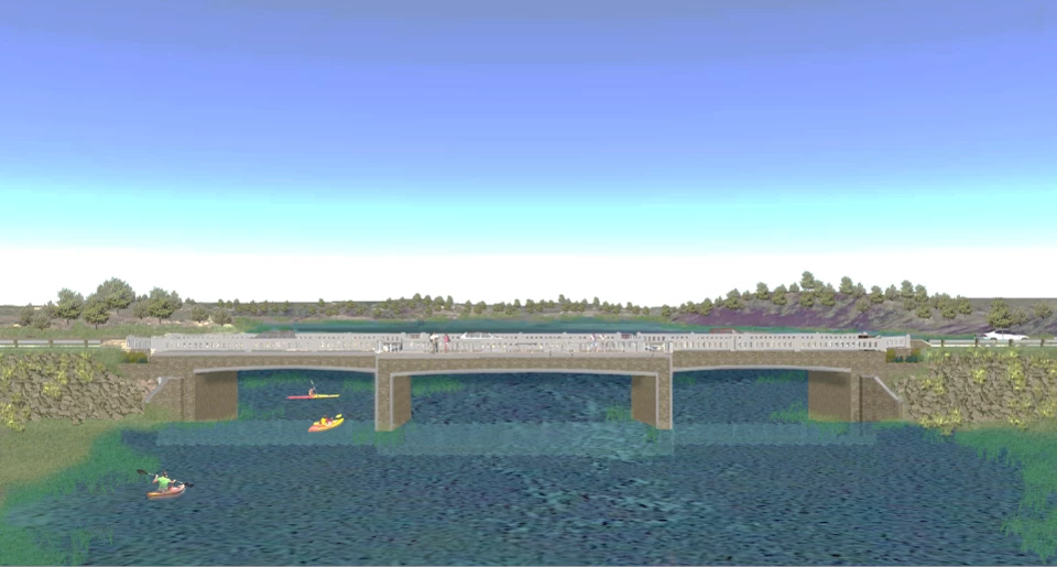
Current View of Chequessett Neck Dike and Rendering of Final Bridge Design
The image on the left shows the current dike as built in 1909 and the right image shows the rendering of the final project design of the bridge when the tide gates are fully open. NPS Photo/Kristin Vinduska and NPS Graphic
After many years of research and study the Herring River Restoration Project (HRRP) is underway. Working in partnership with the Town of Wellfleet, the tidally-restrictive dike at the mouth of the river is being replaced with a bridge that will allow tidal water to flow freely between the river and Wellfleet Harbor. Increasing tidal flow will also bring saltwater back to the river and return it to the thriving and ecologically productive estuary it was for thousands of years before the dike was built. The vegetation will change to a mix of salt and brackish water loving plants typical of New England salt marshes. River herring will return to once again spawn in Herring, Higgins, and Gull Ponds, the kettle hole ponds that are the headwaters of the watershed. Other culverts and roadcrossings throughout the Herring River floodplain will be replaced to make it easier for herring and other fish to move throughout the river and improve habitat for other wildlife.
Tide gates built into the bridge will be opened gradually over several years so that conditions can be monitored closely. Scientists from Cape Cod National Seashore (CACO) and other groups are studying tidal hydrology, water quality, vegetation, sediment transport, and a host of other variables to evaluate the effects of the project. As planning for the project was conducted, significant efforts were made to anticipate and clearly define the expected benefits of restoring tidal flow. If unexpected or undesirable conditions are documented, tide gates can be managed to address any problems and avoid harmful effects.
The HRRP is overseen the Herring River Executive Council, including representatives from CACO and the Wellfleet Selectboard, with input from a stakeholder group representing local concerns and interests and financial and technical support provided by wetland restoration experts from the U.S. Fish and Wildife Service, Natural Resources Conservation Service, National Oceanic and Atmospheric Administration, Massachusetts Divsion of Ecological Restoration, the National Park Foundation, and the Friends of Herring River.
Project Benefits
The Chequessett Neck Road dike at Herring River is causing drainage of the salt marsh and poor tidal flushing. Drainage of the salt marsh leads to prolonged exposure to air causing the salt marsh soils to decompose and release sulfuric acid into surrounding soils. When disturbance by activities like maintaining mosquito ditches, these soils leach toxic acidity and aluminum into the remaining surface water. Before the National Park Service asked the Barnstable County Mosquito Control Project to cease work in mosquito ditches, acidic water was linked to the death of thousands of American eels, river herring, and other aquatic animals. Poor tidal flushing is causing the depletion of dissolved oxygen in the water. Dissolved oxygen enables aquatic animals to breathe. The dissolved oxygen in the Herring River sits at dangerously low levels as it is today. Without tidal flushing, fecal coliform bacteria have been concentrating at the river's mouth. Due to the high bacteria levels, the Massachusetts Division of Marine Fisheries has closed acres of productive and otherwise harvestable shellfish beds in both the river and Wellfleet Harbor.
The water quality of the Herring River and Wellfleet Harbor will be substantially improved with the restoration of tidal flushing and the salt marsh. Infusions of oxygen-rich water from Cape Cod Bay and Wellfleet Harbor will occur twice daily providing more oxygen for the system. Tidal flushing will reduce bacteria loading by dilution and high salinity, which shortens the lifespan of the bacteria. Tidal restoration also will buffer acidity contamination by resaturating wetland soils with salt water. Along with higher high tides, there will be lower low tides that will improve drainage of ponded mosquito breeding sites on the wetland surface. Restoration will lead to improved habitat conditions for many microorganisms, shellfish, finfish, and wildlife. Restoring the natural connection between salt marshes and coastal waters is critical for the nutrients, sediment, and marine life between the ocean and highly productive estuarine habitats.
The Chequessett Neck Road dike at Herring River substantially reduced tidal exchange, reducing the area being flushed with salt water. Over time, the salt marsh turned into a freshwater marsh, completely changing the natural landscape for those creatures that depended on it. Freshwater marsh vegetation started to grow where salt marsh vegetation could no longer survive. Within our lifetimes, large regions behind the dike have progressed rapidly from a marsh to open meadow to an upland forest ecosystem. Invasive non-native plants have taken over along with dying shrubs and trees. One of these species is common reed, a tall invasive reed grass that has negative effects on salt marsh ecosystems. It displaces native species, reduces biodiversity, chokes waterways reducing flood retention, and offers little value for wildlife. If no action is taken, continued forest and shrub growth and expansion of invasive common reed will displace the more open, herbaceous habitats in the upper part of the system that are relied upon by many species. Restored salinity will kill many of the salt-sensitive exotic plants that have invaded the floodplain and create favorable conditions for salt marsh vegetation to return.
Salt marshes at Cape Cod National Seashore are vulnerable to climate change and sea level rise. Restoring a native salt marsh at the Herring River will provide a place for this critical habitat to exist once again. Salt marshes are among the most biologically productive ecosystems on earth and play an important role in filtering out nutrients and protecting from storm surges. Salt marshes serve as critical habitat for a host of important animal species including fishes, shellfish, and birds. Saltmarsh sparrows, for example, are a declining species and state species of special concern that are completely reliant on this habitat for breeding. Diamond-backed terrapins, a state threatened species, will also benefit from the restoration as it will expand their foraging, mating, and nesting habitat by more than 750 acres. Small and large mammals will also be able to utilize foraging on salt marsh vegetation and the habitat it provides. Salt meadow cordgrass is a valuable forage plant for white-tailed deer. Northern harriers, a state threatened species, and other raptors will have a hunting ground for meadow voles that inhabit the salt meadow cordgrass. The Herring River Technical Team, including CCNS staff, has developed a Habitat Management and Monitoring Plan that describes changes to species and habitats currently inhabiting the project area in more detail.
Historically, the Herring River supported a thriving coastal river ecosystem and one of the largest nurseries for recreational and commercial fisheries in the Gulf of Maine. Records from the town of Wellfleet in the 1800’s report that more than 200,000 river herring were netted annually from the river. Seasonal herring counts conducted Friends of Herring River volunteers indicate the current usage of the river is an order of magnitude below pre-1909 levels. The dike’s small opening restricts water flow in and out of the upper parts of the estuary and marsh, decreasing the mean tidal range. This makes it difficult for fish to enter the river and reduces the submerged and intertidal habitat available for shelter and foraging. Over the past century, this, along with poor water quality, has made it harder for fish to successfully reproduce and survive in their original numbers. Some species, such as brook trout have disappeared from the marsh entirely.
Restoring tidal range will ensure that estuarine fish can access the salt marsh surface during the high tides and follow the tide back towards the sea during the ebb. Estuarine fish, especially killifish, consume mosquito larvae. Restoring their habitat would reduce mosquito breeding. Unrestricted tidal exchange also allows for a natural passage of migratory fish, like river herring, eels, and white perch, that must travel between salt and freshwater habitats to spawn and complete their life cycles. High tides also support the movements of many other groups of animals that regularly feed or reproduce in the marsh, from silverside minnows to lobsters, bluefish, striped bass, terrapins, and even seals and dolphins. The restored tidal range yields ebbing tidal waters, high in plant nutrients and organic detritus from the creek sediments and marsh, to enrich near-shore waters and feed resident shellfish and finfish. Nitrogen exports from marshes in the form of ammonium used by phytoplankton and the organic detritus coated with nutritious microscopic life are beneficial to the food webs of shellfish. Reestablishment of tidal range will restore favorable conditions and restore physical access to habitats for finfish and shellfish.
Sediment cores retrieved from the Herring River system indicate that it had been a stable salt marsh for approximately 2000 years. The presence of salt water in the system, inhibiting freshwater plant colonization and the balance between deposited sediment and the slow rise of sea level driven by glacial meltwater maintained this salt marsh ecosystem. Today, the Herring River system is a heavily impaired area. A natural unaltered salt marsh can compensate for gradual rise in sea level through the deposition of organic material layered with sediments washed into the marsh system on flood tides. The Herring River dike blocks the influx of inorganic sediments (sand and silt), handicapping the marsh’s ability to compensate for rising sea level. After dike construction, decaying organic matter became the dominant remaining marsh deposit.
After the salt marsh was ditched and the river channelized for mosquito control the discharge of water to the sea from the marsh increased and organic deposits (peats) began to dry out and shrink. The pore space between grains of sediment and organic debris had been supported by water, but as the peats dried out these pores collapsed under their own weight, and the marsh surface sank still more. In the drained section of the marsh, organic material was exposed to the air and began to decompose more quickly, also contributing to subsidence. Presently, the restricted marsh surface elevation upstream from the dike is about 70 cm (over two feet) lower than the natural marsh surface just downstream. A casual observer can note the differing elevations from the hill above the dike, as well as the large difference in tidal range.
Restored tidal range leads to higher sediment transport and deposition onto the wetland surface, as sediment-carrying flood tides again flood over creek banks and onto the marsh plain. This surface has subsided over the past 100 years of diking; therefore, restored sedimentation can allow the wetland surface to rise, reducing inland erosion, trapping sediment, and increasing storm-surge protection for roads and other structures at the edge of the floodplain. Flood tides, and especially storm tides, over time transport massive amounts of sediment onto the marsh surface, helping it to rise and keep above the rising sea level. This sediment also promotes the growth of salt marsh grasses that convert solar energy and carbon dioxide to organic matter at rates almost unmatched on this planet.
Blue carbon refers to the carbon stored in wetlands and seagrass beds. These natural habitats store massive amounts of carbon and prevent carbon dioxide loading to the atmosphere. Decomposition in waterlogged, oxygen-poor salt marsh peat is slow and turnover time of the stockpiled carbon is long – thousands of years. Wetlands store carbon at a rate many times faster than even tropical forests, well known for their carbon-storing abilities. Carbon storage is one of many reasons that makes coastal wetland protection and restoration vital. The degraded ecosystem has emitted an estimated 730,000 metric tons of carbon dioxide into the atmosphere since the dike was built in 1909. The Herring River Restoration Project presents a unique opportunity to achieve greenhouse gas benefits from a large-scale tidal wetland restoration.
Research led by the United States Geological Survey in Woods Hole, Massachusetts in partnership with Cape Cod National Seashore and other colleagues indicates that the compromised diked and waterlogged wetlands are significant sources for human-caused methane, a greenhouse gas with global warming potential 40 times that of carbon dioxide. Methane emissions from the Herring River are nearly 15 times higher than those in natural marshes. Restoring saltwater inundation is expected to largely eliminate methane production. The USGS used published information on changes in greenhouse gas emissions and on expected changes in acreage of salt marsh due to restoration to estimate the change in greenhouse gas exchange between the ecosystem and the atmosphere. The salt marsh is expected to increase by 677 acres, which will bring about a great variety of environmental benefits. The marsh will reduce greenhouse gas emissions at an astonishing rate. Calculations are that 4,018,572 grams of carbon dioxide equivalents per acre per year will be reduced. Projecting forward, this equates to a decrease of 2,721 metric tonnes of carbon dioxide equivalents per year which translates into a total reduction of 81,633 metric tonnes per every 30 years the project is ongoing. This thirty-year benefit can be illustrated by the following statistics. In terms that equate to current events, this project will equal avoiding burning 90 million pounds of coal. The project benefits can further be likened to avoiding burning 9.3 million gallons of gasoline or avoiding logging 551 acres of forest. On a proactive basis, it would equate to operating 22 average wind turbines for a full year! The magnitude of the benefits of the Herring River Restoration Project is indeed comprehensive in scope and provides environmental benefits for many years to come.
The Herring River runs from Wellfleet Harbor northeast about four miles to Herring Pond in north Wellfleet, and northwest a similar distance to Ryder Beach in south Truro, covering nearly 1,000 acres. Before the Herring River was subjected to ditching, channelization, and diking, it supported a vibrant coastal river ecosystem including estuary and salt marsh habitats. This natural system has been impaired since 1909 but the Herring River Restoration Project seeks to restore it for the benefit of future generations, including all who call it home and recreate there.
Restoration means better boat access throughout the Herring River estuary with returned tidal exchange allowing higher high tides to give access to open marsh instead of the drained shrub thicket that exists today. It also means reducing invasive species like common reed (Phragmites australis) and nuisances like mosquitoes. The Herring River can once again be a place to find extensive, abundant and diverse marine resources for observation, education, and harvest both within the estuary and the nearby coastal waters. The completion of this project will serve as a model for restoring other estuaries in Massachusetts and along America’s coasts. The Herring River is a natural asset and once it is repaired, people can continue to enjoy the scenery and recreation it has to offer for generations to come. To learn more about the Herring River, the restoration project, and opportunities to attend education and recreation programs, check out the Friends of Herring River website.
Project Area and Elements
Two maps show the Herring River project area. The map on the left has labels for siginificant locations within the project area including Upper Bound Brook, Lower Bound Brook, Upper Herring River, Mid Herring Riiver, Duck Harbor, Lower Pole Dike Creek, Lower Herring River, Mill Creek, and Upper Pole Dike Creek. An area highlighted in blue shows the extent of the monthly mean spring tides. A red outline shows the full project area and a green outline shows the Cape Cod National Seashore (CCNS) boundary. The map on the right shows the same area with same blue highlighted area and outlines. This map describes the project elements including elevating low roads, enlarging Bound Brook Road culverts, building Pole Dike Creek Water Control Structure, removing High Toss Road, building the Mill Creek Water Control Structure, and building the Chequessett Bridge. NPS Maps
Project Elements
The Herring River Restoration Project (HRRP) includes many complex elements to achieve the goals of this project. This consists of public infrastructure construction projects, vegetation management, and restoration of natural salt marsh elevation and hydrology. Reintroduction of tidal flow is a phased process that will occur over several years. The primary reasons to implement the project in this manner are to avoid unexpected or sudden irreversible changes to the river and Wellfleet Harbor and to allow monitoring of the system so that unexpected and/or undesirable responses can be detected, and appropriate remedial actions taken.
Computer simulations (i.e. modeling) of the current and future conditions of the river, form the basis of design requirements for the overall restoration program, including the need for infrastructure modifications and protection of existing infrastructure and structures from restored tidal flow. The hydrodynamic modeling is a computerized simulation of the flow direction, velocity, duration, and depth within the river driven by tides in Cape Cod Bay, wind, rain, and external conditions, and the configuration of water control structures (i.e. tide gates). The primary design objective is to facilitate natural tidal hydrology within the river while protecting roads and structures from regular and storm-driven tidal impacts.
These summaries and more information, including detailed engineering plans, can found in the permit application narratives on the Friends of Herring River website: Friends of Herring River Restoration Project Updates.
The Chequessett Neck Road dike crosses the Herring River between the mainland of Wellfleet and Griffin Island. The earthen dike has impeded tidal exchange in the Herring River since 1909 when it was constructed. Replacing the dike with a bridge and new water control system is the primary construction element of the restoration project. The dike and the three 6-foot-wide culverts are being replaced with a new 165-foot-wide bridge and electronically controlled tide gates that can be vertically opened. The new bridge and incremental opening of the gates will allow for the gradual transition from restricted tidal flushing to conditions more closely resembling the Herring River’s natural flow prior to the dike’s construction. Restored natural flow facilitates tidal exchange over hundreds of acres of the Herring River estuary.
The bridge and tide gate design was selected following an alternative analysis of possible structural options to replace the existing dike and to determine which would be best suited to achieve the restoration objectives. Based on this analysis, a new pre-cast box beam bridge structure equipped with adjustable tide gates and removable panels was selected as the preferred design concept. The new bridge will also include enhanced parking, pedestrian access, and viewing/fishing platforms, improved stormwater management, and improved aesthetics from burial of overhead utilities. The addition of public water access facilities was also included to provide safe portage of hand-carried recreational watercraft between Wellfleet Harbor and Herring River. The public access will entail an ADA-compliant access from a new Duck Harbor Road parking area with stepped access structures from the bridge.
The Herring River Restoration Project includes restoration of the Mill Creek sub-basin. Mill Creek is in the town of Wellfleet, where it flows along to eventually meet the Herring River just upstream of the Chequessett Neck Road bridge. A water control structure equipped with vertically adjustable tide gates will be constructed across Mill Creek near the entrance to Lower Herring River. This structure enables a controlled re-introduction of tidal exchange while protecting structures on private properties. The structure extends approximately 520 feet across Mill Creek; the design contains five culverts or openings, each five feet wide, for a 25-foot-wide opening in total. These openings are outfitted with adjustable tide gates. If warranted, the gates can be closed to inflowing tidal water, while still allowing freshwater to drain out of Mill Creek.
Over the millennia of human habitation on outer Cape Cod, people have needed to find and construct ways to access and cross over the Herring River to access Griffin and Bound Brook Islands and to get to the river itself for fishing and other activities. Many of these structures still exist and are planned for removal or modification as part of the HRRP. In more recent times, roadways were constructed for vehicle use along the edge of the floodplain and several low segments will require elevation for their continued use. The following is a summary of road modifications that are part of the HRRP.
Pole Dike Road
Pole Dike Road runs along the eastern edge of the Herring River floodplain, connecting West Main Street and Bound Brook Road. Pole Dike Creek, a small tributary of the Herring River, passes under the road near the Wellfleet Transfer Station. This section of Pole Dike Road is very low and needs to be elevated to accommodate restored tidal exchange. A new larger culvert will also be installed for improved flow. However, the tide gate will be managed by the Town of Wellfleet to only allow freshwater flow toward the Herring River. No tidal flow will be allowed upstream of the road until agreements are finalized with owners of land that could potentially be affected. The design at Pole Dike Road is to raise the roadway at the crossing by about 4 feet and to increase the size of the culvert from a 36-inch diameter pipe to an 8-foot-high by 7-foot-wide box culvert with a combination flap/slide gate.
High Toss Road
High Toss Road is an approximately one-mile sand road that starts from Pole Dike Road near the Town’s stump dump and crosses the Herring River just east of Griffin Island. At that point the river flows through a 5-foot diameter concrete pipe. The road has two sections, a drivable one and an undrivable one. The drivable section extends to the intersection of Way 672. The undrivable section continues another 1000 or so feet to the end of the road just past the Herring River. The drivable section has several low segments that would be flooded by restored tides, Segments beyond Hopkins Drive will be elevated and graded to avoid flooding and allow uninterrupted vehicle access to homes along Way 672. Road segments between Hopkins Drive and Pole Dike Road will not be elevated and may be wet and impassable during some tidal conditions. The undrivable section, between Way 672 and Griffin Island has been abandoned by the Town and will be completely removed from the Herring River floodplain. The culvert currently carrying the Herring River will be removed and the natural channel cross section will be restored. No new accommodations for pedestrian access are planned. Completely removing this section of High Toss Road will ensure adequate tidal circulation in this part of the HRRP area.
Bound Brook Road
Brook Road connects Pole Dike and Old County Roads and has the longest section of low areas within the HRRP area. Just under a mile of the road will be elevated between the Wellfleet Transfer Station and Pamet Point Road. Most of the road would be elevated 3-4 feet to protect it from tidally driven flooding during a severe coastal storm. In addition, the small culvert carrying the Herring River, near the Atwood-Higgins property, will also be replaced.
Old County Road
Old County Road runs from Pamet Point Road and into Truro. The intersection with Ryder Beach Road, in Truro, marks the northern limit of the HRRP area. The road contains 5 short segments associated with drainage culverts that will be elevated. Three of these are in Truro. Culverts will also be replaced.
The seven culverts being replaced in conjunction with elevation of low-lying roadways are currently non-tidal but will eventually be affected by tidal exchange at full restoration. The replacement culverts are sized to accommodate the increased amount of flow anticipated at full restoration; their collective design conforms with the recommendation in the Massachusetts Stream Crossing Standards by using a watershed-based approach to maximize positive outcomes and avoid unintended consequences. The replacement crossings adhere to stream crossing guidelines to the extent feasible to provide for fish passage, stream continuity, and wildlife passage.
The HHRP includes protection of low-lying property within the restoration project area. This includes elevation and grading of driveways relocating private water supply wells, and other measures to project structures built within the Herring River floodplain. .
In addition, a detailed plan for modifications to the golf course at the Chequessett Club has been developed. Currently, portions of golf course experience occasional flooding by groundwater and surface water in the area of Mill Creek; under certain conditions and absent mitigation measures, this could be affected by the HRRP. To address this, the plan would enable the restoration project to succeed while protecting the golf course from potential adverse impact.
As tidal range is restored within the HRRP area, salt water will cause mortality to the herbaceous and woody freshwater-dependent and upland species that have colonized the floodplain. If left standing, stressed and dead trees and shrubs could hamper the recolonization of desired native salt marsh plant communities. Potential detrimental effects include shade in areas where full sun is needed to support recolonizing salt marsh grasses and suppressed water circulation by failing limbs and accumulated woody biomass. Recolonization of salt marsh plants could also be impeded by branches and debris smothering marsh soils. The combination of all these effects – standing dead trees and dead branches over unvegetated, poorly drained marsh surfaces – could constitute a landscape that many find aesthetically objectionable. In areas currently dominated by herbaceous, emergent plant species, the non-native, invasive common reed (Phragmites australis), and possibly other non-native species, could expand which would have a number of deleterious ecological and socioeconomic effects, including displacement of native vegetation, reductions in habitat quality, and creation of freshwater mosquito breeding habitat.
Active removal and management of vegetation will be limited to three broad cover types: 1) the common reed component of the emergent marsh, 2) shrublands, and 3) woodlands. Existing areas of salt marsh and native emergent freshwater marsh are not expected to require active vegetation management to achieve project objectives and will generally be allowed to remain or transition passively into tidal wetland plant communities, with the exception of areas where common reed, or other invasive species, could potentially colonize.
Although reintroduction of tidal exchange and salinity is the primary component and main driver for restoration of the Herring River floodplain, several other actions are necessary to reverse previous direct and indirect alterations of the system’s topography, bathymetry, and drainage capacity. After tidal restoration is initiated, these factors could inhibit circulation of saltwater, prevent recolonization of tidal marsh vegetation, create freshwater impoundments, and expand mosquito breeding habitat if not properly managed. The primary issues to be addressed through marsh management are:
Lowering of the marsh surface: Areas of the Herring River are currently up to three feet lower than similar saltmarsh elevations around Cape Cod Bay relative to current sea level. This is the result of three factors: 1) drainage, compaction and erosion of saltmarsh peat, 2) lack of sediment supply to maintain marsh elevation, and 3) on-going sea level rise in Wellfleet Harbor. At the current elevations with tidal flow partially or fully restored, these areas would not support saltmarsh vegetation communities and would not drain properly.
Sediment trapped in marsh channels: Lack of tidal flushing for more than 100 years has allowed the accumulation of sediment and organic matter in former tidal channels and ditches throughout the floodplain. Normally this material would be distributed and deposited on the marsh plain by tidal flow or remain part of the suspended sediment load of the tidal prism flowing between the river and Wellfleet Harbor. With tidal exchange restored, this trapped sediment could cause obstructions to flow in some locations, especially during early stages when flow velocity may not be powerful enough to mobilize material.
Historic grid ditching, channelization, water-logged soils: Like most tidal wetlands in New England, the Herring River floodplain has been dramatically altered by grid ditches created and maintained by regional mosquito control programs since the early 20th century. Many stretches of the Herring River have also been channelized to drain the marshes. Ditching and channelization have re-routed the flow of water throughout the floodplain, resulting in drained soils in some locations and continuously saturated, waterlogged soils in others. Extensive marsh ditching has also contributed to greater marsh surface subsidence in some locations.
Spoil piles: As a customary practice, when channels and mosquito ditches were created or maintained, the dredged sediment (aka “spoil”) was disposed of in linear mounds immediately adjacent to the channel being worked on. These spoil piles are frequent along the river and channels and in some places are identifiable by topographic mapping. With tidal exchange restored, spoil piles could block the circulation of saltwater and impede drainage.
As part of a partnership with the U.S. Fish and Wildlife Service, Ducks Unlimited and the project team, CACO is developing a pilot project within a portion of the HRRP area to evaluate methods for marsh restoration. Spoil berms created by mosquito control and stream channelization work in the 1920s will be excavated dredge spoils from berms. Material will be deposited in subsided locations in order to rebuild marsh elevation appropriate for inter-tidal conditions and establishment of salt marsh vegetation. Upon completion of berm excavation and grading, tidal gates at the new Chequessett Bridge will be partly opened to provide tidal salt water to the excavated and graded areas. Salt marsh vegetation is expected to recolonize over a 2-3 year time period. The areas will be extensively monitored for recovery of ecological functions and results will be used to inform the design and completion of additional berm removal and grading projects in other parts of the restoration project area.
Vegetation clearing for Duck Harbor and the surrounding areas has been completed for 2024.
NPS
Project Updates
Mill Creek Water Control Structure
Construction on the Mill Creek water control structure has begun and is expected to be completed in early to mid 2025. Project-specific updates related to that work can be found here.
Vegetation Management
Vegetation clearing has been completed for the year at Duck Harbor and surrounding areas. There will be other areas selected to begin clearing next year.
Regulatory Oversight Group
Herring River Restoration Project (EEA Number 14272)
Wellfleet, MA
The Regulatory Oversight Group for the Herring River Restoration Project will meet virtually on Monday, January 6, 2025, at 2 pm via Zoom. Members of the public can participate in the meeting by using the following link:
The Regulatory Oversight Group (ROG) was established in accordance with the Certificate of the Secretary of Energy and Environmental Affairs on the Final Environmental Impact Report for the Herring River Restoration Project (EEA Number 14272). The Regulatory Oversight Group consists of representatives of local, county, state and federal agencies and the Mashpee Wampanoag Tribe. The Herring River Restoration Project is being undertaken by the Town of Wellfleet, MA and the National Park Service Cape Cod National Seashore. Phase 1 of the project is currently being implemented and upon completion will restore 570 acres of former tidal wetlands. The agenda for the January 6th meeting is below.
3. Marsh Management Pilot Projects – Tim Smith, Restoration Ecologist, Cape Cod National Seashore
• Berm Removal Pilot Project
• Mill Creek Salt Marsh Restoration Pilot Project (with Kevin Kroeger, Supervisory Research Chemist, US Geological Survey)
Last updated: January 16, 2025
Park footer
Contact Info
Mailing Address:
99 Marconi Site Road
Wellfleet,
MA
02667
Phone:
508-255-3421
To contact NPS Law Enforcement or report an incident, please call the 24-hour dispatch: 617-242-5659. In the event of an emergency, call 911.