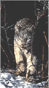
Lynx (Felis lynx canadensis) were reported in the park in the early years of this century. Bailey (1927) reported that "there are said to be a very few Canada lynxes, but we saw no tracks or signs of them," during a July 1926 outing in Yellowstone backcountry by more than 200 Audubon Society members. Skinner (1927) estimateda lynx population of 10 with stationary status. By the mid-1940s, lynx were reported as extremely scarce. Annual reports of wildlife in the park list lynx as a "rare native" in the late 1960s, but in the early 1970s this animal was not listed as present. In 2001, park biologists initiated a park wide study of lynx habitat with the hopes of documenting this recently listed species. In 2002, lynx sign in the form of DNA and tracks were found in Yellowstone, confirming at least that lynx are transient in the ecosystem.
Habitat ModelingTo better understand lynx and to determine where populations might exist, the spatial analysis center created a habitat model using vegetation criteria based on information from biologists studying lynx throughout the Rocky Mountains. The habitat model was created in ArcGIS using the spatial analyst extension. The grid that resulted from using the map calculator, enables biologists to focus lynx monitoring efforts.
Suitable Lynx Habitat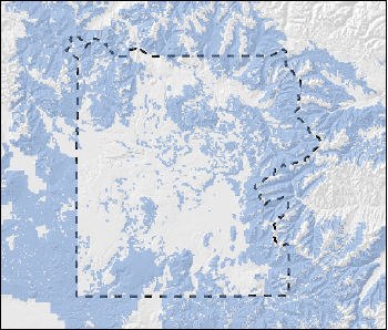
 Suitable Lynx Habitat
 Yellowstone Boundary
 LAU with less than 30% Lynx habitat
 Suitable Lynx Habitat
 LAU with 30% or more Lynx habitat
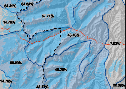
Based on regulations required by the Fish & Wildlife Service, the level 5 hydrologic unit boundaries (HUC's) delineate the lynx analysis units(LAU_s). A HUC becomes a LAU when at least 30% of the HUC is suitable lynx habitat. This is a great application for GIS. We used the zonal statistics function in ArcGIS spatial analyst. The resulting table was joined to the HUC_s layer and the percent of suitable habitat was calculated using the following equation: % Lynx habitat = Area of HUC / (grid cell count (from habitat model)* 10000) *100.
The data was in meters and the grid cells are 100 by 100 meters in size so each cell counted equals 10000 square meters. See map 3 for an example of this calculation.
Lynx Analysis Units in Yellowstone National Park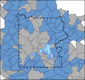
 LAU with less than 30% Lynx habitat
 LAU with 30% or more Lynx habitat
Biologists in Yellowstone National Park are using this information to conduct field inventories for lynx and other rare carnivores. They hope to identify what activities in the park have adverse consequences on these rare and elusive species. For example, ongoing road construction on the East Entrance road could alter suitable habitat for lynx. Using CAD drawings from the road engineers and lynx habitat model (shown in map 1) we calculated the amount of habitat affected.
Yellowstone Spatial Analysis Center - ben_dorsey@nps.gov