News Release
You are viewing ARCHIVED content published online before January 20, 2025.
Please note that this content is NOT UPDATED, and links may not work. For current information,
visit https://www.nps.gov/aboutus/news/index.htm.

NPS
|
Subscribe
|
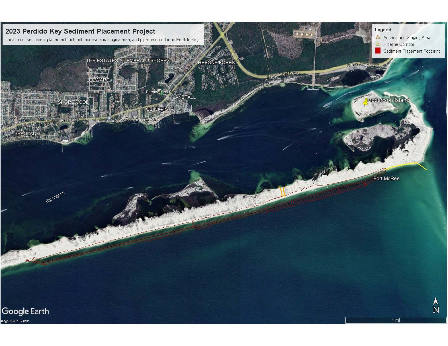
In preparation for mobilization, heavy equipment, and materials can already be seen on and near Perdido Key. A cutter dredge and hydraulic pipeline will be used to excavate the channel to a maximum depth of 39 feet. Through an interagency partnership between USACE and the National Park Service (NPS), approximately 1.7 million cubic yards of the dredged sediment will be placed on land and nearshore on Perdido Key from the eastern end of Johnson Beach Road to the eastern tip of Perdido Key Island.
All sediment being removed is considered beach-compatible material and will be placed in a manner that mimics the natural topography of Perdido Key. Sediment placement on Perdido Key is expected to offset shoreline erosion, restore sediment to the natural sediment transport system, and create additional wildlife habitat.
NPS staff will be conducting required onshore wildlife monitoring and assisting with archaeological monitoring before, during, and following all sediment placement activities, including equipment mobilization and preparation. Crews are required to finish sediment placement and demobilize by Feb. 14, 2024, to avoid impacts during the shorebird nesting season, which begins Feb. 15.
For public safety, project areas where heavy equipment is stored or being operated will be closed to the public and regularly patrolled. The project area includes an approximately 4-mile sediment placement footprint, a pipeline corridor, and a deep-water access point on the north shore, see attached map. All closed project areas will be identified with bright orange construction fencing and will move as the project progresses along the 4-mile placement footprint. Placement will start on the eastern end of the placement footprint and progress west.
Visitors to Perdido Key and the surrounding areas may notice heavy equipment on Robertson Island, a dredge material island to the north of the eastern tip of Perdido Key. This equipment is conducting maintenance to Robertson Island in preparation for a future maintenance dredging of the Intracoastal Waterway by USACE. The operations on Robertson Island are an independent USACE project and are unrelated to the upcoming sediment placement on Perdido Key.
Funding for the maintenance dredging of the Lower Pensacola Pass and sediment placement on Perdido Key was contributed by USACE, and by “The Perdido Key Sediment Placement Project”.
“The Perdido Key Sediment Placement Project” is a Deepwater Horizon Natural Resource Damage Assessment Restoration (NRDAR) project that is being paid for with funds provided by BP as part of a 2016 settlement agreement with federal, state, and local governments. NRDAR projects compensate the public for injuries to natural resources and the loss of the services they provide, such as recreational use.
More information about other Deepwater Horizon Natural Resource Damage Assessment restoration projects can be found at the Trustees’ web site: www.gulfspillrestoration.noaa.gov.
www.nps.gov
About Gulf Islands National Seashore: Created in 1971, the national seashore stretches 160 miles along the northern coast of the Gulf of Mexico in Florida and Mississippi, and includes barrier islands, maritime forests, historic forts, bayous, and marine habitat. Visit us at www.nps.gov/guis, on Facebook www.facebook.com/GulfIslandsNPS, Twitter www.twitter.com/GulfIslandsNPS, and Instagram www.Instagram.com/GulfIslandsNPS.
About the National Park Service: More than 20,000 National Park Service employees care for America's 425 national parks and work with communities across the nation to help preserve local history and create close-to-home recreational opportunities. Visit us at www.nps.gov, on Facebook www.facebook.com/nationalparkservice and Twitter www.twitter.com/natlparkservice.
Last updated: November 13, 2023
