NPS Photo/Andrew Hansen
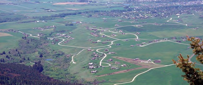
Parks may look like islands on a map, but they are not. A variety of land use activities and natural processes on neighboring lands may impact park resources, including
- deer (Odocoileus spp.), elk (Cervus canadensis), and bison (Bison bison) that migrate and feed in low-elevation grasslands both within and around the parks and often interact with human activities along travel corridors and in residential areas
- the frequency and magnitude of wildland fires
- changes in plant and animal species distributions
- fragmentation of habitat
- the introduction and spread of nonnative plants and animals
We study changes in land cover and land use over time within and around parks. This helps us understand their effects on important resources and visitor experiences in parks.
Areas adjacent to Bighorn Canyon National Recreation Area are managed by the Bureau of Land Management or the Crow Tribe. Most land surrounding Grand Teton and Yellowstone national parks is managed and protected for the public by the US Forest Service. Private lands near these park areas are widespread and intermittent, but primarily occur at lower elevations. These private lands support agriculture, transportation, residential and commercial development, recreation, resource extraction, and sometimes, conservation.
By providing park managers with information about the status and trends in human population, housing, road density, and agricultural use surrounding parks, we support more informed decision-making. Long-term study of land use and land cover around parks has other benefits as well. It lays a foundation for addressing complex issues that cross administrative and ownership boundaries, such as migratory wildlife, wildland fire, and invasive species.
In addition to surrounding land use, ongoing and future climate change is a concern for park managers. It will affect natural and cultural resource protection as well as park operations and visitor experience. Effectively managing park resources involves understanding the past climate, present conditions, and projected future change. Park managers need to understand how climate influenced the abundance and distribution of plants and animals in the past to understand how they may respond in the future. They also need to plan for climate-related events that can include more intense storms, flooding, heat waves, or drought. Any of these events may substantially affect the conditions of a park’s natural and cultural resources. They can also affect visitor health and safety.
We use publicly available, nationwide data sources and standard, repeatable methods to measure key landscape variables every few years. We provide these results to park planners, managers, and others to help them identify and address influences on park resources. The information also helps prioritize research needs for exploring how human activities, natural conditions, and natural processes affect resources within and around parks.
We Ask:
- What major land cover types occur within and around each park and how do they change over time?
- What characterizes land use around each park and how do these uses change over time?
We Track:
-
housing density
-
human population
-
agricultural uses
-
road type and density
-
areas without roads
-
land cover (vegetation types and human categories)
-
conservation status (type and degree of protection)
- climate (average long-term air temperature and precipitation, and overall water availability)
View the protocol for monitoring this vital sign.
Publications
Source: NPS DataStore Collection 4072. To search for additional information, visit the NPS DataStore.
Source: NPS DataStore Collection 4110. To search for additional information, visit the NPS DataStore.
Source: NPS DataStore Collection 7666. To search for additional information, visit the NPS DataStore.
Source: NPS DataStore Collection 9176. To search for additional information, visit the NPS DataStore.
Data Visualizers
NPS Landscape Dynamics Viewer
This viewer provides a user-friendly, interactive map to explore Landscape Dynamics data.
USGS National Gap Analysis Project (GAP) Protected Areas Viewer
The US Geological Survey’s Protected Areas Database of the United States (PAD-US) is the nation’s official inventory of public open space and private protected areas.
Great Northern Landscape Conservation Cooperative Interactive Atlas
This interactive atlas provides a point-and-click interface to evaluate economics, land use, and climate.
Datasets
NPS Landscape Dynamics Geospatial Services
Find map services for geographic information systems.
See daily precipitation and air temperature values for 67 weather stations in the Greater Yellowstone Area from 1887 through 2012.
Source: NPS DataStore Collection 5562. To search for additional information, visit the NPS DataStore.
Did you know...
We also monitor climate because of its significant influence across park natural resources.
Last updated: June 12, 2025
