NPS photo / SECN staff

NPS photo / M. Forbes Boyle
Overview
Horseshoe Bend National Military Park is comprised of 826 hectares (2,040 acres) situated in the Southern Inner Piedmont ecoregion, approximately 25 miles northwest of Auburn, Alabama. Low rolling hills, typical of the Piedmont, rise to around 220 meters (722 feet) in the southeastern corner of the park. A 5.6 kilometer (3.5 mile) stretch of the Tallapoosa River roughly bisects the park, flowing from Lake Wedowee down to Lake Martin. Hydrologic flow is controlled by R. L. Harris Dam upstream of the park. Land within the park was extensively cultivated between the 1830s and the establishment of the park in 1959. Associated agriculture, logging activities, human settlement, and introduction of non-native species helped shape the park’s vegetation communities. Following the establishment of the park, much of the land has reverted to various stages of successional forestland, mainly in mesic beech-oak-hickory in the wetter, lower-lying areas, and loblolly pine (Pinus taeda) dominated woods in the drier uplands. The understory tends to be fairly open in many forested areas, and some open fields have been maintained, mainly in the central portion of the park.
The Southeast Coast Network conducts the following monitoring at Horseshoe Bend National Military Park:
- Wadeable stream monitoring started in 2019 with one second-Strahler order stream reach in Horseshoe Bend Military Park. The stream reach was again surveyed in 2023 and is scheduled to be surveyed in 2026 . Streams in the Appalachian Piedmont region, including those within Horseshoe Bend National Military Park, are in variously altered states that reflect multiple legacies of anthropogenic disturbance. Beginning in the late 1800s, deforestation, increased row crop agriculture, and a general lack of soil conservation measures caused widespread erosion of topsoil from steeply sloped upland areas. These streams have further subjected to hydrologic alterations caused by urban or suburban development. These streams are currently recovering from their unique history of land use and seeking to equilibrate to current flow and sediment regimes. Methods used to monitor stream habitats at the park were primary bases on existing published methods from USGS, USFWS and EPA. Data are collected to assess both status and trends in upstream influences on stream habitat, changes to channel geomorphology, and benthic and instream habitat features.
- Landbird community monitoring and Vocal anuran community monitoring is conducted on a rotating schedule every three years. These wildlife communities play critical roles in park ecosystems and interact with several trophic levels of food webs. The network uses automated recording devices (ARDs) to collect vocalization data during mornings and evenings in the spring, which are analyzed by bioacoustics specialists. Data collected from these vital sign monitoring efforts help assess the ecological integrity and diversity of park areas and how communities and park conditions may change over time. The landbird and vocal anuran monitoring efforts in network parks began in 2012.
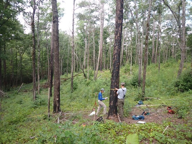
- Vegetation community monitoring is conducted on a rotating schedule. Monitoring vegetation is important because it’s key indicator of overall ecosystem health. Changes in vegetation reflect the effects of stressors like extreme weather, disease, invasive species, fire, and land use change. Plant communities also provide structured habitat and food resources for other species. Vegetation monitoring data provides managers with information about the degree of change in their park’s natural communities. Vegetation plots are established across the following habitats: Piedmont Alluvial Wetlands and Piedmont Upland Forests. Data reports include information about new occurrences and rare plants, species richness and abundance, tree health and regeneration, disturbance observations, soil nutrients, landform/geomorphology, and downed woody debris.
| Vital Signs | Examples of Measurements |
|---|---|
| Landbird and Vocal Anuran Communities | Stream channel morphology (heights, widths, depths), channel gradient, bed sediment particle size, large wood inventory, distribution of geomorphic channel units, canopy cover |
| Terrestrial Vegetation Communities | Plant community diversity, relative species/guild abundance, structure/age class, incidence of disease |
| Wadeable Stream Habitat | Channel width, depth, and gradient, sinuosity, channel cross-section, pool frequency and depth, particle size |
Source: Data Store Collection 3999 (results presented are a subset). To search for additional information, visit the Data Store.
Source: Data Store Collection 3996. To search for additional information, visit the Data Store.
Source: Data Store Collection 3997 (results presented are a subset). To search for additional information, visit the Data Store.
Source: Data Store Collection 9585. To search for additional information, visit the Data Store.
Source: Data Store Collection 4002 (results presented are a subset). To search for additional information, visit the Data Store.
Source: Data Store Collection 4000 (results presented are a subset). To search for additional information, visit the Data Store.
Source: Data Store Collection 9570. To search for additional information, visit the Data Store.
Source: Data Store Collection 3998 (results presented are a subset). To search for additional information, visit the Data Store.
Last updated: November 11, 2024
