![]()

Cover Page
MENU
![]() Poston
Poston
|
| |
Confinement and Ethnicity: An Overview of World War II Japanese American Relocation Sites by J. Burton, M. Farrell, F. Lord, and R. Lord |

|
|
| |
Chapter 10 (continued)
Poston Relocation Center
Poston II
Very little remains of the camp at Poston II. Most of the area is farm fields (Figure 10.37), and the La Pera Elementary School occupies what was once the recreation area. To the west of the elementary school, in what was the high school area, there is an auditorium, closed reportedly due to asbestos hazard (Figure 10.38). The auditorium itself is not likely a relocation center building since an auditorium is not shown on the July 1945 WRA blueprint of Poston II. However, there are a few inscriptions in a sidewalk at the auditorium, which indicate that some of the sidewalks there are remnants of the relocation center high school. The inscriptions include the numbers "221" and "229" (residential block numbers) and the initials "CK." Another inscription was found just north of Tahbo Road on the east side of the canal that ran through Poston II (Figure 10.39). On an overturned concrete block in the canal bank is the inscription "yumeda 2-12-1943" (Figure 10.40).
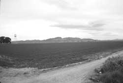 Figure 10.37. Barracks area at Poston II today. |
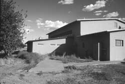 Figure 10.38. School auditorium at the site of the Poston II elementary school. |
About 1/4 mile west of Mohave road there are two concrete slabs that may be foundations of relocation center buildings. One, now with a mobile home on it, is located along the canal that bisected Poston II in what would have been the warehouse area. Measuring roughly 20 foot by 100 ft in size, the slab is aligned north-south like the warehouses were. In the net factory area there is a 30 foot by 275 foot slab with 6-1/2-foot-square base blocks about 10 feet from each corner (Figure 10.41). This slab is aligned east-west like the net buildings were.
The most visible remains of Poston II are of the sewage treatment plant, on an unnamed dirt road about -1/2 mile west of Mohave Road (Figure 10.42 and 10.43). On the east side of the highway, the former staff housing area at Poston II now has churches, residences, and a relocation center hospital ward building moved from Poston I (Figure 10.44), according to local residents. The building, lacking its double roof but otherwise in fair condition and currently being remodeled, is located behind the Poston Community Baptist Church. According to Pastor Herb Schneider, the church wants to replace or rehabilitate the structure. Another relocation center building at the church, a moved barracks, was recently torn down.


 Top
Top
Last Modified: Fri, Sep 1 2000 07:08:48 pm PDT
http://www.cr.nps.gov/history/online_books/anthropology74/ce10f.htm
![]()