On-line Book
photo album
PHOTO ALBUM


Confinement and Ethnicity:
Barbed wire divider
An Overview of World War II
Japanese American Relocation Sites

by J. Burton, M. Farrell, F. Lord, and R. Lord

clip art


Chapter 12 (continued)
Topaz Relocation Center

Outlying Features

Frm house at the Topaz Chicken Farm
Figure 12.29. Frm house at the Topaz Chicken Farm.
Collapsed laying houses at the Topaz Chicken Farm
Figure 12.30. Collapsed laying houses at the Topaz Chicken Farm.
Laying house at the Topaz Chicken Farm
Figure 12.31. Laying house at the Topaz Chicken Farm.
Adobe wall at the Topaz Chicken Farm
Figure 12.32. Adobe wall at the Topaz Chicken Farm.
Building remains at the Topaz Turkey Farm
Figure 12.33. Building remains at the Topaz Turkey Farm.
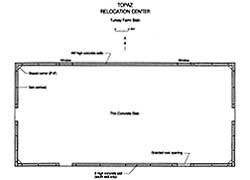
Plan map of building remains at the site of the Topaz Turkey Farm
Figure 12.34. Plan map of building remains at the site of the Topaz Turkey Farm.
(click image for larger size (~35K) )


Return to Text Next Next


Top


Last Modified: Fri, Sep 1 2000 07:08:48 pm PDT
http://www.cr.nps.gov/history/online_books/anthropology74/ce12d1.htm

National Park Service's ParkNet Home