![]()

Cover Page
MENU
![]() Tule Lake
Tule Lake
|
| |
Confinement and Ethnicity: An Overview of World War II Japanese American Relocation Sites by J. Burton, M. Farrell, F. Lord, and R. Lord |

|
|
| |
Chapter 13 (continued)
Tule Lake Relocation Center
Outlying Areas
Sewage Treatment Plants and Landfill
Both sewage treatment plants contain the remains of the large multi-chambered concrete Imhoff tanks, measuring approximately 54-1/2 feet by 63 feet by 21 feet high (Figures 13.83 and 13.84). The sludge bed location at Plant No. 2 is indicated by a low berm. Plant No. 1, north of the central area, is owned by the Newell County Water District. Plant No. 2 is located east of the central area.
 Figure 13.83. Imhoff tank at Sewage Treatment Plant No. 1. |
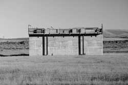 Figure 13.84. Imhoff tank at Sewage Treatment Plant No. 2. |
The relocation center landfill is on Bureau of Reclamation land northeast of Sewage Treatment Plant No. 2. It includes at least six parallel trenches with abundant burned and unburned trash (Figures 13.85-13.87). A wide variety and large number of artifacts include large cow bones, abundant glass fragments (food jars, "Coke" bottle fragments from Pittsburg, CA, Bend, OR, and Klamath Falls, OR, and "Mt. Lassen Soda"); hotel ware ceramics fragments (with "Bauer," "Hall," "tepco," "usqmc," and "V" basemarks), and some Japanese ceramics (Figures 13.88 and 13.89). Northeast of the trenches, a dense concentration of hotel ware ceramic fragments likely marks a disposal pit (Figures 13.90 and 13.91).
The landfill and surrounding area includes abundant post 1940s trash; for example, bottle dates at the landfill range from 1942 to 1952. More post 1950s trash has been dumped and scattered throughout the area to the south and east of the landfill. There are also many concrete chunks to the south, perhaps from relocation center building slabs, in rocky areas not suitable for farming.

Figure 13.85. Sketch map of the relocation center landfill vicinity.
(click image for larger size (~78K) )


 Top
Top
Last Modified: Fri, Sep 1 2000 07:08:48 pm PDT
http://www.cr.nps.gov/history/online_books/anthropology74/ce13l.htm
![]()