![]()

Cover Page
MENU
![]() Manzanar
Manzanar
|
| |
Confinement and Ethnicity: An Overview of World War II Japanese American Relocation Sites by J. Burton, M. Farrell, F. Lord, and R. Lord |

|
|
| |
Chapter 8 (continued)
Manzanar Relocation Center
Central Fenced Area
Other Areas and Features
The auditorium, constructed by the evacuees, is a 12,500-square-foot wood frame building with horizontal siding on the north, west, and south sides and vertical siding on the west side (Figure 8.65). It consists of a central 82-foot-by-125-foot structure (auditorium) with a low-pitched gambrel roof, with a two-story extension on the west side (entry and projection booth) and a one-story wing along the north side (dressing and rest rooms). A similar wing along the south side of the building was removed prior to the early 1950s; the "cornerstones" from this wing were dumped in Block 13 (Figure 8.66). The building has been further modified for use as a vehicle maintenance facility by the Inyo County Road Department. The auditorium wood floor was replaced by a concrete slab and the stage at the east end of the auditorium was removed and replaced by a large truck door.
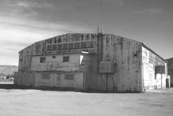 Figure 8.65. Manzanar auditorium in 1994. |
 Figure 8.66. Auditorium cornerstone. |
South of the auditorium was Block 7, used as the relocation center high school, but because the northern one-third of the block was within the fenced Inyo County Maintenance Yard, it has been very disturbed. The concrete slabs for the men's latrine, the women's latrine, the laundry room, and the ironing room have been removed; all that remains of them is a small pile of concrete rubble. Barracks remains consist of two concrete footing blocks, eight upright water faucet pipes, and a few evacuee-constructed rock alignments. Recently a septic system for the auditorium was put in Block 7 by the National Park Service.
Little remains at the elementary school, which made use of the buildings in Block 16, other than the concrete slabs of the toilets, laundry, and ironing room, some rock alignments, and a few other disturbed landscaping features.
At the Children's Village, the three building locations are marked by some of the original foundation blocks. Gully erosion has destroyed the original road to the north of the Children's Village; a replacement dirt road now crosses the building locations.
Remains of sports and recreation facilities can be found within the evacuee residential area. A basketball post is at Block 3. There are decorative rock alignments, concrete slabs, concrete stoops, and elaborate rock-lined cobble and concrete walkways at the location of the evacuee-built judo house south of Block 16 (Figure 8.67). Remains of baseball and softball fields in the firebreak between Blocks 19 and 25 include lumber fragments and downed chicken wire, mostly buried by drifting sand, where the backstops used to be, and a low earthen mound at the baseball field's pitcher's mound. There is a wood home plate in the firebreak between Blocks 30 and 35 (Figure 8.68).
The firebreak west of the auditorium includes evidence of three tennis courts. There is a simple rock alignment remaining at one, remnants of concrete and rock net supports and an area of discolored soil (possibly from a clay court) at another, and a partial concrete border at the third one. The concrete border, roughly the size of a standard tennis court, has been badly damaged by a recent ditch.
 Figure 8.69. Rock work at Merritt (Pleasure) Park. |
Two large barbecue grills (Figure 8.71), constructed of concrete and stone, are in the central portion of the northern perimeter in an area used by the evacuees as a park (North Park). One is inscribed with "Ray Kobote, August 1943." Another grill, of much less substantial construction, is located in the perimeter southwest of Block 4. It consists of a crude, low U-shaped grill-like feature made of cement and concrete blocks.
In the southwest corner of the central area, west of the lath house location, there are several depressions, concrete rubble, and a portion of concrete wall at the location of the first relocation center outdoor theater. No remains associated with the nearby golf course and developed picnic area on Bairs Creek were located. Two concentrations of concrete steps and other rubble along the edge of Bairs Creek appear to be from dismantled buildings in the administration area.
There are still remnants of the evacuee and staff victory gardens in the firebreaks and around the perimeter of the residential area. Sections of pipe and ditches (both earthen and concrete-lined), some including lumber, fencing, and culverts, remain from the irrigation systems (Figure 8.72). The irrigation system that diverted water from Bairs Creek to the staff victory garden is largely intact, though no longer in use. It includes a dam, a concrete pipeline, earthen ditches, and a settling basin. Inscribed within the concrete cap wall of the dam is the date "1942." Along the ditch there are a low U-shaped concrete water diversion structures, one has several inscriptions, including names, initials, four 1943 dates (Figure 8.73), and a fallacious 1940 date.
 Figure 8.74. Pear trees near the Manzanar Childern's Village. |
There are no remains apparent at the guayule lath house that was southwest of Block 6. But nearby there are several features likely associated with the lath house, including a large rectangular area enclosed by tamarisk and a barbed wire fence, two shallow rectangular depressions possibly from gardens, and an 11-foot-square concrete slab with the inscription "12.30.42." Nearby are concentrations of sanitary seal cans with punched bottoms which were probably used for seedlings.
Other features in the perimeter of the central area include a capped well, a fuel oil storage tank area, and numerous small artifact concentrations. Most of the latter were probably deposited as the relocation center was abandoned. Also present are three building foundations; although two are depicted on the WRA blueprints, their functions are unknown. One has the inscription "1944." They may have served as storage for the victory gardens or outlying farms.


 Top
Top
Last Modified: Fri, Sep 1 2000 07:08:48 pm PDT
http://www.cr.nps.gov/history/online_books/anthropology74/ce8i.htm
![]()