![]()

Cover Page
MENU
![]() Manzanar
Manzanar
|
| |
Confinement and Ethnicity: An Overview of World War II Japanese American Relocation Sites by J. Burton, M. Farrell, F. Lord, and R. Lord |

|
|
| |
Chapter 8 (continued)
Manzanar Relocation Center
Outlying Area
Farm Fields and Irrigation Ditches
The only relocation center farm fields currently in use are the northernmost fields along the west side of U.S. Highway 395. All of the other fields and ditches of the relocation center farms lie abandoned.
Outside of the cultivated fields the ditches that brought irrigation water to the north fields are in good condition and easy to follow (Figure 8.83). There are numerous inscriptions in the concrete of the ditches, including names, initials, dates, Japanese characters, expressions of love, and a geometric design (Figure 8.84). A dam on Shepherd Creek, measuring approximately 46 feet across, was built for the early twentieth century town of Manzanar. Evacuees raised the height of the dam by adding 18 inches of concrete wall, and inscribed two sets of initials on top.
 Figure 8.83. Concrete-lined irrigation ditch near Shepard Creek. |
 Figure 8.84. Inscription in the Manzanar North Fields irrigation ditch. |
North and northeast of the northernmost farm fields there are two wells located on opposite sides of U.S. Highway 395, that were connected by a 2,750-foot-long concrete pipeline, now partially destroyed. An upturned concrete support near one of the wells is inscribed with "finished by tom fujisaki & crew mar. 23, 1944" (Figure 8.85). Parts of two bridges over Shepherd Creek built by the evacuees to access the north fields are still in use.
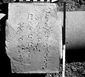 Figure 8.89. Japanese poem inscribed on pipeline support. |
At George Creek, 1 mile south of the central area just west of U.S. Highway 395, there is a dam, a bridge, two wells, concrete-lined ditches and concrete pipelines, and various water control features (Figure 8.92). Inscriptions in the irrigation ditches include dates and Japanese characters translated as family names. There is an upright boulder with two smaller cemented rocks as decorative elements at each corner of the 10-foot-by-16-foot bridge (Figure 8.93). Six inscriptions in the concrete of the retaining walls at the bridge and a nearby pipe support include names, dates, Japanese characters translated as "Built by E Group in March 1944," and two place names, both "tucson," one is dated "3/6/44."


 Top
Top
Last Modified: Fri, Sep 1 2000 07:08:48 pm PDT
http://www.cr.nps.gov/history/online_books/anthropology74/ce8l.htm
![]()