|
ROCKY MOUNTAIN
Circular of General Information 1936 |

|
AUTOMOBILE TRIPS
DENVER CIRCLE TRIP
The Trail Ridge Road, which crosses the Continental Divide in Rocky Mountain National Park, offers a grand circuit of Colorado's beauties that forms one of the most attractive and impressive of the scenic automobile trips of our country.
The trip starts from Denver, crosses the Continental Divide at Milner Pass in Rocky Mountain National Park, reaches Grand Lake, crosses the Continental Divide again at Berthoud Pass, traverses the Denver Mountain Parks, and returns to Denver, having completed without any duplication 240 miles of comfortable travel through magnificent country, full of interest and variety; the trip can be made in 2 days or it can be prolonged to suit individual time and inclination. It combines in one trip half a dozen features, any one of which by itself would be worth the journey. The Rocky Mountain Parks Transportation Co. operates daily scheduled trips over this route during the summer season.
On leaving Denver the road leads out Federal Boulevard, crosses Westminster Heights, from which point there is an extensive view of the Great Plains to the east and a panorama of the Front Range of the Rocky Mountains to the west, stretching out before the eye from Pikes Peak to Longs Peak, a rampart of mighty mountains, 125 miles from end to end. The road then passes through a farming section, where irrigation has turned what was once an arid plain into a richly productive district. Fields of deep green alfalfa alternate with the waving wheat, and in the fall of the year the harvesting and threshing add new life to the landscape. Next is the town of Lafayette, where coal mining is the principal industry, and then the road traverses a sugar-beet country. Colorado is the sugar bowl of the United States, and here is one of the regions where the beets are most successfully grown. At Longmont and Loveland are large factories, where sugar is extracted from the beets and refined for table use. At Loveland the road turns westward and soon plunges into the precipitous canyon of the Thompson River, where it follows the turns of the dashing stream, walled in by towering cliffs. Then comes the village of Estes Park at the edge of Rocky Mountain National Park and half surrounded by it. From the green of the meadowland the eye follows the slope, up, up, up, over timbered, hills and rocky cliffs, past timberline to the crest of the Continental Divide where snow lingers, and to Longs Peak.
Continuing the journey, two routes lie open to the motorist. One of these follows up the valley of Fall River, 2 miles beyond the Fall River gateway, and then turns left over a portion of the Highdrive to the beginning of the new Trail Ridge Road.
The other road leads past the Government museum and information office to Moraine Park and Deer Ridge, with a magnificent view of Longs Peak and the Continental Divide.
The Trail Ridge Road is one of the highest automobile roads in America. Its 4-mile section over 12,000 feet in altitude is probably the longest stretch of road ever built at such a height. The trip to Grand Lake on this road is a never-to-be-forgotten experience. The road climbs to the very crest of the range and then follows the ridge. Valleys and parks lie thousands of feet below, rivers look like tiny silver threads, and automobiles on the highways of the floor of the valley resemble minute moving dots.
To the south an unexcelled view of the most rugged portion of the Front Range is spread out, while to the north, across Fall River Valley, the view is dominated by the majestic Mummy Range, and the course of the Fall River Road may be traced as it zigzags up the slope of Mount Chapin toward Fall River Pass. Over a 350-foot cliff one may look into fascinating Iceberg Lake, a rock-bound crystal pool on which float blocks of ice.
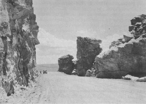
The Trail Ridge Road at an elevation of 12,120 feet. Clatworthy
photo.
A short distance beyond Iceberg Lake the highest point on the road is reached, 12,183 feet above sea level; the road descending to Fall River Pass, elevation 11,797 feet, which divides the waters of the Thompson River from those of the Cache la Poudre. The view from this point is unsurpassed. Below lie streams, valleys, forested slopes, and the realms of civilization. All around are mountains and peaks, no longer towering above but close at hand or seen across some mighty valley. One can easily trace the work done by the glaciers during the ice age on these mountain ranges; the broad U-shaped valleys and precipitous amphitheaters or cirques at the head of the streams are the typical glacial signs, written in bold letters on the landscape. To the south is Trail Ridge. Iceberg Lake, walled in by cliffs, is only a mile distant, though not in sight. To the west is Specimen Mountain, interesting because of the variety of color in its volcanic rocks, geodes lined with crystalline material, volcanic glass, and other curious formations. It is also the home of the mountain sheep.
Farther to the west lies the Medicine Bow Range, or, as the Indians so picturesquely named it, the "Never Summer" range. Of its many peaks the most prominent are Bowen, Nimbus, Red, Cumulus, Howard, Lead, and, highest of all in this range, Mount Richthofen, 12,953 feet in elevation. Strange as it may seem, Milner Pass lies below and one descends in order to cross the Continental Divide. The road drops down into the forest zone, passes Poudre Lakes, and crosses Milner Pass at an elevation of 10,759 feet. The Atlantic slope lies behind and, crossing the backbone of the continent, one travels down the Pacific slope to the headwaters of the Colorado River. The valley of the North Fork is hemmed in by mountains. The Continental Divide makes a loop here and blocks progress to the west, north, and east. The valley opens to the south, however, and the road proceeds down the north fork of the Colorado River.
Grand Lake, the sapphire gem on the western edge of the national park, is one of the largest and most beautifully situated lakes in the State. It is a mile and a half in length and nearly a mile in width. Its clear, cold water is of great depth. The lake lies at an elevation of 8,369 feet and claims the highest yacht club in the world. The annual regatta is an event of much interest. At the head of the lake Mount Craig rises to a height of 12,005 feet, while Shadow Mountain, Bryant, Wescott, and Mount Enentah are nearby.
This is a point of concentration for park visitors where nearly everybody spends at least 1 night. Fishing, boating, horseback riding, and mountain climbing are some of the outdoor attractions.
Leaving the lake, the road follows down the Colorado River, passes the town of Granby, and commences the climb up a beautifully timbered valley to Berthoud Pass. Here, close to timberline, the watershed between the two oceans is again crossed. The road approaches near Georgetown, famed for its railroad loop, and then passes through Idaho Springs, with its hot springs and medicinal baths. Soon the valley of Clear Creek is left behind and the climb to Bergen Park is made where the Denver Mountain Parks are entered. In this region is Lookout Mountain, where Colonel Cody, "Buffalo Bill", is buried, overlooking the plains he knew so well.
From Wildcat Point there is a splendid view of foothills and plains, with Denver some 12 or 14 miles away.
BEAR LAKE ROAD
The Bear Lake Road passes the Glacier Basin public camp ground, 7 miles from Estes Park, and then follows up the valley of Glacier Creek, passing near Sprague's Lodge, and ends at Bear Lake, 12 miles from Estes Park. This is one of the best roads within the park boundaries. Bear Lake Lodge, on the eastern shore of the lake, offers good accommodations. The trail to Loch Vale starts from the Bear Lake Road, about 10 miles from Estes Park. From this trail or from Bear Lake the hiker can reach some beautiful and scenic country, including Glacier Gorge, Loch Vale, Dream Lake, and Tyndall Gorge. The trail to Fern Lake and the Flattop Trail to Grand Lake may be conveniently reached from Bear Lake. North Longs Peak Trail also leaves the road at this point.
LOOP TRIP
One may combine portions of several roads by taking what is known as the "loop trip." Starting from Estes Park, the route follows the Fall River Road up to Chasm Falls and back to Horseshoe Park, then over Deer Ridge to Beaver and Moraine Parks, then a side trip up the Bear Lake Road and back returning to Estes Park by the Moraine Park Road. This loop trip takes one by many of the hotels and other points of interest and offers scenic views. The circuit of the Highdrive is 17 miles. Including the trip to Bear Lake and other points, the distance is about 40 miles.
LONGS PEAK AND WILD BASIN TRIP
The main road to the Longs Peak district comes in just east of the village of Estes Park, skirting the east boundary of the park to its southeast corner. It passes between Longs Peak and the Twin Sisters, a detached area of the park on which a fire lookout is stationed, and several of the finest foot trips in the park are accessible from this road.
Continuing in a southerly direction, the road skirts the eastern boundary of the park and leads to Copeland Lodge on North St. Vrain Creek. From this point a trail leads into Wild Basin, a very attractive though less frequented portion of the park.
The road continues to Allens Park, thence to Ward, Nederland, and Boulder; another road leads down the South St. Vrain to Lyons.
TRAIL TRIPS
Travelers on trails are advised to secure the services of licensed guides for all except the shortest trips. Besides insuring security, the guide adds greatly to one's comfort and enjoyment. He knows the country and its features of interest, and also has a general knowledge of the trees and wild flowers. Information as to guides can be secured at the park information office.
THE FLATTOP TRAIL
The Flattop Trail crosses the Continental Divide between Estes Park Village on the east and Grand Lake Village on the west. The 16-mile trip may be made on horseback or on foot in 1 day, but it takes a seasoned trail traveler to do it with pleasure. The trail starts at Bear Lake, where horses may be rented, and climbs Bierstadt Moraine. It emerges above timberline, overlooking Emerald Lake and Tyndall Glacier, and commands spectacular views of Longs Peak and other mountains, both in the park and in distant ranges. The grassy slopes above timberline, bedecked with exquisite alpine flowers, afford good summer grazing for elk and mountain sheep.
After descending to timberline on the western slope, the trail leads through evergreen forests, along the North Inlet to Grand Lake.
LAWN LAKE
The glories of the Mummy Range, exemplified chiefly in Lawn Lake and Rowe Glacier, may be seen from a trail starting from Horsehoe Park by way of Roaring River. There is a shelter on beautiful Lawn Lake. This lake, which has an area of 65 acres, lies at the bottom of the main cirque at the head of Roaring River. It is one of the many glacial lakes of the park, and lies just below timberline at an altitude of 10,950 feet.
The trip from Lawn Lake to Rowe Glacier is difficult but well worth while. The glacier is the largest in the park. It is a great crescent of ice partly surrounding a small lake. While the glacier is extremely impressive, still it is small enough to permit a thorough examination without undue fatigue. Hagues Peak is a resort of Rocky Mountain sheep and ptarmigan.
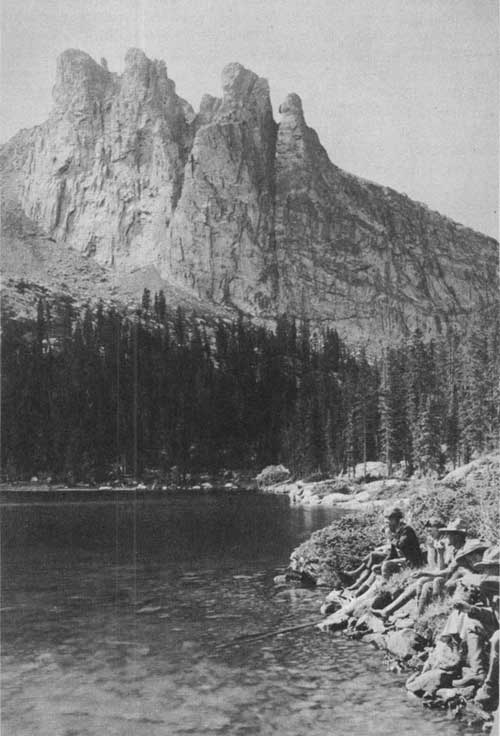
Hallet Peak, Tyndall Glacier, and Flattop Mountain, across Bear Lake.
FERN AND ODESSA LAKES
The group of luxuriant canyons east of the Continental Divide and north of the eastern spur which ends in Longs Peak is known as the "Wild Gardens" in distinction from the corresponding and scarcely less magnificent hollow south of Longs Peak, which is known as "Wild Basin."
Of these canyons, one, the most gorgeous, frames two lakes of exquisite beauty. The upper one, Odessa Lake, lies under the Continental Divide and reflects snowy monsters in its still waters. The other, Fern Lake, a mile below, is one of the loveliest examples of forest-bordered waters in the Rockies.
These lakes are reached by trail from Moraine Park. They constitute a day's trip of memorable charm. Fern Lodge, located at the edge of the lake, offers comfortable accommodations. Several splendid trips can be taken on foot with Fern Lake as a starting point. Winter sports are held here every year. Forest Inn, a camp located at the Pool, is close to the Fern Lake trail.
A trail connects Bear Lake with Odessa Lake. One of the finest trail trips in the park is the circle trip from Bear Lake to Odessa Lake, and thence to Fern Lake and Moraine Park. The distance from Bear Lake to the Brinwood by this route is 9 miles, but a day is usually allowed for the trip.
ROMANTIC LOCH VALE
Within a right-angled bend of the Continental Divide lies a glacier-watered, cliff-cradled valley which for sheer rocky wildness and the glory of its flowers has few equals. At its head Taylor Peak lifts itself precipitously 3,000 feet to a total height of more than 13,000 feet, and from its western foot rises Otis Peak, of nearly equal loftiness, the two carrying between them broken perpendicular walls carved by the ages into fantastic shapes. One dent encloses Andrews Glacier and lets its waters find the Loch. On the eastern side another giant, Thatchtop, sheltering the Taylor Glacier, walls in the upper end of Loch Vale. It is easily reached by a trail that leaves the Bear Lake Road, 10 miles from Estes Park, or 1 mile below Bear Lake.
In this wild embrace lies a valley 2 or 3 miles long ascending from the richest of forests to the barren glacier. Through it tinkles Icy Brook, stringing like jewels, three small lakes. Those who love to explore the undeveloped and less frequented regions will enjoy the wild beauty and impressive grandeur of Loch Vale. The Lake of Glass and Sky Pond, just below Taylor Glacier, can be visited in a day's trip. Another wonderful day can be spent in a trip to the foot of Andrews Glacier.
GLACIER GORGE
One of the noblest gorges in any mountain range the world over lies south of Loch Vale. It is reached from the Bear Lake Road, by the Loch Vale trail, although there are no trails in the gorge. Above Lake Mills the western wall of the gorge is formed by McHenrys Peak and Thatchtop; its head lies in the hollow between the Continental Divide and Longs Peak, with Chiefs Head and Pagoda looming on its horizon. Its eastern wall is the long sharp northern buttress of Longs Peak itself. It is a gorge of in describable wildness. Lake Mills lies near the mouth of the valley, Black Lake is toward the upper end, while Shelf Lake, Blue Lake, and several others are perched on benches high above the valley floor.
This gorge is magnificent and worth visiting. There is no trail to Keyhole, on the great shoulder of Longs Peak, but the ascent can be made. The canyon is luxuriantly covered in places with a large variety of wild flowers.
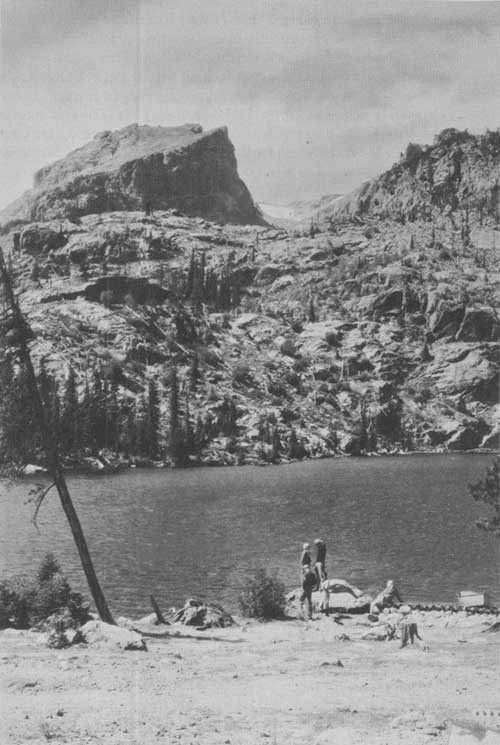
Lake Nanita. Denver Tourist Bureau photo.
THE TWIN SISTERS
Nine miles south of the village of Estes Park, split by the boundary line of the national park, rises the precipitous, picturesque, and very craggy mountain called the "Twin Sisters", on which the park maintains a fire lookout. Its elevation is 2,400 feet above the valley floor, which is about 9,000 feet high. The trail leads by many zigzags to a peak from which appears the finest view by far of Longs Peak and its guardians, Mount Meeker and Mount Lady Washington.
From the summit of the Twin Sisters an impressive view is also had of the foothills east of the park, with glimpses beyond of the great plains of eastern Colorado and many of their irrigating reservoirs.
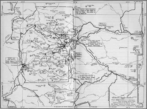 MAP OF ROCKY MOUNTAIN NATIONAL PARK. (Note Numbered blocks indicate the location of hotels, camps, and lodges listed at the end of this circular under "Private Hotels, Cottages, and Camps") (click on image for a PDF version) |
ASCENT OF LONGS PEAK
Of the many fascinating and delightful mountain climbs, the ascent of Longs Peak is the most inspiring, and it is one of the most strenuous. The great altitude of the mountain, 14,255 feet above sea level and more than 5,000 feet above the valley floor, and its position well east of the Continental Divide, affording a magnificent view back upon the range, make it much the most spectacular viewpoint in the park. The difficulty of the ascent also has its attractiveness. Longs Peak is the big climb of the Rocky Mountain National Park. And yet the ascent is by no means forbidding. One may go more than half-way by horseback. Over a thousand men and women, and occasionally children, climb the peak each season. Those making the Longs Peak trip should have strong, comfortable shoes, stout, warm clothing, and remember that cold or stormy weather is sometimes encountered.
The peak may be reached by either of two trails which lead to the Boulder Field, the highest point on the climb to which horses may be taken.
The east trail, which begins near Longs Peak post office, 9 miles south of Estes Park, winds up the slope of Battle Mountain, passes timberline at an elevation of more than 11,000 feet, swings to the crest of Mills Moraine, overlooking Chasm Gorge, then skirts the slope of Mount Lady Washington, goes through Granite Pass, and leads to the shelter cabin in the center of the Boulder Field, at an elevation of 12,700 feet, a distance of 6 miles.
From Glacier Gorge Junction on the Bear Lake Road, the north trail winds its way up the north slope of the peak through the great burn of 1900 and joins the east trail at Granite Pass, a mile and a half below the Boulder Field cabin. The distance to the Boulder Field by this trail is 9 miles.
From the Boulder Field Cabin the ascent to the summit may be made by either of two routes. The north face route, which is the shorter, climbs the precipitous north side of the summit, skirting along the rim of the east precipice, with magnificent views down the sheer drop of 1,200 feet into Chasm Lake in the gorge below. The other route leads across the Boulder Field to the Keyhole, half a mile distant and some 500 feet higher, where there is a small storm shelter.
On passing through the Keyhole, one sees the imposing Front Range, and 2,000 feet below the Glacier Gorge. To the left there is a narrow, steeply inclined ice-filled gulch, called the Trough. Finally, after what is to the amateur often an exhausting climb, one passes along the Narrows, up a steep incline known as the Homestretch.
The trip to the Keyhole is well worth while for those who do not care to climb Longs Peak, but who do wish to see at close range the rugged grandeur of the mountains. Another splendid foot trip from the Boulder Field cabin is to Chasm View, half a mile distant, where one sees the precipitous east face of Longs Peak, from the summit down to Chasm Lake, 2,500 feet below.
CHASM LAKE
One may ride on horseback almost to Chasm Lake. The view from here is magnificent, and the upper gorge is one of the most impressive in the park. Both Chasm Lake and the Keyhole may be visited in a day. This is an exceptionally fine trip, and if horses are used it is not difficult.
WILD BASIN
The splendid Wild Basin area south of Longs Peak and east of the Continental Divide is dotted with lakes of superb beauty in a sublime mountain setting. It is entered from Copeland Lake by an unimproved road up the North Fork of St. Vrain Creek, which soon lapses into a rude trail. From mountain tops on the south may be had unsurpassed views of the snowy mountains. The largest lakes of Wild Basin—Thunder Lake and Bluebird Lake—are both above timberline but are easily accessible by trails.
GRAND LAKE
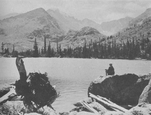
The North and East Inlets are the two principal rivers entering beautiful Grand Lake. Each flows from cirques under the Continental Divide. Lake Nokoni and Lake Nanita, among the most romantic of the park, are reached from a trail connecting with both sides of the park by the Flattop Trail. Lake Verna and her unnamed sisters are the beautiful sources of the East Inlet and are reached by trail.
While not yet as celebrated as the showier and more populated east side, the west side of Rocky Mountain National Park has rugged charm. The Continental Divide, bent from the north and called the "Never Summer Mountains", rises from the western shore of the Colorado River. On every side the mountains lift bald peaks, magnificent canyons penetrate the precipices of the Divide, and beautiful streams rush down the mountain slopes to the river.
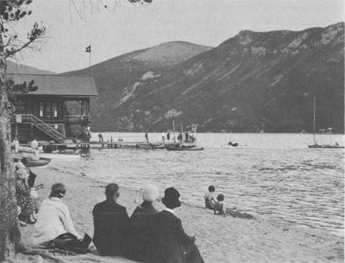
Enjoying water sports at Grand Lake. Grant photo.
WHAT TO DO
There are few places which offer so many diversions as Rocky Mountain National Park. The Estes Park Golf and Country Club has an excellent 18-hole golf course and a tennis court. Several hotels have croquet and tennis courts. There is much motoring, horseback riding, fishing, and hiking. The motorist may skirt the loftiest of snow-splashed mountains for miles, or he may motor up the Trail Ridge Road and leave his car to start afoot on mountain-top tramps and picnics, or across the Continental Divide to Grand Lake. The horseback rider may find an infinite variety of valley roads, trails, and cross-country courses, and the hiker strike up the mountain trails into the rocky fastnesses.
FISHING
Fishing is permitted in all streams and lakes of the park except as closed by order of the superintendent. Information regarding closed areas may be obtained at any ranger station. All of the lower streams and lakes, and many of the lakes in the higher altitudes, are well stocked with trout. The State of Colorado stocks the park waters, and, therefore, a Colorado State license is required for males over 16 years of age. These may be purchased in the villages of Grand Lake and Estes Park. Fishing tackle can be purchased or rented from several stores in the village of Estes Park.
A fish hatchery, operated by the State of Colorado, is located on the Fall River Road, 4 miles west of Estes Park. This hatchery supplies about 1,000,000 trout fry every year to the streams and lakes of this vicinity. The process of hatching and caring for the trout is explained to visitors, and the hatchery has proved to be of interest to many thousands each year.
Bear Lake offers fine fishing. Grant photo.
HORSEBACK RIDING AND CAMPING
At Estes Park and the smaller settlements nearby, and at Grand Lake, horses and complete camping outfits may be had at reasonable rates. General groceries and suitable equipment, including clothing and shoes, can be purchased from the general stores in Estes Park Village Saddle horses may be rented at many of the hotels. There is much horseback riding throughout the entire district.
There are many competent guides in the vicinity who will arrange special trips, either on foot or by saddle horse, and either stopping at hotels or camping out, according to the preference of the party. A list of authorized guides can be secured at the park information office.
WINTER SPORTS
Rocky Mountain National Park has unusual advantages for winter sports, interest in which is steadily increasing. The town of Estes Park is readily accessible by automobile, and hotel accommodations are available there every month in the year. The Rocky Mountain National Park Ski Club has constructed ski courses near Estes Park where tournaments are held periodically. Cross-country trips may be taken in the high mountainous country where the snowfall is heavy and where good skiing conditions prevail during the winter and early spring. Allens Park and Grand Lake also have ski clubs and ski courses. Skijoring, snowshoeing, tobogganing, and skating may also be enjoyed.
Midsummer ski carnival.
PUBLIC CAMP GROUNDS
The National Park Service maintains six free public camp grounds, as follows:
Squeaky Bob Camp Ground, located on the Fall River Road, 38 miles west of Estes Park, and 12 miles north of Grand Lake.
Glacier Basin Camp Ground, located on the Bear Lake Road, 7 miles from Estes Park.
Aspenglen Camp Ground, located on the Fall River Road, 5 miles from Estes Park.
Wild Basin Camp Ground, 15 miles south of Estes Park on the North St. Vrain Creek at the park boundary.
Endovalley Camp Ground, located on the Fall River Road, 9 miles from Estes Park.
Longs Peak Camp Ground, located at the beginning of the east Longs Peak Trail near Longs Peak post office.
Motorists and others who bring camping equipment with them will find that these camp grounds are attractive places in which to enjoy life in the open. Both wood and water are readily available.
NATURALIST SERVICE
Illustrated lectures are given at various points throughout the park and vicinity each evening. Nature hikes, from a few hours to a day in length, are conducted regularly.
A museum of natural history containing interesting exhibits is located near the office. An information office is maintained in the same building, which dispenses road and general information. A small branch museum is located at Fall River Pass. A museum of Indian and historical material is located on the main highway in Moraine Park.
A complete schedule of the week's activities is posted at all hotels, lodges, and camp grounds. For detailed information inquire at the museum. There is no charge for any of the above-mentioned activities.
| <<< Previous | <<< Contents>>> | Next >>> |
1936/romo/sec3.htm
Last Updated: 20-Jun-2010