|
MOUNT RAINIER
Guidebook 1941 |

|
| OPEN ALL YEAR |
 |
MOUNT RAINIER NATIONAL PARK WASHINGTON |
||
|
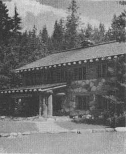
ADMINISTRATION BUILDING AT LONGMIRE
| ||||
MOUNT RAINIER NATIONAL PARK was established by act of Congress, approved by President McKinley, March 2, 1899. A subsequent act, January 31, 1931, extended the east boundary to the summit of the Cascade Range, the boundary recommended by the original bill. The park embraces 377.78 square miles (241,782 acres).
"THE MOUNTAIN"
Mount Rainier, sometimes called "the mountain that was God," rises 14,408 feet and is the fourth highest mountain in the United States. It is approximately 11,000 feet above its immediate base and Covers 100 square miles, one-fourth of the area of the park.
Unlike cone-shaped Fujiyama, Mount Rainier is a broadly truncated mass resembling an enormous tree-stump with spreading base and irregularly broken top. Its crowning snow mound bears the proud name of Columbia Crest.
Like all volcanoes, Mount Rainier's cone was built by its own eruptions—with cinders and steam-shredded particles, lumps of lava, and occasional flows of liquid lava that have solidified into layers of hard andesite rock. Judging by the steep inclination of the lava and cinder layers visible in its flanks, it is thought to have once attained an altitude of 16,000 feet. In subsequent explosions, the top 2,000 feet was destroyed, leaving a vast 3-mile crater surrounded by a jagged rim. Within this, small cinder cones were built up, forming the dome now constituting the main peak, and rising 300 feet above the old crater rim. Prominent among these are Point Success (14,150 feet) and Liberty Cap (14,112 feet).
Mount Rainier has more glaciers than any other peak in the United Stares proper. Five, the Nisqually, Ingraham, Emmons, Winthrop, and Tahoma, originate at the top, while others, born of snows in immense cirques, merge impressively into the glistening armor of the great volcano. Most notable are the Cowlitz, Fryingpan, Carbon, Russell, North and South Mowich, and Puyallup. Mount Rainier's glacial mantle totals more than 40 square miles.
FLOWERS AND FORESTS
In glowing contrast to the glaciers are the multicolored wild flowers. Almost 700 species of flowering plants, in addition to hundreds of ferns, mosses, and fungi, are found in Mount Rainier National Park. The most noted of the highly spectacular flower fields of the alpine meadows are Indian Henrys Hunting Ground, Paradise Valley, Van Trump Park, Summerland, Spray Park, Berkeley Park, and Klapatche Park.
Dense evergreen forests characterize the lower slopes along the main rivers of the park. Up to the 3,000-foot elevation are seen the western hemlock, Douglas fir, western red cedar, amabilis and grand fir, and western yew. Between 3,000 and 4,500 feet are the amabilis and noble fir, western hemlock, Alaska cedar, and western white pine. The alpine fir and mountain hemlock are dominant at the 5,000-foot elevation, but white-barked pine and Engelmann spruce are also found. As elevation increases size diminishes, the extreme limit of tree growth being 7,500 feet.
MOUNT RAINIER SUMMIT CLIMB
To insure safety, all prospective summit climbers must register with a District Park Ranger at the time of starting a climb and upon returning from the ascent. Climbers must give evidence that they are physically capable, have had experience in similar hazardous climbing, and have proper equipment. Mount Rainier is not an easy climb, being dangerously crevassed and having ridges of treacherous crumbling lava and pumice. Independent parties may climb provided there are qualified and experienced leaders. Professional guides and proper equipment may be obtained at Paradise Valley (5,557 feet) from July 1 to Labor Day (approximate dates) for climbs via Kautz and Muir routes to the summit. Emmons route starts at White River Campground (4,500 feet) on the north side of the mountain.
WINTER SPORTS
During winter months, 600 inches of snow falls on mile-high Paradise Valley, on the south side of Mount Rainier, to cover the alpine area 20 feet deep and provide superlative ski runs of as long as 5 miles over expansive, unobstructed terrain. The ski season opens with December, when approximately 3 feet of snow is on the ground, under normal weather conditions. Winter skiing continues through January, February, and early March.
In March, April, and early May, warm sunshine favors Paradise Valley to bring skiing to its best. Light Clothing is worn, and skiers gain a deep sun tan while following the exhilarating sport.
During the ski seasons, there normally is a wide choice of hotel services at Paradise Valley on week ends and holidays (but no accommodations midweek) and continuous service for a part of the spring ski season. When accommodations are not available at Paradise Valley, facilities are offered at Longmire. However, before planning a winter stay either at Paradise Valley or Longmire, it is advisable to write Rainier National Park Co., Tacoma, Wash.
At Paradise Valley a ski tow, 1,350 feet long, takes skiers to a starting point for downhill runs as long as 2 miles, and a ski school with competent instructors is operated.
FISHING
No license is needed to fish in the park.
Relatively good fishing may be enjoyed in park lakes and streams which are stocked each year with various species of trout. Lakes are open to fishermen from July 1 to September 30, inclusive, and streams from June 1 to October 15, inclusive, unless posted closed. Fishing tackle and bait may be purchased, and boats may be rented at Reflection Lake near Paradise Valley.
ROADS AND TRAILS
Outstanding points of interest may be reached along park roads, but the most spectacular scenery and fascinating natural phenomena are reached by trails.
Wonderland Trail, a 95-mile circuit of the peak, affords great pleasure to those who wish to enter remote areas. Overnight shelters are provided along the trail.
Tables indicating distances by road and by trail to these scenic attractions are given at the end of this booklet.
GUIDE SERVICES
Rainier National Park Co. guide department at Paradise Valley rents complete hiking and climbing equipment. Professional guides lead daily parties onto Nisqually Glacier, to Paradise Glacier for "Tin Pants" sliding, and to other places of interest. Summit trips are guided as desired. Special fishing parties are conducted from Paradise Valley to Reflection Lake, with hiking equipment, fishing tackle, and a boat included. Prices are reasonable.
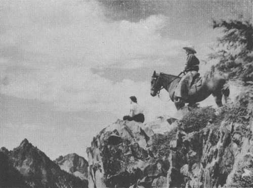
Daily saddle trips are conducted by horse "wranglers" (guides) from Paradise Valley and Yakima Park. Special guide services and saddle horses are available for trips to all sections of the park.
ADMINISTRATION
Mount Rainier National Park is administered by the National Park Service, with the superintendent in immediate charge. Park headquarters are at Longmire.
NATURALIST SERVICES
Lectures.—During the summer, talks on the natural history of this park, illustrated with motion pictures and colored slides, are offered nightly at Paradise Valley; nightly, except Sunday, at Yakima Park and Longmire; and occasionally at Ohanapecosh. Programs start at 8 p. m.
Museums.—Museums are maintained at Longmire and Ohanapecosh; natural history displays at Paradise Valley and Yakima Park.
Hikes.—In summer, free hikes are conducted by ranger naturalists daily from public centers to nearby features. From Longmire—half or full day trips; from Paradise Valley—two hour trips twice daily; from Yakima Park and Ohanapecosh—trips of varying distances. Trips are announced at lectures and posted on bulletin boards at museums and natural history displays.
Nature Trails.—"Trail of the Shadows" at Longmire; "Snout of Nisqually Glacier," reached from Glacier Bridge on Nisqually Road between Longmire and Paradise Valley; "Nisqually Vista Trail" at Paradise Valley; and "Emmons Vista" at Yakima Park. Along these trails, trees, flowers, and points of interest are labeled for ready identification.
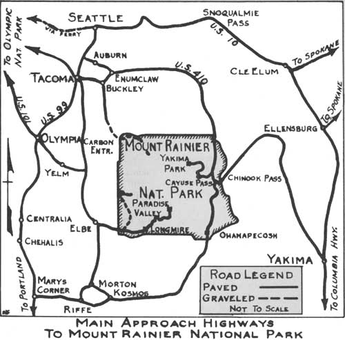
MAIN APPROACH HIGHWAY TO MOUNT RAINIER NATIONAL PARK
FREE PUBLIC CAMPGROUNDS
Comfortable campgrounds at Longmire, Paradise Valley, Yakima Park, and Ohanapecosh are equipped with stoves, wood, tables, water, and sanitary facilities. Campgrounds at White River, Tahoma Creek, and Carbon River, although less developed, have similar facilities. At Tahoma Creek water must be taken from a stream. Food supplies may be purchased at Longmire, Paradise Valley, Yakima Park, and Ohanapecosh.
SEASONS
Activities within the park are at their height in summer and winter months; however, many visitors find conditions during the spring and fall enjoyable. The height of the summer season is from about June 25 to early September. All roads are open by late June if unusually heavy winter snowfall does not delay the opening of the season; trails in lower elevations are open by late June, upper trails by late July. During this period all hotels and cabins are operating, campgrounds in lower areas are open, with the high elevation camp grounds usually available by mid-July. It is advisable to write the Superintendent, Mount Rainier National Park, Longmire, Wash., for exact dates of road openings each spring.
Formal introduction of the winter sports season usually is about mid-December, and it continues well into May. The most exhilarating ski season is from mid-March to early May when warm spring sunshine floods the snow. During May and early June, skiing is still relatively good. Often there is sufficient snow for skiing at Paradise Valley as early as Thanksgiving.
During late September and October leaves of bushes and ground cover in alpine meadows are brightly colored with reds and yellows. Crisp weather invites hiking trips.
Nisqually Road to Longmire and Paradise Valley sections of the park on the south side of Mount Rainier is maintained throughout the year; accommodations always are available at one or both centers.
APPROACH HIGHWAYS TO PARK
Mount Rainier National Park, situated in the west central section of Washington, is easily accessible by fine highways from Tacoma, Seattle, and Yakima, Wash., and Portland, Oreg. The East Side park road affords a through route inside the park so motorists may loop from Tacoma or Seattle through the north and east park sections and continue south to Portland.
MOTOR COACH SERVICE TO PARK
Rainier National Park Co. operates motor coaches from Tacoma and Seattle to Longmire and Paradise Valley throughout the year. During winter months motor coaches above Narada Falls (4 miles below Paradise Valley by road and 1.1 miles by trail) operate only on weekends. Roundtrip fare from Tacoma to Paradise Valley is $9; from Seattle, $10.50. During the summer months motor coaches are run from Tacoma, Seattle, and Yakima to Yakima Park (Sunrise). Roundtrip fare from any of the three cities to Yakima Park is $10.50. "Between station" motor coach service is available within the park and automobiles may be rented for trips from hotels.
TABLE OF MILEAGES
Paradise Valley-Yakima Park, via Ohanapecosh, 131 mi.
Paradise Valley-Yakima Park, via Tacoma, 152 mi.
Paradise Valley-City of Yakima, via Ohanapecosh and Yakima Park, 229 mi.
Yakima Park-Portland, via Ohanapecosh and Paradise Valley, 297 mi.
Yakima Park-Tacoma, via Ohanapecosh and Paradise Valley, 205 mi.
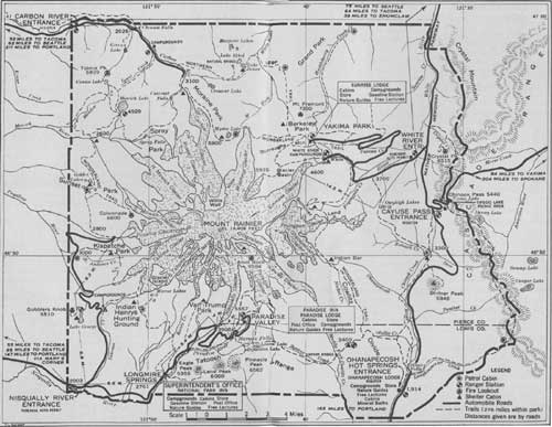 GUIDE MAP SHOWING ROADS AND TRAILS IN MOUNT RAINIER NATIONAL PARK, 1941 (click on image for a PDF version) |
RAILROAD, BUS, AND AIRPLANE SERVICES
The three gateway cities to the park—Seattle, Tacoma, and Yakima—are reached by a number of railway, bus, and airlines. Information on these services may be secured from travel agencies.
HOTEL AND CABIN FACILITIES
This booklet is issued once a year and rates mentioned herein may have changed slightly since issuance. Latest rates may be obtained by writing The Superintendent, Mount Rainier National Park, Longmire, Wash.; Rainier National Park Co., Tacoma, Wash., for rates at Paradise Valley, Yakima Park, and Longmire; Ohanapecosh Hot Springs Lodge, Packwood, Wash., for rates at Ohanapecosh.
At Paradise Valley.— Fine accommodations are offered in Paradise Inn, American plan, from $6.50 each for two persons in a room, without bath, to $9 for a single room, with bath. Room rates at Paradise Lodge, European plan, are from $2.25 each for two persons in a room, without bath, to $4 for a single room, with bath. A restaurant operates at Paradise Lodge. Housekeeping cabins, equipped with cook stove, wood, cold running water, and lights are available, furnished, except bedding, linen, and dishes, at $1.75 for two persons; with bedding and linen, but no dishes, at $2.50 for two persons. Three-room cabins for four persons are available at rates double those for two persons.
A grocery store and fountain also operate at the lodge.
At Yakima Park.— Housekeeping cabins are available at Sunrise Lodge at the same rates as at Paradise Valley. A cafeteria, grocery store, and fountain also operate at the lodge.
At Longmire.— Rates range from $1.50 each for two in a cottage room to $3.50 for a single room, with bath, in National Park Inn. Cabins are available at same rates as at Paradise Valley. A lunch counter, fountain, and grocery store also, operate at Longmire.
At Ohanapecosh.— Accommodations may be obtained at Ohanapecosh Lodge at $4 a day, including meals, and $19 a week. Housekeeping cabins are operated at prices, varying according to the number in party, from $1.25 a day to $15 a week. A store is operated throughout the summer season.
Modern bathing facilities are available at Ohanapecosh under supervision of a trained attendant for those desiring to use the hot mineral waters.
POST OFFICE—TELEPHONE—TELEGRAPH
Post offices are maintained at Longmire, Wash., all year and at Paradise Inn, Wash., and Sunrise Lodge, Wash., (at Yakima Park) from July 1 to Labor Day. Telephone communication to all sections of the park and long distance telephone and telegraph services from the park are available.
TABLES OF DISTANCES
The following tables of distances are presented to assist park visitors in planning trips within the park both by roads and by trails. Points of interest along roads as well as principal features to be reached by short trails from recreation centers are listed. Elevation figures and brief remarks tell some thing of the features.
NISQUALLY ROAD, NISQUALLY ENTRANCE TO PARADISE VALLEY—20 MILES.
| Name | Distance from | Elevation above sea level |
Remarks | |
| Park entrance |
Paradise Valley | |||
| Miles | Miles | Feet | ||
| West Side Road Junction | 1.0 | 19.0 | 2,100 | West Side Road is open 15.1 miles to North Puyallup River. |
| Tahoma Creek | 1.2 | 18.8 | 2,120 | 60-foot cedar-log bridge over stream. |
| Columbus Tree | 3.4 | 16.6 | 2,363 | Large Douglas fir over 700 years old. |
| Kautz Creek | 3.6 | 16.4 | 2,378 | Glacial stream. |
| Bear Prairie Point | 4.8 | 15.2 | 2,500 | Magnificent view of mountain. |
| Longmire | 6.6 | 13.4 | 2,761 | Superintendent's headquarters, campgrounds, National Park Inn and cabins, store, park museum, post office, community building. |
| Indian Henrys Trail | 7.0 | 13.0 | 2,850 | Trail to Indian Henrys Hunting Ground, 6.5 miles. |
| Christine Falls | 10.9 | 9.1 | 3,667 | Beautiful falls. Trail to Comet Falls and Van Trump Park, 3 miles. |
| Glacier Bridge | 11.9 | 8.1 | 3,908 | Trail to "snout" of Nisqually Glacier, 1/2 mile. |
| Ricksecker Point | 13.4 | 6.6 | 4,212 | Fine view of mountain and surrounding country. |
| Silver Forest | 15.0 | 5.0 | Fire-killed, weathered gray tree trunks. | |
| Narada Falls | 16.0 | 4.0 | 4,572 | Falls in Paradise River; 168-foot drop. |
| Paradise Valley | 20.0 | 0.0 | 5,557 | Ranger station, campground, Paradise Inn, Paradise Lodge and cabins, store, community building, post office. |
WEST SIDE ROAD, NISQUALLY ROAD TO NORTH PUYALLUP RIVER—15.1 MILES
| Name | Distance from | Elevation above sea level |
Remarks | |
| Nisqually Road |
North Puyallup River | |||
| Miles | Miles | Feet | ||
| Fish Creek | 3.9 | 11.2 | 2,923 | Small clear stream; fishing. |
| Tahoma Campground | 4.2 | 10.9 | 3,146 | Wonderland Trail branches to Indian Henrys Hunting Ground, 4 miles. |
| Tahoma Vista | 5.4 | 9.7 | 3,458 | Fine view of mountain and surrounding country. |
| Round Pass | 6.9 | 8.2 | 3,879 | Trail to Lake George, 1.2 miles (fishing) and Gobblers Knob Fire Lookout, 3 miles. Vista of mountain. |
| South Puyallup River | 8.3 | 6.8 | 3,479 | River crossing. |
| St. Andrews Creek | 11.2 | 3.9 | 3,743 | Trail to Klapatche Park, an alpine meadow, 3 miles. |
| Klapatche Point | 12.4 | 2.7 | 4,117 | Fine viewpoint. |
| North Puyallup River | 15.1 | 2.7 | 3,707 | Parking area. View of Hanging Glacier. Trail to Klapatche Park, 3 miles; Sunset Park, 4.5 miles. |
WHITE RIVER ROAD, U. S. HIGHWAY 410 (NACHES HIGHWAY) TO YAKIMA PARK—15.6 MILES.
| Name | Distance from | Elevation above sea level |
Remarks | |
| U.S. Highway 410 |
Yakima Park | |||
| Miles | Miles | Feet | ||
| Entrance checking station | 1.4 | 14.2 | 3,470 | Ranger station. Purchase automobile permit. |
| East Side Trail | 3.8 | 11.8 | 3,745 | Trail to Owyhigh Lakes and Ohanapecosh. |
| Fryingpan Creek Bridge | 4.4 | 11.2 | 3,840 | Wonderland Trail to Summerland and Paradise Valley. |
| White River Bridge | 5.4 | 10.2 | 3,965 | Road to White River Campground. Trail to "snout" of Emmons Glacier, Glacier Basin, Yakima Park. |
| Yakima Creek | 8.2 | 7.4 | 4,830 | Drinking water. |
| Sunrise Point | 12.9 | 2.7 | 5,085 | Panorama of surrounding peaks. |
| Yakima Park | 15.6 | 0.0 | 6,400 | Ranger station, campgrounds, Sunrise Lodge and cabins, store, post office. |
EAST SIDE ROAD, OHANAPECOSH ENTRANCE TO CAYUSE PASS ON U. S. 410—12.7 MILES.
| Name | Distance from | Elevation above sea level |
Remarks | |
| Ohanapecosh Entrance |
Cayuse Pass | |||
| Miles | Miles | Feet | ||
| Campground | 0.1 | 12.6 | 1,914 | Public campground beside Ohanapecosh River. |
| Ohanapecosh Hot Springs | 0.4 | 12.3 | 1,983 | Lodge, cabins, store, mineral baths. |
| Laughingwater Creek Trail | 1.6 | 11.1 | 2,120 | Spur to Cascade Crest Trail. |
| Silver Falls Trail | 1.6 | 11.1 | 2,120 | Beautiful falls on Ohanapecosh River. |
| Cedar Flat | 3.0 | 9.7 | 2,193 | Stand of large, virgin cedar trees. |
| Panther Creek | 4.1 | 8.6 | 2,310 | Clear mountain stream. |
| Shriner Peak Trail | 5.3 | 7.4 | 2,473 | Trail to fire lookout station. |
| Vista of Mountain | 5.5 | 7.2 | 2,650 | Mount Rainier above ridges. |
| Road Tunnel | 10.1 | 2.6 | 3,905 | Tunnel 512 feet long. |
ROAD DISTANCES BETWEEN YAKIMA PARK (SUNRISE) AND OHANAPECOSH
(Via continuous route over White River Road, section of U. S. Highway 410
(Naches Highway) and East Side Road—31.8 miles)
| Name | Distance from | |||||
| Yakima Park (Sunrise) |
White River Entrance |
Junction W. R. Rd. & U. S. Highway 410 |
Cayuse Pass |
Tipsoo Lake East of Cayuse Pass |
Ohanapecosh Entrance | |
| Yakima Park (Sunrise) | ---- | 14.2 | 15.6 | 19.1 | 22.1 | 31.8 |
| White River Entrance | 14.2 | ---- | 1.4 | 4.9 | 7.9 | 17.6 |
| Junction White River Road & U. S. Hwy. 410 (Naches Highway) | 15.6 | 1.4 | ---- | 3.5 | 6.5 | 16.2 |
| Cayuse Pass (Junction U. S. 410 and East Side Road) | 19.1 | 4.9 | 3.5 | ---- | 3.0 | 12.7 |
| Tipsoo Lake (East of Cayuse Pass) | 22.1 | 7.9 | 6.5 | 3.0 | ---- | 15.7 |
| Ohanapecosh Entrance | 31.8 | 17.6 | 16.2 | 12.7 | 15.7 | ---- |
PRINCIPAL POINTS OF INTEREST
REACHED FROM PARADISE VALLEY
(Best reached on foot)
| Name | Distance and direction from Paradise Valley |
Elevation above sea level | Remarks |
| Miles | Feet | ||
| Nisqually Glacier | 1.2 W | 5,500 | Largest glacier on south side of Mount Rainier. |
| Glacier Vista | 1.2 N | 6,300 | Wonderful view of entire Nisqually Glacier and mountain. |
| Panorama Point | 1.8 N | 6,800 | Panorama of Paradise Valley and Nisqually watershed. |
| Alta Vista | .6 N | 5,800 | Fine view; marker to identify all peaks and prominent points. |
| Stevens Monument | 1.5 NE | 5,900 | Where Chief Sluiskin, Indian guide, waited return of first summit climbers. |
| Golden Gate | 1.5 NE | 6,500 | Where Paradise Glacier and Skyline Trails cross. |
| Reflection Lakes | 1.5 SE | 4,861 | Beautiful lakes below Tatoosh Range; fishing. |
| Pinnacle Peak | 3.0 SE | 6,562 | Sharp peak on Tatoosh Range. Interesting trip from Paradise Valley. |
| Unicorn Peak1 | 4.7 SE | 6,939 | Highest peak on Tatoosh Range. |
| Sluiskin Falls | 1.2 NE | 5,900 | First fall of Paradise River below Paradise Glacier, 300 feet high. |
| Paradise Glacier | 1.5 NE | 6,500 | Clear ice glacier. Source of Paradise River. |
| Stevens Glacier1 | 1.7 NE | 6,000 | Glacier draining into Stevens Canyon. |
| Stevens Canyon | 2.2 NE | Below Stevens Glacier, 4 miles long, 1/2 mile wide, 1,000 to 2,000 feet deep. | |
| Mazama Ridge | 1.0 SE | 5,900 | Noted for abundance of wild flowers. |
| Faraway Rock | 2.5 SE | 5,300 | Excellent panorama of Tatoosh Range with lakes in foreground. |
| Lake Louise | 2.5 SE | 4,500 | Beautiful lake. Fishing. |
| Cowlitz Glacier1 | 3.0 NE | 4,500 | Largest glacier on southeast side of the mountain. |
| Cathedral Rocks1 | 3.2 N | 8,262 | Lofty spires between glaciers. |
| McClure Rock | 3.1 N | 7,384 | Flat rocky platform overlooking Paradise Glacier. |
| Anvil Rock Fire Lookout station1 | 3.5 N | 9,584 | Sharp crest halfway between McClure Rock and Camp Muir. |
| Camp Muir Shelter1 | 4.0 N | 10,000 | Overnight shelter for summit climbers. To this point the ascent is relatively easy. |
| Beehive2 | 5.0 N | 11,033 | Pinnacle on Cowlitz Cleaver. Its shape resembles a beehive. |
| Camp Misery2 | 5.5 N | 11,900 | Above the Beehive. |
| Gibraltar Rock2 | 6.0 N | 12,679 | Large rock mass at head of Cowlitz Glacier; a prominent feature of mountain seen from south sections of park. |
| Register Rock2 | 7.8 N | 14,161 | First point reached on rim of east crater. |
| Columbia Crest2 | 8.3 N | 14,408 | Highest point on Mount Rainier. |
| Point Success2 | 8.5 N | 14,150 | Most southern summit. About 250 feet lower than Columbia Crest. |
| Liberty Cap2 | 8.8 N | 14,112 | High point near the north end of mountain. |
1Upper section of trail is merely a route over snow. 2Climbing permits must be obtained from District Ranger to make ascent. | |||
 TRAILS LEAD HIKERS AND SADDLE PARTIES TO VISTAS OF NATURAL BEAUTY |
REACHED FROM LONGMIRE
(Best reached on foot)
| Name | Distance and direction from Longmire |
Elevation above sea level | Remarks |
| Miles | Feet | ||
| Trail of Shadows | 0.5 N | 2,761 | A loop trail through deep woods; mineral springs; homestead cabin. Trees, flowers, and other features labeled. |
| Ramparts Ridge | 2.0 N | 4,080 | Good view of Mount Rainier and Kautz Creek Valley. |
| Eagle Peak | 3.5 E | 5,955 | West end of Tatoosh Range. Magnificent view of mountain and surrounding country. |
| River Trail | 1.2 NE | 3,100 | Easy trail through fine forest. Cross Nisqually River on log and return via opposite side of river for loop. |
| Public campgrounds | 0.5 E | 2,700 | Free auto camp, community house, where talks are given by a naturalist. |
| Beaver dams | 2.3 S | 2,500 | Interesting beaver workings. |
| Narada Falls | 4.4 NE | 4,572 | Principal falls in Paradise River with sheer drop of 168 feet. |
| Paradise Valley | 5.5 NE | 5,557 | Camps, hotels; base for mountain climb. |
| Van Trump Park3 | 2.7 N | 5,500 | Beautiful alpine meadow. Mountain goats often seen here. |
| Indian Henrys Hunting Ground4 | 4.0 N | 5,500 | Alpine meadow on west side of mountain; luxuriant wild flowers; Mirror Lake. |
| Lake George5 | 1.5 NW | 4,232 | Beautiful mountain lake; fishing. |
| Gobblers Knob5 | 3.3 NW | 5,540 | Impressive vista of mountain, southwest section of park and surrounding area. |
3Distance is from Christine Falls on Nisqually Road. 4Distance is from Tahoma Campground on West Side Road. 5Distance is from Round Pass on West Side Road. | |||
REACHED FROM YAKIMA PARK
(Beat reached on foot)
| Name | Distance and direction from Yakima Park |
Elevation above sea level | Remarks |
| Miles | Feet | ||
| Sourdough Trail | 2.5 N | 6,500 | Easily accessible trail to Frozen Lake and Dege Peak. Wonderful view of Mount Rainier. |
| Burroughs Mountain | 2.5 W | 7,000 | Panorama of Mount Rainier and surrounding ranges. |
| Frozen Lake | 1.3 NW | 6,700 | Water-supply reservoir. Barren region. |
| Glacier Basin | 5.8 SW | 5,939 | Old mine; view of mountain. Beautiful alpine flora in season. |
| Berkeley Park | 2.8 W | 6,000 | Beautiful alpine park; wild flowers. |
| Dege Peak | 1.8 NE | 7,006 | On Sourdough Trail. An easy climb to good view of other Cascade peaks. |
| Clover Lake | 3.0 NE | 5,728 | Fishing; wild flowers. |
| Shadow Lake | 1.0 SW | 5,800 | Small lake near picnic ground. No fishing permitted. |
| White River Campgrounds | 3.0 S | 4,500 | Quiet protected campgrounds near terminus of Emmons Glacier. |
| Grand Park | 5.5 NW | 5,700 | Largest alpine park on north side. |
| Summerland Park | 9.5 S | 5,900 | Alpine park amid rugged peaks. |
| Emmons Glacier | 4.2 SW | 4,719 | Largest glacier in United States. |
| Lake James | 12.0 NW | 4,370 | Beautiful lake set in dense forest. A 2-day trip. |
| Winthrop Glacier | 5.0 W | 5,100 | Second largest glacier on mountain. On trail to Mystic Lake. |
| St. Elmo Pass | 6.0 SW | 7,415 | High pass above timber line Overlooking both Emmons and Winthrop Glaciers. |
| Mystic Lake | 8.0 W | 5,700 | Alpine lake and flower fields. |
| Steamboat Prow | 8.0 SW | 9,500 | Upper end of cleaver dividing Winthrop and Emmons Glaciers. |
| Camp Curtis | 6.5 SW | 9,000 | Protecting rock used as shelter for overnight camp by summit climbers. |
| Columbia Crest2 | 10.0 SW | 14,408 | Highest point on Mount Rainier; on northwest side of east crater. |
| Mount Fremont | 2.5 NW | 7,200 | Fire lookout. |
2Climbing permit must be obtained from District Ranger to make ascent. | |||
REACHED FROM OHANAPECOSH
(Best reached on foot)
| Name | Distance and direction from Ohanapecosh |
Elevation above sea level | Remarks |
| Miles | Feet | ||
| Silver Falls Loop | 1.2 N | 2,000 | Beautiful falls on Ohanapecosh River. Follow new trail on north side of river and return via old trail on south side. Good fishing. |
| Three Lakes | 6.5 NE | 5,000 | Picturesque lakes on Cascade Crest Trail, reached through deep forest. |
| Tipsoo Lake | 18.0 N | 5,400 | Via Cascade Crest Trail, 18 miles, or via Cayuse Pass and East Side Trail, 12 miles. |
| Cowlitz Divide | 4.5 NE | 4,770 | Good view of summit, reached by a trail through deep forest. Junction with Wonderland Trail to Indian Bar, Ohanapecosh Park, and Panhandle Gap. |
RULES AND REGULATIONS
[Briefed]
Let no one say, and say it to your shame,
That all was beauty here until you came.
Regulations are designed not only to protect the natural features of the park but also to aid visitors in the full enjoyment of this scenic area. You are requested to assist the park administration by respecting both the simple rules and the rights of others. The following synopsis is for your guidance; complete rules and regulations may be seen at any ranger station. Park rangers are here to help and advise you as well as to enforce the regulations. Consult them freely.
Entrance Hours.—Park gates are open for entry or departure from 6 a. m. to 11 p. m.
Automobiles.—An automobile permit, costing $1, is needed to enter Paradise Valley, Yakima Park (Sunrise), and Ohanapecosh sections of the park. One permit is good for both entrances and for the calendar year. The house trailer fee is $1. No auto or trailer permit is needed at other entrances.
Fires.—Throwing away cigarettes, cigars, matches, or any other burning material along roads and trails is prohibited. Smoking while traveling on trails is not allowed. Fire permits must be obtained from park rangers for building fires at any point other than at auto campgrounds. Build fires only at designated places; extinguish COMPLETELY before leaving.
Warning About Bears.—Feeding, touching, or molesting of bears is prohibited; the animals are wild and may bite or strike. If not molested, the bears will not harm persons. Bears will break into camps or autos for odorous food.
Dogs, Cats, Firearms.—Dogs and cars are prohibited in the park unless on leash, crated, or otherwise under physical restrictive control at all times. The animals will not be allowed on trails. The superintendent may set aside park areas in which dogs and cats will not be allowed. Firearms are not permitted within the park unless sealed by a park ranger. Guns may be checked at park entrances.
Trees, Flowers, and Animals.—Within the park the destruction, injury, or disturbance in any way of trees, flowers, birds, or animals is prohibited. However, dead and fallen trees may be used for firewood, except in campgrounds where wood is provided.
Keep Park Clean.—Keep your camp clean. As far as possible, burn garbage in your campfire; place cans and residue in containers provided. If no container is provided, bury the refuse. Do not throw lunch papers, wrappers, or other trash along roads or trails. Carry the material until you can burn it or place in receptacle.
Lost and Found Articles.—Lost or found articles should be reported to a park ranger.
Suggestions and Recommendations.—Suggestions and recommendations as to improvements in any phase of the park operation and management should be communicated immediately to the superintendent.
| <<< Previous | <<< Contents>>> |
1941/mora/sec1.htm
Last Updated: 20-Jun-2010