|
COLORADO
Guidebook 1975 |

|
COLORADO NATIONAL MONUMENT
In west-central Colorado, nature for eons has been sculpturing a gigantic and fantastic landscape.
Here, the Uncompahgre Highland, a great upwarp in the earth's crust, has been worn down by erosion—the same forces that are wearing down all the great mountains of today. As the highland eroded away, streams and winds carried sediments into the lowlands or seas on either side.
It was this slow, steady cutting, plus persistent erosion by rain, frost action, and wind, that gave us the corridor-like canyons lined with sheer cliffs, the towering monoliths, and the weird rock formations.
In the process, dinosaur bones over a hundred million years old have been exposed, petrified logs laid bare, and colorful stones washed out. Evidences of prehistoric Indians have been found on the canyon floors.
The numerous steep-walled canyons and sparsely distributed springs have helped to determine the present habitat and environment of many plants and animals. A pinyon pine-Utah juniper forest provides homes for many large and small mammals as well as for many species of birds and reptiles.
So outstanding is this area scenically and geologically that it has been set aside as Colorado National Monument.
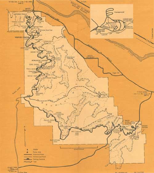
Balanced Rock, Coke Ovens, Sentinel Spire, Independence Monument, and Window Rock are but a few of the features you can see along 22-mile Rim Rock Drive, which skirts the walls of Red, Ute, No Thoroughfare, and Monument Canyons. To the north and northeast, the Book Cliffs form the skyline and mark the north side of Grand Valley. Grand Mesa looms to the eastward.
SAFETY SUGGESTIONS WHILE VISITING HERE
Ask for advice and information.
The road through the park is narrow and winding. Do not stop along the road except at designated pullouts.
Do not touch, feed, or molest animals. Even small animals can inflict a painful bite.
Don't hike or climb alone. Please register for all technical climbs.
Watch your children around the canyons and ledges.
Never throw or roll rocks into the canyons. Someone may be below you.
Report trouble to a park ranger—whether yours or someone else's.
YOUR SAFETY and YOUR CHILDREN'S SAFETY areof primary concern to us.
THE MONUMENT'S GEOLOGY
Moisture and frost action, loss of cementing agents between sandstone grains, temperature variations, the work of flood waters after heavy thunderstorms, and, above all, sapping or undercutting have formed these canyon landscapes.
At Colorado National Monument, you can stand at a number of points and see fine examples of rocks of many eras of geological time—from the ancient rocks of the Precambrian (over a billion years old) to the lava flows capping Grand Mesa, east of the monument, which were erupted less than a million years ago.
The core of the Uncompahgre Highland was composed of crystalline rock—granite, gneiss, schist, and pegmatite dikes—belonging to the Precambrian. Hundreds of millions of years elapsed as the highland eroded away. During this period, its surface was covered alternately with stream and lake deposits and with dunes of windblown sand. Then, at about the time the Rocky Mountains were being formed, tremendous earth forces lifted the Uncompahgre Plateau above the surrounding country.
Small canyons began to take form. Undermining of softer sections of sandstone layers caused them to break off continually, thus deepening and widening the canyons. As weathering continued, the thin ridges were cut through, and fractures or joints widened, leaving isolated columns of rocks or monoliths such as Independence Monument.
Great rock displacements, associated with the mountain-making uplifts in the Rocky Mountain region, cracked the crust of the earth to form a 10-mile-long fault. Today this forms a conspicuous escarpment, hundreds of feet high, that crosses the monument and constitutes one of its more spectacular features.
Rapid runoff from each summer shower pushes more mud and sand down the Colorado River drainage toward the sea. During the ice age the rainfall was probably much heavier than today's average of about 11 inches annually. The Colorado River must have been a much more formidable stream than it is now when it drained the many melting glaciers of the mountains to the east.
Nonetheless, despite today's aridity, Nature is removing rock, grain by grain, and is still carving the fantastic monoliths, open caves, and other forms that characterize Colorado National Monument.

PREHISTORY AND HISTORY
The artifacts, burials, and habitations found throughout most of the Southwest indicate that prehistoric basket-makers once lived in the area that includes Colorado National Monument.
The Ute Indians were the more recent inhabitants of this area. They occupied western Colorado when modern man first appeared.
Fray Francisco Atanasio Dominguez, accompanied by Fray Silvestro Velez de Escalante and nine others, five of whom were soldiers, representing the authority of Spain, set out from Santa Fe for Monterey, Calif., on July 29, 1776. According to Escalante's journal, the party passed north of the site of the present monument about August 27.
Antoine Robidoux, a Frenchman from St. Louis, established a trappers' supply and Indian trading post in the 1830's near present-day Delta, Colo. (about 60 miles south of the monument). Unquestionably many trappers, including the famous Kit Carson, who visited Fort Robidoux, passed by what is now Colorado National Monument.
The modern story of the monument starts around the turn of the century when John Otto, a wanderer and visionary, settled in Monument Canyon.
Otto was a trailblazer who built roads and trails throughout the area. Not satisfied with his private enjoyment of the beauties of the red-and-tan canyon walls, he turned to publicizing them—by writing letters to interest people in setting aside the scenic area for the public. By 1907, he had aroused sufficient interest for a petition to be drawn up asking the Secretary of the Interior to consider preserving the area as a public park.
Otto's dreams came true; on May 24, 1911, President William Howard Taft signed a proclamation establishing the monument. Otto was named its first custodian.
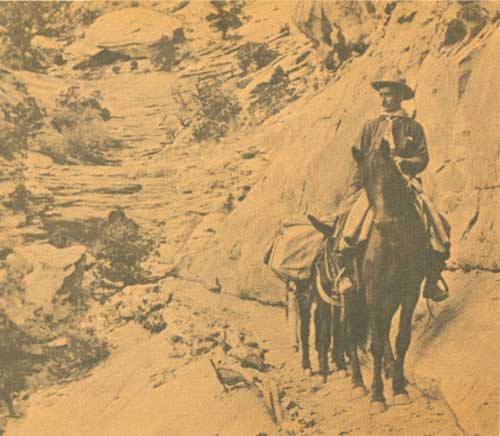
John Otto
FLORA AND FAUNA
Wildflowers dot early spring and late summer landscapes; bright cactus blossoms and creamy spikes of yucca are particularly conspicuous. The forest cover is chiefly Utah juniper and pinyon pine, interspersed with such brushy and shrubby plants as sagebrush, serviceberry, and mountain-mahogany.
The monument is a wildlife sanctuary; deer, foxes, and bobcats live in the area. American elk (wapiti) and cougar are seen occasionally. Birds of many species are heard and frequently seen.
As you drive through the pinyon pine-juniper forest, notice that many pinyons have been damaged by porcupines. The inner bark is eaten by them when winter snows cover low-growing plants on which they normally feed.
The collared lizard is so named because of the black band encircling its neck. This 14-inch-long lizard, with its green body and yellow head and feet, is the most colorful of the nine species of lizards found in the monument.
In 1926, three bison were transplanted from the Denver Mountain Parks. The herd, now maintained at about 10 head because of the sparseness of forage, are occasionally seen in the canyons from Rim Rock Drive or from Redlands Road, grazing along the base of the escarpment.
HELP PROTECT YOUR MONUMENT
Natural features—Picking, disturbing, or damaging flowers, trees, or other plants, or removing rocks, minerals, or any other things native to the monument is prohibited.
Defacing signs, buildings, or other structures is illegal.
Fires—You must obtain permission from the ranger office to build fires in other than the campground and picnic fireplaces. Do not cut wood for use in the fireplaces; use—and sparingly—wood prepared and placed there. Make sure your campfire is out before you leave it.
Litter—Please put refuse in containers provided.
Throwing or rolling rocks or other objects into the canyons is destructive to the monument's natural beauty and endangers persons below.
Hiking and climbing—Check with a ranger on trail conditions or before climbing. Never hike or climb alone.
Pets must be under physical control at all times and are not allowed in public buildings or on park trails.
Maximum speed is 35 miles per hour. Reduce speed on sharp and blind curves. Do not park on the road or road shoulders—use turnouts provided.
Hunting is not allowed and firearms must be unloaded and cased.
(click on image for a PDF version)
ABOUT YOUR VISIT
The monument is 4 miles west of Grand Junction and 3-1/2 miles south of Fruita, Colo. Frontier and United Airlines and the Denver and Rio Grande Western Railroad serve Grand Junction. Continental Trailways buses serve both towns.
Special sightseeing trips are scheduled in summer from Grand Junction; for information, write Grand Junction and Fruita chambers of commerce. Cars may be rented at Grand Junction.
The monument is easily accessible by highway: U.S. 6, 24, 50, and I-70 to Grand Junction; and U.S. 6, 50, and I-70 to Fruita.
Nature walks and evening programs are scheduled during the summer. Schedules are posted in public-use areas.
At the Saddlehorn is a campground (no reservations) and picnic area, with tables, fireplaces, water, firewood, and restrooms. Near the east entrance is a picnic area with shelter, restrooms, charcoal grills, and tables. Food, gasoline, and camping supplies are not available in the monument, but they are at Grand Junction, Fruita, and the Glade Park Store. Overnight accommodations are available in Grand Junction and Fruita.
In the visitor center exhibits explain the prehistory, history, and natural history of the monument. Inquire of the superintendent for times the visitor center is in operation and the services available.
Window Rock, Coke Ovens, and Serpent's Trail self-guiding trails provide short, enjoyable walks along the canyon rims. Leaflets explain trailside features. Monument Canyon trail is longer. See a ranger for information on other trails. Before taking the longer trails, tell a ranger at headquarters your hiking plans. In summer, be sure to take water.
Administration—Colorado National Monument, 28 square miles in area, is administered by the National Park Service, U.S. Department of the Interior. A superintendent, whose address is Colorado National Monument, Fruita, CO 81521 is in immediate charge.
As the Nation's principal conservation agency, the Department of the Interior has responsibility for most of our nationally owned public lands and natural resources. This includes fostering the wisest use of our land and water resources, protecting our fish and wildlife, preserving the environmental and cultural values of our national parks and historical places, and providing for the enjoyment of life through outdoor recreation. The Department assesses our energy and mineral resources and works to assure that their development is in the best interests of all our people. The Department also has a major responsibility for American Indian reservation communities and for people who live in Island Territories under U.S. administration.
National Park Service
U.S. DEPARTMENT of the INTERIOR
| <<< Previous | <<< Contents>>> |
1975/colm/sec1.htm
Last Updated: 20-Jun-2010