|
Capitol Reef
Cultural Landscape Report |

|
ANALYSIS AND EVALUATION (continued)
VEGETATION RELATED TO LAND USE (continued)
(Orchard Summaries)
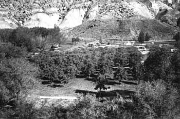
Current Name: Chesnut Orchard
Other Name(s): Upper Chesnut Orchard
Park Code: 0-15
Location: Approximately 1.5 miles from the visitor center between the Fremont River and the Loop C Campground.
Tract: 2
Acres Cultivated:
| Orchard | 2.8 |
| Field | 0 |
| Total | 2.8 |
Number of Trees: 129
Date Recorded: January 1992, March 1993
| |
| Chesnut Orchard | |
Historical Documentation:
Originally part of the Nels Johnson homestead, Johnson's descendants sold 53.76 acres to William Chesnut in 1925. The land remained in the Chesnut family until it was sold to the government in 1962. Documentation suggests that in 1940, Chesnut had approximately 6.4 acres in orchard, filling the land between the Fremont River and the Scenic Drive. In 1987, 3.6 acres of orchard were removed to construct Loop C Campground.
Historic Crops:
Peach (434)
Apple (84)
Pear (30)
Current Crops:
Almond (25)
Apple (75)
Red Delicious
Yellow Delicious
unknown varieties
Pear (29)
Bartlett
| <<< Previous | <<< Contents >>> | Next >>> |
http://www.nps.gov/care/clr/clr4d15.htm
Last Updated: 01-Apr-2003