|
Capitol Reef
Cultural Landscape Report |

|
ANALYSIS AND EVALUATION (continued)
VEGETATION RELATED TO LAND USE (continued)
(Orchard Summaries)
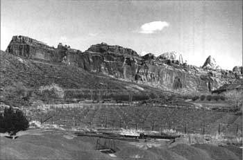
Current Name: Carrell Orchard
Other Name(s): Mulford Pasture
Park Code: 0-18
Location: Approximately 1.5 miles from the visitor center, south of Cal Pendleton Field, west of the Scenic Drive, and east of the Group Campsite.
Tract: 1
Acres Cultivated:
| Orchard | 2.1 |
| Field | 0 |
| Total | 2.1 |
Number of Trees: 266
Date Recorded: December 1991, March 1993
| |
| Carrell Orchard | |
Historical Documentation:
Originally part of the Hyrum Behunin homestead, this land was part of a tract owned from 1915 to 1920 by the Pendleton family. Cass Mulford acquired 56.5 acres in 1922 and added another 88 acres (purchased from J. Jorgensen) in 1929. Mulford owned the 144.5-acre tract from 1922 to 1962, when it was sold to the NPS. This orchard is located in a portion of what was Cass Mulford's pasture, south of the orchard. The orchard historically covered only 1 acre, with almost 2 acres in field crop. Approximately .8 acres were lost to the development of the Group Campsite in 1987. The current orchard was planted in 1987 and 1988.
Historic Crops:
undocumented
Current Crops:
Peach (266)
Elberta
Hale
| <<< Previous | <<< Contents >>> | Next >>> |
http://www.nps.gov/care/clr/clr4d19.htm
Last Updated: 01-Apr-2003