|
Fort Vancouver
Cultural Landscape Report |

|
II. FORT VANCOUVER: TRANSITION, 1829-1846 (continued)
Site
(continued)
Land Use
The acreage comprising Fort Vancouver was used for farming and for industries associated with the export trade. Because different lands became more intensively farmed as this period progressed, the changes on each plain, as so far as is known, are discussed under the subheading of each. This is a discussion of the general uses of the entire site.
Most development appears to have radiated outwards from the 1828-29 stockade. Land use patterns tended to follow the functional possibilities presented by naturally occurring resources. As noted previously, it appears the stockade site was selected for its proximity to the river, while avoiding the almost yearly spring freshets. The garden and orchard, which provided food for the "gentlemen's" table, were established next to the stockade. The village where the company servants lived was in close proximity to where they worked, if they were mechanics, and where they received supplies, if they were part of the fur brigades. Grist and sawmills were located on naturally occurring streams near the river to provide power and transportation of both raw and finished materials. Pasturage was selected, to a great extent, for the availability of grass. Cultivated fields were primarily found where the land was assessed as "good," or fertile enough to sustain crops, and structures associated with farming, such as barns and storage sheds, were located near these fields.
In 1838, Chief Trader James Douglas prepared an inventory of the number of acres of arable land on the farm, which, when totaled, equals 861 acres. [423] This total does not agree with the numbers presented by two others in or around the same year. The fort's postmaster between 1836 and '38, John Dunn, later wrote that the farm consisted "...of about three thousand acres; of which about fifteen hundred have already been brought to the highest state of tillage. It stretches behind the fort, and on both sides, along the banks of the river." [424] John Sinclair's April 1838 report stated that the farm "...contains...about 3,000 acres of land, fenced and under cultivation." [425]
Assuming Douglas, who was in charge of Fort Vancouver then, was fairly close in his approximations, the farm at Fort Vancouver in 1838 included the following acreage, which Douglas deemed arable. On Fort Plain, he reported a total 457 acres of cultivable land. On what Douglas called the West Plain, which was the open meadow on Lower Plain south of Big Lake and east of the smaller chain of lakes to its south, he reported a total of 184 acres. On the First North Plain, which was probably First Back Plain, there were 100 acres of poor land, and on Second North Plain, probably Second Back Plain, there were 120 acres of "poor land." The Mill Plain farm had not yet been established at the time of the inventory. From harvest figures of 1836 and 1840, we know that crops planted on this land included wheat, the principal crop at the farm; oats; barley, and peas. It appears that potatoes were cultivated in these years--they were shown as a field on the map in 1844, and mentioned by visitors--but no known records of the potato crop production between 1836 and 1844 exist. [426] Indian corn returns cease to be reported after 1833, and since several visitors, in addition to McLoughlin, reported that Indian corn "faired poorly," it seems probable that little, if any acreage was devoted to its cultivation after that date.
Douglas also reported in 1838 that an acre of land would yield "...20 bushels Wheat or 30 Bus Pease or 50 Bus Oats or 40 Bus Barley and the poorer soils yield 100 percent less." If that was true, then, working backwards, one can very roughly approximate the number of acres in cultivation, and thus the development of the farm. Using the harvest figures reported by Henry Spalding in 1836, for example, one can calculate that in 1836, if all "good land" was used, approximately 430 acres were in production of grains. Applying this method, one can see that the number of acres in production almost trebled between 1827 and 1828; held steady for several years, and then increased by a quarter or so in 1831. In 1832, the year visitors reported the farm operations had expanded, the minimum amount of land in production doubled over the previous year, and by 1836 had increased by a quarter again. Harvest figures reported for 1836 show four to five thousand bushels of wheat, fifteen hundred to two thousand bushels of oats, the same number bushels of barley, and about four thousand bushels of peas were gathered at Fort Vancouver. The number of potatoes harvested was not reported that year, nor is corn mentioned. From that year through 1846, it appears the overall harvest, in terms of bushels, increased only slightly, where figures are available. The Mill Plain Farm was established around 1841, but unfortunately complete harvest figures for that year, 1842 and 1843 have not, to date, been found. In 1844, by which time about one thousand acres were under cultivation at Mill Plain Farm, the harvest figures are approximately equal to those reported in 1836. It seems that the amount of acreage under cultivation was approximately the same.
|
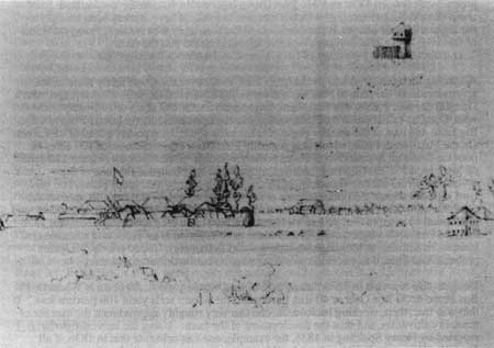
| Figure 2. Sketch of Fort Vancouver and part of Fort Plain, looking southwest, c. 1846, by artist Paul Kane. Original in Royal Ontario Museum, University of Toronto. |
The most logical explanation for the approximate equal size of the crops in 1836 and 1844, despite the establishment of Mill Plain Farm, is that the Company abandoned all or part of its cultivation on the West Plain Farm on Lower Plain. There is some historic evidence to support this supposition. Merchant M.T. Simmons, who arrived at the Columbia in 1844, noted that Fort Vancouver "had three farms under cultivation and fenced in; there had been a fourth, but the fences and barns had been burnt up in 1844." [427] It seems probable that the 1844 fire, which destroyed fences and structures at the West Plain Farm were never replaced, which accounts for almost two hundred acres.
In 1839, the number of cattle at Fort Vancouver doubled from the amount reported in 1838, and increasing numbers of sheep were being imported from England, as well as from California. Many head were ultimately destined to be driven to Fort Nisqually and Cowlitz Farm, as part of the Puget's Sound Agricultural Company, but occasionally weather or labor availability required that the livestock be held at Fort Vancouver for some months. It appears from the historic literature, that the additional livestock were pastured primarily on the edges of the Mill Plain farm, and on Lower Plain, although there are some references to grazing livestock on Fort Plain in the 1840s.
| <<< Previous | <<< Contents >>> | Next >>> |
fova/clr/clr2-2c2.htm
Last Updated: 27-Oct-2003