
|
Geological Survey Bulletin 1229
Geology of the Circle Cliffs Area, Garfield and Kane Counties, Utah |
STRATIGRAPHY
Sedimentary rocks exposed in the map area total 8,500 feet in thickness. The oldest rocks that crop out are Permian and probably are best correlated with the Cutler Formation, well known from its outcrop in the Henry Mountains region to the east. The youngest rock unit, except Tertiary and Quaternary alluvial and colluvial deposits, is the mesa-capping Mesaverde Formation of Late Cretaceous age.
Rocks of continental, littoral, and marine origins are present. Sandstone of continental fluvial and eolian origin composes part of the White Rim Sandstone Member of the Cutler Formation, the Wingate, Navajo, Entrada, and Dakota Sandstones, and the Morrison Formation. Sandstone and siltstone of marine or littoral origin compose part of the White Rim Sandstone Member, the Moenkopi, Carmel, Summerville, and Mesaverde Formations, the Entrada and Dakota Sandstones, and the Mancos Shale. Dolomite deposits of marine origin compose the Kaibab Limestone and the Sinbad Limestone Member of the Moenkopi Formation.
Tertiary and Quaternary rocks in the area may be divided generally into alluvial and colluvial deposits. The mapped alluvial deposits are fan deposits in the northern part of the area, bouldery deposits and pediment deposits near Boulder Mountain, windblown sand, and stream alluvium. The mapped colluvial deposits are talus cones and landslide deposits. The landslide deposits include large rotated blocks (some of which are Toreva blocks), mudflows, and other types of landslide material.
The total thickness of the sedimentary rocks overlying the basement rock is not known from direct evidence, such as outcrops or oil tests. Two oil-test wells, both unsuccessful producers, were drilled in the Circle Cliffs area at almost the same location (pl. 1, sheet 1). The Ohio Oil Co. Government 1, drilled in 1921 (Gregory and Moore, 1931, p. 156-157), spudded near the top of the Kaibab Limestone half a mile west of Wagon Box Mesa and was completed at a total depth of 3,212 feet. The N. B. Hunt Government 1, drilled in 1953-54, spudded in the lower part of the Moenkopi Formation near the north end of Wagon Box Mesa and penetrated 5,628 feet of Triassic, Permian, Pennsylvanian, Mississippian, Devonian, and Cambrian rocks (Steed, 1954, fig. 1, p. 100-101). A few miles east of the mapped area, the California Co. Muley Creek 1, a test of the Muley Creek anticline, penetrated Jurassic to Devonian rocks.
The following generalized section briefly describes all exposed sedimentary rocks in the Circle Cliffs area.
Generalized stratigraphic section of sedimentary rocks exposed in the Circle Cliffs area
| System | Series | Group, formation, and member |
Thickness (ft) |
Lithology | ||
| Quaternary, Tertiary (?), and Tertiary | Alluvial and colluvial deposits | Gravel, sand, silt, and bouldery deposits. | ||||
| Unconformity | ||||||
| Cretaceous | Upper Cretaceous | Mesaverde Formation | 400 | Light-brown cliff-forming sandstone and gray mudstone interbeds; intertongues with Masuk Member of Mancos shale. | ||
| Mancos Shale | Masuk Member | 700-900 | Gray silty mudstone and light-gray sandstone interbeds that increase in quantity upward. | |||
| Emery Sandstone Member | 120-300 | White crossbedded lenticular sandstone, coaly mudstone light-yellow fine-grained even-bedded sandstone; intertongues with Blue Gate Shale Member. | ||||
| Blue Gate Shale Member | 1,200-1,500 | Bluish-gray finely laminated mudstone, some bentonitic clay, shaly sandstone, and limestone beds. | ||||
| Ferron Sandstone Member | 200-350 | Brown fine-grained ripple-laminated sandstone, white crossbedded sandstone, and gray mudstone interbeds; uppermost part contains coal beds; intertongues with Tununk Shale Member of Mancos Shale. | ||||
| Tununk Shale Member | 550-650 | Dark-gray mudstone to slightly fissile shale; gradational with Dakota Sandstone. | ||||
| Upper Cretaceous and Lower (?) Cretaceous | Dakota Sandstone | 100-150 | Yellowish-brown to gray mudstone and yellowish-brown fossiliferous sandstone; few coaly mudstone beds; white sandstone and coaly mudstone in lower part. | |||
| Unconformity | ||||||
| Jurassic | Upper Jurassic | Morrison Formation | Brush Basin Shale Member | <100-300 | Variegated mudstone and claystone, minor sandstone and conglomerate. | |
| Salt Wash Sandstone Member | 300-450 | White medium-grained sandstone and reddish- to greenish-gray mudstone; lenticular to tabular bedding. | ||||
| San Rafael Group | Summerville Formation | 50-190 | Red to brown ribbed siltstone, mudstone; brown to white fine-grained sandstone. | |||
| Curtis (?) Formation | 0-5 | White discontinuous calcareous sandstone to sandy limestone. | ||||
| Unconformity | ||||||
| Entrada Sandstone | Upper sandy member | 170-250 | White and brown thin-bedded sandstone to brown massive cliff-forming sandstone. | |||
| Medial silty member | 320-360 | Reddish-brown siltstone, very fine grained sandstone, and mudstone. | ||||
| Lower sandy member | 210-365 | Brown massive very fine grained to fine-grained sandstone with large-scale crossbeds. | ||||
| Upper Jurassic and Middle Jurassic |
Carmel Formation | 200-300 | Upper unit: red gypsiferous soft earthy siltstone; gypsum beds decrease
in quantity to south. Lower unit: bright-red siltstone and minor sandstone and yellowish-gray to pink limestone interbeds. | |||
| Jurassic and Triassic (?) | Glen Canyon Group | Navajo Sandstone | 950-1,400 | White massive cliff-forming sandstone with large-scale crossbeds. | ||
| Triassic (?) | Upper Triassic (?) |
Kayenta Formation | 250-400 | Reddish-brown thin- to thick-bedded sandstone and siltstone; some mud-chip conglomerate, calcareous sandstone, and light-yellow limestone beds. | ||
| Triassic | Upper Triassic |
Wingate Sandstone | 230-350 | Light-brownish-orange cliff forming very fine-grained to fine-grained sandstone; large-scale crossbeds. | ||
| Unconformity | ||||||
| Chinle Formation | Church Rock Member | 0-25 | Brown massive fine- to medium-grained sandstone. | |||
| Owl Rock Member | 150-250 | Red, brown, and greenish-gray sandstone and mudstone; greenish-gray thin lenticular limestone beds. | ||||
| Petrified Forest Member | 150-350 | Variegated bentonitic mudstone and sandstone. | ||||
| Monitor Butte Member | 100-200 | Green and minor grayish-red bentonitic mudstone; gray to light-brown ripple-laminated fine-grained micaceous sandstone. | ||||
| Shinarump Member | 0-250 | White medium-grained thin to thick crossbedded sandstone; interbedded white thin-bedded sandstone greenish-gray mudstone, and light-yellow very thick bedded sandstone; contains carbonaceous and charcoaly material. | ||||
| Unconformity | ||||||
| Mottled-siltstone unit | 0-50 | Mottled red and white siltstone with medium sand-size quartz fragments; hackly vertical fracture; well cemented; locally includes at base a mottled red and white fine-grained sandstone. | ||||
| Unconformity | ||||||
| Middle (?) Triassic and Lower Triassic | Moenkopi Formation | Upper ledge-forming unit | 0-45 | Reddish-brown mudstone and yellowish- to greenish-gray sandstone, dolomite, and dolomitic sandstone interbeds; forms ledgy slope and cliff. | ||
| Slope-forming unit | 0-250 | Reddish-brown siltstone and minor thin sandstone beds; slope forming. | ||||
| Lower ledge-forming unit | 200-245 | Reddish-brown ledge- and bench-forming interlayered sandstone and siltstone; light yellow to dark gray on weathered surface where saturated with oil or asphalt. | ||||
| Lower Triassic | ||||||
| Sinbad Limestone Member | 0-120 | Brownish- to yellowish-orange oolitic fossiliferous dolomite and conglomeratic dolomitic sandstone. | ||||
| Unconformity | ||||||
| Basal unit | 0-25 | White to light-gray fine-grained dolomitic sandstone to sandy dolomite; abundant fragments of white chert; local abundant bedded white chert. | ||||
| Unconformity | ||||||
| Permian | Kaibab Limestone | 0-60 | Light-yellow thin-bedded dolomite; contains specks of green glauconite and collophane. | |||
| Cutler Formation | White Rim Sandstone Member | Upper unit | 65-155 | White thin- to thick-bedded dolomitic sandstone and minor sandy dolomite? interbeds. | ||
| Lower unit | 108+ | White very thickly crossbedded fine-grained sandstone; medium- to large-scale crossbeds; base not exposed. | ||||
PERMIAN SYSTEM
Rocks of Permian age crop out only in deep canyons in the interior of the Circle Cliffs area, and they consist of, in ascending order, a white sandstone with large-scale crossbeds, a tabular stratified dolomitic sandstone—both of which probably are equivalent to the White Rim Sandstone Member of the Cutler Formation—and the Kaibab Limestone. The total thickness of Permian rocks, as known from the N. B. Hunt oil-test well, is about 2,300 feet.
Facies changes, origin, and correlation of Permian and older Paleozoic rocks of the Kaiparowits region were summarized by Heylmun (1958).
CUTLER FORMATION
The name Cutler Formation was given by Cross and Howe (1905) to a series of red beds near Ouray, Colo., that overlies the Rico Formation and is unconformably overlain by the Dolores Formation. The Cutler has been traced into the Henry Mountains region, where it is overlain by the Moenkopi Formation and underlain by the Rico (Baker and Reeside, 1929; Hunt and others, 1953, p. 37-40). Three members of the Cutler crop out in the eastern part of the Henry Mountains region. These are, in ascending order, the Cedar Mesa Sandstone Member, the Organ Rock Tongue, and the White Rim Sandstone Member. Hunt followed Gilluly and Reeside (1928, p. 63) and Gregory and Moore (1931, p. 40) in assigning a correlative sandstone in the western part of the Henry Mountains region to the Coconino Sandstone. The Coconino was named by Darton (1910, p. 21, 27) from exposures of crossbedded sandstone in the Grand Canyon region, where the sandstone is overlain by the Kaibab Limestone and underlain by rocks of Pennsylvanian age. The crossbedded sandstones of the Circle Cliffs and Capitol Reef areas and the San Rafael Swell, occupying similar stratigraphic positions, were correlated with the Coconino of the Grand Canyon area. This correlation has been questioned (McKee, 1954b; Stewart and others, 1959, p. 494) because the formation does not crop out continuously between the Circle Cliffs and the Grand Canyon areas, because bore holes are few, and because the Coconino progressively thins northward to a pinchout near the Arizona-Utah State line.
I suggest that the name Coconino Sandstone be dropped in favor of Cutler Formation in the Circle Cliffs area. This usage follows that of Steed (1954, p. 100-101) and Heylmun (1958, p. 1792). Steed correlated subsurface red beds in the central part of the Circle Cliffs "Coconino" with the Organ Rock Tongue of the Cutler Formation. These red beds occupy a stratigraphic position similar to that of the Organ Rock Tongue and are markedly dissimilar to the overlying and underlying quartzose sandstones, in that they are slightly arkosic and micaceous. Parts of the Coconino and Cutler are probably time equivalents, but the name Cutler is more appropriate for the sandstone beds underlying the Kaibab Limestone in the Circle Cliffs area.
The White Rim Sandstone Member of the Cutler, as herein defined and as shown on plate 1, consists of two units in the Circle Cliffs area. Both units are sandstone, and their total thickness is about 500 feet in the N. B. Hunt Government 1 well near the north end of Wagon Box Mesa.
The lower unit, of which a maximum of 108 feet is exposed in a tributary to Muley Twist Canyon, is white quartzose sandstone that is cross-stratified on a medium to large scale. The sandstone is very friable and only slightly calcareous. It is composed of well-sorted very fine to fine subangular and angular grains of frosted quartz sand with very minor amounts of plagioclase, microcline, muscovite, chert, tourmaline, and zircon (?). The contact between the lower and upper units of the White Rim is sharp and easily identified in the eastern part of the Circle Cliffs area; but in White Canyon, where almost 80 feet of the lower unit should be exposed, it intertongues with the upper unit so that a contact between the two cannot be picked. The crossbedded nature of the lower unit indicates eolian deposition, probably at the edge of a Kaibab sea; the crossbeds dip generally south, indicating that the prevailing wind at the time of deposition was from the north.
The upper unit of the White Rim Sandstone Member is horizontally stratified thin- to thick-bedded dolomitic sandstone with a few sandy dolomite beds. The total thickness of this unit increases from 66 feet in the easternmost stratigraphic section (section 2) to 154 feet in White Canyon (section 1). This increase almost certainly is gained through intertonguing with the underlying crossbedded sandstone. The upper contact is sharp and conformable; the upper most bed is almost everywhere a very poorly sorted very fine grained to medium-grained dolomitic sandstone about 5 feet thick, and is overlain by dolomite of the Kaibab Limestone containing 5 percent or less of quartz grains.
The upper unit was included in the Kaibab Limestone by Gregory and Moore (1931), McKee (1938), and Steed (1954). In the geologic map and stratigraphic sections accompanying this report, the upper unit is included in the White Rim Sandstone Member because it intertongues with that unit and because it is dominantly a sandstone, not a carbonate rock; thus, lithologically, it is more similar to the White Rim than to the Kaibab. The contact between the upper unit and the Kaibab is sharp, occupies the same stratigraphic position throughout the Circle Cliffs area, and can be identified with a fair degree of certainty from a reasonable distance. The lower contact, as explained above, cannot be identified as easily.
The sandstone beds of the upper unit are light yellow to grayish white and are friable to well cemented. The major constituent is quartz, which is accompanied by lesser amounts of dolomite cement and traces of feldspar, muscovite, chert, pyrite, and various opaque and nonopaque heavy minerals. Locally, some beds contain 1-5 per cent of heavy minerals. The sand grains are subrounded to rounded and dominantly very fine to fine. A few beds are composed of silt, and others contain coarse grains, but on the whole the sandstone is well sorted. The dolomite beds are pale yellow to yellowish brown and are generally fossiliferous. They show traces of oolitic structure, now largely destroyed by dolomitization. A sample of the uppermost dolomite bed measured near North Fork Creek (strat. section 4) was analyzed by Wayne Mountjoy, of the U.S. Geological Survey, who reported (written commun., 1956) a 1.57 calcium: magnesium ratio in the soluble carbonate; X-ray diffractograms completed by A. J. Gude 3d (written commun., 1965) showed that the sample comprised about 70 percent dolomite, 20 percent quartz, and 10 percent calcite. The dolomite beds contain as much as 10 percent quartz grains and as much as 1 percent pyrite crystals, some altered to hematite. Locally, quartz geodes lined with crystals of calcite and quartz are abundant, and some of the geodes may be filled or partly filled with asphaltic material.
Fossils in the dolomite beds are fragments or molds of gastropods and pelecypods, bryozoans, crinoid stems, brachiopods, scarce trilobites, and sparse molds of sponge spicules. In places some of the fossil fragments are replaced by collophane.
All fossils reported from the Kaibab Limestone by McKee (1938, p. 212) were collected from the upper unit, and every Kaibab lot reported by Gregory and Moore (1931, p. 42-43), except the upper collection of lot 4382, is from this unit. Fossils collected during the present study were identified by E. L. Yochelson, of the U.S. Geological Survey, who reported (written commun., 1956): "incomplete trilobite pygidium, cf. Ditomopyge or Delaria, and Permophorus sp., probably not P. albequus" from the upper 10 feet; "Permophorus sp. (large; common); fragments of gastropods, indeterminate (two genera)" from the uppermost dolomite layer about 8-15 feet below the top of the unit; "myalinid pelecypod, pectinoid pelecypod, Permophorus sp., and ?Schizodus sp." from sandstone below the uppermost prominent dolomite bed about 15-25 feet below the top of the unit. The fossils are of marine origin but are not diagnostic in determining the age of the unit, according to Yochelson.
The presence of marine fossils, the westward thickening and accompanying intertonguing with the underlying crossbedded sandstone, and the lithologic characteristics all lead to the conclusion that the upper unit of the White Rim is a transgressive marine deposit formed as Permian seas encroached to the east. In the western area of its outcrop the formation seems to contain more carbonate than in other areas; a few miles west of the Circle Cliffs area it probably is indistinguishable from the overlying Kaibab Limestone.
KAIBAB LIMESTONE
The Kaibab Limestone (Darton, 1910, p. 21-30), originally named the Aubrey Limestone by Gilbert (1875, p. 176-185, 187), is a thin-bedded light-yellow dolomite in the Circle Cliffs area. It is about 45 feet thick in most of the area and has a maximum thickness of about 60 feet, in White Canyon.
The Kaibab is absent in the southern and southeastern areas of Permian outcrop owing to erosion in Late Permian to Early Triassic time. It is missing also in the California Co. Muley Creek 1 (Alexander and Clark, 1954) on the crest of the Muley Creek anticline and in outcrop areas to the east in the Henry Mountains region. The formation thickens 10-15 feet, probably in the upper half, from the eastern to the western parts of the Circle Cliffs area. This trend of thickening is probably due to gradually less severe post-Kaibab erosion to the west.
The lithology of the Kaibab is virtually the same throughout the Circle Cliffs area. The formation is a thin-bedded very fine-grained to fine-grained oolitic porous dolomite. Most of the oolitic structure is poorly displayed, probably because of dolomitization. The formation as a whole is very light yellow, but beds range from white to brown. A few 1/4-3/8-inch layers of green glauconitic feldspathic sandstone separate massive beds of dolomite. Three samples of the Kaibab, collected from widely separated locations, were analyzed by Wayne Mountjoy, who reported (written commun., 1956) that calcium: magnesium ratios in the carbonate mineral ranged from 1.27 to 1.44. X-ray diffractograms of the same samples made by A. J. Gude 3d (written commun., 1965) showed that the carbonate was dolomite. Pyrite cubes, feldspar grains, and shreds of muscovite (?) occur in the unit in trace quantities. The Kaibab erodes to a ledgy slope in most of the area and is generally poorly exposed. In some places the upper part of the Kaibab contains moderate amounts of quartz geodes, stringers of bedded gray chert, and gray chert nodules and fragments. A very persistent marker bed about 20-25 feet above the base contains abundant bedded and fragmental gray chert and fine quartz sand. These siliceous deposits may be slightly more abundant in the eastern part of the Circle Cliffs area than in other parts. Where chert is especially abundant the contact between the Kaibab and the overlying unit is difficult to identify. Characteristics that distinguish the Kaibab from overlying and underlying formations are (1) abundant specks of green glauconite and collophane, (2) an almost complete absence of sandstone, (3) an abundance of sponge spicule casts.
The Kaibab Limestone is fossiliferous and in places contains beds of coquina as much as 6 inches thick. Fossils collected from the lower part of the Kaibab and identified by E. L. Yochelson, of the U.S. Geological Survey (written commun., 1954, 1955), include:
crinoid columnals, ?monaxon sponge spicules, productoid brachiopod cf. Juresania, pectenoid pelecypod, Permophorus aff. P. subcostatus (Meek and Worthen), Permophorus cf. P. Albequus (Beede), Permophorus sp. (large), a small subulitid gastropod, and a generically indeterminate fragment of a gastropod that had revolving ornamentation.
In a collection made about 6 feet below the upper contact, Yochelson (written commun., 1956) identified:
crinoid columnals, an indeterminate nuculoid pelecypod, ?Astarttella sp. indet., ?Schizodus sp. indet., Permophorus sp. indet. (small), ?Aviculopecten sp. indet., an euomphalid gastropod, an indet. gastropod, ?Composita sp. indet., and a spinose productoid brachiopod cf. Juresania.
Remains of a lithistid sponge were examined by R. M. Finks, Department of Geology, Queens College, New York, who reported (written commun., 1956) that the sponge probably represents a new genus and species occurring also in the Leonard and Word Formations of the Glass Mountains, Texas; according to Helen Duncan, of the U.S. Geological Survey (written commun., 1956), this sponge is probably not the sponge common in the Kaibab Limestone of the Grand Canyon area.
The Kaibab of the Circle Cliffs area is entirely of marine origin, and the uniform lithology of the formation leads to the opinion that the original eastern edge of Kaibab deposition is to the east of the present outcrop area. The patterns of distribution and thickening of the unit indicate that the formation was tilted regionally to the west or northwest following its deposition, and that a slight angular unconformity separates it from overlying rocks.
PERMIAN-TRIASSIC UNCONFORMITY
The regional Permian-Triassic unconformity was discussed in some detail by McKee (1938, p. 54-61; 1954a, p. 33-36), Dake (1920, p. 66-74), and Longwell (1925). The exact horizon of this unconformity was somewhat arbitrarily chosen because of an abundance of unconformities and a dearth of diagnostic fossils in key beds. The Kaibab Limestone—or where it has been removed, the Cutler Formation—is unconformably overlain by a chert-rich unit, herein called the basal unit of the Moenkopi Formation, that ranges from a sandstone to a sandy dolomite; this basal unit is unconformably overlain by the Sinbad Limestone Member of the Moenkopi Formation. Overlying red beds of the Moenkopi are in smooth sedimentary contact with the Sinbad, and with the basal unit of the Moenkopi where the Sinbad is absent.
The unconformity between the basal unit and the Kaibab has a maximum relief of about 70 feet. It is irregular and hummocky. The bedding of rocks underlying the surface is not disturbed, so the surface is due to erosion by surface water and not to development of a karst topography.
TRIASSIC SYSTEM
Rocks of Triassic age in the Circle Cliffs area are the Moenkopi and Chinle Formations, and of Triassic(?) age, the Wingate Sandstone, Kayenta Formation, and the lower part of the Navajo Sandstone (fig. 2). These formations are largely continental in origin except for the Moenkopi Formation, which was deposited in a marine, near-shore marine, and fluviatile environment (Stewart and others, 1959, p. 499).
|
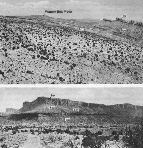
| FIGURE 2.—Triassic rocks in southeast Circle Cliffs. Upper figure shows Moenkopi Formation (Trm), Chinle Formation undifferentiated (Trcu), and Wingate Sandstone (Trw). Lower figure shows divide between Moody and Silver Falls Canyons. Moenkopi Formation (Trm), Shinarump Member of the Chinle Formation (Trcs), Chinle Formation undifferentiated (Trcu), and Wingate Sandstone (Trw). |
MOENKOPI FORMATION
To facilitate description and identification, the Moenkopi Formation is divided, in ascending order, into the basal unit, the Sinbad Limestone Member, the lower ledge-forming unit, the middle slope-forming unit, and the upper ledge-forming unit. Sources of the Moenkopi Formation were in west-central and southwestern Colorado, Southern Arizona and New Mexico, and northwestern Colorado (Wilson, 1958). Gradations of facies of the unit indicate a northwestward trend of drainage (Wilson, 1958) and a change from fluviatile to marine deposition.
BASAL UNIT
The basal unit of the Moenkopi Formation is white to light-gray fine-grained dolomitic sandstone to sandy dolomite and is 15-25 feet thick in most places. It contains abundant fragments of gray chert and in some places as much as 50 percent bedded chert. No fossils have been found in this unit, and its age is uncertain.
The basal unit is exposed mainly as a rubble of chert fragments capping benches and ledges of Kaibab Limestone. In the eastern and central parts of the Permian outcrop, it rests unconformably on either the Kaibab or, locally, beds of the White Rim Sandstone Member of the Cutler Formation as much as 8-10 feet below the top of the upper unit. Locally, where the basal unit is a dolomite and rests conformably on the Kaibab, the contact between it and the Kaibab appears gradational. In these places the basal unit resembles, and probably is at least in part, a residual deposit that grades almost imperceptibly downward from a sandy dolomite into the nearly pure dolomite of the Kaibab.
The basal unit does not crop out continuously in the east-central part of the Permian outcrop, and in the southeastern part of the Circle Cliffs area, in particular, its outcrop is very discontinuous. Here it is generally only 5-10 feet thick and in many places has been reworked and incorporated into a facies of the overlying Sinbad Limestone Member of the Moenkopi Formation. Although distinction of the two units is difficult in such places, the basal unit is generally characterized by abundant well-sorted fine-grained sandstone instead of the poorly sorted fine- to coarse-grained sandstone in the Sinbad, by white to gray color instead of the orange brown of the Sinbad, and by bedded chert, which is absent in the Sinbad. Erosion at the edges of the Sinbad sea removed this basal unit as well as the Kaibab in places.
In summary, the basal unit of the Moenkopi is both a fluvial and a residual deposit. It may be Permian or Triassic in age, but because of its extensive unconformable relation to the Kaibab, it is included in the Moenkopi Formation on the maps and stratigraphic sections accompanying this report.
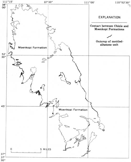
SINBAD LIMESTONE MEMBER
The Sinbad Limestone Member of the Moenkopi Formation rests on either the Kaibab or the White Rim Sandstone Member of the Cutler Formation in the southern and eastern areas of its outcrop; elsewhere except in one exposure it rests on the basal unit of the Moenkopi Formation. The basal contact is an erosional unconformity except in the northwest corner of the outcrop area, where a 5-foot-thick bed of green siltstone separates the Sinbad and the basal unit of the Moenkopi. The siltstone probably is equivalent to the red mudstone that separates the Sinbad from the Kaibab in the Capitol Reef area. In the Capitol Reef area the red mudstone thins markedly to the south toward the Circle Cliffs area before passing out of sight under younger rocks (Smith and others, 1963, p. 12).
The Sinbad Limestone Member grades from a conglomeratic dolomitic sandstone in the east to a dolomite in the west. It is commonly brownish orange to yellow orange. The Sinbad is as much as 120 feet thick, thin to thick-bedded, and locally crossbedded. Oolitic textures are very common, as are beds composed of a coquina of gastropod and other fossil fragments.
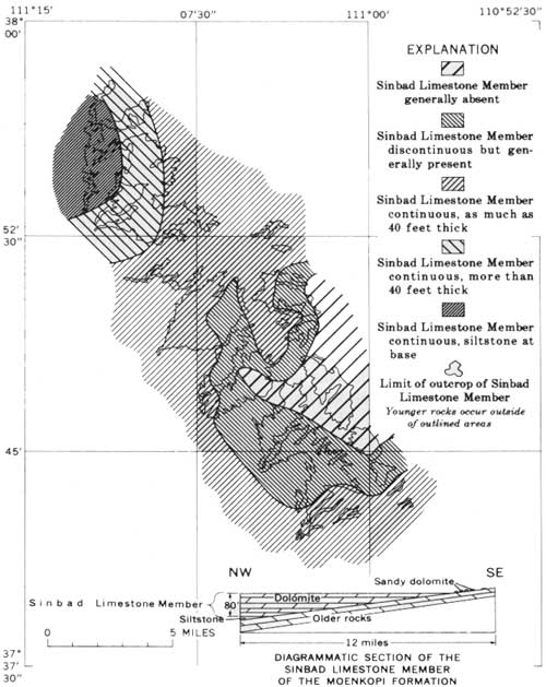
The Sinbad is absent in the eastern part of the Circle Cliffs area and thickens to about 80 feet in the northwestern part (fig. 3). It is about 120 feet thick in a tributary canyon between White Canyon and Horse Canyon. Crossbeds in sets 3-4 feet thick and 6-10 feet long are common, especially where the formation is sandy or oolitic. In areas where the outcrop is continuous, the Sinbad is a relatively pure oolitic dolomite containing only a small percentage of sand grains. A sample obtained from an outcrop 1 mile northeast of the northeast end of Wagon Box Mesa was analyzed by Wayne Mountjoy (written commun., 1956), who reported a 1.27 calcium: magnesium ratio in the soluble carbonate mineral. X-ray diffractograms completed by A. J. Gude 3d (written commun., 1956) showed that the carbonate was dolomite. In the eastern exposures, where the outcrops are discontinuous, the unit commonly is a sandy dolomite or a dolomite-cemented sandstone and locally is saturated with asphalt. The sandstone facies is conglomeratic and contains abundant fragments of gray chert which probably were derived from either the underlying basal unit of the Moenkopi or the Kaibab. The sandstone matrix is poorly sorted and fine to coarse grained and is composed of quartz and chert fragments.
|
| FIGURE 3.—Distribution of the Sinbad Limestone Member of the Moenkopi Formation in the Circle Cliffs area. Compiled by L. D. Carswell and E. S. Davidson, 1956-57. |
Fossils collected from the Sinbad consist mainly of fragments of pelecypods and gastropods that are not diagnostic for correlation or dating purposes. J. B. Reeside, Jr., and N. J. Silberling, of the U.S. Geological Survey, examined the collections and reported that they consist of indeterminate gastropods, pelecypods, algal debris, a radially ribbed dysodont pelecypod, and Aviculopecten? sp. According to Reeside (written commun., 1954), "this porous rock with gastropods is found at a number of places associated with Meekoceras and other Lower Triassic ammonites, and in my judgment is to be attributed to the Triassic rather than the Permian wherever it occurs in the Plateau region." Although the Meekoceras fauna has not been collected in the Circle Cliffs area, the dolomite unit is almost certainly equivalent to the Sinbad, and it is lithologically the same as the Sinbad of the Capitol Reef area from which the Meekoceras fauna was collected. The Meekoceras fauna is middle Early Triassic in age (McKee, 1954a, p. 15). The Sinbad of the Circle Cliffs area probably is also correlative with at least part of the Timpoweap Member of the Moenkopi Formation which crops out in the Grand Canyon area.
Oolitic texture, crossbedding, and coquina beds indicate that the Sinbad was deposited in a shallow-water marine environment. The eastern part of the Circle Cliffs area was at the edge of the Sinbad sea, near which the sandstone and conglomeratic facies were deposited.
LOWER LEDGE-FORMING UNIT
The lower ledge-forming unit of the Moenkopi consists of interlayered sandstone and siltstone beds that erode differentially, giving the outcrops a ledge-and-bench topographic expression. Normally, this unit is brownish red, but due to a widespread impregnation by oil or asphalt, and dependent on the asphalt content, the red rock is shaded from light grayish red to light gray or black. The most asphaltic rock is light yellow and locally dark gray in weathered outcrops. The unit is about 200-245 feet thick and grades into the overlying slope-forming unit of the Moenkopi. Ripple marks and small-scale crossbedding are common. The sandstone is largely quartz with some feldspar and mica and is cemented primarily with iron oxide.
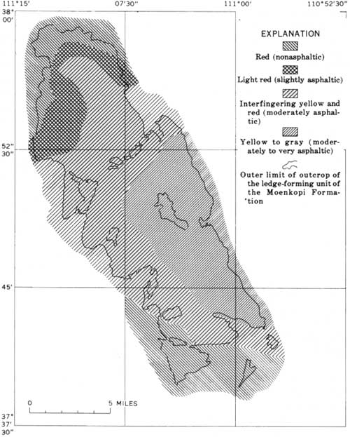
The lower ledge-forming unit is asphaltic in a considerable area of its outcrop (fig. 4); the asphalt content ranges from black rock oozing asphalt to light-grayish-red rock that shows only faint traces of asphalt. The rock that is moderately to heavily impregnated with asphalt contains abundant and widely disseminated pyrite, which is not present in the normally red Moenkopi, but may have originated through a combination of iron from the Moenkopi with sulfur from the intruded asphalt. The rock moderately impregnated with asphalt is light yellow in weathered outcrops, probably due to oxidation of the disseminated pyrite to a limonitelike material. Because of the reaction of the introduced pyrite to weathering, the rock outcrop color can be used to differentiate the degree of asphalt introduction. The yellow to gray rock is most asphaltic, the interfingered yellow and red rock is intermediate in asphalt content, and the light-grayish-red rock is only slightly asphaltic (fig. 4).
|
| FIGURE 4—Distribution of asphalt in the Moenkopi Formation. Compiled by L. D. Carswell and E. S. Davidson, 1956-59. |
The control and age of the asphalt introduction cannot be determined directly, but several observations may be pertinent to understanding this introduction. The area most heavily impregnated with asphalt slightly overlaps the area where the Sinbad is absent, and the asphalt content decreases in a zonal pattern that closely parallels the thickening pattern of the Sinbad (fig. 3). The area of high asphalt content coincides very closely with an area where little or no sediment of the Shinarump Member of the Chinle Formation was deposited, and the major Shinarump channel and its tributaries (fig. 16) describe a broad arc around the area of high asphalt content. The Sinbad and Shinarump distribution patterns may delineate a structural high into which the asphaltic material rose. However, the middle units of the Moenkopi do not seem to thin in the high area, and the mottled-siltstone unit of the Chinle Formation is present in the structural high. Assuming a structural-high asphalt-control hypothesis tenable, the peak of the high would have coincided with the area of moderately asphaltic to very asphaltic rock, which does not correlate readily with the crest of the Circle Cliffs anticline. Therefore, the structural high must have existed prior to formation of the Circle Cliffs structure. Asphalt occurs in the Shinarump, and, in the heavily faulted area east of Wagon Box Mesa, alteration associated with faults has overlapped the alteration caused by the asphalt introduction. The asphalt introduction must postdate the Shinarump but predate the major faulting and, by inference, the Circle Cliffs anticlinal folding, which occurred in the Late Cretaceous to early Eocene.
Fossils collected from the lower ledge-forming unit include fish scales and myalinids. The fish scales were collected from a very carbonaceous appearing outcrop, stratigraphically near the middle of the unit. This locality is in a small tributary of Muley Twist Canyon at about lat 37°47' N., long 111°30' E. D. H. Dunkle (written commun., 1955), of the U.S. National Museum, examined the scales and stated:
These isolated fish scales seem to be identical with those reported by S. P. Welles (1947) from the Moenkopi formation in Arizona and identified by that author as pertaining to the subholostean genus, Boreosomus. Boreosomus is, in the strict sense, a marine fish known in great detail from the lower Triassic of Greenland, Spitzbergen, and Madagascar.
The myalinids were collected from beds near the top of the unit about 1 mile east of the Hotshot prospect (pl. 1, sheet 2). They were identified by Bernhard Kummel (written commun., 1953), of Harvard University, as
poorly preserved specimens of Myalina Cf. spathi Newell and Kummel. This species is common in the Dinwoody formation of western Wyoming. Myalinids of this type are common in shallow water, near shore, generally calcareous clastic strata of Lower Triassic age in Wyoming, East Greenland, Spitzbergen and Siberia.
The lower ledge-forming unit probably is a near-shore or lagoonal deposit, according to the fossil evidence and to sedimentary facies studies by Wilson (1958). The crossbedded sands represent deposition predominantly in stream channels, and the rippled silts, in tidal flats or river flood plains. The source area of the materials was to the east and south, in the Uncompahgre and Mogollon Highlands (Poole, 1961).
SLOPE-FORMING UNIT
The slope-forming unit of the Moenkopi Formation consists of reddish-brown feldspathic and micaceous siltstone or mudstone cemented by red iron oxide. It contains a few thin very fine-grained to fine-grained brown to light-greenish-gray sandstone beds that crop out in ledges. The unit is about 250 feet thick, and forms a smooth slope. It is mostly very thin bedded and shows some ripple marks. The lower 40-50 feet is asphaltic in a few places, and, as in the lower ledge-forming unit, the asphaltic rock weathers light yellow. The rocks of the slope-forming unit are conformably overlain by sandstone and siltstone beds of the upper ledge-forming unit. The slope-forming unit is probably of shallow-water marine origin and possibly was deposited slightly farther offshore than the underlying ledge-forming unit.
UPPER LEDGE-FORMING UNIT
The upper ledge-forming unit of the Moenkopi is composed of mudstone, sandstone, dolomitic sandstone, and minor dolomite beds that crop out in resistant ledgy cliffs or steep slopes everywhere in the Circle Cliffs area. It is about 45 feet thick and is continuous except where displaced by channel-filling sediment of the Shinarump Member of the Chinle Formation. Several individual beds can be traced on the outcrop for 10 miles and correlated with fair certainty throughout the whole area (fig. 5). The mudstone beds are dark reddish brown, micaceous, and very thin bedded to laminated. The mudstone is soft and forms gentle recessed slopes between ledges of the sandstone or dolomite beds. The sandstone beds are greenish gray to yellowish gray, very fine grained, thin bedded, dolomitic, and silty. The dolomite beds are yellowish gray to light yellow and silty. Both the sandstone and the dolomite beds are resistant to erosion and stand out in prominent thin ledges.
|
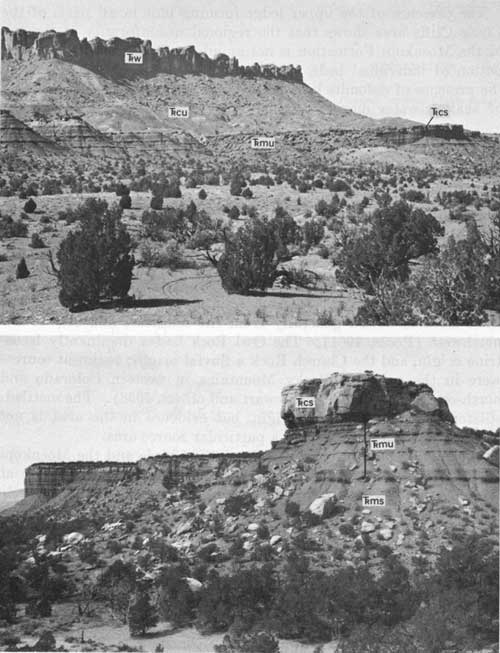
| FIGURE 5.—Upper ledge-forming unit of the Moenkopi Formation on slope below bench caped by the Shinarump Member of the Chinle Formation. TRW, Wingate Sandstone; TRCU, Chinle Formation undifferentiated; TRCS, Shinarump Member of Chinle Formation; TRMU, Moenkopi Formation, upper ledge-forming unit; TRMS, Moenkopi Formation, slope-forming unit. Upper figure: Northern Circle Cliffs area, at Moki Ruins. Lower figure: Western Circle area, near Blue Goose prospect. |
The presence of the upper ledge-forming unit in all parts of the Circle Cliffs area shows that the regional unconformity at the top of the Moenkopi Formation is not angular. The widespread distribution of individual beds, the rippling of the sandstone beds, and the presence of dolomite beds indicate that the formation is probably of shallow-water marine origin.
CHINLE FORMATION
Intertonguing fluvial mudstone, sandstone, and siltstone units of red, blue, and gray hues are combined in the Chinle Formation of the Circle Cliffs area. In ascending order the units are the mottled-siltstone unit, Shinarump Member, Monitor Butte Member, Petrified Forest Member, Owl Rock Member, and Church Rock Member. The thickness of Chinle ranges from 740 feet in the east to about 550 feet in the west. The Shinarump, Monitor Butte, and Petrified Forest Members were deposited by streams on an alluvial plain that sloped northward from a source area in and near southern Arizona; these streams flowed generally from the southeast and east to the northwest (Poole, 1961). The Owl Rock had a dominantly lacustrine origin, and the Church Rock a fluvial origin; sediment sources were in the ancestral Rocky Mountains in western Colorado and north-central New Mexico (Stewart and others, 1958). The mottled-siltstone unit is fluvial in origin, but evidence in the area is not conclusive enough to pinpoint a particular source area.
The regional unconformity between the Chinle and the Moenkopi Formations is represented mainly by the erosional unconformity at the base of the Shinarump Member of the Chinle. In the Circle Cliffs area the relief of the contact between the basal mottled-siltstone unit of the Chinle and the Moenkopi Formation is not more than 30 feet, but where this unit is absent the relief of the contact between the Shinarump and older rocks is as great as 200 feet. The mottled-siltstone unit and the Moenkopi are eroded and deeply channeled in places, and in these places the channels are filled by sandstone of the Shinarump. Thus, a significant unconformity may separate the Shinarump and the mottled-siltstone unit, although Stewart, Williams, Albee, and Raup (1959, p. 502) reached a contrary conclusion.
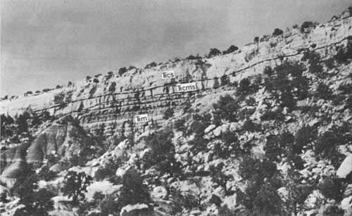
MOTTLED-SILTSTONE UNIT
The mottled-siltstone unit generally rests unconformably on the Moenkopi Formation and has been included in the Chinle Formation in this study. This unit is reddish brown and mottled white, and consists of siltstone and a few local sandstone lenses. It generally is 15-20 feet thick and locally is as much as 50 feet thick owing to channel-filling deposits underlying the more widespread upper beds. The mottled siltstone, although not thick enough to constitute a mappable unit, is widely distributed in the Circle Cliffs area, and a map showing its distribution is included in this report (fig. 6).
|
| FIGURE 6—Distribution of the mottled-siltstone unit of the Chinle Formation. Compiled by L. D. Carswell and E. S. Davidson, 1956-57. |
The basal contact of this unit is an erosion surface on which the relief averages about 2 feet and is nowhere more than 30 feet (fig. 7). In some places the surface has the form of stream channels cut in the top of the Moenkopi. In a few other places, such as at the northwest tip of Wagon Box Mesa, the mottled-siltstone unit appears to grade downward into unaltered silt of the Moenkopi Formation. This latter type of contact is not common and may indicate weathering and partial reworking of the Moenkopi at these places prior to the deposition of the mottled-siltstone unit.
|
| FIGURE 7.—Mottled-siltstone unit of the Chinle Formation (Trcms) on Wagon Box Mesa, underlain by Moenkopi Formation (Trm); overlain by Shinarump Member of the Chinle Formation (Trcs). |
The siltstone unit is very distinctive because of its mottled maroon and white coloring, ledge-forming outcrop, and vertical fracturing (fig. 7). Most commonly it consists only of well-cemented siltstone containing scattered medium- to coarse-grained fragments of quartz, but locally carbonaceous material is included. Myriad slickensided surfaces are characteristic of the unit. A 1- to 3-inch zone containing hematite-rich siltstone nodules is commonly present at the base of the uppermost, and most widespread, siltstone bed, which is about 15-20 feet thick. In a few places, notably on the largest mesa capped by Shinarump east of Wagon Box Mesa and near some of the mesas northeast of the Blue Bird prospect in Horse Canyon (pl. 1, sheet 1), 20-30 feet of mottled fine-grained sandstone fills channels and depressions below the more common widespread siltstone unit.
All color gradations and stages in the process of bleaching from maroon to grayish-white can be found. The mottling is clearly the result of bleaching by solutions that percolated downward from the top of the unit. The bleaching first followed vertical cracks down into the rock, and then extended along horizontal bedding planes to adjacent vertical cracks; as a result, balls of maroon rock were left in a matrix of white rock. If the bleaching continued, the whole rock is altered to white. Some of this bleaching extended into the underlying Moenkopi Formation, but there it is not as complete nor as widespread as in the mottled-siltstone unit.
The lithology of the mottled-siltstone unit is rather unusual; thin-section examination shows the unit to be composed almost entirely of angular grains of quartz and some kaolinite in the matrix and in microfractures; the amount of heavy minerals, mainly tourmaline, is notably greater than in either the Moenkopi or the overlying Shinarump. In addition, shreds of muscovite and scattered grains of chert are present. Feldspar is conspicuously absent. The cement is primarily silica, but some sections show considerable iron oxide and kaolinite cement. Sutured quartz grains were noted only in the hematized siltstone nodules. In an outcrop about 1 mile southeast of the Rainy Day mine (pl. 1, sheet 1), an arkose cemented by carbonate underlies the mottled-siltstone bed. The grains in the arkose are generally subrounded to angular, but many of the quartz grains have euhedral outlines. Some of the quartz grains have stylolitic boundaries where they contact other quartz grains.
The mottled-siltstone unit has been interpreted as a weathered zone of slightly reworked Moenkopi silt and some introduced coarser clastic grains (Stewart and others, 1959, p. 504). However, the angularity of the quartz grains in the Circle Cliffs area precludes such an origin because if the well-rounded grains in the Moenkopi were reduced to the angular shapes noted in the mottled-siltstone unit, they would be clay size. Most of the unit represents introduced sediment and not reworked Moenkopi, although some reworked Moenkopi surely is included in the unit, especially in places where the contact between the two appears to be gradational. One is tempted to lend more authority to the arkose outcrop southeast of the Rainy Day mine than perhaps should be done, and to conclude that the mottled unit represents a fluvially deposited arkosic unit that consists primarily of angular quartz grains, kaolinite, heavy minerals, and iron oxide (primarily hematite), and has undergone severe lateritic-type weathering.
Beds of mottled siltstone and sandstone probably correlative with the mottled-siltstone unit are exposed northeast of Moab, near the Dewey Bridge on the road from Cisco to Moab, and in the San Rafael Swell, Capitol Reef, Orange Cliffs, and Zion Park regions. Robeck (1956) applied the name Temple Mountain Member of the Chinle Formation to these beds in the San Rafael Swell, but because of the largely undeserved confusion and difference of opinion concerning the unit there and regionally (Abdel-Gawad and Kerr, 1963; Kerr and Abdel-Gawad, 1964; Johnson, 1964), particularly as to whether the unit is an alteration phenomenon ("purple white" or "pinto" effect) or a stratigraphically separable though altered unit, I prefer not to extend the name Temple Mountain Member to the Circle Cliffs area.
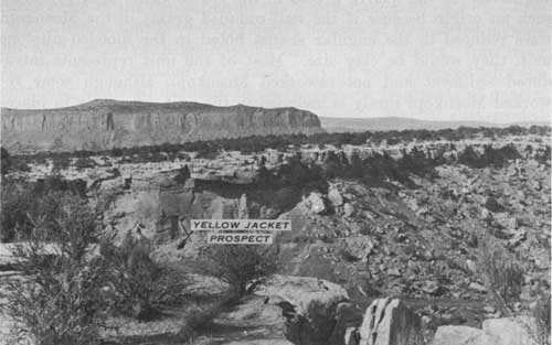
SHINARUMP MEMBER
The Shinarump Member of the Chinle Formation (Stewart, 1957) is a gray to yellowish-white sandstone that is widespread in the Circle Cliffs area. It was deposited in channels and as a blanket deposit by streams that meandered over the Moenkopi terrain (fig. 8). Lithologically, the sandstone is a feldspathic medium-grained sandstone that contains subordinate lenses of clayey silt and pebble or cobble conglomerate. Regional studies of the orientation of cross-strata (Poole, 1961) indicate that the source of the Shinarump was to the south and southeast.
|
| FIGURE 8—Shinarump Member of the Chinle Formation, a channel and blanke deposit, at Yellow Jacket prospect. |
The contact between the Shinarump and older rocks in the area is an erosional unconformity and shows little or no angularity. Some of the larger channels in the unconformity surface extend down through the mottled-siltstone unit of the Chinle Formation and the upper ledge-forming unit and most of the slope-forming unit of the underlying Moenkopi Formation. The upper contact of the Shinarump is indefinite and gradational because the Shinarump grades into, and intertongues with, the overlying Monitor Butte Member of the Chinle Formation. The stream that deposited the sand of the Shinarump flowed generally northwest (fig. 14). The largest channel, some of which is preserved in the Stud Horse Peaks, is about 190 feet deep and as much as 8,000 feet wide. Most other channels are less than 100 feet deep and 3,000 feet wide. Kleinhampl and Koteff (1960, p. 98-102) pointed out that channels can be identified by botanical methods because the pinyon: juniper ratio on benches and mesas capped with Shinarump is greater over thick deposits than over thin deposits.
The Shinarump generally can be divided into three units, which are best exposed on Wagon Box Mesa. These units, in ascending order, are medium-grained very thick bedded sandstone; interlayered thin-bedded sandstone, siltstone, and mudstone; and poorly sorted slabby thin- to thick-bedded sandstone.
The lowest unit is a relatively clean light-yellow medium-grained quartzose sandstone that forms the major part of the fill in the large channels, where it is as much as 100 feet thick. The dip of crossbedding in this unit nearly everywhere parallels closely the trend of the stream channel. The sandstone is not very carbonaceous, and conglomerate beds are sparse. The unit seems too uniform in lithology, bedding, and texture, and too noncarbonaceous, to be a favorable host for uranium minerals.
Overlying, grading into, and intertonguing with the upper part of the lowest unit is a discontinuous greenish-gray interlayed siltstone, mudstone, and sandstone unit. This unit seems to mark the top of the large channels and resembles deposits in the flood plains of modern large streams. It contains a high percentage of clay and mica and probably was deposited in quiet water or by sluggish streams.
The uppermost sandstone unit forms most of the Shinarump cap in the Circle Cliffs area and is the only Shinarump unit present on the west side of the area, where it fills myriad small channels that are about 30 feet deep and as much as half a mile wide. The unit is generally 40-60 feet thick where it constitutes the entire Shinarump, but over large channels occupied by lower units it is as much as 120 feet thick, owing mainly to thickening at the expense of the overlying Monitor Butte Member of the Chinle. It contains conglomeratic beds, is very kaolinitic, and commonly includes considerable carbonaceous charcoaly material, some of which has been silicified or partly replaced by pyrite or hematite. The general downdip direction of the crossbeds in this unit is north to northwest. In the Stud Horse Peaks channel, the crossbeds of this unit dip northeast parallel to the channel course; but on Four Mile Bench, in the southern area of Shinarump exposure, the channel courses trend westward, and crossbeds in the upper unit dip generally north. The unit is probably most favorable for uranium deposition because of the lenticularity of the beds, the common occurrence of pods and layers of clayey and carbonaceous materials, and the general high carbon and pyrite contents. The sandstone unit intertongues with the overlying Monitor Butte Member of the Chinle; it is generally thicker over the major channel courses, and it intertongues with the Monitor Butte mudstone and siltstone on the edges of the courses.
The Shinarump is feldspathic sandstone composed of quartz, feldspar, kaolin, and some flakes of muscovite and biotite. The feldspar is commonly microcline, perthite, and minor plagioclase. The quartz grains are subangular to subrounded and poorly sorted, and they commonly show overgrowths. Tourmaline, apatite, zircon, and magnetite-ilmenite occur in trace amounts. The cementing material commonly is kaolin, and the sandstone, therefore, is friable. Locally, however, the groundmass contains considerable carbonate, and the sandstone is moderately well cemented. The pebbles in the conglomeratic beds and scattered through the sandstone beds consist principally of gray quartzite, clear quartz, carbonaceous material, and fragments of gray siltstone and mudstone probably derived from the underlying Moenkopi Formation. The fragments derived from the Moenkopi are generally most common in the lowest 5 feet of the Shinarump, directly overlying the Moenkopi. In the Colorado Plateau the average ratio of quartz, quartzite, and chert pebbles in the Shinarump is 82: 16: 2 (Albee, 1957, p. 135-142). The ratio in the Circle Cliffs area is 52: 25: 23 (Albee, 1957), which shows that quartzite and chert pebbles are more abundant there than in the Colorado Plateau as a whole. The ratio of chert and quartzite to quartz pebbles increases to the south, as reported by Stewart, Williams, Albee, and Raup (1959, p. 507). This increase reflects the influence of a source area to the south, where the chert-rich Kaibab Limestone and other sedimentary rocks must have been exposed to erosion.
Fossil material from the Shinarump was collected by Frank Kleinhampl in 1955 from sec. 32, T. 32 S., R. 7 E., about 3,000 feet N. 25° W. from the Lamp Stand, a prominent butte at the north edge of the area (pl. 1, sheet 1). R. W. Brown, of the U.S. Geological Survey, identified this fragmentary plant material (written commun., 1956) as "possibly a small leaf of Sphenozamites rogersianus Fontaine." If the identification of this fragment is correct, a Triassic age can be assigned. A sample collected from a coal bed that crops out several miles west of the Blue Bird prospect contained pollen grains of Ephedra chinleana (Daugherty) R. A. Scott. Concerning this species, Scott (1960, p. 271-272) wrote: "The known stratigraphic range of this fossil Ephedra species is limited to the Upper Triassic."
The Shinarump is one of the main host rocks for uranium minerals in the Circle Cliffs area, but by 1958 no uranium ore bodies of more than 10,000 tons in size had been discovered. This, in part at least, may be due to the relatively "clean" nature of the sandstone—specifically, the relative lack of clay, clay-pellet conglomerate, and charcoaly wood fragments, most of which are present in substantial amounts at places where larger ore bodies occur in the Shinarump.
ALTERATION ASSOCIATED WITH THE SHINARUMP MEMBER
The upper few feet of the Moenkopi Formation is generally altered where the formation is overlain by the Shinarump Member of the Chinle Formation. The Moenkopi is not altered where it is overlain by mudstone of the Monitor Butte Member of the Chinle. The altered rock is light gray to dark gray where unweathered and pale yellow where weathered, which contrasts with the reddish-brown unaltered Moenkopi siltstone and with the light-yellow to gray Shinarump. The altered zone generally ranges from 1 inch to 25 feet in thickness, but normally it is about 5 feet thick. The differences in thickness are not directly related to the thickness of the Shinarump, as the altered zone occurs both under deep channels filled with Shinarump and in places where the Shinarump is only about 1 foot thick. The altered zone transects beds of the Moenkopi and is roughly parallel to the Shinarump-Moenkopi contact. The gray color, as judged from chemical analysis, is primarily due to reduction of ferric oxide in the reddish-brown rock to a ferrous form, accompanied by formation of pyrite and perhaps the addition of asphaltic material.
The gray alteration probably resulted from downward percolation of water of a reducing character from the Shinarump. It is so widespread that it is not regarded as a prospecting guide or as an indication of uranium-bearing rock.
The gray alteration associated with the Shinarump is very different from the alteration associated with the mottled-siltstone unit that overlies the Moenkopi and is overlain by the Shinarump. The mottled-siltstone unit changed from purplish red or reddish brown to white; chemically, the alteration is probably a bleaching effect and is due to complete removal of iron oxide from the red rock to produce a white rock. The purple and white altered rock is restricted to the mottled siltstone and is transected by channels filled with Shinarump. In the Blue Goose prospect area, the mottled-siltstone alteration appears to be overlapped by the gray alteration associated with the Shinarump.
Where the mottled-siltstone unit is transected by channels, the alteration peculiar to it is not found. Elsewhere, the altered zone does not follow or parallel the Shinarump-Moenkopi contact, and it may exist whether or not the Shinarump is present. In contrast, the Moenkopi is altered only where it is overlain by the Shinarump or by some other sandstone unit of the Chinle Formation.
In summary, the alteration of the mottled-siltstone unit probably predates deposition of the Shinarump and is not related to the Shinarump. The gray alteration of the Moenkopi Formation post-dates deposition of the Shinarump and is related to the Shinarump. The gray alteration is not closely correlated with uranium mineralization.
MONITOR BUTTE MEMBER
The Monitor Butte Member of the Chinle Formation (Witkind and Thaden, 1963, p. 26-28; Stewart, 1957, p. 452-453) is a greenish-gray bentonitic mudstone containing lenses of gray sand and brown conglomerate. It is equivalent to the D division of the Chinle described by Gregory (1917, p. 43). The Monitor Butte is 100-200 feet thick; the range in thickness is due mainly to the arbitrary contacts between the Monitor Butte and the underlying and overlying units—it intertongues with both the underlying Shinarump and the overlying Petrified Forest Members of the Chinle Formation. The lower contact has been placed (pl. 1) at the change from massive crossbedded white sandstone to green mudstone. In a few places the contact is placed at an upward change from thick-bedded sandstone to interlayered thin-bedded to laminated sandstone and green mudstone. The upper contact is placed at the change from green to red or at the top of the uppermost rippled sandstone beds. This contact is not shown on the geologic map but is noted in the stratigraphic sections.
The mudstone beds are dominantly greenish gray, and less commonly grayish red to reddish brown. They are lenticular and horizontally thin bedded or ripple laminated and split into shaly to blocky layers. The mudstone consists of mixtures and interbeds of bentonitic claystone, silty claystone, and clay-rich siltstone. The sandstone beds are gray to light brown and are very strikingly lenticular. The sandstone is moderately well sorted, very fine grained to fine grained, micaceous, and locally conglomeratic. Thin lenticular beds of conglomerate are common in the member. They are composed of pebbles and cobbles of light-brown limestone in a sandstone matrix, siliceous and carbonate geodes, and limonite concretions. The sandstone and conglomerate beds include minor amounts of charcoaly fragments and some silicified wood fragments.
Characteristic of the sandstone beds in this unit are their lenticularity and peculiar slump structures. The beds are almost everywhere very thin bedded and ripple laminated, which probably indicates that they were deposited in a horizontal position. Yet on the outcrop many of these lenses are shaped like great inverted troughs, dipping steeply down on either side and pitching under the green mudstones at angles of as much as 20°. No great amount of fracturing is noted where these odd structures occur; the folding is probably attributable to penecontemporaneous slumping on a jelly-like foundation of bentonitic mudstone. Sandstone lenses of this member are especially abundant and are thick near or directly over large channels occupied by the Shinarump. In such areas, a definite contact between the Shinarump and the Monitor Butte Members does not exist because of the intertonguing of the two members. This buildup of sandstone of the Monitor Butte over Shinarump stream courses probably indicates that the major stream courses established when the Shinarump was being deposited persisted during deposition of the Monitor Butte Member.
The Monitor Butte Member is generally unfossiliferous, although it has yielded a few indeterminate phytosaur teeth.
PETRIFIED FOREST MEMBER
The Petrified Forest Member, which is about 150-350 feet thick in the Circle Cliffs area, is variegated in shades of purple, red, yellow, and greenish gray and is composed of bentonitic mudstone, sandstone, and minor conglomerate.
The mudstone beds are poorly exposed, as they weather to gentle slopes covered to a depth of several inches by a frothy deposit of weathered mudstone chips. Lithologically, the mudstone is very silty to sandy clay containing scattered quartz grains, ranging in size from silt to coarse sand, and local lenses of medium-grained sandstone. The mudstone is bentonitic, firmly cemented, and calcareous and locally contains limestone nodules and rounded limestone fragments to boulder size. Locally, thin beds of gypsum are abundant.
The sandstone beds form well-exposed ledges and steep cliffs. The beds are tabular, contain ripple-laminated to medium-scale crossbeds, and split into shaly to slabby layers. The grains range from very fine to medium in size; generally they are moderately well to well sorted and weakly cemented. The sandstone is feldspathic and locally is conglomeratic, containing pebbles and cobbles of mudstone and limestone. Conglomerate beds are uncommon and thin; they consist of pebbles and cobbles of mudstone and limestone in a silty sandstone matrix.
A sandstone bed in the upper part of the member crops out fairly continuously in the northern part of the Circle Cliffs area and is probably equivalent to the informal Capitol Reef bed (Stewart, 1957, p. 457) to the north. The bed contains moderate amounts of silicified logs as much as 3 feet in diameter and 40 feet long and fragments of broken logs. These logs are brightly colored and are avidly sought by collectors for cutting and polishing. Some of the logs contain carnotite in sufficient quantities to create radioactivity anomalies noticeable in airborne exploration. A few attempts have been made—principally in Moody Canyon and in the northwestern part of the Circle Cliffs area—to collect this material for its uranium content, but the logs and fragments have not yet been found in sufficient quantity to permit economic exploitation.
OWL ROCK MEMBER
The Owl Rock Member was named and defined from exposures in Monument Valley, Ariz. (Witkind and Thaden, 1963, p. 30-32). In the Circle Cliffs area, the member is composed of resistant thin lenticular beds of green limestone interbedded with red, brown, and greenish-gray sandstone and mudstone. It ranges from about 150 to 250 feet in thickness and crops out in a steep slope under the cliff formed by the Wingate Sandstone. Characteristics that distinguish the Owl Rock from the conformably underlying Petrified Forest Member are the presence of limestone beds and a markedly smaller amount of bentonite in the mudstone and sandstone. A few conglomerate beds, containing limestone, siltstone, and chert pebbles, occur in the unit.
The sediment of the Owl Rock was deposited in a lacustrine and fluvial environment. No fossils were recovered from the rocks during this investigation.
CHURCH ROCK MEMBER
Brown sandstone crops out discontinuously in the southeastern part of the area as a 15- to 25-foot-thick ledge between the base of the Wingate Sandstone and the top of the Owl Rock Member of the Chinle. The sandstone is fine to medium grained, massive, and cross stratified on a small scale. The most conspicuous outcrops are at the south end of Deer Point and in the main and tributary canyons of East Moody Canyon. Although the Church Rock Member exposed in Monument Valley (Witkind and Thaden, 1963, p. 32-34) and in the Hite area near the Colorado River cannot be traced into the Circle Cliffs area, the unit described here is referred to as the Church Rock because of its lithology and stratigraphic position. The sediments were deposited in lakes and by streams on an alluvial plain that sloped away from a source area in the ancestral Rocky Mountains (Stewart and others, 1958).
TRIASSIC AND JURASSIC SYSTEMS
GLEN CANYON GROUP
The Glen Canyon Group consists of two prominent cliff-forming light-colored sandstone units separated by a slope-and-valley-forming reddish-brown sandstone. The lower sandstone is the Wingate Sandstone of Late Triassic age; the upper is the Navajo Sandstone of Triassic(?) and Jurassic age; the medial unit is the Kayenta Formation of Late Triassic(?) age (Lewis and others, 1961, p. 1439-1440). The Wingate and Navajo Sandstones are largely eolian in origin, and the Kayenta Formation is fluvial. Measured sections 12 through 15 are typical of the Glen Canyon Group in the Circle Cliffs area.
WINGATE SANDSTONE
The Wingate Sandstone is a prominent massive cliff former that bounds the interior of the Circle Cliffs area. The name "Circle Cliffs" probably originated from the oval-shaped bounding rim of these cliffs. The sandstone generally ranges in thickness from 230 feet in the east to 350 feet in the west and northwest. It is distinctive because of its cliff exposure, very thick bedding, and large-scale crossbeds.
The Wingate erodes to towering cliffs that overhang in canyons and stand as nearly vertical irregular walls in more exposed places. The tops of the cliffs are rounded, and the faces are rugged, irregular, and interrupted by vertical joints. Exposed horizontal surfaces weather to rounded shapes. Weathered surfaces of the sandstone typically contain rounded "bird-hole" solution cavities; and where weathering has been intense, the holes are bounded by a delicate lacy pattern of thin sandstone walls.
The Wingate Sandstone is light brownish orange and is very well sorted, very fine to fine grained, and quartzose. Some medium to coarse grains of quartz are scattered throughout the unit, and a 2- to 6-foot-thick bed of poorly sorted very fine grained to medium-grained sandstone is at the base. The Wingate is moderately friable to moderately well cemented with calcium carbonate. The beds are planar and trough cross-stratified in sets that are 40-60 feet thick and 100 feet long. The crossbeds dip northeast to southeast. Horizontal parting planes separate the crossbed sets in the unit. In the uppermost 100 feet, discontinuous thin beds of red siltstone and gray carbonate rock occur locally along the parting planes. These beds probably were deposited in small lakes.
The Wingate is generally conformable, but locally unconformable, with the underlying Chinle and the overlying Kayenta Formations. The contact with the Chinle is sharp and well defined with little or no relief, except in the Long Canyon area in the northwestern part of the Circle Cliffs area where 15-25 feet of poorly sorted fluvial sandstone beds forms the base of the Wingate and fills erosional pockets in the top of the Chinle. The upper contact is an undulatory surface with a maximum relief of about 40 feet. It is erosional and unconformable but probably does not represent a significant time break. In the southeastern part of the area, the Wingate and Kayenta appear to intertongue in a zone 40 to 50 feet thick.
The normally light-brownish-orange Wingate has been altered to white throughout an irregular area in the northwestern part of the Circle Cliffs area. The zone of altered rock extends from the base almost to the top of the formation. The boundary between the white rock and the orange rock is fairly regular; in places it follows parting planes between crossbed sets, and elsewhere it cuts across the bedding and parting planes. Thin-section studies, by G. A. Miller, and chemical analyses indicate that the color difference is due primarily to loss of ferric iron in the white rock. Black opaque minerals have been altered to a material resembling leucoxene (white under reflected light), and all interstitial limonite has been removed. Otherwise the white and orange rocks are identical. Light brownish orange is the original color and is characteristic of the Wingate in unweathered outcrops and in drill-hole samples. The white rock has probably resulted from leaching by ground water, derived from precipitation and from runoff in the Boulder Mountain area, before canyon cutting exposed and drained the sandstone.
The Wingate of the Circle Cliffs area is probably equivalent to the Lukachukai Member of the Wingate in northeastern Arizona and northwestern New Mexico. It is primarily eolian in origin; west and northwest winds created very thick dunal deposits.
KAYENTA FORMATION
The Kayenta Formation is a ledge-forming reddish-brown sandstone and is about 320-400 feet thick in the Circle Cliffs area. It caps most of the Wingate cliffs and forms extensive benches and slopes in the western and southern parts of the area. It forms the floor of Muley Twist Canyon, which is walled by the Navajo and Wingate Sandstones.
The Kayenta is composed of thin to very thin bedded sandstone and minor siltstone. It is dominantly reddish brown to dark purplish red, but some beds are grayish white. The beds are lenticular, split into flaggy to massive layers, and are trough cross-stratified on a small to medium scale. Some beds, particularly in one 20- to 40-foot-thick unit in the uppermost one-third of the formation and other thinner beds in the upper part of the formation, display large-scale trough cross-stratification commonly associated with sandstone of eolian origin. The sandstone and siltstone are micaceous and feldspathic, and many of the beds contain abundant mud chips. Calcareous sandstone beds are moderately common, and there are a few beds of light-yellow limestone. The sandstone is largely medium to coarse grained and thick to very thick bedded in the eastern part of the Circle Cliffs area and fine to very fine grained and thin to very thin bedded in the western part. More siltstone occurs in the western part of the area than in the eastern part.
The Kayenta Formation and the overlying Navajo Sandstone are conformable and do not appear to intertongue in the area mapped, but they are difficult to distinguish where crossbedded rock forms the top of the Kayenta and where the lower part of the Navajo contains many carbonate beds. The uppermost bed of the Kayenta commonly is a grayish-red-purple poorly sorted siltstone or mudstone that grades laterally into crossbedded and horizontally stratified siltstone, sandstone, and calcareous sandstone beds. Locally, the unit is mottled green and brown; the green color extends downward along vertical fractures and is assumed to be an alteration phenomenon associated either with weathering or with percolation of ground water from the overlying Navajo. Except for its weak cementation, this bed is similar to the mottled-siltstone unit of the Chinle Formation.
Some poorly preserved pelecypods in unidentifiable condition were collected from a calcareous sandstone in this formation, and three-toed dinosaur (?) tracks were noted at a few localities in the northern part of the area. The bedding structures indicate a dominantly continental and fluvial origin for this formation. From studies of cross-stratification, Poole (1961) concluded that the source of Kayenta was to the east; the grain-size distribution of the sandstone beds in the Circle Cliffs area supports this interpretation.
NAVAJO SANDSTONE
The Navajo Sandstone is a cliff-forming white sandstone that generally ranges in thickness from 950 feet in the northern part of the area to 1,400 feet in the southern part. It is composed dominantly of well-sorted very fine to fine subrounded frosted quartz grains and is crossbedded on a large scale. It ranges from friable to well cemented, the degree of cementation depending primarily on the amount of carbonate in the rock. A few thin carbonate beds occur chiefly in the lower 400-500 feet of the formation in the southern part of the area. Some of these carbonate beds, which are generally limestone or sandy limestone and not more than 10 feet thick, may be traced 10-15 miles. A few lenses of red siltstone are interbedded in the Navajo Sandstone in the southern part of the area.
The crossbeds in the Navajo are in sets as much as 70 feet thick and 150 feet long. The tops and bottoms of the sets are principally plane surfaces, but some show trough-type truncations. The very large scale cross-stratification, the fine grain size, and the excellent size sorting of the grains in the Navajo are typical of windblown dune deposits. The wind that formed the sand dunes blew from the west and northwest, as indicated by the orientation of the cross strata.
Many of the tributary streams that cut across the bedding strike along the Waterpocket fold have potholes along their courses in the upper part of the Navajo, generally within a few hundred feet of the Carmel contact. These potholes are called waterpockets because in rainy seasons they are a source of drinking water. Some of these tributaries have permanent flows sufficient to support a lush semi-tropical vegetation.
Nodules of black manganese wad have been found as float lying on and near the Navajo, especially the uppermost beds, in the eastern and southeastern parts of the area. None of this material has been seen in outcrop, but possibly a few small bedded or vein deposits of manganese occur in the Navajo Sandstone or Carmel Formation. A manganese deposit occurs near the Navajo-Carmel contact in Harris Wash, about 1 mile south of the map boundary.
The Navajo is chiefly eolian in origin, but some short-lived lakes or standing bodies of water are indicated by the thin interbedded carbonate and red siltstone beds.
JURASSIC SYSTEM
SAN RAFAEL GROUP
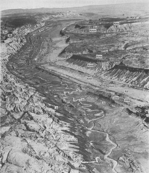
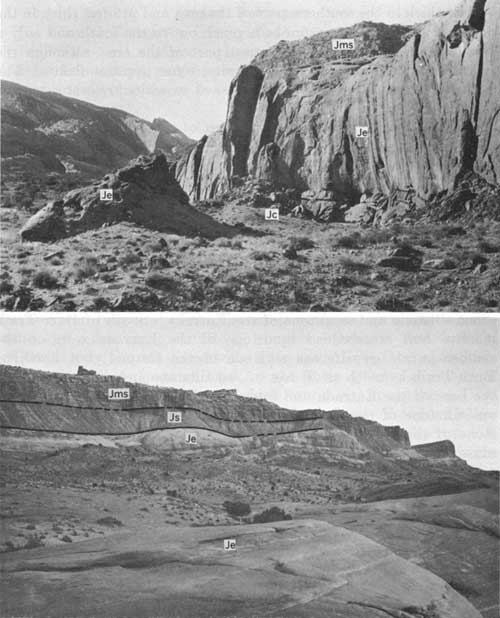
Members of the San Rafael Group in the Circle Cliffs area are, in ascending order, the Carmel Formation, the Entrada Sandstone, and the Summerville Formation. The most complete exposure of rocks of the group is in Hall Creek Valley (fig. 9). The position of the Curtis (?) Formation is marked by a thin discontinuous calcareous bed. The San Rafael Group is 1,100-1,300 feet thick and is largely continental or near-shore marine in origin. Wright and Dickey (1958) stated that the source areas of the Carmel and the Entrada were to the east, at the east and south edges of the Colorado Plateau. The depositional centers were in an ancient geosyncline in the eastern Great Basin. Cross strata in the Curtis dip northeast from a source area in the ancient geosyncline, indicating that the geosyncline was uplifted prior to the deposition of the Curtis (Wright and Dickey, 1958).
|
| FIGURE 9—Hall Creek Valley near Burr Trail. Wingate Sandstone (Trw); Kayenta Formation (Trk); Navajo Sandstone (JTrn); Carmel Formation (Jc); Entrada Sandstone (Jo); Summerville Formation (Js); Salt Wash Sandstone Member (Jms) and Brushy Basin Shale Member (Jmb) of the Morrison Formation; Dakota Sandstone (Kd); Tununk Shale Member (Kmt), Ferron Sandstone Member (Kmf), Blue Gate Shale Member (Kmb), Emery Sandstone Member (Kme), and Masuk Member (Kmm) of the Mancos Shale; and Mesaverde Formation (Kmv). |
CARMEL FORMATION
The Carmel Formation is bright-red slabby and ledgy interbedded sandstone and mudstone. It ranges in thickness from about 200 feet in the southern part of the valley to 300 feet in the northern part and is divided into a lower, limy unit and an upper, gypsiferous unit.
The contact between the Carmel Formation and the Navajo Sandstone is generally sharp and smooth. In the northern part of Hall Creek Valley the contact is placed at the base of a 5- to 10-foot-thick massive brown sandstone. The sandstone is not very easily identified south of Burr Trail, and southward from there the contact is placed at the break from large-scale crossbeds of the Navajo to the horizontally stratified or small-scale-crossbedded sandstone of the Carmel. In contrast to the normal bright red of the Carmel siltstone, the lower 10-25 feet of the Carmel is commonly the same color as the Navajo, so that a color change does not everywhere mark the contact. The sandstone beds assigned to the Carmel were probably reworked from the Navajo.
The lower, limy unit of the Carmel is composed of bright-red siltstone and subordinate sandstone, conglomerate, and thin beds of yellowish-gray to pink limestone. This unit of the Carmel is probably equivalent, in part at least, to the Twin Creek Limestone of Middle and Late Jurassic age, which crops out in northern Utah (Imlay, 1953, p. 54-59), and the Middle Jurassic Judd Hollow Tongue of the Carmel (Phoenix, 1963, p. 32-33), which crops out in the Lees Ferry area. (See also Wright and Dickey, 1963.) The limy unit is probably of marine and near-shore marine origin. It is about 90 feet thick in the northern part of Hall Creek Valley and 135 feet thick in the southern part. This unit, because of the limestone beds, is more resistant to erosion than either the underlying Navajo Sandstone or the overlying gypsiferous unit. The result in Hall Creek Valley—and, in fact, northward from the Colorado River along the Circle Cliffs anticline, Capitol Reef, and the San Rafael Swell—is a striking series of steeply dipping red flatirons of Carmel shielding white mounds of Navajo Sandstone to the west (fig. 9).
Marine fossils, mainly pelecypods, are found in the limestone beds to the north in the Capitol Reef area and along the San Rafael Swell. These fossils are Middle and earliest. Late Jurassic in age (Smith and others, 1963).
The upper, gypsiferous unit of the Carmel is soft earthy red siltstone containing intercalated very thin gypsum beds and a few sandstone lenses, especially near the top of the unit. The bedding in this unit is undulatory and contorted, especially in the several small bends on the flank of the Circle Cliffs anticline. The unit is about 70 feet thick in the southern part of the area and 215 feet thick in the northern part. The gypsum beds pinch out to the south and only a few beds occur in the southernmost part of the area, although the reddish-purple siltstone there contains some gypsum flakes. The gypsiferous unit probably was deposited in a shallow-water marine environment.
South of Burr Trail the upper 50 feet of the gypsiferous unit contains numerous isolated lenses of buff sandstone with medium- to large-scale crossbeds. The sandstone is similar in all respects to that of the overlying Entrada Sandstone. The bedding of some of these lenses is contorted, probably owing to slumpage and flowage on the unconsolidated silt and gypsiferous base. The lenses resemble sand dunes, and I regard them as sand-dune tongues of the Entrada. The lenses are overlain by reddish-purple gypsiferous siltstone every where in the mapped area and, therefore, were mapped as Carmel (fig. 10).
|
| FIGURE 10—Upper and lower contacts of the Entrada Sandstone in Hall Creek Valley. A, Carmel-Entrada contact, showing Carmel Formation (Jc), a sandstone tongue (eolian(?) origin) of Entrada Sandstone (Jo), and Salt Wash Sandstone Member of the Morrison Formation (Jms). B, Entrada-Summerville contact, showing lower sandy, medial silty, and upper sandy members of the Entrada Sandstone (Je), Summerville Formation (Js), and Salt Wash Sandstone Member of the Morrison Formation (Jms). |
The contact of the Carmel and Entrada is placed at the break between the gypsiferous siltstone of the Carmel and the nongypsiferous siltstone and sandstone of the Entrada. South of Burr Trail, massive buff crossbedded sandstone of the Entrada rests on the reddish-purple gypsiferous siltstone of the Carmel; but north of Burr Trail, as much as 30 feet of red siltstone and sandstone forms the base of the Entrada and separates the reddish-purple gypsiferous siltstone of the Carmel from the overlying massive buff sandstone of the Entrada. This contact was chosen because the lower massive crossbedded sandstone of the Entrada rises in the section and pinches out to the north (J. C. Wright, written commun., 1957).
ENTRADA SANDSTONE
The Entrada Sandstone of the Circle Cliffs area, exposed only in Hall Creek Valley, is divided into an upper massive "slick-rim" sandstone, a medial earthy hoodoo-weathering siltstone, and a lower "slick-rim" sandstone (fig. 10B). These units are identical with the upper sandy, medial silty, and lower sandy members, respectively (Harshbarger and others, 1957, p. 35-38), in the Navajo country, which names will be used in this report. The total thickness of the Entrada ranges from 700 to almost 900 feet in Hall Creek Valley.
Lower sandy member.—The lower sandy member of the Entrada Sandstone is massive very fine grained to fine-grained brown sandstone containing moderate amounts of medium to coarse frosted grains of pink and gray quartz. The member also contains a few interbeds of red siltstone and shaly siltstone, especially in the northern part of Hall Creek Valley. In many places this member is covered with recent deposits of windblown sand largely derived from the underlying bedrock. The bedding is varied. In some places the unit is horizontally stratified in 2-inch- to 6-foot-thick layers; in other places medium- to large-scale high-angle crossbeds are common, and the beds of cross-strata sets are separated by horizontal parting planes as much as 20 feet apart. The lower sandy member is generally about 250 feet thick in the northern part of Hall Creek Valley and thickens to the southeast, where it is 363 feet thick (section 17).
Pipelike slump structures are common at the contact between the lower sandy member and the Carmel Formation. These structures are roughly circular in plan view, 50-150 feet in diameter, and extend 30-60 feet downward into the Carmel. The central parts of the structures are filled with structureless sandstone similar to the overlying sandstone. The beds of the Carmel are brecciated at the contact of the pipe structure, and in one exposure the bedding of the Carmel siltstone at the edges of the cylinder dips away from the structure. The beds in the overlying Entrada Sandstone are slumped over the structure, but this slumpage dies out upward within about 60 feet. This strange type of structure is ascribed to ground water forcing its way up through the soft unconsolidated tidal-flat siltstone of the Carmel (Hawley and Hart, 1934; Gabelman, 1955; Phoenix, 1958) to form a cylindrical opening or depression into which the overlying sand sifted. The fine sand is winnowed out by the upward flow of water, and well-sorted coarse sand remained in the pipe. In present-day circumstances, chiefly along rivers and beaches and near springs, the same upward movement of ground water under artesian pressure through sand results in "quicksand." Here, the grains are well sorted and partially suspended by the upward flow of water, so that a heavy object may easily sink into the poorly supported sand structure. In other places the sandstone of the Entrada seems to have settled down into the Carmel; this process produced a rolling contact similar to an erosional contact.
To the north, the lower unit is inseparable from the overlying medial unit because the "slick-rim" type of resistant sandstone which characterizes the lower unit rises slightly in the section and grades into red siltstone similar to that of the medial unit (J. C. Wright, written commun., 1957)
Medial silty member.—The medial silty member of the Entrada Sandstone is reddish-brown siltstone, very fine grained sandstone, and mudstone. The rocks are friable and earthy, weather easily, and generally are incompletely exposed. Both contacts of the member are gradational in Hall Creek Valley. Where exposed, the medial silty member is dominantly horizontally stratified in beds 1 inch to 8 feet thick. A few resistant sandstone beds tend to emphasize the bedding. The member is 320-360 feet thick.
Upper sandy member.—The upper sandy member of the Entrada Sandstone grades laterally from a thin-bedded white and brown sandstone to a massive "slick-rim" cliff-forming brown sandstone. It is 170-250 feet thick. The sand grains are composed of quartz and are dominantly very fine to fine, but very coarse grains are common in a few beds. In a distance of 1,000 feet along the strike, the member changes from a horizontally stratified white and brown or white slope-forming sandstone to a large-scale trough-cross-stratified cliff-forming sandstone. The "slick-rim" cliff-forming sandstone appears to be slightly more widespread than the horizontally stratified sandstone. Like the lower sandy member, the cliff-forming sandstone is divided by numerous parallel parting planes and is very thick bedded. The beds are commonly contorted, probably because of slumpage shortly after their deposition.
CURTIS(?) FORMATION
The Curtis(?) Formation is not a mappable unit in the Circle Cliffs area and where present was mapped with the overlying Summerville Formation (pl. 1). It is a discontinuous 5-foot-thick white calcareous sandstone or sandy limestone containing fairly abundant specks of glauconite and red and black chert pebbles. The sandstone is probably correlative with the Curtis Formation, which crops out to the north in the Capitol Reef and San Rafael Swell areas; but because of the discontinuity of the formation, the correlation is questionable. The Curtis (?) rests unconformably on the underlying Entrada; the unconformity is most obvious where the upper sandy member of the Entrada is a "slick-rim" sandstone that displays slumpage structures (fig. 10B).
SUMMERVILLE FORMATION
The Summerville Formation, a poorly exposed sequence of reddish-brown to light-gray sandstone and siltstone beds, is 50-190 feet thick in the Circle Cliffs area. The formation crops out on a smooth slope under the hogback-forming cap of the Salt Wash Sandstone Member of the Morrison Formation, and on this slope the sandstone beds stand out in thin resistant ledges or "ribs." The unit consists of thin beds of brown to white very fine grained to fine-grained sandstone separated by soft earthy red to brown siltstone and mudstone beds. The upper part of the Summerville contains lenticular beds of white sandstone, which are cross-stratified on a small scale. Disseminated flakes and fracture fillings of gypsum are common in the siltstone and mudstone, and a few thin limestone beds are intercalated at the base and top of the formation. The sandstone beds in the upper part of the section measured near Bitter Creek Divide (section 16) contain rounded fragments of red, yellow, light-green, and black chert.
The Summerville is structurally concordant with the overlying Morrison Formation, and in Hall Creek Valley the contact between the two formations lacks the angular unconformity and erosional channels that are so common in the San Rafael Swell area to the north.
MORRISON FORMATION
The Morrison Formation (Cross, 1894, p. 2; Emmons and others, 1896, p. 60-62) is exposed in the eastern part of the Circle Cliffs area, where it is about 470-740 feet thick. Details of origin, lithology, and regional variation of this formation were discussed by Craig and others (1955).
The formation consists of lenticular gray sandstone, conglomerate, and variegated mudstone strata of fluvial origin. The Morrison in the Circle Cliffs area is separable lithologically into two members. The lower, Salt Wash Sandstone Member consists of sandstone and minor mudstone and conglomerate; the upper, Brushy Basin Shale Member consists of mudstone containing a few thin interbeds of sandstone and conglomerate.
SALT WASH SANDSTONE MEMBER
The Salt Wash Sandstone Member (Lupton, 1914, p. 127; Gilluly and Reeside, 1928, p. 82) is a lenticularly stratified gray to light-red sandstone that includes minor amounts of interbedded conglomerate and reddish- to greenish-gray mudstone. It is a cliff former, and is usually seen in steep-walled canyons, hogbacks, and benches. The Salt Wash is about 300-450 feet thick in the Circle Cliffs area.
A prominent and nearly continuous 4- to 5-foot-thick bed of calcareous sandstone, which marks the base of the Salt Wash, is well exposed from the area of "The Post" (Hall Creek Valley near the south end of Swap Mesa) north and can be located with some difficulty south of "The Post." The sandstone is distinctive because it includes abundant large chalcedony fragments as much as 1 foot in diameter that are various shades of red, yellow, blue green, and black; the fragments are prized as a source of polished rock specimens.
The lenticular sandstone lenses of the Salt Wash are made up of sets of medium-scale cross-strata. South of "The Post," the sandstone lenses are as much as 40 feet thick, can be traced for several miles, and contain few mudstone interbeds; thus, they give the Salt Wash a massive appearance. North of "The Post," mudstone interbeds are common and the sandstone is considerably more lenticular, as the lenses are only 2-40 feet thick and can be traced for only a few hundred feet.
The sandstone is quartzose and contains small amounts of feldspar and gray, red, and green chert. Fragments of carbonaceous wood are common in the unit, and some of these fragments have been replaced by chalcedony, producing red, blue, and yellow rock fragments. The rock is moderately well cemented to friable. The cement is primarily carbonate, but some silica occurs as cement and as overgrowths on grains. Thin conglomerate beds are intercalated with the sandstone, but, in general, the larger grains and pebbles are scattered through the sandstone or are strung out in thin layers along bedding planes. The coarse material consists of quartzite, wood fragments, gray and pink chert, clear quartz, and minor red, black, and green chert. The maximum pebble size is about 2 inches, and the average size is about three-quarters of an inch. Limestone pebbles containing impressions and molds of crinoid stems and bryozoan fragments occur locally. Fossils in chert pebbles collected from the Salt Wash were reported (Craig and others, 1955, p. 150) to be late Paleozoic in age and, therefore, the pebbles probably were derived from exposures of the Kaibab Limestone to the south. Stratigraphic studies by Craig and others (1955, p. 145) indicate that the Salt Wash was deposited by streams that flowed north to northeast across the Circle Cliffs area.
The mudstone beds of the Salt Wash are generally red in the Circle Cliffs area, but they are more commonly green or greenish gray in the lower part of the member and near uranium-bearing areas. The mudstone, composed of clay- to silt-sized particles, is generally sandy; it contains quartz grains as large as medium sand.
Several uranium prospects are located in the lower part of the Salt Wash, but none of these appear to be of much economic value. Most of the uraniferous material is accompanied by selenium, and this element encourages the abundant growth of loco weed (Astragalus pattersoni) at the base of the Salt Wash cliffs. The prospects are in a transition zone where massive and nearly tabular-bedded sandstone grades to very lenticular intercalated sandstone and mudstone.
BRUSHY BASIN SHALE MEMBER
The Brushy Basin Shale Member (Gregory, 1938, p. 59) is composed of mudstone, claystone, and minor sandstone and conglomerate that are variegated greenish to yellowish gray and reddish purple. The lower part of the member is banded purple, red, and some yellow, and the upper part is chiefly gray. The entire unit is slope forming and weathers to a colorful badland topography of gently rounded knolls and hills. The member contains bentonitic clay, and weathered slopes have a "popcorn" or frothy surface owing to the swelling of the clay. The maximum thickness is about 300 feet, and the minimum is less than 100 feet. Some of the upper part of the Brushy Basin as mapped may be equivalent to the Cedar Mountain Formation (Stokes, 1944, p. 965) of Early Cretaceous age, which has been traced southward to Notom Junction, several tens of miles north of the Circle Cliffs area, but the present study has yielded no evidence to support this correlation.
The mudstone beds are thinly laminated to structureless, and their components generally range in size from clay to silt; varied small amounts of coarser fragments are strung out along bedding planes. The sandstone is white to gray and fine to medium grained and has a green clay matrix. It generally contains abundant red and green chert pebbles. The conglomerate is composed of red and green chert pebbles in a matrix of very coarse grained sand to granule-sized gravel. The mudstone, sandstone, and conglomerate of the Brushy Basin are characterized by red and green chert pebbles and greenish-gray and purplish colors, whereas the Salt Wash is characterized by gray to clear pebbles and red and light-gray colors.
The contact with the Salt Wash is placed at the base of the lowest sandstone or conglomerate containing abundant red and green chert pebbles. The conglomerate is nearly continuous in outcrop from the northern part of the area to the "Red Slide," near the south end of Big Thomson Mesa; but south and southeast of "Red Slide" the conglomerate is less continuous, and the contact is placed arbitrarily at the base of the lowest red and green chert conglomerate or at the top of the uppermost massive white sandstone. Consequently, the contact in the southern part of the area is shown on the map (pl. 1) as gradational or intertonguing. Locally in the northern part of the area, the entire lower purplish part of the Brushy Basin is absent where the Salt Wash has thickened abruptly, but the conglomerate rises in the section and can be traced through without a break.
The Brushy Basin was deposited in a fluvial and lacustrine environment. Much of the bentonitic clay probably was derived from volcanic-ash falls (Craig and others, 1955, p. 156-157).
CRETACEOUS SYSTEM
The Cretaceous formations cropping out in the Circle Cliffs area were mapped and described by Hunt, Averitt, and Miller (1953, p. 77-86), and only a limited amount of time was spent examining these formations during the present study. The formations were deposited near the west edge of a geosyncline whose axis is in the High Plains (Hunt and others, 1953, p. 77). Most of the discussion by Fisher, Erdmann, and Reeside (1960) of the stratigraphy, origin, age, and correlation of Cretaceous formations in the Book Cliffs, 100 miles to the north, is applicable to the formations of the Circle Cliffs area.
The rocks are typical of marine and coastal-plain deposits and reflect successive advances and retreats of the shoreline. Most of the sandstone units, such as the Dakota Sandstone and the various sandstone members of the Mancos Shale, were deposited in a near-shore fluvial or marine environment. The coaly sediment was deposited in swamps, the crossbedded clean sandstone along stream courses, and the ripple-laminated and horizontally stratified yellow fine-grained sediment in shallow waters near the shore. The mudstone, siltstone, and shale beds, especially of the Mancos, were deposited in deeper water offshore.
The Dakota Sandstone, the lowest of the Cretaceous formations, lies on the eroded surface of the Morrison Formation in the Circle Cliffs area.
DAKOTA SANDSTONE
The Dakota Sandstone (fig. 11), as mapped in this investigation (pl. 1), is 100-150 feet thick and is divisible into two units, which are gradational and intertongue at their contact. Probably only the lower unit is correlative with the Dakota Sandstone as mapped south of the Circle Cliffs area. The lower unit typically is a crossbedded white sandstone, and the upper is an interbedded sequence of yellow brown mudstone and fossiliferous sandstone. The lower unit was deposited in a fluvial stream and swamp environment, and the upper unit in a marine or near-shore environment. Stokes (1950) and Katich (1954, p. 45) suggested that much of the Dakota Sandstone was deposited during pedimentation, but only part of the lower unit possibly fits into this class of deposit in the Circle Cliffs area.
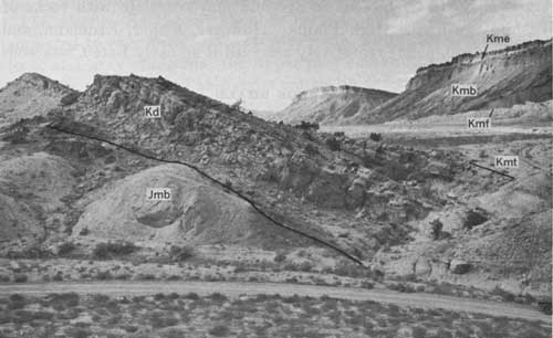
|
| FIGURE 11—Dakota Sandstone at "The Post," Hall Creek Valley. Brushy Basin Shale Member of the Morrison Formation (Jmb); Dakota Sandstone (Kd); and Tununk Shale Member (Kmt), Ferron Sandstone Member (Kmf), Blue Gate Shale Member (Kmb), and Emery Sandstone Member (Kme) of the Mancos Shale. |
The lower unit is 2-30 feet thick. It consists of thinly to thickly crossbedded poorly sorted white quartzose sandstone and local conglomerate beds consisting of abundant black, red, and green chert pebbles in a coarse sandstone matrix. Black and gray coaly and carbonaceous mudstone interbeds are very common and locally are diagnostic of the unit; some beds are stained with an asphaltic or petroliferous residue. No fossils have been recovered from this unit in the Circle Cliffs area.
Rocks of the upper unit resemble those of the overlying Mancos Shale. They consist dominantly of yellow-brown and less commonly of gray fossiliferous sandstone and mudstone and minor amounts of black, coaly shaly-splitting mudstone. The sandstone is yellow brown to brownish white, well sorted, fine to medium grained, and ripple laminated. The mudstone is yellow brown to dark gray, horizontally stratified, and thin bedded to laminated. The upper most sandstone beds in the upper unit contain abundant Ostrea and Exogyra shells.
The contact between the Dakota Sandstone and the Morrison Formation is easily located in most of the northern part of the Circle Cliffs area, where a basal sandstone or conglomerate of the Dakota is present and the contact is markedly erosional. In the southern part of the area, however, gray mudstone of the Dakota commonly rests on gray mudstone of the Brushy Basin Shale Member of the Morrison Formation, and it is very difficult to accurately locate the contact. In general, distinction is based on the fact that the Brushy Basin mudstone is bentonitic and the Dakota mudstone is coaly and nonbentonitic. The contact is erosional and is not angular in the Circle Cliffs area.
The upper contact is very sharp although gradational; gray sandy mudstone and claystone of the Tununk Shale Member of the Mancos Shale rest on the uppermost sandstone of the Dakota. The sandstone forms a prominent hogback, and the break in the dip slope of the hogback coincides very nearly with the contact.
The Dakota is considered to be Early (?) and Late Cretaceous in age. According to Katich (1954, p. 43, 45-46), the Dakota of the region is Early Cretaceous in age and may correlate with rocks of Washita age in the High Plains. However, Fisher, Erdmann, and Reeside (1960, p. 25) tentatively assigned it an early Late Cretaceous age.
MANCOS SHALE
The Mancos Shale in the Circle Cliffs area is divided into five members that total about 3,450 feet in thickness. All the contacts, both between the members and at the top and bottom of the formation, are gradational and arbitrary. In ascending order, the members are the Tununk Shale, Ferron Sandstone, Blue Gate Shale, Emery Sandstone, and Masuk (fig. 9). Deposits of heavy minerals, marking ancient shorelines, have been discovered in sandstone beds of the Mancos in the Henry Mountains region and in the Upper Cretaceous Straight Cliffs Formation of the Kaiparowits Plateau, but none were noted in the mapped area. Salt crusts are very common on outcrops of the Mancos, especially near springs and seeps and along ephemeral-stream courses. Details of the stratigraphy and origin of the Mancos and associated formations in the Circle Cliffs and adjoining regions were discussed by Spieker and Reeside (1925; 1926), Hunt, Averitt, and Miller (1953, p. 79-86), and Katich (1954). No stratigraphic sections of the Mancos were measured during the present study, but several sections from nearby areas were recorded by Hunt, Averitt, and Miller (1953, p. 79-86).
TUNUNK SHALE MEMBER
The Tununk Shale Member is dark gray mudstone or slightly fissile shale and includes a few thin bentonite interbeds and, near the top and bottom, some sandstone beds. The Tununk is gradational with the uppermost sandstone bed of the Dakota Sandstone and intertongues and intergrades with the overlying Ferron Sandstone Member. It is 550-650 feet thick; the range in thickness is largely because of intertonguing with the Ferron Sandstone Member. The Tununk weathers easily and is generally covered by a few inches to several feet of soil or alluvium. Planar erosional surfaces tend to form at the base of the escarpment formed by the overlying Ferron Sandstone Member, especially south of Swap Mesa. Beds at the base of the unit contain abundant fossil oysters (Gryphae newberryi).
The Tununk is considered to be Late Cretaceous in age. However, according to Katich (1954, p. 43, 46) the Tununk is "Albian to lower Carlile in age"; that is, the lower part is probably Early Cretaceous and the upper part Late Cretaceous in age.
FERRON SANDSTONE MEMBER
The Ferron Sandstone Member consists of fine-grained ripple-laminated to even-bedded brown sandstone, white crossbedded sandstone, and gray mudstone; the upper part contains considerable coal and coaly mudstone. The Ferron ranges in thickness from 200 feet in the northern part of the mapped area to 350 feet in the area of "The Post." and the Burr Trail. Its contact with the Tununk Shale Member is gradational and intertonguing. One tongue of sandstone is mapped separately from the Burr Trail area north to the mouth of Divide Canyon, where it merges into the sandy mudstone of the Tununk.
The contact between the Ferron and the overlying Blue Gate Shale Member is generally sharp, and the marine bluish-gray mudstone of the Blue Gate rests directly on the lenticular sandstone or coaly beds of the upper part of the Ferron. The Ferron is early and middle Carlile in age (Katich, 1954, p. 48).
BLUE GATE SHALE MEMBER
The Blue Gate Shale Member ranges in thickness from about 1,200 feet in the southern part of the mapped area to 1,500 feet in the northern part. It is composed of dark-bluish-gray finely laminated mudstone with a few beds of bentonite, shaly sandstone, and sandy limestone. The upper part of the Blue Gate contains more calcareous sandstone beds than the member as a whole and grades into the overlying Emery Sandstone Member. The contact between the two was arbitrarily chosen.
East and south of Swap Mesa, at locally conglomeratic sandstone bed at the base of the Blue Gate rests on the eroded surface of the Ferron Sandstone Member and grades into the overlying Blue Gate Shale Member. The bed thickens to 30 feet from a few feet within short distances, and most of the change occurs at the top of the unit. Hunt, Averitt, and Miller suggested (1953, p. 83) that the sandstone is a transgressive beach deposit.
Spieker and Reeside (1925, p. 438) stated that much, if not all, of the Blue Gate of the Wasatch Plateau is Niobrara in age. Cephalopods collected from the upper 600 feet of the Blue Gate in the Henry Mountains are early Montana in age (Spieker and Reeside, 1926, p. 438; Reeside, 1927, p. 1, 5). The Blue Gate, of the Henry Mountains and Circle Cliffs areas at least, is probably Niobrara and early Montana in age.
EMERY SANDSTONE MEMBER
The Emery Sandstone Member, as mapped in this study, is about 120-300 feet thick. Part of this range is due to the difficulty in choosing the same lower contact in all areas, but a greater part is due to uncertainty in the upper contact. In the southern part of the Emery outcrop area, a sandstone considered by Hunt, Averitt, and Miller (1953) to be the basal unit of the overlying Masuk Member was mapped with the Emery in the present investigation. This sandstone interfingers with silt and shale of the Masuk about 3 miles south of Bitter Creek Divide, and from there to the north edge of the mapped area the contact has been dropped stratigraphically to the horizon that was used by Hunt, Averitt, and Miller (1953).
The Emery Sandstone Member consists of a massive sandstone overlain by coaly and carbonaceous shale and an upper lenticular unit of white sandstone that contains a few gray shale interbeds. The massive sandstone is light yellow to light brown, fine grained, even bedded to ripple laminated, and cliff forming. The coaly shale beds are lenticular and interbedded with white crossbeded fine- to medium-grained sandstone. The upper sandstone is white to light gray, crossbedded, and lenticular; it closely resembles the fluvial Shinarump Member of the Chinle Formation and is regarded as being of fluvial continental but near-shore origin. Because the upper sandstone bed is more closely allied to the Emery in lithology and environment of origin, it was mapped as part of the Emery Sandstone Member instead of a part of the marine Masuk Member. Fossils collected from the Emery are early Montana in age (Katich, 1954, p. 48).
MASUK MEMBER
The Masuk Member is 700-900 feet thick and consists of silty gray mudstone and light-yellow sandstone. The number and thickness of the sandstone beds increase upward; thus the contact between the Masuk and the overlying Mesaverde Formation is transitional. In the mapped area, the Masuk forms a steep smooth slope protected at the top by the cliff-forming Mesaverde Formation.
The composition of the lowermost beds of the Masuk grades upward from finely laminated gray mudstone to silty and sandy, coaly and carbonaceous mudstone. The sandstone is fine to medium grained and thin bedded to very thick bedded. Hunt, Averitt, and Miller (1953, p. 85) reported that fossil shark teeth and marine shells indicative of shallow-water deposition occur in the lower part of the member.
MESAVERDE FORMATION
The Mesaverde Formation is light-brown massive ledge-forming sandstone that caps Tarantula Mesa, and nearby small mesas in the northeastern part of the area (pl. 1, sheet 1). Most of the formation has been removed by erosion, and no more than 400 feet remains. The thick sandstone beds are separated by thin beds of platy sandstone or gray sandy mudstone, which are more abundant in the lower part of the exposed section. The sandstone is generally fine grained but contains some pebbles and cobbles. According to Hunt, Averitt, and Miller (1953, p. 86), the deposit represents a clean beach deposit similar to the lower parts of the Ferron and Emery Sandstone Members of the Mancos Shale.
TERTIARY AND QUATERNARY SYSTEMS
The weakly consolidated to unconsolidated sedimentary rocks in the Circle Cliffs area are classified as alluvial, landslide, and eolian deposits. Nearby Boulder Mountain was glaciated during the Pleistocene Epoch (Gould, 1939), but no deposits definitely of glacial origin were found in the Circle Cliffs area. Most of the deposits are Quaternary in age, but deposits associated with a few topographically high erosion surfaces are late Tertiary in age. The relative ages of some of the deposits are unknown, but the bouldery deposits in the extreme northwestern part of the mapped area are the oldest; the alluvial fill of the present stream system and the closely associated windblown-sand deposits are the youngest.
BOULDERY DEPOSITS
The bouldery deposits, which crop out only in the northwestern part of the Circle Cliffs area (pl. 1, sheet 1) are probably landslide material (Flint and Denny, 1958, p. 145-146). The deposits are coarse very poorly sorted debris consisting of rounded basalt boulders and finer material. The surface of the deposits is very hummocky and has local relief of as much as 100 feet. The deposits were apparently truncated by the highest pediment surface, whose age is regarded by Cooley (1960, p. 24, 26) as Pliocene or older. Some of the bouldery material near the bottom of canyons probably was emplaced by later sliding.
The principal sources of the bouldery deposits were the basaltic lava flows exposed in the Aquarius Plateau less than a mile to the northwest and the gravel or weakly cemented conglomerate of Tertiary age that underlies the lava flows. The gravel bed contains material derived from source areas south and southwest of the Circle Cliffs area (Cooley, 1960, p. 27-30).
PEDIMENT DEPOSITS AND PEDIMENTS
Remnants of at least two pediments separated vertically by a distance of 300-500 feet occur in the northwestern part of the Circle Cliffs area (pl. 1, sheet 1). The surface of Long Neck Mesa near the west edge of the area is a remnant of the lower pediment, and Impossible Peak and the small mesa directly north are remnants of the higher surface. Remnants of both pediments occur throughout the quadrangle, but those of the lower pediment are more extensive. These pediments, and similar pediments in the adjacent Boulder Mountain area, were mapped and described by Flint and Denny (1958, p. 154-156).
The pediments in the Circle Cliffs area, which are gently sloping surfaces cut on the Navajo Sandstone. and the older parts of the bouldery landslide deposits, are covered by 10- to about 100-foot-thick deposits of streamlaid detrital material. The upper and lower surfaces of the deposits slope 2°-4° S., roughly parallel to the present drainage, and are as much as 1,300 feet above the present streams, at altitudes of 6,600-8,280 feet.
The pediments are covered by gravelly deposits derived chiefly from rocks exposed at Boulder Mountain. The thickness of the cover averages about 40 feet, but it may be about 100 feet on some of the larger pediment remnants. The gravel is nonstratified to crossbedded (Flint and Denny, 1958, p. 154; M. E. Cooley, oral commun., 1960) and consists of rounded boulders and fragments of volcanic rocks in a weakly cemented calcareous matrix of very fine to medium sand. The boulders are as much as 4 feet in diameter, and the fragmental material is 1-2 inches in diameter. The gravel deposits are locally underlain by an orange pebbly sand.
The pediment surfaces are pre-late Pleistocene in age and were formed before the landslide deposits on the Chinle slopes. Their height above the present canyon bottoms suggests that they are much older, and the highest pediment may have been formed during the Zuni cycle (McCann, 1938) of middle to late Pliocene age. The lowest pediment is probably preglacial and may have been formed during the early Pleistocene (M. E. Cooley, oral commun., 1960).
TERRACE GRAVEL
Deposits mapped as terrace gravel are principally in the Death Hollow and White Canyon drainages (pl. 1, sheet 1), but one outcrop was noted near the top of Burr Trail (pl. 1, sheet 1; fig. 12).
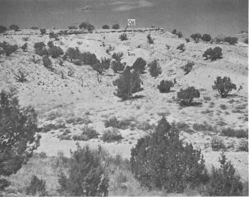
|
| FIGURE 12—Terrace gravel, interior of the Circle Cliffs area, near Burr Trail. Moenkopi Formation (Trm) and terrace gravel (Qg). |
The gravel deposits crop out on low flat-topped hills about 80-120 feet above the level of the present stream courses. The bedrock of all these hills is the Moenkopi Formation. The composition of the gravel varies with the location. The deposits in the White Canyon and Death Hollow drainages are weathered and friable and composed of angular fragments of red siltstone, sandstone, chert, and dolomite, which were probably derived locally from the Moenkopi Formation and the Kaibab Limestone. The gravel body at the head of Burr Trail is firmly cemented by carbonate and consists of sandstone and chert cobbles and pebbles, probably derived mainly from the Shinarump Member of the Chinle Formation, although minor amounts came from the Moenkopi and Kaibab.
The gravel deposits represent earlier levels of the stream system in the Circle Cliffs area. They are younger than the deposits veneering pediments in the extreme northwestern part of the area and evidently are older than the landslide deposits on the Chinle slopes, because the bases of these slides are at the bottoms of the deepest canyons in the area. The gravel deposits are probably middle to late Pleistocene in age, but their age and relation to the other Quaternary units are not precisely known.
LANDSLIDE DEPOSITS
A common type of landslide deposit in the Circle Cliffs area consists of large blocks of rock that have moved downslope with only slight distortion of the original bedding and structure and an overlying landslide rubble of the same type of rock (fig. 13). Most of the blocks are on the steep slopes of the Chinle Formation, but landslide blocks of Dakota Sandstone and Morrison Formation are found in Hall Creek Valley and on the mesas to the east of the valley. The blocks are generally mudstone capped with sandstone. Exposures of the blocks are generally poor because most are covered by a rubble of fragments of the same type of rock that constitutes the block.
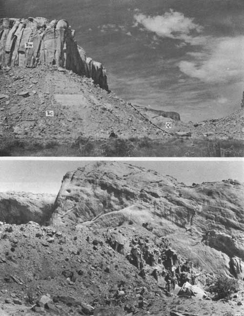
|
| FIGURE 13.—Landslide remnants. A, Block landslide in Silver Falls Canyon. Chinle Formation (Trc), Wingate Sandstone (Trw), and landslide deposits (Ql). B, Landslide rubble in the upper part of the "Red Slide"; demoiselles formed as a result of erosion. |
The block landslides commonly are mistaken by prospectors for deep-seated blocks of faulted bedrock. The blocks are as much as several hundred feet long, and the beds dip more steeply into the slope than do the beds in nearby outcrops (fig. 13A). The blocks may be single or they may be step faulted and have sandstone caps arranged in steps that parallel the face of the block and increase in height toward the rear, or higher, end of the block. On slopes of the Chinle the blocks consist stratigraphically of as much as 70 feet of Chinle, which may be overlain by as much as 100 feet of Wingate Sandstone. Blocks in Hall Creek Valley and on the mesas to the west consist of several tens of feet of mudstone of the Morrison and Dakota, generally capped by slightly faulted and rotated beds of Dakota Sandstone.
Other landslides consist of rubble that moved by creep, rockflow, and mudflow. Such rubble generally mantles the block landslides and many of the Chinle slopes. The upper surface of the rubble is rough and uneven and has a local relief of 30-40 feet produced mainly by boulder accumulations. It consists of mud derived from the Chinle Formation and sand and boulders (as much as 30 ft in diameter) derived from the Wingate Sandstone. Rubble similarly derived from the Morrison Formation and the Dakota Sandstone masks block landslides in Hall Creek Valley.
A large mudflow locally referred to as the "Red Slide" occurs in the southeastern part of the Circle Cliffs area. This mudflow, which consists of material derived from the Chinle Formation and the Wingate Sandstone, blocked Hall Creek Valley, as shown by 60 feet of finely laminated mudstone resembling lacustrine sediments that crop out upstream from the "slide" and overlie the mudflow material. The material composing the rubble landslide deposits is very well cemented, unsorted, and unstratified. The cementation is so strong that pillars or pedestals of slide material 10-20 feet high and 3-4 feet in diameter will support a boulder cap weighing about a ton. These pedestals (fig. 13B) were called demoiselles by Gregory and Moore (1931, pl. 28) and are erosional remnants of the upper part of the landslide deposit.
The landslides have reached into the bottoms of the deepest canyons in the Circle Cliffs area, and they postdate the latest period of canyon cutting. Some slides are Recent in age and overlie Recent alluvium, but most probably occurred during the latest glaciation of the area (Wisconsin age) when the climate was more humid than it is now.
OLDER ALLUVIUM IN HALL CREEK
A terraced alluvium as much as 100 feet thick crops out in Hall Creek Valley and is mapped with alluvium of Quaternary age (pl. 1). The upper surface of the deposit is about 100 feet above the creekbed near Thomson Mesa. The terraced alluvium is a moderately well cemented mixture of rounded cobbles and sand of local origin. At the "Red Slide" the gravel grades into fine-grained finely laminated gray to light-brown sediment. This change indicates that a small lake formed upstream from the slide.
The terraced alluvium is generally younger than most of the landslide material, but on the east side of Hall Creek it is overlain by landslide rubble consisting mainly of rock fragments from the Morrison Formation and the Dakota Sandstone. This alluvium may be equivalent to the late Wisconsin alluvium of Hunt (1956, p. 38).
FAN DEPOSITS
Fan-shaped deposits of unstratified sand and boulders spread out from the base of Wingate and Chinle landslide masses in the northern part of the Circle Cliffs area. The deposits consist of unstratified mixtures of sand and clay and sandstone boulders derived from the Wingate. The material probably was reworked from the landslide deposits by water washing over the edges of the cliffs behind the landslides.
The fan deposits are incised 10-15 feet by present-day stream gullies and are overlain by alluvium associated with the present stream system. The fan material is unweathered and probably is only slightly older than the alluvium lining the present stream courses.
TALUS
Talus, the loose rock rubble at the base of all steep cliffs in the area, was generally mapped as landslide rubble; only talus cones of significant areal extent, notably those in The Gulch, were mapped separately. The cones taper upward from a broad base and rest against cliffs of Wingate Sandstone and steep slopes of the Chinle Formation. The rock fragments in the cones are angular, a few inches to a few feet in diameter, and generally not firmly cemented together.
STREAM ALLUVIUM
Deposits of stream alluvium are widespread in the Circle Cliffs area, but the thickest and most extensive are in Hall Creek Valley and in the northern part of the Circle Cliffs interior. The alluvium generally is confined to flood plains and channels of the present streams. The deposits are from 10 to about 40 feet thick and consist of unconsolidated stratified or unstratified mixtures of locally derived sand, silt, clay, and gravel. Some of the material mapped as alluvium has been reworked by wind into dunes and less, and some, especially in Hall Creek Valley, is windblown material that has been partly reworked by water.
The alluvium has been terraced by erosion, probably since about 1880 (Hunt, 1956, p. 39), and its top lies about 10-25 feet above the present stream level. Where rainfall is adequate, the alluvium will support a lush cover of vegetation, but the deposits probably are too thin in most areas to provide a source of ground water adequate for even domestic use.
Most of the alluvium in the Circle Cliffs area is post-Wisconsin or late Pleistocene to Recent in age. Remains of Indian camps, identified by abundant scattered fragments of pottery and arrowheads, are fairly common in the northern part of the Circle Cliffs area wherever the land is tree covered. Most of the remains have been found in the upper few feet of the alluvium.
WINDBLOWN-SAND DEPOSITS
Deposits of windblown sand occur in Hall Creek Valley and on all the benches and mesas in the area. The deposits constitute a mappable unit in only a few places, notably in the extreme northwest and in the Escalante River area.
The mapped deposits are generally mesa- and bench-covering blankets a few tens of feet thick. Locally, great piles of sand extend down into the deepest canyons from the tops of the cliffs rimming the canyons. The sand is unconsolidated and mostly very fine to fine. The grains are angular to subangular, and their surfaces are pitted and striated. The sand deposits provide soil for growth of vegetation and also serve as ramps between the canyons and the tops of the benches, providing access for cattle.
| <<< Previous | <<< Contents >>> | Next >>> |
bul/1229/sec1.htm
Last Updated: 04-Jan-2010