
|
Geological Survey Bulletin 1508
The Geologic Story of Colorado National Monument |
TRIPS THROUGH AND AROUND THE MONUMENT(continued)
Through the Monument from West to East Entrances
| WEST ENTRANCE 10 REDLANDS VIEW |
AFTER TURNING SOUTH on Rim Rock Drive from the intersection with Colorado Highway 340 (Broadway), we cross the Monument's northern boundary and reach the checking station at the West Entrance, where a small entry fee is charged during the summer. At the first left turn we are in red beds of the Chinle Formation, then in sheared and broken beds of the Wingate Sandstone along the Kodels Canyon fault. At the easternmost loop of the road we may look southeastward across Lizard Canyon to the Lizard Canyon monocline (fig. 30), and if we look down the slope to the east we will see one of John Otto's well-built trails that formerly ascended the west side of Lizard Canyon to what is now the campground, long before Rim Rock Drive was built. Do not try to stop at the curve, however; play it safe, drive on, and park at Redlands View a quarter of a mile west. By walking about 50 feet north of the turnout, we get an excellent view to the west of the Kodels Canyon fault, as shown in figure 31. Just to the north of the fault are the sheared and broken beds of the Wingate Sandstone along the east end of this fault. | ||||
| NEW EARTHFILL |
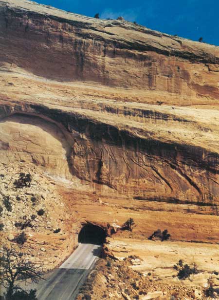
Just beyond the turnout the road curves left through a cut in the Wingate Sandstone and ascends the east side of Fruita Canyon. About a quarter of a mile from the parking area we get a good view (fig. 44) to the west of the new earthfill on Rim Rock Drive between the two tunnels. The original fill was washed out in a few minutes on August 8, 1968, by a cloudburst that dumped an estimated 4 inches of rain on the mesa west of Fruita Canyon. A culvert beneath the road just north of the north tunnel was wholly unable to cope with the resulting flood, part of which plunged over the cliff but most of which roared southward through the tunnel. According to the only known eyewitnesses—a couple from Ohio whose car was stalled in 18 inches of swift water in the lower tunnel—an estimated 4 feet of water flowing through the north tunnel soon separated the two tunnels by a gaping chasm and flowed down where the fill had been but moments earlier. They jockeyed their car back and forth in the south tunnel and retraced the route back toward Fruita. Later I viewed the chasm from the portal of the north tunnel and found it awesome indeed.
The road remained closed for 1-1/2 years until December 20, 1969, much to the annoyance and discomfort of both visitors and Monument personnel—particularly the latter. During the summer, the usual 16-mile daily round trip to the post office in Fruita via the West Entrance was increased to about 80 miles by way of the East Entrance. During the school season, wives of Monument personnel took turns driving a station wagon full of children on two daily round trips to the schools and post office in Fruita. Note in figure 44, taken only 6-1/2 years after the road was reopened, that small gullies already have been cut in the lower half of the new fill. Another local cloudburst could remove the new fill, but let us hope this does not happen! On the next curve to the east the road cuts entirely through the red Chinle Formation, which here has a measured thickness of 103 feet.32 From the base of the Chinle to about the creek crossing the road cuts expose the old Proterozoic metamorphic rocks, which here have a purple hue.
| ||||
| 11 BALANCED ROCK |
At the southernmost loop of the road is a parking area viewing Balanced Rock. The photograph for the frontispiece was taken from the hillside near the foot of the monolith. | ||||
| 12 HISTORIC TRAILS VIEW 13 FRUITA CANYON VIEW |
After the road turns north, we again cross the entire Chinle Formation, then penetrate the Wingate Sandstone through the two tunnels (turn on your lights) shown on all the maps and in figures 33 and 44. Just beyond the highest tunnel (turn off your lights) we reach Historic Trails View, with a sign noting the early expeditions that traversed the area. West from the parking area, but better yet by walking to the westernmost curve, may be seen the northern part of the Black Ridge Trail. This foot trail is part of the old stock trail over which sheep and cattle once were driven down to the Grand Valley from Glade Park and Piñon Mesa. The road then winds upward through a series of switchbacks cut into the Kayenta Formation to Distant View and then to a parking spot at the relatively new Fruita Canyon View, which affords a splendid view of Fruita Canyon. Figure 45 was taken from a point about a tenth of a mile to the east. On the right are housing facilities for Monument personnel.
| ||||
| 14 CAMPGROUND AND PICNIC AREA |
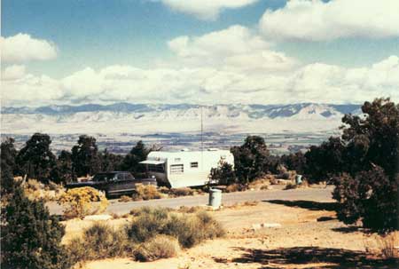
At the top of the hill just beyond the head of Fruita Canyon, two roads turn left; the first makes several loops through the modern campground and picnic area then returns to Rim Rock Drive; the second enters a large parking lot at the Visitor Center. Let us take the first road, then turn sharp to the left again just west of the Saddlehorn and explore the camp and picnic areas, which are on a gently sloping mesa of the Kayenta Formation dotted with piñon and juniper trees and bushes of many kinds. The Saddlehorn is an erosional remnant of the Entrada Sandstone. (See fig. 50.) The deluxe campground has both drive-through and back-in campsites, modern restrooms, tables, piped water, and grills. Two of the drive-through sites on the northernmost loop are shown in figure 46.
A view of the picnic area and parking lot is shown in figure 47. During the summer, evening slide talks are given by rangers at a small amphitheater just north of the Saddlehorn and to the left of the view shown in figure 47.
| ||||
| WINDOW ROCK |
An interesting quarter-of-a-mile self-guiding Window Rock Nature Trail leads from the northeast corner of the campground to Window Rock and loops back past Book Cliffs View, which contains a table beneath a ramada. Window Rock Trail connects with the scenic Canyon Rim Trail, which leads southwestward to the Visitor Center. Views of Window Rock and Monument Canyon from Canyon Rim Trail are shown in figures 48 and 49.
| ||||
| VISITOR CENTER MONUMENT HEADQUARTERS |
After we return to Rim Rock Drive, a double left turn brings us to a large parking lot. We are now at the Visitor Center and Monument Headquarters, which is well worth a visit. In the front of the building are modern restrooms and a drinking fountain. Inside the lobby may be purchased film, slides, post cards, maps, booklets, and reports. A narrated slide show and museum help materially in conveying just what the Monument has to offer. I was pleased at being asked to contribute several of the geologic exhibits, partly with the aid of former Survey artist John R. Stacy. From the back door a path leads to a fenced overlook for viewing an arm of Monument Canyon. The overlook also is the beginning of Canyon Rim Trail which connects about half a mile to the northeast with Window Rock Trail at Book Cliff View. | ||||
| 15 GAP IN ROCK RECORD |
Half a mile southwest of the parking lot is one of the narrowest stretches of Rim Rock Drive at the edge of a Wingate cliff that actually overhangs. But do not worry, it is well protected by a rock wall. At the head of the canyon is a large jumbled landslide of the Morrison Formation that has covered the cliff of Entrada Sandstone. Along the narrow stretch and just beyond the landslide are excellent views on the right of the erosional unconformity between the eroded surface of the Kayenta Formation and the overlying Slick Rock Member of the Entrada Sandstone, a view of which is shown in figure 15 and a discussion of which is given on pages 35 to 39. | ||||
| 16 PIPE ORGAN |
From the next parking area to the northeast at Pipe Organ Overlook we may hike half a mile over Otto's Trail to an overlook of the Pipe Organ; a view of the Pipe Organ from the northwest is shown in figure 49. From about the middle of this trail we may look to the northwest across the canyon to the Visitor Center and the Saddlehorn (fig. 50).
| ||||
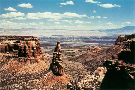
| 17 INDEPENDENCE VIEW |
At the next parking area at Independence View we see Independence Monument (fig. 51) from quite a different angle than the photograph shown in figure 6. This view clearly shows it to be a thin erosional remnant of a narrow wall that once connected mesas to the northeast and southwest and which separated the two entrances of Monument Canyon.
| ||||
| 18 GRAND VIEW |
Grand View, six-tenths of a mile farther southeast, affords excellent views of several features in and near Monument Canyon. A short improved trail to the northeast leads to a sandstone ledge from which the infrared photograph for the front cover was taken. The trail then veers eastward to a fenced cliff-top viewpoint from which one may look nearly straight down to a stretch of Monument Canyon Trail. You may see hikers on the trail or buffalo in the canyon. The photograph for figure 6 was taken from a point just north of the north end of the parking area. | ||||
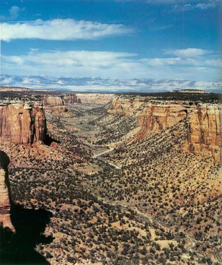
| 19 MONUMENT CANYON VIEW |
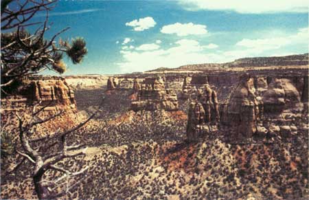
Another 1-1/3 miles takes us to the next parking area at Monument Canyon View, from which one may walk a short distance to the northeast. The photograph shown in figure 13 was taken from a point northeast of the parking area. From the head of Fruita Canyon to Monument Canyon View, Rim Rock Drive is on a bench of the Kayenta Formation that separates the two lines of cliffs. We must now leave this bench, however, because from near Coke Ovens Overlook to beyond Artists Point the bench ceases to exist, and the Entrada, Kayenta, and Wingate form virtually a single cliff. Moreover, we must get up into the Morrison Formation in order to cross the divide between Monument and Ute Canyons. For these reasons, in the next three-quarters of a mile south of Monument Canyon View the road cuts upward through the entire Entrada Sandstone. Just beyond the first curve are quarries on the right from which curb and building stones were cut by the Civilian Conservation Corps in the 1930's for protecting overlooks and narrow stretches of road. At the southwest end of this stretch is another parking area at Coke Ovens Overlook, which provides good views of the north side of the Coke Ovens. | ||||
| 20 COKE OVENS OVERLOOK |
The next parking area a quarter of a mile to the southwest is the Monument Canyon Trailhead of the long trail to the mouth of Monument Canyon and of a short trail to the Coke Ovens. | ||||
| 21 ARTISTS POINT |
Half a mile to the southeast takes us to a large parking area at Artists Point, which offers a wide variety of scenic views. The best exposure of the Summerville Formation in the entire area that I mapped33 is on the west side of the road, as shown in figure 20. A short trail leads down to a fenced overlook for viewing the Coke Ovens to the north (fig. 11) and Monument Canyon to the northeast.
| ||||
| 22 HIGHLAND VIEW DIVIDE |
The Summerville Formation is exposed on the right for about the next half a mile. In the next three-quarters of a mile to Highland View the roadcuts are in the sandstone ledges of the Salt Wash Member of the Morrison Formation. Another half a mile through massive Salt Wash sandstones takes us to the second highest point on Rim Rock Drive—the divide between Monument and Ute Canyons, altitude 6,593 feet. From here we may look far to the south across Glade Park to high Piñon Mesa—the highest part of the Uncompahgre Plateau northwest of Unaweep Canyon, where the altitude is about 9,500 feet. | ||||
| 23 LIBERTY CAP TRAILHEAD |
Halfway down the hill to the south is a parking area on the left at the head of Liberty Cap Trail, which goes eastward about 6 miles to Liberty Cap—a prominant conical point atop the Wingate cliff just west of the mouth of Ute Canyon, which appears on the left skyline of figure 38. From there, the trail descends about 2 miles to a gate in the boundary fence at the mouth of Ute Canyon. The roads connecting the gate with South Camp Road (fig. 3) were reported (1979) to be closed to foot travel by private landowners, so hikers reaching this point must either retrace their steps to the parking area at the head of the Liberty Cap trail, or return by a primitive trail up main Ute Canyon, turn right up the west arm of the canyon, and regain Rim Rock Drive by a short switchback trail noted on page 109. However, the Park Service hopes that in the future some sort of corridor can be established to connect the trailhead with the nearby roads. Most of the "trail" up Ute Canyon is the normally dry channel of the creek, so hikers should watch out for flash floods. The round trip by Liberty Cap Trail alone is about 16 miles, and if the return trip is made by Ute Canyon the total distance is about 13 miles. Accordingly, hikers should allow a full day and carry food and water. | ||||
| GLADE PARK ROAD |
A quarter of a mile west of the Liberty Cap parking area in the west arm of Ute Canyon is a junction with a gravel road that leads 5 miles south to the Glade Park General Store and Post Office, where groceries, beer, gasoline, and fishing and camping supplies are available. Glade Park connects with scenic roads leading east, west, and south. Later, we will cover in more detail a round trip from the intersection in Ute Canyon to one near Cold Shivers Point, and another round trip from Glade Park around the head of No Thoroughfare Canyon and back to Grand Junction via the Little Park Road. But to continue with the trip through the Monument—from the intersection with the gravel road to Glade Park, Rim Rock Drive turns abruptly to the southeast and follows the west arm of Ute Canyon for some 3 or 4 miles, past many interesting points. For the next 1-1/3 miles to the first culvert, which crosses a large tributary, the roadcuts are in the Summerville Formation and Entrada Sandstone. The photographs in figures 16 and 17 were taken looking north from the culvert and from just northwest of the culvert, respectively. | ||||
| 24 FLOOD |
One day when my family and I were approaching the culvert from the west, we heard a roar like an express train. Looking to the south we saw that a severe thundershower was occurring on the headwaters in Glade Park, so we raced ahead and parked east of the culvert just in time to see and hear a 4-foot wall of red water come roaring down the tributary, rolling boulders along as if they were basketballs. Unfortunately, we had no time to ready or use a camera, so we simply raced down the road embankment and through the trees and brush to the north in time to see the flood plunge eastward over a 350-foot cliff of the Wingate Sandstone to the canyon below. This illustrates the need for caution when following or crossing "dry" washes in the desert in stormy weather or when there are storms in the distance. | ||||
| 25 UPPER UTE CANYON VIEW |
About two-tenths of a mile northeast of the culvert is Ute Canyon View, which affords good views of the northeast cliff face of the west arm of Ute Canyon. | ||||
| 26 FALLEN ROCK OVERLOOK UTE CANYON TRAILHEAD |
For the next 7-1/2 miles Rim Rock Drive is once again on a bench of the Kayenta Formation between cliffs of the Entrada and Wingate Sandstones. From Upper Ute Canyon View the road goes southeastward along the canyon rim about three-tenths of a mile to a parking area. A short trail leads down from the parking area to fenced Fallen Rock Overlook; the view shown in figure 35 is from this point. As noted in the caption of figure 35, and on page 108, the Ute Canyon Trail zigzags down the slope from the road a quarter of a mile southeast of the parking area, but there is no parking area at the trailhead, so it is safer to park at Fallen Rock Overlook and walk to the trailhead. The connection with this trail and the Liberty Cap Trail also is discussed on page 108. On one hike down this trail we saw two elk, which is a rare sight at such a low altitude, for they generally stay on or near Piñon Mesa. | ||||
| 27 UTE CANYON |
About a mile to the southeast, just beyond the steep dropoff on the left, there is room to park, walk a short distance through the trees to the east, and observe a fine view of main Ute Canyon, as shown in figure 52. Just beyond on our right are the cliffs of the mottled salmon-and-white Slick Rock Member overlain by the all white Moab Member, as shown in figure 18 and described in the accompanying text.
Half a mile southeast, where the road makes a gentle U-turn and continues northeastward, we reach the highest point on Rim Rock Drive at an altitude of about 6,640 feet. Note that the piñon ??? and juniper are larger, and the bushes are larger and greener at this altitude, for the average precipitation increases as we go higher. | ||||
| 28 LOWER UTE CANYON VIEW |
About a mile northeast of the highest point on the road is a large parking area on the left, from which a short, shaded trail leads to a fenced overlook called Lower Ute Canyon View, which faces the northwest arm of Ute Canyon across the main canyon. | ||||
| 29 RED CANYON OVERLOOK |
About half a mile beyond this parking area, we reach a small parking area at Red Canyon Overlook, from which the photograph shown in figure 12 was taken. The dark green bush of Mormon Tea in the right foreground of figure 12 is one of the largest I have seen in the Monument. The reasons for the differences between the left and right walls of the canyon are discussed on pages 79 and 80. The ripple-marked curbstones of white sandstone in the parking area were quarried from the Moab Member of the Entrada Sandstone northwest of Fruita Canyon, as noted on page 96. | ||||
| 30 DS ROAD COLD SHIVERS POINT |
Another 2-1/2 miles around the south rim of Red Canyon and the head of Columbus Canyon takes us to the junction with the paved county road known as the DS Road, which leads south and southwest to Glade Park and to the head of No Thoroughfare Canyon. This important intersection will be included in trips through Glade Park and around the head of No Thoroughfare Canyon, so it will be discussed later. Meanwhile, we will continue our trip eastward from this intersection. About a third of a mile to the northeast is a large parking area, with a path leading to a fenced overlook at the rim of Columbus Canyon for viewing Cold Shivers Point—perhaps the most aptly titled feature in the Monument (fig. 53). A primitive path leads from the overlook to the toadstool-shaped platform at upper right, on which some visitors dare to stand, but not me. When the old, steep Serpents Trail was the only route for autos to ascend from the East Entrance, barrels of water were kept at this parking area to quench the thirst of boiling radiators.
| ||||
| 31 HEAD OF SERPENTS TRAIL |
After leaving the parking area, the downgrade on the Kayenta Formation begins to steepen to the northeast until it becomes advisable to shift into second gear. In about half a mile we descend a series of steep switchbacks cut into the Wingate Sandstone on the steepening Ladder Creek monocline (figs. 8, 29), and we reach the present upper end of the old Serpents Trail (fig. 54), which is now an interesting foot trail. As noted earlier, it is convenient to hike down this steep 2-1/2-mile trail and to have one member of the party drive ahead and await the hikers at the parking area in the Devils Kitchen Picnic Area, near the foot of the trail. One of many rewarding views seen during the hike is shown in figure 55, another was seen in figure 10.
| ||||
| FOOT OF SERPENTS TRAIL |
Just beyond the lowest switchback shown in figure 54, we penetrate the Wingate Sandstone through a tunnel, the south portal of which is shown in figure 56. After we drive through a deep cut in the Wingate Sandstone just south of the tunnel, we cross the entire red Chinle Formation, then descend a series of switchbacks in old Proterozoic rocks. The Chinle Formation is crossed again near the foot of the hill, where it is about 80 feet thick,34 then we recross the Wingate Sandstone and Kayenta Formation to the parking area in the Devils Kitchen Picnic Area, near the foot of the old Serpents Trail.
| ||||
| 32 DEVILS KITCHEN |
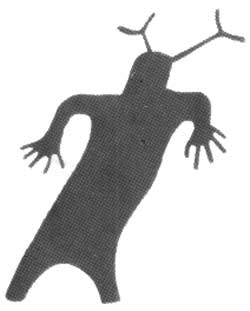
An improved marked trail leads southward from parking area at the foot of the Serpents Trail, crosses No Thoroughfare Canyon, and continues as an unimproved trail to the Devils Kitchen, a view of which is shown in figure 57. The petroglyphs shown in figure 4 are northeast of this parking area. Those interested in seeing them should inquire at the ranger station or checking station at the East Entrance.
| ||||
| EAST ENTRANCE |
Just beyond the parking area, near the foot of the old Serpents Trail, a road turns left to a larger parking area for the Devils Kitchen Picnic Area, where covered tables, grills, and water are available. Just beyond we pass the checking station and housing facilities for Monument personnel at the East Entrance of the Monument. During the summer, fees are collected at this checking station from persons entering the Monument. A well just east of the housing area obtains water from the Entrada Sandstone to supply the houses and picnic area.
|


| <<< Previous | <<< Contents >>> | Next >>> |
bul/1508/sec12c.htm
Last Updated: 8-Jan-2007