|
Geological Survey Bulletin 612
Guidebook of the Western United States: Part B |
ITINERARY

|
|
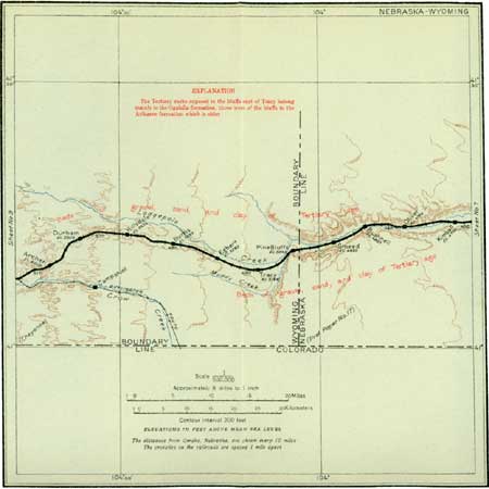
SHEET No. 8. (click on image for an enlargement in a new window) |
|
Kimball. Elevation 4,704 feet. Population 454. Omaha 451 miles. |
West of Sidney the "mortar beds" of the Ogalalla formation, which continue to make conspicuous bluffs north of the track in many places, contain the fossil bones of many animals.1 These have been described by Prof. W. B. Scott, Prof. H. F. Osborn, and others. In these bluffs seen below the cap rock may be the Brule clay, the youngest formation of the White River group,2 of Oligocene (Tertiary) age. (See table on p. 31.) The exposures in the Lodgepole Valley are not so conspicuous as those in the North Platte Valley, a little farther north, owing to the covering of grass which protects the surface from erosion. In the North Platte Valley badlands are developed at many places on the Brule clay, and curious buttes, remnants of this clay, have been left by erosion, such as those known as The Jail (Pl. VII, A, p. 41) and Chimney Rock, which served as a landmark to many emigrants in the early days.
1See footnote on, p. 34.
2The White River group, which has been studied mainly in the bad lands of the Black Hills, has long been a favorite collecting ground of the paleontologist. Fossil bones have been found in many parts of the group, and those of certain animals are so abundant as to give their names to the rocks containing them, such as Titanotherium beds, Oreodon beds, and Protoceras sandstone. More complete information on these fossils may be found in the works of Profs. Scott and Osborn. (See p. 230.)

|
| PLATE VII.—ROCKS OF OLIGOCENE AGE AND RESTORATIONS OF ANIMALS THAT LIVED IN CENTRAL NORTH AMERICA DURING THE OLIGOCENE EPOCH. A, JAIL ROCK, NORTH OF SIDNEY, IN WESTERN NEBRASKA, THE LOWER PART OF WHICH CONSISTS OF BRULE CLAY; B, AN AMERICAN RHINOCEROS (AFTER OSBORN); C, "GIANT PIGS," 3 OR 4 FEET HIGH (AFTER SCOTT); D, TITANOTHERES, ALMOST AS LARGE AS THE MODERN ELEPHANT (AFTER OSBORN); E, PROTOCERAS CELER, ANIMALS THE SIZE OF THE MODERN ANTELOPE (AFTER SCOTT). B—E published by permission of The Macmillan Co. |
|
Smeed, Nebr. Elevation 4,933 feet. Omaha 468 miles. |
After leaving Kimball the train passes Oliver and Bushnell before reaching Smeed. The "mortar beds" which were observed farther east at the top of the bluffs descend to the valley floor west of Kimball and are not conspicuous, but west of Smeed they rise again in bluffs, become more prominent, and terminate in Pine Bluffs. Just west of Oliver, which is only a signpost, may be seen to the left (south of the railroad) a small reservoir for the storage of irrigation water, which is used in the valley farther downstream.
Just before entering Pine Bluffs the traveler sees to the right, north of the track, a stone monument marking the boundary between Nebraska and Wyoming.
| <<< Previous | <<< Contents >>> | Next >>> |
bul/612/sec10.htm
Last Updated: 28-Mar-2006