
|
Geological Survey Bulletin 845
Guidebook of the Western United States: Part F. Southern Pacific Lines |
ITINERARY
NEW ORLEANS, LA., TO LOBO, TEX.
|
New Orleans. Elevation 6 feet. Population 458,762.1 |
The journey westward over the Southern Pacific lines begins at New Orleans, one of the largest cities in the limited States and one that is unique in character, history, environment, and economic relations. Founded in 1718 by Capt. Jean de Bienville, as a nucleus of a French settlement in America, it was named in honor of the Duke of Orleans, the regent of young Louis XV. It was colonized mostly by people from France, and a part of the population still follows the customs and traditions of their French ancestors. The city consists of two portions, presenting the strong contrast of the quaint old French with the new American.
1The figures given in this book for population of incorporated places are those of the United States Census for 1930. For some of the small places the population has been estimated, and such figures are marked with an asterisk (*).
The area of the original palisaded city is now known as the "Vieux Carré"; it centers about the old St. Louis Cathedral in the Place d'Armes, now Jackson Square, laid out in 1720 by Le Blond de la Tour, Bienville's engineer. A few French and a great many Spanish houses, built from 100 to 150 years ago, still remain; once the homes of aristocratic and distinguished people, they are now mostly converted into trading establishments and rooming houses. The Place d'Armes has been the scene of many historic events, notably the gathering of troops to repel the expected attack of the Natchez Indians in 1728, the reception of the Acadians driven from Nova Scotia by the British in 1755, the arrival of Gem. Alejandro O'Reilly in 1769 to take possession after the transfer of the colony from France to Spain, and the triumphant return of Gen. Andrew Jackson from the Battle of New Orleans January 8, 1815. Here also were made the three great transfers of Louisiana Territory subsequent to the treaties of cession—first from France to Spain in 1764, then from Spain to France in 1803, and finally, in 1803, from France to the United States, a transaction very distressing to many of its Creole inhabitants but resulting quickly in marked increases in property values and population.
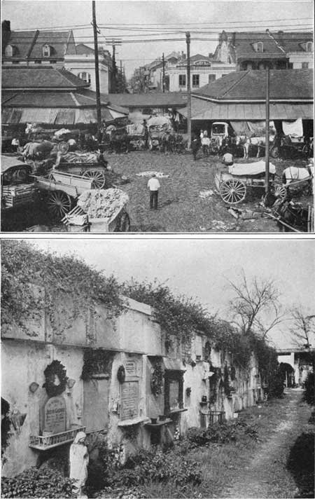
The cathedral, erected in 1795 by Don Almonaster y Roxas, who is buried under the altar, replaced a small church built in 1718 and destroyed by fire in 1788. Next door is the Cabildo, built in 1795 for the Spanish Legislature and for nearly a century the seat of government. Adjoining the cathedral is the Presbytère, formerly the house of the Capuchin priests, used later for the civil courts of the city. This and the Cabildo are now part of a free museum and the home of the Louisiana Historical Society. Not far distant is the house built for Napoleon, who was to have been rescued from St. Helena by one of Lafitte's pirate crew had he not died before the expedition could start. Many other buildings near by have great historic interest and also present peculiarities of construction not seen elsewhere. The city was largely destroyed by fires in 1788 and 1794; in its rebuilding the Spanish influence has affected the architecture. The French market (shown in part in pl. 3, A), on the site of the market built by the Spaniards in 1791, attracts many tourists. Not far away (1727 Chartres Street) is the Archbishopric, erected in 1734 for an Ursuline convent, said to be the oldest building now standing in the Mississippi Valley. Rampart Street is on the outer line of the city defenses, built in 1793 by Baron de Carondelet, then Spanish governor, and the Terminal Station is on the site of Fort Burgundy. The old cemeteries are filled with vaults, many with three tiers of niches for caskets, for originally the water level was so near the surface that burial in the ground was impracticable. (See pl. 3, B.) The Spanish fort where Bayou St. John joins Lake Pontchartrain marks the place where the first colony landed. The Chalmette Monument, in the lower end of the city, commemorates the battle in which Gen. Andrew Jackson and his 5,000 backwoods militia routed a good-sized British army under Sir Edward Pakenham in 1815. The mint, erected in 1821, the oldest one in the country, was built on ramparts of General Jackson's old fort. The Pontalba buildings, still in use, were erected in 1849 and were long used as high-class apartment houses. In 1862 New Orleans was captured by Gen. Benjamin Butler and held by the Union forces until the end of the Civil War.
|
|
PLATE 3.—A, OLD FRENCH MARKET IN VIEUX CARRÉ, NEW ORLEANS.
Looking out a typical street in center. B, TYPICAL GRAVEYARD IN NEW ORLEANS. In the early days the water plane was so near the surface that interment was undesirable. |
New Orleans is built on the "Isle d'Orléans" (no longer an island) in a great crescent-shaped bend of the Mississippi 107 miles above its mouth (South Pass). It lies on the slope of a natural levee, or low ridge built up by the river, and comprises an area of 44 square miles. Most of the city is below the high-water level of the river, and parts of it are below the level of the Gulf of Mexico.3 The first levee, built in 1727, was 900 feet long; eventually, as levees were extended, the city developed in a wide, deep saucer, out of which no drainage could flow. Throughout its history, therefore, it has had to contend with flood overflows, rain water, seepage, and sewage removal. Now, however, pumps with a capacity of 7,000,000,000 gallons a day lift surplus water into Bayou Bienvenue and Lake Pontchartrain, At times of heavy downpours the volume of water to be handled is very great,4 but it is claimed that the present pumping system can dispose of a rainfall of 14 inches in 24 hours. The annual precipitation is 57 inches. The sewage is pumped to an outlet down the river, 20 feet be low mean water level. Surface water and seepage are collected in large canals, and by this means the general ground-water level has been so greatly lowered that cellars are practicable and graves can be dug where formerly all interments were made in tombs.
3The land slopes down from the river bank into two basins 1 foot or more below sea level—one north of Claiborne Avenue and another in the neighborhood of Earigny and Elysian Field Avenues. North of these basins there is a ridge with crest 3 to 5 feet above sea level that was probably built by Bayou Sauvage and later cut through by Bayou St. John. North of this ridge the land is less than 1 foot above sea level and slopes gently to Lake Pontchartrain, The sediments under New Orleans are sand, silt, and clay, probably of the overflow or levee deposits, though they may have been deposited in the Gulf in front of an offshore bar. In the sediments are undecayed cypress stumps, some as deep as 12 feet below sea level. At depths of more than 43 feet below sea level recent marine shells are found (Trowbridge). It has not been definitely determined how much true delta material underlies New Orleans.
4One night in April, 1927, a fall of 13 inches of rain caused such an inundation that the levees had to be opened at Poydras, 15 miles below the city, to let out the flood waters, an expedient that cost the city $5,000,000 for damages. Now a spillway 35 miles above the city serves to divert water into Lake Pontchartrain in times of river flood.
In these days of large buildings it has been difficult to obtain stable foundations, but by the use of many wooden piles, in some places 80 feet long, office buildings and hotels of considerable height have been erected.5 One notable structure is the auditorium, which has a seating capacity of 12,000 and is used for the great balls of the Mardi Gras festival.
5In building most of the railroad embankments a great canal was first excavated to remove mud and then filled with sand. For foundations in the lower part of the city 30 feet or more of silt is removed to a layer of long-buried cypress stumps, through which closely spaced piling is driven to form a mesh which by friction will sustain heavy buildings. One high building with a foundation of this character has settled a few inches, but the subsidence has been so uniform that there is no rupturing. In some places even the lowering of water level by drainage has resulted in the decay of wooden substructures with consequent settling of buildings.
There are four great institutions of learning in New Orleans: Tulane University (formerly the University of Louisiana), the H. Sophie Newcomb Memorial College (the women's department of Tulane University), Loyola University, and the Isaac Delgado Central Trades School. There are many parks, libraries, churches, and clubs. About two-thirds of the population are native whites. The city water supply, of about 50,000,000 gallons a day, is pumped from the river, and plans have been developed to double this amount; the water is purified by treatment, so that its quality is satisfactory. New Orleans once had a high death rate, but this has been reduced by sanitary measures to 12-1/2 per 1,000 for the resident population, according to local records. The dreaded scourges of yellow fever and bubonic plague have been eliminated, and malaria has been made rare.6 Although in latitude, 30°, and with a warm climate for much of the year, the mean annual temperature is only 69.3°, with rather small seasonal range from 54° in January to 82.4° in July.
6In the summers of 1853 to 1855 there were 37,000 deaths from yellow fever, at times at the rate of 300 a day. In 1889 the death rate from malaria was 156 per 100,000; now it is 1. Since the present water supply has been established the death rate from typhoid fever is only 2 per 100,000. (Data from New Orleans Association of Commerce.)
New Orleans has become a great commercial center, as much of the vast foreign commerce of the Mississippi Valley and central United States passes through its portals. It is reached annually by about 1,000 vessels whose capacity in 1928 amounted to 11,204,573 tons, according to the New Orleans Association of Commerce. It is a port of entry for a large part of our business with Latin-American ports. It claims to be the largest market in the United States for cotton, bananas, rice, and burlap and one of the largest for sugar, mahogany, coffee, furs, hides, and naval stores. According to statements furnished by the New Orleans Association of Commerce from 350,000,000 to 450,000,000 pounds of coffee, 500,000 bales of cotton, and 23,000,000 bunches of bananas are handled every year. The grain elevators have a capacity of 2,622,000 bushels, The imports in 1928 amounted to $208,430,587 and the exports to $384,597,092, all transported on the Mississippi River through, the great passes at its mouth. This river at New Orleans is 2,000 feet wide and in places 200 feet deep. Although there is provision for many vessels on the city's long water front, additional space to accommodate the heavy traffic has been obtained by the construction of a canal 30 feet deep and 5 miles long, connecting the river with Lake Pontchartrain. This canal has a huge lock to provide for the drop from river to Gulf level and cost $21,000,000.
In order to permit the access of large ocean-going vessels to New Orleans, two of the outlet channels, South Pass and Southwest Pass, at the mouth of the Mississippi River, originally having only 10 or 12 feet of water, have been dredged to depths of 30 to 35 feet, with widths of 750 to 1,000 feet. The filling of these channels by the great volume of silt carried by the river is prevented by a current of sea water which passes under the fresh-water outflow, a deep-seated eddy which keeps the sediment in suspension and carries it off. Great care, however, has to be taken to prevent the river from creating new passes, which would decrease the strength of the current in the main channel and diminish its effectiveness in transporting sediment.
New Orleans is also a great manufacturing center, the 1929 output of its 786 factories being valued at $148,388,315, according to the United States Census. Its manufacturing industries have the great advantage of natural gas from the Monroe field, in Louisiana, cheap oil, and water transportation. Sugar, cane sirup, cotton goods, and celotex (board made from bagasse, or sugarcane refuse) are important local products.
| Louisiana. |
Louisiana, with an area of 48,506 square miles, had in 1930 a population of 2,101,593, an increase of nearly 17 per cent since 1920, placing it twenty-second in rank in the United States. Owing to large areas of thinly populated swamp lands, however, the average density of population is only 43 to the square mile. New Orleans is by far the largest city. Shreveport, which is growing rapidly, is next in size; Baton Rouge (the capital), Monroe, Alexandria, Lake Charles, and Lafayette are considerably smaller.
The greater part of Louisiana consists of lands less than 100 feet above sea level, and a large area along the Mississippi River and the Gulf coast stands at less than 50 feet. The alluvial valley of the Mississippi occupies all of the eastern half of the State. There are more than 4,700 miles of waterways, but some of them are small. A great intracoastal canal utilizing many of these natural waters is in course of construction. (See p. 17.)
The principal products of Louisiana are agricultural, with crop values of $161,078,688 in 1929,7 but only about one-fifth of the area is under cultivation. Furs, lumber, petroleum, natural gas, and miscellaneous manufactures, especially sugar refining, are sources of large income. In 1929, 402,422 acres of rice yielded 16,317,463 bushels, 1,945,354 acres of cotton yielded 798,828 bales, and 205,394 acres of cane yielded 208,000 short tons of sugar.8 Corn production was about 20,000,000 bushels. According to data from the New Orleans Association of Commerce, the lumber cut in 1928 was 2,278,442,000 board feet, the State ranking second in the production of pine lumber, and its value, together with turpentine, rosin, tar, and other naval stores and wood pulp, was $154,766,819. The petroleum production in 1931 was 21,804,000 barrels, according to the United States Bureau of Mines. Refining of petroleum is one of the principal industries, with an output in 1929 valued at $151,966,142, or more than one-fifth of the total value of the manufactures of the State. The sugar refineries in 1929 had a production valued at $74,706,373. Natural gas is obtained in several fields. The Monroe field gave 103,000,000,000 cubic feet in 1931, much of which was piped to many cities, although some was used at the source for the production of carbon black, of which Louisiana produced 28,740 tons in 1931. (U. S. Bureau of Mines.)
7Statistics are taken from United States Census reports except as otherwise stated.
8Sugarcane was introduced from Santo Domingo by Jesuits in 1751, but not until 1780, when slave labor was utilized, did its cultivation become profitable. Louisiana grows about 95 per cent of the sugarcane raised in the United States and also imports considerable raw sugar for its refineries. For a while the extinction of the sugar industry was threatened by a blight called the mosaic disease, but it was saved by the substitution of cane imported from Java, which not only resists the disease but is more hardy in general, has a higher sugar content and tougher fiber, and requires replanting only every second or third year, instead of annually. According to data furnished by the New Orleans Association of Commerce, 200,000 acres of this cane was growing in 1929, with a yield of over 18 tons of cane to the acre, or more than double that of the earlier cane, and yielding 160 pounds of sugar to the ton, instead of 138 pounds. The 1929 sugar crop ranked next to cotton and rice in value. Sugarcane makes a heavy draft on the soil, but many fields have been producing it for 100 years or more.
|
|
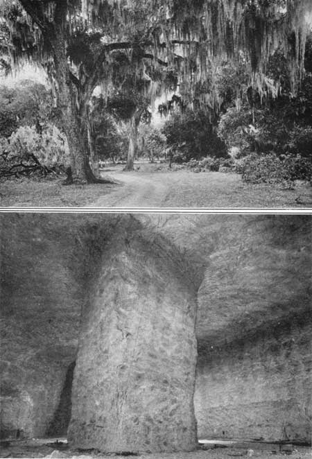
PLATE 4.—A, WOODLAND SCENE, SOUTH-CENTRAL LOUISIANA.
Showing the parasitic Spanish moss. B, GALLERIES IN THE SALT MINE, AVERY ISLAND, LA. |
There is a large yield of fruits and early vegetables in Louisiana, and pecan nuts are an important product. The annual output of oranges, both Louisiana Sweets and Satsumas, is about 82,500 boxes. On account of the mild climate there is a long growing season, and in places three successive field crops can be raised in a year. Pastures are perpetual. Corn, which is increasing in popularity, yields 30 to 75 bushels to the acre. Rice, one of the principal crops, occupies a wide area in the southwestern part of the State, Louisiana ranking first in the United States in rice production. Hay is raised in large amounts, also lespedeza, or Japanese clover, which grows 12 to 15 inches high. Although many forest areas have been cut off, reforestation is in progress, and 500,000 acres has been planted in pines, to be sold years hence for lumber and pulp or to furnish turpentine. These plantings are mostly in areas not favorable to agriculture. Meanwhile, in order to conserve trees now developing, logs are imported to help supply the great sawmills at Bogalusa.
There are three game preserves in Louisiana, created to give sanctuary to the wild birds that live in or visit the State in vast numbers. These preserves are Avery Island, 34,000 acres; Rockefeller Preserve, 104,000 acres; and Russell Sage Preserve, 94,000 acres.
Louisiana is the largest producer of furs in the United States, for its great marsh areas sustain a vast number of fur-bearing animals. The muskrat is the one principally sought, and during the open season of 1928-29 about 5,000,000 pelts of this animal were obtained, at a value of about $1 each. These, with opossums, raccoons, minks, skunks, otters, wildcats, and foxes, yielded 6,000,000 pelts (equal to the Canadian production), valued at $8,500,000, according to data furnished by the New Orleans Association of Commerce. The pelts are all obtained by resident trappers, who in most places pay a rental for the land on which the trapping is done.
Louisiana produces many terrapin and shrimp, and according to local reports it ships 6,000,000 pairs of frogs' legs a year. Oysters are marketed in large numbers, and there is a vast area available for their culture, with the advantage that the oysters mature here in two years. The great shell reefs on the Gulf shore are valuable for lime, road metal, chicken feed, etc.
Salt is one of the great resources of the State, with a production of 529,280 tons in 1931, valued at $1,962,690, according to the United States Bureau of Mines. A part of the salt is used for the manufacture of sodium carbonate, soda ash, caustic soda, and sodium sulphite, used for glass, in paper making, and in dyeing. Large factories in New Orleans produce these and other chemicals.
The Gulf region has an annual rainfall averaging about 62.5 inches, and although high temperatures occur during the summer, the heat is tempered by nearly constant breezes from the Gulf; these breezes also diminish the chill of the winter.
The history of Louisiana is full of interesting events, of which the first was the discovery of the mouth of the Mississippi River by the Spanish explorer, Pánfilo de Narváez in 1528. In 1542 Luis de Moscoso, who had accompanied Hernando de Soto to the mouth of the Red River, descended to the mouth of the Mississippi and sailed down the Gulf coast to Mexico. In 1673 Jacques Marquette and Louis Joliet, sent by the Canadian colonial government to find an outlet to the West, descended the great river to its junction with the Arkansas River, and in 1682 René Robert de La Salle sailed to its mouth, taking possession of the region under the name of Louisiana, in honor of his patron Louis XIV. The region claimed by La Salle included the entire drainage basin of the Mississippi River and much of the Gulf coast. Three years later he returned with a colony which he expected to locate near the mouth of the river, but he missed the Mississippi and landed instead at Matagorda Bay, in Texas, near which he was murdered in 1687. In 1699 Pierre d'Iberville, a French naval officer, landed at New Orleans with a colony, the first permanent settlement of the region, but he established it in Spanish territory (near Biloxi, Miss.). In 1712 Antoine de Crozat, a French merchant, obtained the exclusive right to trade in "Louisiana," but he surrendered this grant in 1717 to the Company of the West, which began sending out colonists. In the following year Capt. Jean de Bienville, a brother of Iberville, landed a colony of 68 persons at the site of New Orleans. In 1719 the first cargo of slaves arrived from Africa, valued at $150 each. This was just a century after the first slave cargo landed at Jamestown, Va. The seat of government was established in 1722 at New Orleans, and in 1726 the settlement had a population of 800. Life was made difficult by floods, Indians, diseases, and hurricanes. November 3, 1762, France, finding the territory a burden, ceded the portion west of the Mississippi, together with the city and island of New Orleans, to Spain in the secret treaty of Fontainebleau; the next year the remainder of Louisiana, east of the Mississippi, was ceded to England. The boundary between Spanish and British possessions, exclusive of the Isle of Orleans, was defined as the center of the Mississippi River. Spain, fearing that the settlements to the north would interfere with the interests of her possessions to the east, endeavored to defeat progress by prohibiting access to the mouth of the river. In 1800, in the secret treaty of San Ildefonso, Spain returned to France the area west of the Mississippi which she had acquired in 1762, but the actual transfer of authority was postponed for three years. On April 30, 1803, Napoleon ceded this territory to the United States for the sum of 60,000,000 francs and the assumption of certain claims against France. The part of Louisiana east of the river which was known as West Florida was ceded in part to Spain and in part to the United States by Great Britain in 1783. The Florida Purchase, effected by the United States in 1819, completed the transfer of Louisiana Territory.
The part of the State lying west of the Mississippi River was organized in 1804 as the Territory of Orleans, and in April, 1812 (the year the first steamboat made the trip from Pittsburgh to New Orleans), it was admitted to the Union under the name Louisiana. The area lying east of the river, although its ownership was disputed until 1819, was added to the State a short time later.
The present State of Louisiana is about one-twentieth of the area of the Louisiana Purchase, which was divided into 15 States. New Orleans was the capital until 1829 and again from 1831 to 1846.
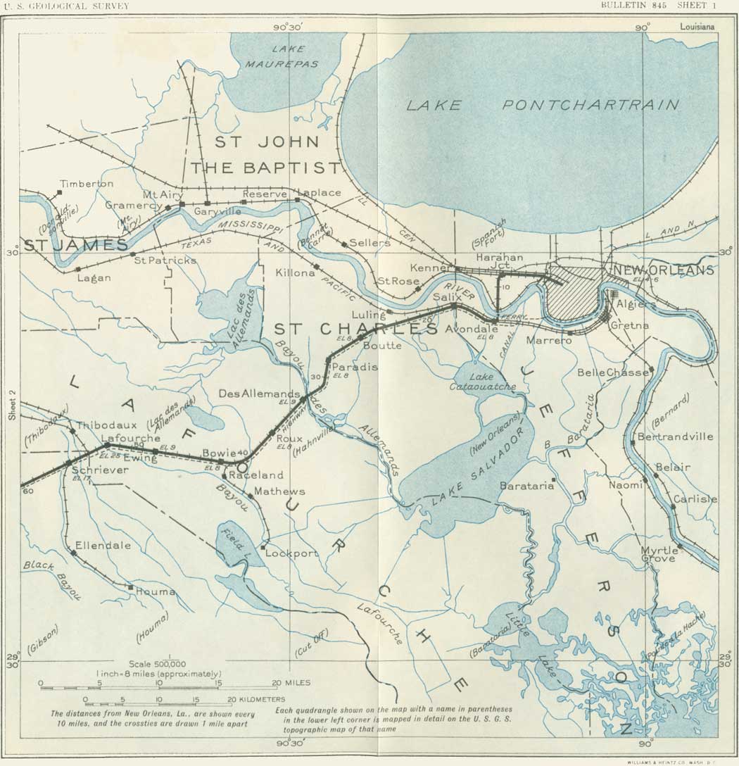
Leaving the Union Station, New Orleans, the Southern Pacific train uses the tracks of the Illinois Central Railroad as far as Harahan Junction, a switch station on the north side of the Mississippi River. (Turn to sheet 1.) Thence the line crosses the river flat in a southerly direction and in 2 miles reaches the levee, over which it passes on an incline. Here on the bank of the Mississippi the entire train, divided in sections, is placed on a huge steel barge (The Mastodon) to be ferried9 across the swift current to Avondale, on the southwest bank, a distance of nearly a mile. The floats are adjustable for different stages of the river, for there is considerable variation in the water level consequent on floods and droughts.
9This ferry is regarded as a temporary expedient, as a $20,000,000 bridge is projected.
|
|
SHEET No. 1 (click in image for an enlargement in a new window) |
The Mississippi River, flowing past New Orleans to its great delta in the Gulf of Mexico, is the largest river in North America.10 It has a drainage area of 1,231,492 square miles, and it flows across nearly the entire width of the United States.
10It is estimated by the Mississippi River Commission that the Mississippi River carries annually 500,000,000 tons of sediment. The average flow at New Orleans is from 135,000 to 1,360,000 cubic feet a second. There is a mean flow of 800,000 cubic feet a second at Old River, 130 miles above New Orleans, equivalent to a total annual discharge of 25,228,800,000,000 cubic feet.
|
Avondale. Elevation 8 feet. New Orleans 13 miles. |
At Avondale, not far south of the ferry, the train reaches the Southern Pacific tracks coming from Algiers, the terminal on the south side of the river opposite New Orleans, used only for freight. The land is low behind the levee, and most of it is too swampy for economical cultivation. In this area will be noted many cypress trees, water hyacinths, and other plants typical of the swamps and lowlands of the South. In wet places there are scattered palmettoes with their clusters of fan-shaped leaves. Most of the larger trees are festooned with the parasitic Spanish moss. A typical view in this region is given in Plate 4, A.
|
Des Allemands. Elevation 9 feet. Population 400.* New Orleans 33 miles. |
To the small local settlement at Boutte the railroad proceeds along the natural embankment of the river and then follows a low ridge through the woodlands to Des Allemands, where Bayou des Allemands is crossed. This name is derived from a small settlement of Germans founded in colonial days, but the population now consists mostly of people of French origin living in primitive dwellings along the water's edge. For many years there was a sawmill here which cut cypress lumber from the adjoining swamp lands; now the supply of this material is practically exhausted, and the main resources are fishing, crabbing, and the trapping of muskrat and other fur-bearing animals.
In midsummer the water bodies in this region are spangled with a beautiful growth of the purple flowers of the water hyacinth. Bayou des Allemands empties into Barataria Bay, an inlet of the Gulf of Mexico, which was at one time the headquarters of the pirate Jean Lafette.11 Formerly some of the district about Des Allemands was reclaimed for agriculture by ditching and pumping. Now the first signs of extensive cultivation begin near Raceland Junction, where there are fields of cane supplying the large sugar refinery at Raceland, a short distance south. This refinery, which presses about 150,000 tons of cane a season, draws part of its supply from more distant sources, some of it brought down the near-by Bayou Lafourche in barges. An interesting industrial development in the sugar industry in Louisiana is the utilization of the cane residue (bagasse) after the sugar-bearing juice has been pressed out. This material compressed into bales is shipped from many refineries to a large factory at Gretna, across the river from New Orleans, where it is pressed into sheets of building board known as celotex. In some of the cane fields at Raceland experiments are in progress to ascertain the results of using Chilean nitrates as fertilizer. Bowie siding is in the midst of cane fields, and there is a sugar refinery not far south of it.
11This notorious person, about whom center hundreds of colorful legends of this region, ran a blacksmith shop in New Orleans in the early days of the nineteenth century (at 810 Chartres Street, just off Canal Street). At this time privateersmen in the Caribbean Sea were preying upon the vessels of countries that were hostile to the countries that hired them, and Lafitte became the agent through whom they disposed of the captured cargoes. In time he became the leader of a fleet of licensed privateersmen and established a fortified post on Barataria Bay. He trafficked extensively in slaves, at one time selling 450 negroes at public auction. The proceeds of these sales and his piratical booty buried for safe-keeping are still the object of treasure hunts in the bayou country. For his loyalty to the American forces in the War of 1812, his earlier outlawry was overlooked. He resumed his piracy in 1817 and moved his headquarters from Barataria Bay to Galveston Bay, where his fortifications continued until he was driven out in 1821. Apparently he was finally lost at sea.
The abrupt change in agricultural conditions at Raceland is due to the presence of a ridge of alluvium built up by sediments spread by the overflow of Bayou Lafourche. Alluvial uplands of this character are of great economic importance in many parts of the great valley of the Mississippi, for although not wide they have rich soils and are sufficiently high to afford good drainage, roadways, and places for settlement. On them are the principal farm lands in this part of Louisiana. The mound of Bayou Lafourche extends from the Mississippi River at Donaldsonville nearly to the Gulf of Mexico, a length of more than 100 miles. Its height for most of the distance is only about 15 feet, and its width is from 3 to 4 miles.
Bayou Lafourche is the narrow stream crossed by the railroad just beyond Lafourche station. Originally this bayou was an outlet for part of the flow of the Mississippi River and was extensively utilized by freight boats, but to avoid the floods that occasionally came down the bayou, the connection at Donaldsonville was dammed off in 1903, and the navigability of Bayou Lafourche was greatly reduced. However, it is still used for traffic into the Mississippi River, with which it is connected by locks, and part of its lower course will be followed by the Intracoastal Waterway now projected across the lowlands, some distance south of the Southern Pacific lines.
|
Lafourche. Elevation 25 feet. Population 60.* New Orleans 53 miles. Schriever. Elevation 17 feet. Population 50.* New Orleans 56 miles. |
Three miles northwest of Lafourche Crossing, but not visible from the railroad, is the town of Thibodaux (population 4,400), an old village of French origin, with important agricultural and commercial interests.
An alluvial ridge extends southward along Bayou Terrebonne through Schriever, and another, extending along Black Bayou, is followed by a branch railroad to Houma. At this old town there is a large sugar refinery and an extensive business in oysters and other gulf products. Much sugarcane is raised in this part of Louisiana, and formerly there were many small sugar refineries, some of which are still visible. Potatoes have lately become an important product, and considerable corn is raised. Between the alluvial ridges the land is low and swampy, but in places it can be drained by pumping; one notable reclaimed area of this kind southwest of Raceland is yielding large crops of corn. In the swamps cypress, tupelo gum, and other trees flourish. Lumbering has long been an active industry, but many years of vigorous lumbering has greatly reduced the amount of timber available. There was formerly a sawmill at Chacaholua, and at Donner a large mill is in operation on logs brought by rail and in "booms" rafted through the great system of waterways traversing the lowlands to the north. (Turn to sheet 2.)
| <<< Previous | <<< Contents >>> | Next >>> |
bul/845/sec1.htm
Last Updated: 16-Apr-2007