
|
Geological Survey Bulletin 845
Guidebook of the Western United States: Part F. Southern Pacific Lines |
ITINERARY
|
|
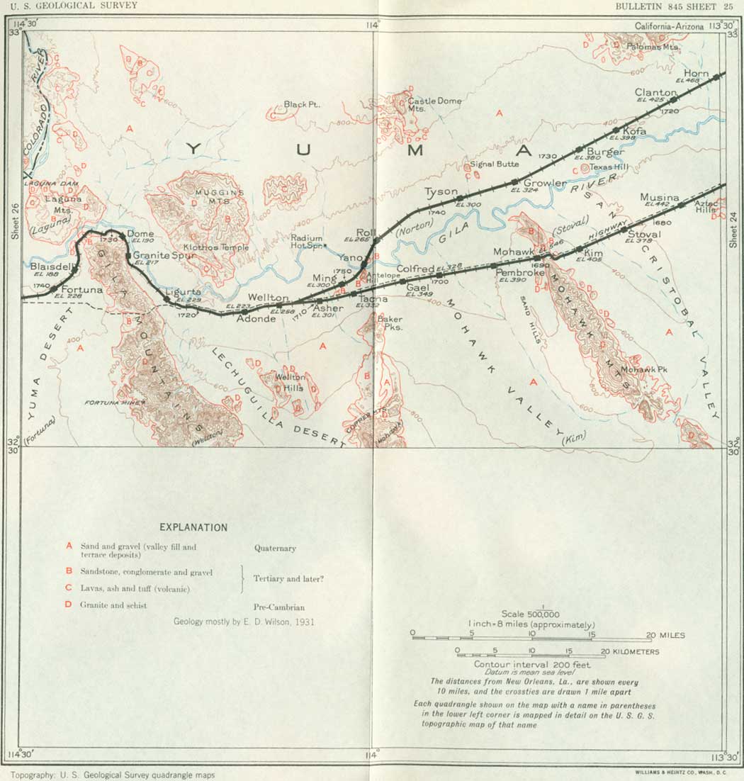
SHEET No. 25 (click in image for an enlargement in a new window) |
WELLTON TO YUMA, ARIZ.
|
Wellton. Elevation 258 feet. Population 80.* New Orleans 1,713 miles (via Phoenix, 1,756 miles). |
In the vicinity of Wellton small areas are irrigated by water pumped from wells that draw their supply from the ground water of the Gila Valley. A 1,120-foot boring at Wellton passed through 750 feet of sand and clay, regarded as valley fill, and 370 feet of harder strata, including sandstone, which probably are Tertiary. About 6 miles south of the station are the Wellton Hills, a group of small knobs and ridges consisting of mica schist with minor amounts of granite, all of pre-Cambrian age. They are in the midst of the Lechuguilla Desert (lay-choo-ghee'yah), a broad, flat valley extending south into Mexico, the international boundary being about 40 miles south of Wellton. Near the international boundary are the Tinajas Altas, rock tanks containing water. They were a famous stopping place on the Camino del Diablo (highway of the devil), a cross-country thoroughfare much used in early days and so called because of the difficulties of travel and the lack of water, which caused many deaths. This road crossed the Gila Mountains 18 miles south of Wellton and passed near the Fortuna mine on the way to Yuma, a hard journey across the loose sands of the Yuma Desert. The Gila Valley route followed by Garcés encountered west of Wellton an area subject to inundation from the river. Much later stage-coach travel stopped at a place called "Mission Station," near Adonde (ah-dohn'day), a few miles west of Wellton.
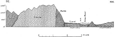
West from Wellton the railroad passes through the sidings of Adonde and Ligurta and, following the south bank of the Gila River, enters the wide gap by which that stream passes around the north end of the Gila Mountains, a very characteristic desert range that consists of granite and schist of pre-Cambrian age and that doubtless is, in part at least, a fault block. A short distance north of Ligurta fossil bones found in the alluvial deposits of the river indicate the presence of not only an ancient variety of deer but also of the native horse, which became extinct in this country thousands of years before horses were introduced by the Spaniards, a few centuries ago. To the north is a fine view of Klotho's Temple, in the Muggins Mountains, which consists of volcanic rocks. At Granite siding the railroad reaches the rocks of the mountain slope, and granite is well exposed in cuts and a quarry. From the quarry a large amount of crushed rock is produced for railroad ballast on many miles of the Southern Pacific lines. A thin mass of marble exposed in the north end of the Gila Mountains has been quarried to some extent for building. Portions of it are nearly pure calcium carbonate. The relations of the rocks in this region are shown in Figure 61. The granite is cut by many dikes of dark intrusive rocks and traversed by veins of light-colored pegmatite. To the north is the Gila River, now so well controlled by dams that it no longer is subject to the devastating floods which it formerly carried.
|
| FIGURE 61.—Section of north end of Gila Mountains, Ariz. By E. D. Wilson. |
|
Dome. Elevation 190 feet. Population 30.* New Orleans 1,729 miles. |
The long deflection of the railroad in following the river around the north end of the Gila Mountains is avoided by the highway, which goes through a high pass nearly due west of Wellton. Dome is a small place, but Gila City, its predecessor, was a turbulent boom town with a population of perhaps 1,000 people when placer mining was in progress in 1858 and a few following years.
From Dome the railroad passes through Blaisdell, Fortuna, and Araby sidings. To the east are fine views of the steep western front of the Gila Mountains. Twelve miles southeast of Fortuna siding is the old Fortuna mine, which at one time produced considerable rich ore, aggregating, it is reported, $3,000,000 worth of gold (Yearbook of Arizona, 1930). The rocks at this place are mostly hornblende schist, and the gold occurred in included quartzose members. The very pronounced schistosity dips to the south and west at an angle of 45°. Feldspathic dikes cutting the schists appear to be branches of the great intrusive masses of granite that form the higher peaks.
After passing the north end of the Gila Mountains west of Dome the railroad bends to the south and in about 6 miles reaches Blaisdell siding. In this bend the railroad follows the south bank of the Gila River. To the north are good views of the eastern part of the Laguna Mountains, which consist of schist similar to the rock on the north end of the Gila Mountains—in fact, the river gorge is simply a gateway eroded across this mass of schist. The western part of the Laguna Mountains consists of a thick body of conglomerate and boulders, probably of Tertiary age. It is separated from the schist by beds of arkose and shales, which crop out on the north side of the river and are also well exposed in slopes and cuts 2 to 3 miles north of Blaisdell. The beds dip 20° SE. and are overlain by terrace gravel of Quaternary age. The arkose is yellow and reddish and made up of granite detritus, in part thin bedded and showing mud cracks on some of its surfaces. Some of the pebbles are half an inch in diameter. A few interbedded strata of shale are of yellowish tint. These beds are probably of Tertiary age. A few sahuaros are present, this vicinity being about the western margin of their wide zone of distribution.
Southwest of Blaisdell siding the railroad leaves the wide trench excavated by the Gila River and ascends about 100 feet to the terrace plain of the Yuma Desert, which extends far to the south and southwest. It continues on this plain to Yuma. From the vicinity of Fortuna and Araby sidings Pinnacle Rock, far to the west in California, is in sight. A large gold mine was formerly operated near this peak. The vegetation on the Yuma Desert is very scant; on the alluvial flat along the river, however, there is considerable irrigation by water pumped from wells of moderate depth in the gravel and sand deposits. (Turn to sheet 26.)
| <<< Previous | <<< Contents >>> | Next >>> |
bul/845/sec25.htm
Last Updated: 16-Apr-2007