
|
Geological Survey Bulletin 845
Guidebook of the Western United States: Part F. Southern Pacific Lines |
ITINERARY
|
|
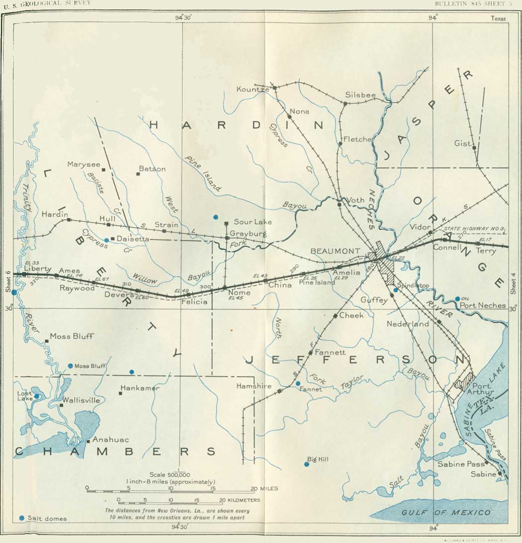
SHEET No. 5 (click in image for an enlargement in a new window) |
In the lowlands west of Orange the southern margin of the great pine belt of southern Texas is crossed, and though there are many small farms of various crops, not much land is under cultivation. Cow Bayou, a tributary of the Sabine River, is crossed about 8 miles west of Orange.
Small mounds are noticeable here and there west of Orange, most of them from 3 to 5 feet high and a few yards in diameter. They are "pimple mounds," similar to those mentioned on page 29. Six miles southwest of Orange is a group of derricks of the Orange oil field. This field, discovered in 1913, has had 416 borings, but at the end of 1930 only 86 wells were in operation, with a total yearly production of 790,000 barrels. The total production of the field to the end of 1930 was 27,716,594 barrels.31 Some of the borings are 6,000 feet deep. No salt has been encountered. Another small field at Bessie Heights, some distance farther southwest, has a few deep wells and so far only a moderate supply of oil.
31These figures and some other totals for the other oil fields in Texas are taken from Texas Gulf Coast Oil Scouts Assoc. Bull. 1, 1930. The yearly figures are those published by the U. S. Bureau of Mines.
This is a region of wide level prairies with scattered clumps of pines and a few swamp areas of small extent. Just before reaching Beaumont the railroad crosses the Neches River (nay'chase), one of the moderately large streams of eastern Texas. Near Beaumont a swamp extends along its east side. In 1834 fair-sized steamboats were navigating the Neches, Trinity, and Brazos Rivers, with smaller boats using the lesser streams.
|
Beaumont. Elevation 22 feet. Population 57,732. New Orleans 279 miles. |
Beaumont is an important commercial center for eastern Texas, and its prosperity is indicated by the fact that its population increased 40 per cent in the decade from 1920 to 1930. From Beaumont to its mouth the Neches River has been dredged out as a ship canal (opened-in 1917), 26 feet deep and 150 feet wide, capable of carrying vessels of as much as 15,000 tons dead weight, and it serves as an avenue for commerce, which in 1930 aggregated nearly 12,000,000 tons. The canal reaches Sabine Lake, 17 miles southeast of Beaumont, and, passing along the east shore of that water body, finds outlet through Sabine Pass into the Gulf of Mexico, a distance of about 35 miles. Sabine Lake and Sabine Pass are the drowned valleys of the Neches and Sabine Rivers, a condition doubtless resulting from subsidence in Recent geologic time. A large basin excavated at the head of the ship canal serves as harbor and turning basin. According to the chamber of commerce at Beaumont, the value of exports from Beaumont through the canal was $75,000,000 in 1929, and more than 600 ocean-going ships, about half of them oil tankers, call annually. It is expected that the Intracoastal Waterway will soon be completed to connect with the ship canal at Port Arthur (population 50,902), 20 miles southeast of Beaumont. At Port Arthur is one of the largest oil refineries in the world, covering 4,100 acres, with several smaller ones and a large asphalt factory.
Originally Beaumont was developed by its large lumber industry, and even before oil was discovered near by it had a population in excess of 9,000. Its sawmills utilized the yellow pine from the forests to the north; these have been largely cut off, but will in time be in part reforested. At present there is a lull in the lumber business in this region, but there remain in the adjoining districts of western Louisiana and southeastern Texas large amounts of hardwood timber, comprising red and black gum, tupelo, and oaks of various kinds, that will eventually be utilized. Hardwoods are also imported cheaply from the Tropics. Many manufacturing plants have been established at Beaumont, notably the Magnolia Petroleum Co.'s plant and the Petroleum Iron Works. There are four rice mills and a large package rice plant, for Beaumont handles much of the rice of the adjoining country, which produces 2,000,000 bushels annually. Much cotton is exported, and sulphuric acid and paint are produced. Many railroads converge at Beaumont.
The great assemblage of oil tanks about Beaumont indicates that its principal interest at present is petroleum. It is stated that these tanks have a capacity of 70,000,000 barrels. There are in this vicinity 20 pipe lines bringing oil to great refineries that produce about 10 per cent of the oil products distilled in the United States. Their capacity is 266,000 barrels a day.
The famous Spindletop oil field is at Guffey station, 4 miles southeast of Beaumont, and the derricks are visible from the train. This field is a monument to the vision and persistence of F. A. Lucas, who discovered it and led the way to the discovery of many more fields of somewhat similar salt-dome structure, several of which have been described on previous pages. Gas and other indications of oil had been noted at Spindletop for a long time, and a small supply of gas was found in a well drilled in 1893. Early in 1901 Mr. Lucas "brought in" the gusher at a depth of 1,139 feet, of which the flow was 75,000 barrels or more a day, throwing a 6-inch stream of oil 200 feet in the air. In 1902 there were 1,200 wells with a production of 17,420,429 barrels. The yield declined to about 500,000 barrels in 1925; then, with the discovery of deeper sand, rose to nearly 21,000,000 barrels in 1927. The yield in 1930 was somewhat more than 6,000,000 barrels. The total production from 1901 to 1930 has been estimated at 115,163,000 barrels from an area of 265 acres. Some of the wells yielding the later production from the deeper sand are as much as 5,800 feet deep. The Spindletop mound is underlain by a salt core a mile in diameter with an anhydrite-gypsum cap, and the older sedimentary beds dip away steeply on all sides. The depth to the salt is 1,200 to 1,600 feet in greater part. (Fenneman; Barton and Paxton.) The relations are shown in Figure 3. The name is derived from a clump of timber near by which resembled an inverted spindle top.

|
| FIGURE 3.—Section through spindletop salt dome, Texas. Partly after Fenneman |
West of Beaumont the railroad passes over a smooth plain which has a nearly regular rise from an elevation of 29 feet at Amelia siding to 77 feet on the east rim of the Trinity Valley west of Ames siding. The geologic formation is clay and sandy clay (Beaumont), which is exposed at intervals in shallow road cuts and stream trenches. There are many wide prairies, with scattered woodlands, mostly of yellow pine and oak, and numerous plantations, some of them about Amelia devoted to fig raising. Rice fields occupy large areas, and ditches for water for their irrigation are crossed by the railroad at intervals.
|
Nome. Elevation 45 feet. Population 150.* New Orleans 299 miles. Devers. Elevation 60 feet. Population 250.* New Orleans 309 miles. |
From China to Nome the configuration of the alluvial deposits marks a wide old stream bed believed to have been the channel of the Trinity River in Pleistocene time. (Barton.) From Nome to Raywood, a distance of 22 miles, there are many ridges composed of sand deposited by streams which formerly crossed the region.
Seven miles south of Devers is the Hankamer oil field in a dome discovered in 1929 by torsion-balance exploration. It yielded 546,000 barrels in 1930 from 13 wells. At Devers the railroad crosses the pipe line of the Pure Oil Co., one of the many pipe lines which convey petroleum from the oil fields to the refineries at Port Arthur.
|
Liberty. Elevation 33 feet. Population 2,187. New Orleans 321 miles. |
Liberty, founded in 1831, is in the wide valley of the Trinity River, one of the great rivers of Texas, which rises west of Fort Worth and flows into Galveston Bay 20 miles below Liberty. This valley extends nearly to Dayton, where there is a steep rise to the ordinary prairie level. The swamp occupying part of the valley shows some cypress and gum trees with Spanish moss.
Three miles below Liberty on the Trinity River is the South Liberty salt dome and oil field. The salt here comes within 500 feet of the surface and has a thick capping of gypsum and anhydrite, topped by a thin body of limestone. Its area is more than 2 square miles, and the volume of salt is very great, for it has been penetrated 2,100 feet. The field, discovered in 1905, was not productive at first, but several holes finally obtained satisfactory supplies of oil. The production in 1930 was 1,503,000 barrels, and the total yield is estimated at 12,651,800 barrels. Some of the deeper wells penetrated to the Oligocene(?) beds, which are believed to underlie the Coastal Plain at a depth of about 2,900 feet.
Near Liberty was the "Champ d'Asile," where 120 French colonists who had moved from an unsatisfactory settlement in Alabama established themselves on Spanish soil in 1818. They were soon ousted by the authorities and retired to Galveston. (Turn to sheet 6.)
| <<< Previous | <<< Contents >>> | Next >>> |
bul/845/sec5.htm
Last Updated: 16-Apr-2007