
|
Geological Survey Professional Paper 17
Preliminary Report on the Geology and Water Resources of Nebraska West of the One Hundred and Third Meridian |
SPRINGS
Several of the water-bearing formations reach the surface along the valley slopes, where their outcrop is marked by the presence of springs. The locations of the greater number of these springs are shown in Pl. XXXVII. The Arikaree formation in the high area north of the valley of Platte River supplies numerous springs, notably along the northern front of Pine Ridge. The basal beds of the Ogalalla formation also yield springs in the canyons south of the valley of Pumpkinseed Creek and along both sides of the valley of Lodgepole Creek. The most extensive series of springs is along the north front of Pine Ridge, at the base of the Arikaree formation and from the underlying Gering sands. All of the larger canyons contain springs of considerable volume, often at a succession of levels. Sowbelly Canyon is particularly favored in this respect, but the other valleys, from Jim Creek to Chadron Creek, also have good water supplies from these sources. Even on Round Top there is a fine spring just above the top of the Brule clay badlands. In the Brule clay area springs are rare and the volume of water is small. In the underlying Chadron beds there is more or less water at all points, which gives rise to seeps and springs along the outcrop zone of these beds north of Pine Ridge. In the Pierre shale region, next northward, springs are rare, superficial in origin, small in volume, and usually highly mineralized with iron, gypsum, or alkalies.
Along the Niobrara Valley there are occasional springs, mainly in the immediate vicinity of the river. Whistle Creek practically heads in Coyote Springs, at an altitude of 4,520 feet, in the center of T. 27, R. 53. The more important springs along the northern side of the valley of Platte River are East Spring, Spottedtail Spring, Wind Spring, Winter Spring, the springs near the head of Sheep Creek, and those at the headwaters of Red Willow and Indian creeks. They are derived from the lower portions of the Arikaree formation, except the Spottedtail and Winter springs, which emerge from alluvium in valley bottoms.
In the ridge between Platte River and Pumpkinseed Creek there are numerous small springs at the heads of some of the larger canyons which yield excellent water. Their distribution is shown in Pl. XXXVII. The water is derived mainly from the Gering sands at their contact with the Brule clay.

|
| PLATE XXXVII.—MAP SHOWING DISTRIBUTION OF UNDERGROUND WATERS IN NEBRASKA WEST OF THE 103D MERIDIAN. (click on image for a PDF version) |
|
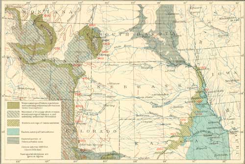
| PLATE XXXVIII.—CONTOUR MAP OF UPPER MISSOURI RIVER REGION SHOWING FACTORS BEARING ON PROSPECTS FOR DEEP UNDERGROUND WATERS. (click on image for a PDF version) |
The Pumpkinseed Valley is excavated entirely in the Brule clay, and its lower springs are derived from the alluvial deposits in the valley. This is also the case with springs on Willow Creek and Middle Creek. In the canyons along the north front of the high table-land south of Pumpkinseed Creek there are numerous springs, which yield moderate amounts of water, mainly from the base of the Arikaree formation, and, where this deposit is absent, from the base of the Ogalalla formation. These springs are known as Gabe Spring and Long Spring southwest of Harrisburg and Duggers Spring south of Courthouse Rock.
There are a number of springs along the valley of Lawrence Fork, notably one 2 miles south of Redington, which yields a large flow of excellent water. This flow, however, sinks east of Redington and reaches Pumpkinseed Creek underground.
In Lodgepole Valley springs are very rare except at points where the creek itself, having sunk into the alluvial materials in the bottom of the valley, comes out again to flow on the surface for some distance. The best-known spring of this creek is at the "Spring farm," just east of Bronson. Two small springs in Sidney Draw furnish a moderate amount of water.
The springs in this region generally occur under two conditions, which are illustrated in fig. 23. On the left-hand side of the section there is shown the typical spring flowing out of sands, A, at their surface outcrop in a canyon or at the base of high lands. The water gathers from rainfall at a greater or less distance away and sinks underground into permeable beds, through which it travels to emerge as a spring at lower levels. There are many cases, particularly in arid and semiarid regions, where the volume of a rivulet or stream is so small that after running over the surface for some distance the water will sink into the coarse materials which usually lie in the bottom of a valley, as at B. It may then continue as an underflow and emerge in places as a spring of the type shown at C, in the middle of the section in fig. 23. This occurs frequently in the region, and is the nature of some of the low-level springs above described.

|
| FIG. 23.—Ideal section to illustrate some characteristic features of springs in western Nebraska. |
|
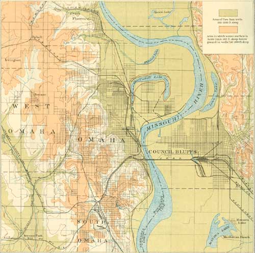
| PLATE XXXIX.—CONTOUR MAP OF OMAHA AND VICINITY SHOWING RELATIONS OF ARTESION WATER. (click on image for a PDF version) |
| <<< Previous | <<< Contents >>> | Next >>> |
pp/17/sec4.htm
Last Updated: 24-Aug-2009