
|
Geological Survey Professional Paper 296
Geology of Glacier National Park And the Flathead Region, Northwestern Montana |
GENERAL GEOLOGY (continued)
STRATIGRAPHY (continued)
PALEOZOIC STRATA
BASIS FOR DIVISIONS USED
Exposures of Paleozoic strata are confined almost entirely to areas in the eastern part of the mountains of the Flathead region. The rocks in these areas consist of marine deposits of Cambrian, Devonian, and Carboniferous age that are northward extensions of units described and named by C. F. Deiss (1933, 1943b, p. 1129-1136, 1943a, p. 216-231). His nomenclature for Paleozoic strata in and west of the Saypo quadrangle is applicable in a general way to those of the Flathead region. Lateral changes appear to exist, but more intensive paleontologic and stratigraphic work are required before these can be evaluated. In any case, they could not be adequately shown on small scale maps such as accompany the present report. Most of the names of Paleozoic formations used by Deiss are his own. The problems of correlation between these formations and those that have long been recognized farther south in Montana await further investigation.
Deiss recognized formations of Middle and Late Cambrian age in and near the Silvertip quadrangle and nine formations of similar age and character in the southern part of the Saypo quadrangle. Although the Cambrian rocks are shown undifferentiated on plate 2 of the present report, such data as were obtained as to the different formations are summarized below. It would be difficult to show the individual formations on a map of the scale of plate 2 even if sufficient data were obtained to permit their identification.
Deiss (1933) named several subdivisions of the Devonian rocks which he regarded as members of the Jefferson limestone, but in his later papers on the Saypo quadrangle, he spoke only of two units of Late Devonian age for which available data were insufficient on which to base formal names.
L. L. Sloss and W. M. Laird (1945, 1946, 1947) speak of three Devonian units. Both their reports and those of Deiss that deal with Saypo quadrangle indicate that such names as Three Forks shale and Jefferson limestone, so familiar farther south, are not at present applicable in the part of Montana under discussion. The present studies have added some facts as to exposures beyond those they covered, but the studies have otherwise contributed little to the data on the Paleozoic rocks assembled by Deiss and by Sloss and Laird.
Paleozoic strata south of the Flathead region
[Adapted from C. F. Deiss (1933-1943a, b)]
| Southwestern Saypo quadrangle | Central Saypo quadrangle | Pentagon Mountain in Silvertip quadrangle in unsurveyed Secs. 18, 13, 14, 23, 24, T. 25 N., Rs. 11 and 12W. | Spotted Bear Mountain in Silvertip quadrangle Secs. 23, 25, T. 25 N., R. 15 W. | |
| Mississippian | Hannan limestone: Basal limestone breccia overlain by gray limestone and alternating units of shaly-bedded argillaceous limestone which grades upward into hard tan-gray and pale-gray crystalline fossiliferous limestone: contains much pale-gray chert in nodules and beds as much as 7 in. thick. Upper 200 ft consists of white-gray finely crystalline thin- and thick-bedded dolomite. 1,370 ft thick. | Hannan limestone: Basal limestone breccia overlain by 400 ft of black and tan brittle limestone. Medial 600-700 ft light-gray fossiliferous cherty crystalline limestone. Upper 300 ft buff and light-gray dense thin- and thick-bedded finely crystalline dolomite which weathers white-gray. 1,460-1,500 ft thick, | Hannan limestone: Upper part of formation absent. Rooney member rather coarse-grained and thick-bedded gray limestone, 550 ft thick. Dean Lake member, blue-gray, gray, and black limestone with chert. 60 ft thick. Saypo member, chocolate and gray limestone, shaly at top and bottom. 141 ft thick. Silvertip member, breccia-conglomerate composed of gray argillaceous limestone 40 ft thick. Total exposed 791 ft. | Hannan limestone: Upper part of formation absent. Rooney member, chocolate and gray thin, bedded argillaceous limestone with coarse-gained white thick- and thin-bedded limestone at base. 177 ft thick. Saypo member, gray, white, and pink limestone interbedded with buff and red calcareous sandstone with chocolate limestone below. 220 ft thick. Silvertip member, gray-white breccia conglomerate. 23 ft thick. Total exposed 420 ft. |
| Unconformity | ||||
| Devonian | Dolomitic limestone and shale overlain by tan-gray fine- to medium-gained fossiliferous limestone. Alternate units of drab-brown petroliferous arenaceous thick-bedded dolomite and light-gray hard finely crystalline thick- and thin-bedded limestone. All more or less petroliferous and argillaceous. 980 ft thick. | Dolomitic limestone and shale overlain by tan-gray fine- to medium-gained fossiliferous limestone. Alternate units of drab-brown, petroliferous, arenaceous thick-bedded dolomite and light-gray hard finely crystalline thick- and thin-bedded limestone. All more or less petroliferous and argillaceous. 1,000 ft thick. | Spotted Bear member, thin-bedded limestone at top and bottom. Massive tan and brown limestone in main part. A little shaly. 282 ft thick. Lone Butte member, drab-brown petroliferous limestone at top. Red-chocolate and brown petroliferous limestone, locally shaly. Thickness 220 ft. Coopers Lake member, thick- and thin-bedded chocolate, tan and gray limestone. 263 ft thick. Total thickness 844 ft. | Spotted Bear member, gray thin-bedded partly argillaceous limestone at top and bottom. Thicker bedded gray, tan, and pink limestone in middle part. Thickness 287 ft. Lone Butte member, massive chocolate and blue-gray limestone with clay bands and nodules. 185 ft thick. Coopers Lake member, gray and tan limestone partly siliceous. 298 ft thick. Glen Creek member, dull red shale. 40 ft thick. White Ridge member, tan-gray limestone flecked with pink. 50 ft thick. Total thickness 860 ft. |
| Unconformity | ||||
| Upper Cambrian | Devils Glen dolomite: White-gray to pale-buff-gray finely crystalline thick- and thin-bedded dolomite. Mottled salmon pink and coarse gained in upper part of formation. Weathers white gray and forms shear cliffs. 198-250 ft thick, | Devils Glen dolomite: White-gray to pale-buff-gray finely crystalline thick- and thin-bedded dolomite. Mottled salmon pink and coarse gained in upper part of formation. Weathers white gray, and forms shear cliffs. 200-260 ft thick. | Devils Glen dolomite: Thick-bedded buff siliceous dolomite with a bed of sandy dolomite below and one of red-pink calcareous argillaceous sandstone at base. 43 ft thick. | Devils Glen formation: Thick-bedded white and cream-gray massive dolomite. 460 ft thick. |
| Middle Cambrian | Switchback shale: Green and gray soft shale; locally calcareous and arenaceous; interbedded with flaggy-bedded magnesian limestone which weathers rusty tan. 75-125 ft thick. | Switchback shale: Green and gray soft shale; locally calcareous and arenaceous; interbedded with flaggy magnesian limestone which weathers rusty tan. Contains youngest known Middle Cambrian trilobites and others which belong to basal upper Cambrian (Cedaris) fauna. 125-175 ft (?) thick. | Switchback formation (type locality): Mostly thick- and thin-bedded cream-gray massive argillaceous limestone with green-gray shale and shaly limestone at base. 106 ft thick. | Switchback formation: Brown calcareous and shaly sandstone underlain by cream-gray limestone. 70 ft thick. |
| Steamboat limestone: Pale-gray and tan fine-grained thick- and thin-bedded limestone overlain by interbedded tan-gray irregularly bedded fossiliferous limestone and green fissile shale. Shale in units 2-8 ft thick separated by much thicker units of limestone. 275 ft thick. | Steamboat limestone: Pale-gray and tan fine-grained thick- and thin-bedded limestone overlain by interbedded tan-gray irregularly bedded fossiliferous limestone and green fissile shale. Shale in units 2-8 ft thick separated by much thicker units of limestone. Base of formation not exposed. 275 ft thick | Gordon Mountain formation (type locality): Chocolate, tan, and gray mostly thick-bedded limestone, argillaceous near top and with clay and shale at several horizons. 216 ft thick. | Gordon Mountain formation: Buff brown argillaceous limestone. 368 ft thick. | |
| Pentagon shale: Buff-gray platy calcareous thick-bedded fossiliferous shale, which grades upward into thin- and thick-bedded limestone. 0-290 ft thick. | Absent. | Pentagon formation (type locality): Gray, tan, and chocolate limestone; mostly platy and argillaceous. Some shale. 290 ft thick. | Pentagon formation and Pagoda foration: Mostly obscured by soil and glacial drift. Interval represents 296 ft of beds. | |
| Pagoda limestone: Green fissile shale interbedded with thin-bedded limestone; overlain by cream and chocolate-gray finely crystalline limestone; thin-bedded In lower and upper parts, and oolitic and thick-bedded in middle part. 200 ft thick. | Pagoda limestone: Green fissile shale interbedded with thin-bedded limestone; overlain by cream and chocolate-gray finely crystalline limestone; thin-bedded in lower and upper parts, and oolitic and thick-bedded in middle part. Exposed thickness not known. | Pagoda formation: Massive thin and thick-bedded limestone at top with some black fissile shale, followed below by gray to black calcareous shale with thin limestone beds and, near base, limestone conglomerate with red green and gray pebbles. 290 ft thick. | ||
| Dearborn limestone: Green fissile shale and intercalated limestone conglomerate; overlain by tan-gray thick- and thin-bedded limestone which contains varying amounts of buff and orange-tan clay as flakes nodules, and partings. 300 ft thick. | Lower part of the Cambrian strata not exposed. | Steamboat formation: Gray and chocolate-gray platy limestone with buff clay. 74 ft thick. | Steamboat formation: Tan gray, and chocolate limestone with flakes of buff siliceous limestone in some beds. 91 ft thick. | |
| Dearborn formation: Thick- and thin-bedded tan and gray limestone with clay bands and nodules. Green-gray fissile shale at base. 213 ft thick. | Dearborn formation: Mostly gray and buff argillaceous limestone. Locally has bands of calcareous clay. Near base has beds of lithographic limestone. 238 ft thick. | |||
| Nannie Basin formation: Gray, tan-gray, and blue-gray limestone with flakes and nodules of buff clay. 170 ft thick. | Nannie Basin formation: Gray argillaceous limestone with bands of buff and gray clay; underlain by pink-gray limestone. 59 ft exposed. | |||
| Damnation limestone: Blue and tan-gray thin-bedded fossiliferous limestone with much limonitic clay; overlain by chocolate-gray and tan fine-grained thick- and thin-bedded hard massive limestone, which also contains flakes and blebs of buff siliceous clay. 150 ft thick. | Damnation formation: Thin-bedded shaly tan limestone with flakes and nodules of buff clay; weathers bright buff. 21 ft thick. | Strata below are faulted out. | ||
| Gordon shale: Drab-green-gray and maroon fissile to chunky micaceous shale interbedded in upper middle part with thin beds of sandstone and thicker beds of limestone. Upper beds very fossiliferous. 220 ft thick. | Wolsey formation: Sandy micaceous limestone with much green shale at top. Green-gray micaceous fissile shale, with thin sandstone and sandy limestone beds. Contains hematite oolites. 140 ft thick. | |||
| Flathead sandstone: Coarse- and fine-grained crossbedded sandstone interbedded with thin units of micaceous and areanceous shale. Most diagnostic feature is presence of white quartz pebbles 1/8-3 in. in diameter. Basal beds commonly pebbly conglomerate. 50-100 ft thick. | Flathead formation: White to cream thin- and thick-bedded quartzite, with limonite grains; underlain by red crossbedded pebbly quartzite, with pebbles up to 1-1/2 in. in diameter. 117 ft thick. | |||
Deiss grouped all of the Paleozoic rocks above the Devonian strata as the Hannan limestone of Mississippian age, a convenient designation which is adopted here. Both Deiss and Sloss and Laird in the papers just cited indicate that subdivision of the Hannan is possible. These authorities differ as to the details, and the matter has not yet been submitted to the test of areal mapping. For the kind of mapping embodied in plate 2, the formation is a convenient, easily recognized body without subdivision.
Deiss believes unconformities separate the Cambrian, Devonian, and Mississippian assemblages from each other and from the Precambrian and Mesozoic strata. As angular discordances are nowhere marked, proof of the stratigraphic breaks is furnished mainly by the fossil evidence. Within the Paleozoic sequence this evidence as presented by Deiss seems conclusive except that Sloss and Laird (1947, p. 1420-1421) raise a question as to whether there is an unconformity between the Devonian and Mississippian strata. The seemingly complete absence of Ordovician, Silurian, Permian, and Triassic rocks leaves no doubt that major breaks in the record exist. At the base of the Paleozoic succession, more uncertainty exists, in part because of the absence of diagnostic fossils. Deiss (1935, p. 95-124) has assembled much data favoring the concept of an unconformity below the Flathead quartzite. The few exposures of this horizon in the Flathead region do not give positive evidence on this point. For the purposes of the present report, this question may be left open.
Four stratigraphic sections of the Paleozoic rocks south of the Flathead region are given below, adapted from the publications by Deiss cited above. The correlations between the sections seem implied but were not made in the reports cited. A notable feature is that Deiss found it necessary to propose new names because he believes that few of the well-known formation names of southern Montana are applicable here. The members named in the sections from Pentagon and Spotted Bear Mountains are of local significance only. They have not been formally adopted by the Geological Survey.
CAMBRIAN ROCKS
The sedimentary rocks of Cambrian age are mapped as an undifferentiated unit. Wherever they are well exposed, it is obvious that formational divisions are present; but, in a country as intricately faulted as the eastern part of the Flathead region, mapping of formations would be time consuming and impracticable in many places on the scale of the present map. The following descriptions give such information as is available regarding the distribution of beds that seem to be correlatable with units farther south recognized by Deiss.
Large masses of Paleozoic rocks are exposed in the northern part of the Silvertip quadrangle (unpublished geologic map by C. F. Deiss). A small body of Cambrian strata extends from this mass across the southern border of the Flathead region into the area between the two Twin Creeks. The Flathead quartzite was not found within this body although boulders suggest that it is present a short distance to the south. The lowest beds that are present are on the lower slopes of the east side of lower Twin Creek below Tanner Creek. These beds are mainly dark-greenish micaceous shale, with some quartzite. The apparent thickness is over 500 feet, but this is undoubtedly exaggerated by crumpling and perhaps also by minor thrust faulting. Exposures are inadequate for determining structural details, but in nearby cliffs intricate deformation is well displayed. An undetermined thickness of dark-gray highly oolitic limestone with chert in its upper part overlies the shale and is succeeded upward by other limestone beds, mostly light gray but in part mottled. The blebs and flakes of clayey material that distinguish much of the Cambrian limestone of the region are nowhere conspicuous along lower Twin Creek.
The general character of the rocks just described and their relations to Paleozoic rocks in the Silvertip quadrangle and to Precambrian rocks north and east of them are all in accord with a Cambrian assignment. Presumably the shaly rocks on the lower slopes belong, at least in part, to the Wolsey formation (or shale) described by Deiss, even though the apparent thickness is great. The limestones above would then belong to formations higher in the Cambrian sequence, possibly ranging upward into the Pagoda formation. Deiss (1935, p. 37-38) describes his Pagoda formation as variable in thickness and character. In one locality the Pagoda formation, like the rocks here discussed, contains conspicuous oolitic beds.
Eastward, the next exposures of Cambrian rocks are on both flanks of the valley of Dolly Varden Creek. On the southwest slope, massive beds of limestone form steep cliffs and are overridden by beds of the Missoula group along a steep thrust fault. The upper cliffs expose white dolomite which presumably belongs to the Devil Glen dolomite. On the ridge from Gable Peaks to Cruiser Mountain, east of Dolly Varden Creek, the Cambrian beds are less disturbed, although parts of them are covered by landslide debris. The table below records observations made on and near Gable Peaks. The two lowest formations here are surely the Flathead quartzite and Wolsey shale. The Wolsey shale appears to be essentially equivalent to the formation which Deiss spoke of as the Gordon shale in the Saypo quadrangle. The Damnation limestone, which Deiss reported as only 21 feet thick a few miles to the south, was not recognized on Gable Peaks and may be absent there. It seems a reasonable assumption that the 130 feet of poorly exposed beds above the Wolsey belong to the Nannie Basin formation of Deiss, although, if so, they are more shaly than his description shows the formation to be farther south. However, shale appears to be more conspicuous throughout the Cambrian rocks on Gable Peaks than it is in the localities in which Deiss measured his sections. The other highly tentative correlations in the table below are based largely on the fact that the Pagoda formation is the only one in which Deiss reports that, locally, oolitic beds are conspicuous. No diagnostic fossils were found on or near Gable Peaks, except that Masursky found Elrathiella cf. E. plana Deiss in limestone on Cruiser Mountain some distance to the south. A. R. Palmer, who examined Harold Masursky's specimen, suggests that it may have come from a horizon high in the Pagoda or low in the Pentagon formation, which would be consistent with the tentative correlations in the table.
Both in the table below that summarizes data for Gable Peaks and in the correlation table for Cambrian rocks given above Deiss's name Nannie Basin formation (1933, p. 36) is retained for local use even though in his later papers Deiss dropped that name and included the rocks in his Dearborn limestone.
In addition to those on Cruiser Mountain, a patch of Cambrian rocks was recognized by Masursky in the fault complex north of Lodgepole Creek. The formations that are represented in that area were not identified.
Cambrian strata on and near Gable Peaks
| Approximate thickness in feet |
Character | Tentative correlation |
| Gray massive limestone with light-yellow streaks. | ||
| 230 | Buff-weathering fossiliferous limestone with thin beds of hard chocolate limestone and nearly black shale. | Pentagon formation. |
| 275 | Gray oolitic limestone in beds 1-3 ft thick. | Pagoda formation. |
| 40 | Covered. Largely greenish-black micaceous shale. | Steamboat formation. |
| 130 | Light-chocolate limestone with yellow mottlings and partings. | Dearborn formation. |
| 130 | Poorly exposed greenish micaceous and sandy shale with thin beds of oolitic limestone. | Nannie Basin formation. |
| 90 | Covered. Largely shale. | Wolsey shale. |
| 75 | Poorly exposed red and green micaceous shale. | |
| 25 | Reddish and white quartzite with beds of grit and fine conglomerate (pebbles up to an inch in diameter) crossbedded. | Flathead quartzite. |
| Total 995 | ||
Beds of Cambrian age crop out in the eastern part of the region mapped (fig. 24) in a band that extends from the North Fork of Dupuyer Creek to the vicinity of Heart Butte, a distance of roughly 14 miles. The most conspicuous and widespread unit is a limestone with numerous yellow, tan, and brown flakes of argillaceous material in it. The clayey flakes appear to be like those reported by Deiss from beds of Middle Cambrian age in several localities farther south, particularly in the Steamboat limestone. Only a few poorly preserved fossils were found, mostly by Masursky. The only collection of any diagnostic value is from the ridge north of Swift Reservoir. This collection was examined by G. Arthur Cooper and later by A. R. Palmer. It contains Solenopleurella sp. and Elrathiella cf. E. plana Deiss. Although the Solenpleurella resembles S. pagodensis Deiss, it is not, according to Palmer, identical with that species. Palmer is inclined to think that the collection may have come from the lower part of the Pagoda limestone of Deiss. In this connection it may be remarked that Deiss (1933, p. 38) in his original description of the Pentagon shale says: "It is a significant fact that the Pentagon formation is shale and shaly limestones only in the immediate vicinity of Pentagon Mountain, but that its equivalent in all of the other sections is generally massive limestone." He adds that the limestone has a small amount of clay disseminated as flakes. The quotation is modifed by the fact that later Deiss (1943a, p. 221-222) tentatively assigned some shale and limestone in the southern part of the Saypo quadrangle to the Pentagon shale. The rocks in the vicinity of Swift Reservoir are limestone, and many contain clay flakes. Shale was noted among the Cambrian rocks in only a few places in the eastern part of the Flathead region. The principal exposures recorded are green and maroon shale outcrops along Whitetail Creek west of Feather Woman Mountain and in the ridges east of Mount Richmond.
DEVONIAN ROCKS
Beds believed to be of Devonian age have been mapped in discontinuous bands from the southern border of the Heart Butte quadrangle east of the North Fork of Teton River north to Feather Woman Mountain and Heart Butte. There are smaller patches southeast of Half Dome Crag, on Spotted Eagle Mountain, Family Peak, Mount Dreyer, and in several other localities in and near the Heart Butte quadrangle, mostly near its southern boundary. Several of these scattered masses were mapped from distant vantage points on the basis of color and relations to the Hannan limestone, so that revisions are to be expected when detailed mapping is done, especially as few Devonian fossils have been found anywhere in the area. There are exposures of Devonian strata on and near Big Lodge and Tent Mountains in the Marias Pass quadrangle, but none are known farther west.
The Devonian rocks in this part of Montana have not been divided into named formations. Deiss (1943b, p. 1134-1135) reports that 1,000 feet of Upper Devonian strata are present in the central part of the Saypo quadrangle and that they can be mapped as one and locally two formations. Sloss and Laird (1945, 1946, 1947) have measured sections in and west of the Saypo quadrangle. They divide the Devonian rocks into three major subdivisions, termed "units A, B, and C," and indicate that the thickness in different localities ranges up to somewhat over 1,500 feet.
The Devonian rocks in the area described in the present paper must be broadly similar to those farther south described by Deiss and by Sloss and Laird. They are characterized by much dark limestone that weathers brownish and most of which is commonly distinctly fetid. Some beds contain blebs of different kinds, but few contain numerous yellow, tan, and brown argillaceous flakes and blebs similar to those that are so widespread and conspicuous in the Cambrian rocks. Few complete sections of Devonian rocks were seen during the present study. The data tabulated below result from two traverses made by Harold Masursky in which thickness estimates were based on aneroid barometer and Brunton clinometer readings.
Section of Devonian rocks with top about at benchmark 7540 between Phone Creek and Lucky Creek
[Calculated from Harold Masursky's notes]
| Approximate thickness in feet | |
| Limestone, gray; resembles a coquina with crinoid stems and bryozoa | 2 |
| Shale, brown, calcareous; weathers pink and buff | 2 |
| Limestone, black; brecciated and cemented with calcite veinlets | 230 |
| Limestone, black, fine-grained, thick-bedded, with some calcite veinlets | 34 |
| Limestone, dark-gray; weathers cream and tan | 17 |
| Dolomite, gray; weathers to a lighter gray | 48 |
| Limestone, black, in beds 2-5 ft thick; weathers gray | 17 |
| Shale, brown, limy | 68 |
| Limestone, gray; weathers gray | 4 |
| Limestone, brown, with corals; weathers cream | 5 |
| Limestone, gray; weathers gray | 5 |
| Limestone, black, laminated | 4 |
| Limestone brown, with calcite blebs and veinlets; has strong fetid odor | 128 |
| Limestone, gray, with calcite veinlets | 8 |
| Limestone, brown, fetid | 88 |
| Total, estimated | 660 |
| Covered below, but total thickness of supposed Devonian rocks exceeds 1,000 ft. | |
Section on the southeast flank of Feather Woman Mountain
[Calculated from Harold Masursky's field notes]
| Feet | |
| Mississippian system: | |
| Black limestone, thin-bedded; weathers gray and tan; contains chert and crinoid stems; forms cliff | 200 |
| Buff limestone, with pink and tan clayey flakes; talus covered; possibly in part shaly | 285 |
| Devonian system: | |
| Limestone, gray and buff, alternating | 70 |
| Limestone, gray | 3 |
| Limestone, buff | 17 |
| Limestone, gray, resistant | 10 |
| Limestone, buff, thin-bedded, increasingly shaly upward; weathers tan and yellow in alternating bands | 115 |
| Limestone, gray | 5 |
| Limestone, black, thin-bedded, resistant; weathers brown | 105 |
| Limestone, gray | 5 |
| Limestone, black, fetid; weathers brown with irregular white blebs | 600 |
| Total thickness of Devonian strata | 930 |
| Cambrian system: | |
| Limestone, black, thin-bedded | 25 |
| Limestone, black, massive, thick-bedded, with yellow blebs and laminae | 50 |
| Total at bottom of canyon | 1,490 |
Discrimination between the Devonian strata and those that overlie and underlie them is based primarily on lithologic characteristics, as few fossils were collected. Atrypa missouriensis was identified by G. Arthur Cooper in specimens from near Hurricane Mountain and from a small fault block on Spike Creek, a small tributary of the Middle Fork of Birch Creek. In the field the upper 268 feet of the section near Phone Creek was thought to belong to the Hannan limestone, but it seems more probable that the brecciated beds in this part of the section correspond to the breccia near the top of the Devonian sequence farther south. These breccias are reported in the papers cited above as resulting from solution of extensive anhydrite deposits. It is somewhat strange that no such breccia was recorded from the section on Feather Woman Mountain in which the Devonian rocks are overlain by beds of definitely Mississippian characteristics and that similar breccias are absent or inconspicuous in the exposures of Devonian rocks seen in other localities.
Evidently the exposed part of the section near Phone Creek corresponds essentially to the upper half of the Devonian section on Feather Woman Mountain. There are numerous differences in detail between these two sections, and similar differences exist between all recorded sections of Devonian rocks in this part of Montana. For that matter, there are differences among the various recorded sections of other Paleozoic units in the region also. These differences result in part from lateral variations in the beds. They can be evaluated and understood only after more complete and detailed geologic mapping has been accomplished.
UPPER PALEOZOIC ROCKS
The Paleozoic rocks above the Devonian rocks are here grouped as the Hannan limestone in accord with Deiss' usage (1943a, p. 227-231). This formation is of Mississippian age and, according to Deiss, is partly correlative to both the Madison and the Brazer limestones. It includes all the beds in the region under discussion which lie between the Devonian and Jurassic rocks. In the eastern part of the Flathead region, the Hannan constitutes the principal formation exposed in a band of northwesterly trend that extends from the southern border of the mapped area to Mounts Baldy and Pablo, a distance of about 28 miles (figs. 22, 23). The northeastern border of this band throughout its extent is at or near the boundary between the mountains and the plains, and the width of the band is about 10 miles. Another line of outcrops of Hannan limestone subparallel to this band and almost as long but much narrower appears immediately east of the Lewis overthrust near the middle of the region covered by plate 2.
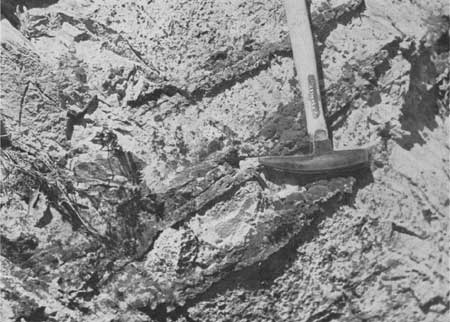
The Hannan limestone constitutes one of the most easily recognized and best exposed units in the region. It is composed of thick- and thin-bedded gray limestone, in part dolomitic. Many of the beds contain abundant chert (fig. 17). Thin beds are especially conspicuous near the base of the formation in most localities. Some of the beds throughout the formation are healed breccias. Shale is not plentiful but is reported to be abundant at some horizons in the Hannan south of the region here reported on. Fossils are fairly common, and crinoid stems and corals are the most conspicuous. Data on the fossils in the Hannan farther south are given by Deiss in the paper just cited and by Sloss and Laird (1945).
|
| FIGURE 17. Closeup of Hannan limestone with chert layers, gorge of Gateway Creek, Heart Butts quadrangle, Flathead region. |
Only a few collections from the Hannan were made during the present investigation. These were examined by James Steele Williams and Helen Duncan, of the Geological Survey, who report that the fossils are not positively diagnostic but have a Mississippian aspect and contain nothing incompatible with assignment to the Hannan limestone.
While the evidence of the fossils, taken alone, may thus not be conclusive, the field relations leave no doubt that the unit is to be correlated with the Hannan limestone of Deiss. Deiss (1943a, p. 230) gives a list of fossils collected from the Hannan limestone south of the Flathead region. The collections made during the present investigation and identified by J. S. Williams and Helen Duncan include the forms listed below:
Brachythyris? cf. B. suborbicularis (Hall)
Brachythyris? sp. indet.
Crinoid columnals
Spirifer of the S. rostellatus Hall type
Other spiriferoid shells
Rynochopora? sp. indet.
Orthoceroid cephalopod?
Fenestellid bryozoans, 2 species
Polypora sp. indet.
Rhomboporoid bryozoans, indet.
Sulcoretepora sp. indet.
Camaro toechia? sp. indet.
In the two papers by Deiss that deal with the Saypo quadrangle, the thickness of the Hannan is about 1,400 feet. The formation was not measured during the present examination, but the thickness within the area mapped is thought to be at least as great as that in the Saypo quadrangle. A few of the sections drawn by Sloss and Laird show thicknesses of Mississippian rocks in excess of 1,500 feet, but most are thinner. It seems from their sections and description that breccias are more conspicuous in the mountains west of Choteau than in any of the outcrops in the Flathead region.
| <<< Previous | <<< Contents >>> | Next >>> |
pp/296/sec2-2.htm
Last Updated: 08-Jul-2008