
|
Geological Survey Professional Paper 631
Analysis of a 24-Year Photographic Record of Nisqually Glacier, Mount Rainier National Park, Washington |
INTRODUCTION
PURPOSE AND SCOPE
Reasons for the program
Over the years, glaciers show marked changes. For their study and analysis a repetitive photographic program has obvious potential value because it is relatively quick and inexpensive and can include a wealth of information unobtainable by ordinary surveying techniques. Such a program graphically portrays the visible characteristics and changes inherent in a fluctuating glacier. Since this has long been recognized, systematic photographic programs have been undertaken on many glaciers in many parts of the world. However, no such program, to the knowledge of the writer, has combined a fairly detailed photographic coverage over nearly the full length of a single glacier, a long period of annual record, and an analysis of the potential of a program such as is described in this paper.
Published reports by Field (1932, 1937, 1947), Harrison (1954, 1956), LaChapelle (1962), Meier and Post (1962), and others have utilized glacier photographs, but the pictures for any one glacier did not include coverage or length of record as detailed as those available for Nisqually Glacier, nor did the reports indicate the many kinds of data obtainable from such photographs. Such an analysis is especially important now because a photographic record has been designated as a first, least costly step, in the new program "Measurements of Glacier Variations on a World-Wide Basis" of the Commission of Snow and Ice (International Association of Scientific Hydrology). This global-scale program is also part of the International Hydrological Decade. Thus, the findings and techniques described herein are thought to have possible application elsewhere.
The idea that worthwhile benefits might derive from a long-term program of annual photographs of Nisqually Glacier was conceived by the writer in collaboration with Arthur Johnson of the U.S. Geological Survey when Mr. Johnson was mapping the glacier in 1941.
Soon after the annual photographic records were begun, a marked thickening of the upper part of the glacier was noticed from the annual cross-profile surveys (Johnson, 1949). The thickening was followed over a period of two decades by one unusually large and several smaller kinematic (moving) waves of fresh ice advance. The effect of these was particularly impressive in the terminal area from 1963 to 1965. The waves probably resulted from the marked increases in precipitation on Mount Rainier as evidenced in the measurements at Paradise Ranger Station, situated less than a mile (1.6 km (kilometers)) from the glacier at an altitude of 5,430 feet (1,160m (meters)).
The climatic change of the late 1940's, which subsequently was found to have caused the advance of glaciers in many parts of the world, apparently was first detected in 1946 and 1947 in glaciers on Mount Rainier. As a result, Nisqually Glacier became an object of considerable international scientific interest.
A program of this kind is less expensive than one based on aerial or phototheodolite photography because it does not require trained photogrammetrists or as costly equipment. Furthermore, since it consumes relatively little field time its success is more certain during brief periods of cloudless weather.
Purpose of the report
The primary purpose of this report is to describe, and demonstrate by means of examples, what kinds of data usable in analyzing glacier characteristics can be obtained from a simple program of long-term photographic coverage from stations on the ground. It is not intended to be a detailed or complete report on the glacier's physical characteristics.
Secondary purposes of the report are to describe to interested workers the photographs available here and to illustrate some of the spectacular changes that have occurred in this glacier. Examples are given of qualitative and quantitative data sought in regard to the glacier's growth, depletion, movement, slope, moraines, crevassing, snow and firn lines, and debris cover. Some objectives that developed as the photographic program progressed were the illustration of some geomorphological changes occurring in old moraines and the adjacent hills and valley, and the portrayal of erosion and other changes in the river channel below the glacier from outburst floods and other causes.
The report presents photographs taken by the writer for 24 years from about 20 stations and some older photographs taken by others. Only a hand-held amateur camera was used, without photogrammetric instruments of any nature. Office techniques used included the interpretation and marking of ice margins and slope crest lines on photographs, and the performance of simple scaling, scale-ratio computations, and angle measurements.
Selection of study area
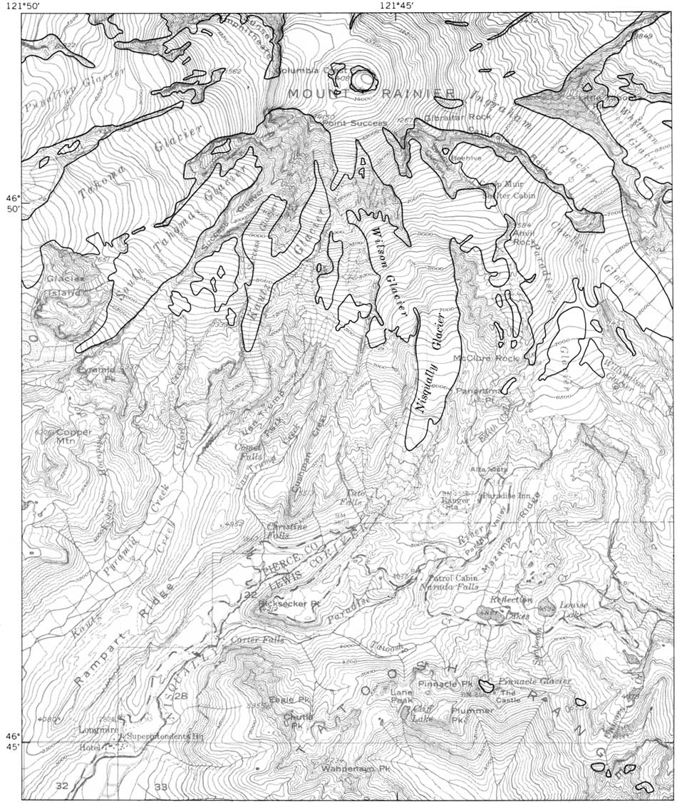
Nisqually Glacier on Mount Rainier, Wash., was chosen for the project because of its variety of features for such an experiment, the availability of data from previous investigations, the many concurrent topographical and profile survey data which could be used for checking, the superior accessibility of this glacier, and the practical local interest in it as an important source of the water supply of the Nisqually River. The general location and access to the glacier are shown in figure 1.
|
| Figure 1.—South side of Mount Rainier and vicinity, showing location of Nisqually Glacier. Glacier margins and part of culture corrected to 1966. Scale 1 inch = 62,500 feet (approximately 1 inch = 1 mile). (click on image for an enlargement in a new window) |
Quantities of melt water coming from Nisqually Glacier vary with the amounts of snow and ice it contains and with external conditions such as air temperature and the amount of radiant energy received from the sun. Streamflow records show that the discharge of the Nisqually River is markedly affected by variations in the melting rates of headwater glaciers. Thus, because the river is used for the production of power at hydroelectric plants downstream from Mount Rainier National Park, any study of glacier fluctuations and related climatic changes is of important economic interest in connection with the long-range planning of water resource use.
PREVIOUS INVESTIGATIONS
Photographs
Nisqually Glacier in Mount Rainier National Park long has been a favorite object of photographers, for it is a readily accessible subject for glacier research and is part of a high-altitude area of rare scenic grandeur. For many years (until 1936) its terminus remained less than half a mile (0.8 km) upstream from the former highway bridge on the road to Paradise Inn. The main body of Nisqually Glacier is visible from several vista points along its east side, accessible from the Paradise Inn area (pl. 1).
Numerous random photographs, mostly confined to the area of the terminus, were taken in association with surveying activities. The first known photograph of the glacier was a view of the snout taken by Allen C. Mason in 1884.
I. C. Russell (1898, p. 399-400), as a member of a U.S. Geological Survey group making a reconnaissance of Mount Rainier and its glaciers, recommended systematic photographic coverage and measurement of the position of the Nisqually Glacier terminus from permanent, marked locations. Russell also reported that Nisqually Glacier affords abundant opportunity for observation and study of the various features that glaciers possess, such as crevasses and moraines. No network of regularly scheduled photographs covering most of the glacier was established until 1942, nearly half a century later, when a program of annual photographs from about 20 stations was initiated by the writer, then district engineer, Water Resources Division, Geological Survey, Tacoma, Wash.
Surveys and maps
A definite location of the terminus of Nisqually Glacier was recorded first in 1857, by Lt. A. V. Kautz, and next in 1885, by James Longmire. Its approximate position in 1910 was determined on the small-scale planetable map of Mount Rainier National Park that was made in 1910-13 by the U.S. Geological Survey under the supervision of F. E. Matthes. Annual records of the position of the terminus, begun in 1918 by F. W. Shmoe, National Park Service, were obtained each year by that agency until 1961 and have been continued since then by the Conservation Division of the U.S. Geological Survey.
In 1930 and 1931, Llewellyn Evans, superintendent of the Light Division, Tacoma Department of Public Utilities, made cross-profile and other surveys and compared the results with data taken from Matthes' 1910 map. In 1931 a contour map was prepared cooperatively by the Tacoma [City] Light Division, the National Park Service, and the U.S. Geological Survey. A plan of contour mapping at 5-year intervals was then conceived by Llewellyn Evans, Owen A. Tomlinson, and Glenn L. Parker of those respective agencies. This has been done, beginning in 1936, first by planetable and later (covering a larger area) using photogrammetry from aerial photographs, by the U.S. Geological Survey in cooperation with the city of Tacoma and the National Park Service. At the request of the Tacoma Light Division a map of the same type was also made in 1940; it was not published but is on file in the office of the Conservation Division, U.S. Geological Survey, Tacoma, Wash.
Nisqually Glacier was also mapped by terrestrial photogrammetry in 1952 and 1956 by Walther Hofmann of the Technical Institute in Munich, Federal Republic of Germany (Hofmann, 1958).
Beginning in 1940, the Conservation Division of the U.S. Geological Survey, under the supervision of regional hydraulic engineers Arthur Johnson (to 1952), Fred A. Johnson (1953-62), and Gordon C. Giles (1963- ), has made annual surveys by stadia techniques of three cross-profiles of the glacier (locations on pl. 1). The Conservation Division also has made surveys of glacier movement and has reported on recession and volume changes (Johnson, 1960). The surveys have been carried out with the assistance and cooperation of National Park Service personnel and, in some years, with the financial assistance of the Tacoma Department of Public Utilities.
The 1956 map used for showing locations of the photographic stations and cross profiles was prepared by the Topographic Division of the U.S. Geological Survey, which obtained the topography from aerial photographs by using a Wild A—8 plotter.
ACKNOWLEDGMENTS
This report was prepared under the general supervision of Mark F. Meier, geologist in charge of glacier research. The assistance of Austin Post and Donald Richardson was very helpful. Collaboration of several colleague reviewers, especially Arthur Johnson and Gordon C. Giles of the U.S. Geological Survey and W. O. Field of the American Geographical Society, is gratefully acknowledged. The Tacoma Department of Public Utilities furnished several photographs and assisted in the preparation of photographic illustrations for the report. Some photographs and the data on changes in ice-surface elevation at the cross profiles were supplied by the Conservation Division of the U.S. Geological Survey. The cooperation of the National Park Service and the Washington State Historical Society in making their photographic files available is appreciated.
| <<< Previous | <<< Contents >>> | Next >>> |
pp/631/intro.htm
Last Updated: 01-Mar-2006