
|
Geological Survey 18th Annual Report (Part II)
Glaciers of Mount Rainier Rocks of Mount Rainier |
NARRATIVE.
(continued)
ACROSS CARBON GLACIER.
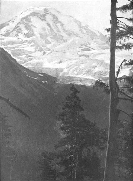
Taking heavy packs on our backs on the morning of July 21, we descended the steep broken surface of the most recent moraine bordering Carbon Glacier in its middle course, some idea of which is conveyed by Pl. LXXIV, and reached the solid blue ice below. Our course led us directly across the glacier, along the lower border of the rapidly melting covering of winter snow. The glacier is there about a mile across. Its central part is higher than its border, and for the most part the ice is concealed by dirt and stones. Just below the névé, however, we found a space about half a mile long in which melting had not led to the concentration of sufficient débris to make traveling difficult. Farther down the glacier, where surface melting was more advanced, the entire glacier, with the exception of a few lanes of clear ice between the ill-defined medial moraines, was completely concealed beneath a desolate sheet of angular stones. On reaching the east side of the glacier we were confronted with a wall of clay and stones, the inner slope of a moraine similar in all respects to the one we had descended to reach the west border of the glacier. A little search revealed a locality where a tongue of ice in a slight embayment projected some distance up the wall of morainal material, and a steep climb of 50 or 60 feet brought us to the summit. The glacier has recently shrunk—that is, its surface has been lowered from 80 to 100 feet by melting.
On the east side of the glacier we found several steep, sharp-crested ridges, clothed with forest trees, with narrow, grassy, and flower-strewn dells between, in which banks of snow still lingered. The ridges are composed of bowlders and angular stones of a great variety of sizes and shapes, and are plainly lateral moraines abandoned by the shrinking of the glacier. Choosing a way up one of the narrow lanes, bordered on each side by steep slopes densely covered with trees and shrubs, we found secure footing in the hard granular snow, and soon reached a more open, parklike area, covered with mossy bosses of turf; on which grew a great profusion of brilliant flowers. Before us rose the great cliffs which partially inclose the amphitheater in which Carbon Glacier has its source. These precipices, as already stated, have a height of about 4,000 feet, and are so steep that the snow does not cling to them, but descends in avalanches. Above the cliffs, where the inclination is less precipitous, the snow lies in thick layers, the edges of which are exposed in a vertical precipice rising above the avalanche swept rock-slope below. Far above, and always the central object in the wild scenery surrounding us, rose the brilliant white Liberty Cap, one of the pinnacles on the rim of the great summit crater. Our way then turned eastward, following the side of the mountain, and led us through a region just above the timber line, which commands far reaching views to the wild and rugged mountains to the northeast. This open tract, heading down to groves of spruce trees and diversified by charming lakelets, bears abundant evidence of having formerly been ice-covered, and is known its Moraine Park.
In order to retain our elevation we crossed diagonally the steep snow slopes in the upper portion of the Moraine Park. Midway over the snow we rested at a sharp crest of rock, and found that it is composed of light-colored granite. Later we found that much of the area between the Carbon and Winthrop glaciers is composed of this same kind of rock. Granite forms a portion of the border of the valley through which flow the glaciers just named, and furnished them with much granitic débris, which is carried away as moraines and later worked over into well-rounded bowlders by the streams flowing from the ice. The presence of granite pebbles in the courses of Carbon and White rivers far below the glaciers, is thus accounted for.
A weary tramp of about 4 miles from the camp we had left brought us to the border of Winthrop Glacier. In the highest grove of trees, which are bent down and frequently lie prone on the ground, although still hiving, we selected a well-sheltered camping place. Balsam boughs furnished luxuriant beds, and the trees killed by winter storms enabled us to have a roaming camp fire. Fresh trail of mountain goats and their but recently abandoned bed showed that this is a favorite resort for those hardy animals. Marmots were also abundant, and frequently awakened the echoes with their shrill, whistling cries. The elevation of our camp was about 8,000 feet.
From our camp on the cliffs above the west border of Winthrop Glacier we made excursions across that glacier and to its heavily moraine-covered extremity. The snow mantle that is spread over the region about Mount Rainier each winter melts first on the rugged plateau surrounding the base of the mountain, and, as the summer's heat increases, gradually withdraws up the mountain sides, but never so as to uncover the more elevated region. The snow line—that is, the position to which the lower border of the mantle of perennial snow withdraws late in summer—has an elevation of about 9,000 feet. The lower margin of the wintry covering is always irregular, however, extending farthest down on the glaciers and retreating highest on the rocks. At the time of our visit the snow had melted off of nearly all the region below our camp, leaving only dirt-stained snow banks in the more completely sheltered recesses and in deeply shaded dells in the adjacent forests. On the glaciers all the region at a greater elevation than our camp was white and free from dirt and stones, while the hard glacial ice was abundantly exposed at lower altitudes and ended in a completely moraine-covered terminus. Above us all was barren, white, and wintry; below lay the flowery vales and grass parks, warm and inviting, leading to the welcome shade of noble forests. Our course led upward into the frozen region.
TO THE WEDGE.
On leaving the camp on the border of Winthrop Glacier we began our alpine work. There were five in the party selected for the difficult task of scaling Mount Rainier, namely: Willis, Smith, Ainsworth, Williams, and myself. Taking our blankets, a small supply of rations, an alcohol lamp, alpenstocks, a rope 100 feet long to serve as a life line, and a few other articles necessary for traveling above timber line, we began the ascent of Winthrop Glacier early on the morning of July 23. Our route was comparatively easy at the start, but became steeper and steeper as we advanced. The snow was firm and, except for the numerous crevasses, presented no great difficulties to be overcome. In several places the névé rises in domes as if forced up from beneath, but caused in reality by bosses of rock over which the glacier flows. These domes are broken by radiating crevasses which intersect in their central portions, leaving pillars and castle-like masses of snow with vertical sides. At one locality, in attempting to pass between two of these shattered domes, we found our way blocked by an impassable crevasse. Considerable time was lost in searching for a practicable upward route, but at length, by making a detour to the right, we found a way which, although steep, allowed us to pass the much crevassed area and gain the sharp ridge of rock which divides the névé snow flowing from the central dome of the mountain, and marks the separation between Winthrop and Emmons glaciers. This prow-like promontory, rising some 500 feet above the glaciers on either hand, we named The Wedge. This is the upward pointing, acute angle of a great V-shaped portion of the lower slope of the mountain, left in bold relief by the erosion of the valleys on either side. As will be described later, there are several of these remnants about the sides of the mountain at the same general horizon, which record a somewhat definite stage in the destruction of the mountain by ice erosion.
On reaching The Wedge we found it an utterly desolate rocky cape in a sea of snow. We were at an altitude of about 10,000 feet, and far above timber. Water was obtained by spreading snow on smooth rocks or on rubber sheets, and allowing it to melt by the heat of the afternoon sun. Coffee was prepared over the alcohol lamp, sheltered from the wind by a bed sheet supported by alpenstocks. After a frugal lunch, we made shelf like ledges in a steep slope of earth and stones and laid down our blankets for the night. From sheltered nooks amid the rocks, exposed to the full warmth of the declining sun, we had the icy slopes of the main central dome of the mountain in full view and chose what seemed the most favorable route for the morrow's climb.
Surrounded as we were by the desolation and solitude of barren rocks, on which not even a lichen had taken root, and pure white snow fields, we were much surprised to receive passing visits from several humming birds, which shot past us like winged jewels. They came up the valley occupied by the Emmons Glacier, turned sharply at The Wedge, and went down the way of the Winthrop Glacier. What tempts these children of the sunlight and the flowers into the frozen regions seems a mystery. That the humming birds are bold explorers was not new to me, for the reason that on several occasions in previous years, while on the snow-covered slopes of Mount St. Elias, far above all vestiges of vegetation, my heart had been gladdened by glimpses of their brilliant plumage.
When the sun declined beyond the great snow-covered dome that towered above us, and the blue shadows crept down the previously dazzling cliffs, the air became cold and a strong wind made our perch on the rocks uncomfortable. Wrapping ourselves in our blankets we slept until the eastern sky began to glow with sunrise tints.
TO THE SUMMIT.
Early on the morning of July 24 we began the climb of the steep snow slopes leading to the summit of the mountain. Roped together as we had been on the previous day, we slowly worked our way upward, in a tortuous course, in order to avoid the many yawning crevasses. The way was steep and difficult. Some members of the party felt the effects of the rarefied air, and as we lacked experience in true alpine work our progress was slow and laborious. Many of the crevasses that our course crossed were of the nature of faults. Their upper rims stood several feet above their lower margins, and thus added to the difficulty of passing them. Our aim at first was to traverse the névé of Emmons Glacier and gain the less rugged slope bordering it on the south, but the intervening region was greatly broken and, as we found after several approaches to it, utterly impassable. The climb presented no special difficulties other than the extreme fatigue incident to climbing steep snow slopes, especially while attached to a life line and the delays necessitated by frequently turning and retracing our steps in order to get around wide crevasses.
|
| Pl. LXVIII. MOUNT RAINIER, THE LIBERTY CAP AND WILLIS GLACIER, FROM THE TRAIL NEAR EAGLE CLIFF; LOOKING SOUTHEAST. |
Once while crossing a steep snow slope diagonally, and having a wide crevasse below us, Ainsworth, who was next to the rear of the line, lost his footing and slid down the slope on his back. Unfortunately, at that instant, Williams, who was at the rear of the line, removed his alpenstock from the snow, was overturned by the pull on the line, and shot head first down the slope and disappeared over the brink of the crevasse. A strong pull came on the members of the party who were in advance, but our alpenstocks held fast, and before assistance could be extended to the man dangling in midair, he climbed the taut rope and stood unhurt among us once more. The only serious result of the accident was the loss of an alpenstock.
Pressing on toward the dark rim of rock that we could now and then catch glimpses of at the head of the snow slopes and which we knew to be the outer portion of the summit crater, we crossed many frail snow bridges and climbed precipitous slopes, in some of which steps had to be cut. As we neared the summit we met a strong westerly gale that chilled us and benumbed our fingers. At length, weary and faint on account of the rarity of the air, we gained the lower portion of the rim of stones marking the position of the crater. While my companions rested for a few moments in the shelter of the rocks, I pressed on up the rugged slope and gained the top of the rim.
The stones exposed at the summit are bare of snow, possibly on account of the heat from below, and are rounded and their exposed surfaces polished. The smooth, black bowlders shine in the sunlight much the same as the sand-burnished stones in desert regions. Here on the mountain's brow, exposed to an almost continuous gale, the rocks have been polished by drifting snow crystals. The prevailing rounded form that the stones present may be the result of weathering, or possibly is due to the manner in which the fragments were ejected from the volcano. My hasty examinations suggested the former explanation.
Descending into the crater, I discovered crevices from which steam was escaping, and on placing my hands on the rocks was rejoiced to find them hot. My companions soon joined me, and we began the exploration of the crater, our aim being to find the least uncomfortable place in which to take refuge from the freezing blast rather than to make scientific discoveries.
The crater that we had entered is one of the smaller and more recent ones in the truncated summit of the peak, and is deeply filled with snow, but the rim is bare and well defined. The steam and heat from the rocks have melted out many caverns beneath the snow. In one of these we found shelter.
A NIGHT IN THE CRATER.
The cavern we chose in which to pass the night, although irregular, was about 60 feet long by 40 wide, and had an arched ceiling some 20 feet high. The snow had been melted out from beneath, leaving a roof so thin that a diffused blue light penetrated the chamber. The floor sloped steeply, and on the side toward the center of the crater there was a narrow space between the rocks and the descending roof which led to unexplored depths. As a slide into this forbidding gulf would have been exceedingly uncomfortable, if not serious, our life line was stretched from crag to crag so as to furnish a support and allow us to walk back and forth during the night without danger of slipping. Three arched openings or doorways communicated with other chambers, and through these drafts of cold air were continually blowing. The icy air chilled the vapor rising from the warm rocks and filled the chamber with steam which took on grotesque forms in the uncertain, fading light. In the central part of the icy chamber was a pinnacle of rock, from the crevices of which steam was issuing with a low hissing sound. Some of the steam jets were too hot to be comfortable to the ungloved hand. In this uninviting chamber we passed the night. The muffled roar of the gale as it swept over the mountain could be heard in our retreat and made us thankful for the shelter the cavern afforded.
The floor of our cell was too uneven and too steeply inclined to admit of lying down. Throughout the night we leaned against the hot rocks or tramped wearily up and down holding the life line. Cold blasts from the branching ice chambers swept over us. Our clothes were saturated with condensed steam. While one side of the body resting against the rocks would be hot, the strong drafts of air with a freezing temperature chilled the other side. After long hours of intense darkness the dome of snow above us became faintly illuminated, telling that the sun was again shining. After a light breakfast and a cup of tea, prepared over our alcohol lamp, we resumed our exploration, none the worse for the exposures of the night.
ON CRATER PEAK.
Following the inner rim of the crater so as to be sheltered from the gale still blowing steadily from the west, we gained its northern border and climbed to the topmost pinnacle, known as Columbia's Crest. This pinnacle rises about 50 feet above the general level of the irregular rim of the crater, and is the highest point on the mountain. Its elevation, as previously stated, is 14,526 feet.
The magnificent view described by former visitors to this commanding station, which we had hoped would reward our efforts, was concealed beneath a canopy of smoke that covered all of the region about the mountain to a depth of about 10,000 feet. The surface of the layer of smoke was sharply defined, and appeared like an undulating sea surrounding the island on which we stood. Far to the northward rose the regular conical summit of Mount Baker, like an isolated seagirt island. A few of the rugged and more elevated summits, marking the course of the Cascade Mountains, could be discerned to the eastward. The summits of Mount Adams and Mount St. Helens were in plain view and seemingly near at hand. All of the forest-covered region between these elevated summits was blotted out by the dense, heavy layer of smoke, which rose until it met the westerly gale of the upper regions.
During the ascent of Mount Rainier by Emmons and Wilson, previously referred to, more favorable atmospheric conditions prevailed than at the time of my visit, and the region about the base of the mountain was clearly revealed. In describing the view from the summit Emmons says:
From the northeastern rim of the crater we could look down an unbrokensSlope of nearly 10,000 feet to the head of the White River, the upper half or two-thirds of which was so steep that one had the feeling of looking over a perpendicular wall. [It was up this slope that the climb briefly described above was made.] The systems of glaciers and the streams which flowed from them lay spread out as on a map at our feet; radiating out in every direction from the central mass, they all with one accord curve to the westward to send their waters down toward Puget Sound or the Lower Columbia. [Attention has already been directed to the westward curvature of the streams from Mount Rainier on reaching the tilted peneplain on which the mountain stands, and the explanation has been suggested that they are consequent streams the direction of which was determined by the original slope of the now deeply dissected plateau.]
Looking to the more distant country, the whole stretch of Puget Sound, seeming like a pretty little lake embowered in green, could be seen in the northwest, beyond which the Olympic Mountains extend out into the Pacific Ocean. The Cascade Mountains, lying dwarfed at our feet, could be traced northward into British Columbia, and southward into Oregon, while above them, at comparatively regular intervals, rose the ghost-like forms of our companion volcanoes. To the eastward the eye ranged for hundreds of miles over chain on chain of mountain ridges, which gradually disappeared in the dim, blue distance.
| <<< Previous | <<< Contents >>> | Next >>> |
rpt/18-2/sec1-5a.htm
Last Updated: 28-Mar-2006