
|
University of Washington Publications in Geology
The Geomorphology and Volcanic Sequence of Steens Mountain in Southeastern Oregon |
THE VOLCANIC SEQUENCE
(continued)
STEENS MOUNTAIN BASALT
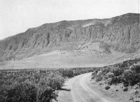
The Upper Andesite is capped by an extensive series of thin basaltic flows (figs. 6 and 60) that extend to the summit of the mountain, about 3000 feet above. This great thickness, however, is far from a maximum figure inasmuch as the near-vent phases of the earlier volcanic rocks, on which the basalt rests, probably formed a marked topographic feature at the time of this later extrusion.
|
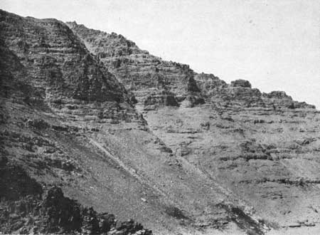
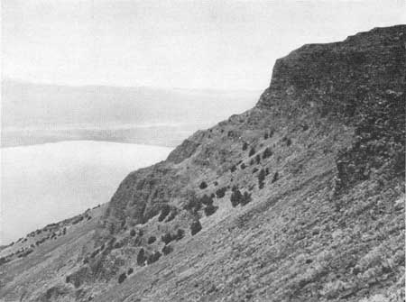
| Fig. 60. View of the basaltic flows exposed above the cirque of the south fork of Alvord Creek. On the left the cliff rises nearly 1000 feet. |
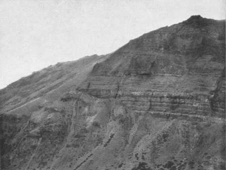
Although the uppermost surface of the underlying andesite fluctuates as it is traced from divide to divide, it retains in general a relatively uniform height. To the south, the top of the Pike Creek volcanic series is almost at the same level. Traced westward into the glacial cirques, the elevation of the upper surface of the andesite decreases gradually with an inclination, which is locally over 15° (fig. 61). The thin basaltic flows lap against this inclined surface.
|
| Fig. 61. The basaltic flows abutting against the surface of the andesite on the southern side of the south fork of Willow Creek. |
Only to the south of Alvord Creek was the actual basal contact of the basalt observed. There, the surface of the andesite, sloping westward, is capped by a slight thickness of poorly stratified andesitic tuffs, which show no marked indication of erosion. Elsewhere, distant views of the gently undulating contact, do marking the base of the basalt as it abuts against the andesite, suggest that the domed structure, formed by the accumulation of viscous lava, had been relatively unmodified at the time of the basaltic extrusion.
GENERAL DESCRIPTION
This series consists chiefly of thin flows of coarsely holocrystalline olivine basalt of a rather light gray color. The rock is distinctive in the field both from a peculiar porous texture, which is quite characteristic, and from its local content both of labradorite phenocrysts ranging from 1 to 4 cm. in length, and of olivine grains, which are predominantly under 2 mm. in diameter. These flows have been found to vary in thickness from less than one foot to over 70, but they average approximately 10 feet. Although most of them retain their thickness, at least locally, without any marked variations, some of the thinner ones end in contortions.
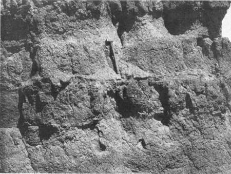
The vesicular upper surface of each sheet is usually remarkably level, while the base as a rule is defined by the development of pipelike vesicles, which are presumably caused by the rising of air imprisoned beneath an advancing flow. At a number of localities well-defined contacts have been found to disappear on being traced laterally, although the physical characteristics such as vesicles, phenocrysts or jointing may still render the two sheets apparent (fig. 62). This merging of successive sheets is attributed to the advance of very fluid lava prior to the complete solidification of the surface of a lower flow, which had become approximately stationary.
|
| Fig. 62. Near the base of the scarp of Northern Steens about a mile to the south of the main fault spur. Thin flows of basalt may be seen partially merging. |
In the valleys of both Little Alvord and Pike Creeks, the contacts of many of the lower flows of the series are irregular and indistinct. As a rule they are defined by a fairly well consolidated zone of finely brecciated scoria, which more rarely exhibits large tilted blocks of thin scoraceous layers. Into this roughly horizontal zone, the base of the overlying flow forms irregular embayments. Presumably the weight of the advancing sheet brecciated the superficially solidified surface of the underlying lava. Beneath this breccia, the basalt has locally developed a peculiar vertical spinous jointing, which the writer attributes to this minor deformation during the process of solidification.
In the lower cirque of Mosquito Creek, at the base of the series, there is a bed of well-stratified grey tuffs about 10 feet in thickness. Higher in the section there are at least two still smaller beds of buff colored tuffs that are very local in their distribution. In the valley of Alvord Creek almost in the center of the basaltic series, there is interbedded a thin mass formed of a black rather vitreous rock which contains thick laths of andesine about 2 mm. in length. Chemical analysis proves this rock to be an andesite of intermediate composition (table IX). Owing both to poor and to inaccessible exposures it has not yet been determined if this mass is a flow or a concordant intrusive. Aside from these small units, which probably comprise no more than 30 feet of an entire section, the consecutive flows on High Steens appear to be in perfect continuity, for flow breccias and basaltic ejectamenta are practically negligible.
Local variations, however, may be found in the series. To the north, vesicular flow breccias are more prevalent. Southwest of Andrews on the broad shoulder at the base of the scarp, there are exposures of extensive palagonic tuffs containing an irregular distribution of chilled masses of typical porphyritic basalt. The evidence obtained did not permit an interpretation of the origin of this facies, although the chilling suggests aqueous agencies. In adjacent regions, other variations are due to the fact that the more acidic lavas of various types are interbedded in the series.
Unlike the Columbia River Basalt, these flows do not show columnar structure, although they are cut by roughly vertical joints, which form broad, gently curving surfaces. These intersect irregularly and bound blocks, which, even in thin flows, are frequently found to be four or five feet in diameter. In general, in spite of the thinness of the flows, the jointing from its coarseness superficially resembles that of a plutonic rock more than that of a lava. Some of the major joints have also smaller systems normal to their surface.
On steep cliffs and pinnacles, the jointing causes each flow to stand out distinctly, but on the slopes where the rock has been subjected to the abrasion of sliding talus, the flows are bevelled to a fairly smooth surface and usually show no topographic expression although continuously exposed (fig. 74). This uniform bevelling is due to the relative softness of the rock. The variations in erosion may thus cause the character of an exposure to change so sharply as to suggest erroneously the presence of a fault.
DISTRIBUTION
Owing to their exceptional fluidity, these basaltic flows have developed very distinctive textural peculiarities, although both their mineralogical and chemical composition is for the most part normal. These characteristics, which will be described later, distinguish the rock easily from flows of the Columbia River Basalt. Unfortunately some of the textural peculiarities appear to have persisted in the region over a considerable span of time, for similar flows in a number of instances are widely separated stratigraphically. As a whole, however, the occurrence of a rather thick series, showing the more distinctive characteristics, permits a fairly definite correlation, which is especially justified since a wide distribution may be expected from the fluidity of the lava.
On the eastern scarp of Steens and Pueblo Mountains, these flows are exposed almost continuously for a distance of about a hundred miles. Only on High Steens is the base of the series well defined, although on Pueblo Mountain its position is strongly suggested. At the southern end of this persistent scarp the flows dip to the south beneath the alluvium of the Thousand Creek valley. Farther to the south, the fault block mountains expose the older crystalline rocks with apparently the total absence of the series. The possible relationship of these flows to the Mesa Basalt of this region will be discussed later.
Northward a large section of the series is exposed continuously on the eastern scarp of Northern Steens for a distance of about 30 miles. In this region many of the flows are somewhat more aphanitic and more acidic than usual. Vesicular flow breccias are more commonly encountered. Northwest of Alberson, in the lower portion of the scarp, there is interbedded with the basalt a 300 foot flow of dark aphanitic rock which closely resembles the glassy facies of the Upper Andesite. In thin section, sodic andesine may be observed in unzoned phenocrysts which range up to 3 mm. in length. The glassy ground as a rule is clouded with indeterminable microlites, but some specimens show numerous clean-cut feldspathic laths in a pale brownish glass. A chemical analysis of the fresh rock showed the composition to be that of a fairly acidic latite (table X). Near the base of the scarp the discordant relation of the latite and its breccias indicate that this lava was derived from local sources during the outpouring of the basaltic floods.
To the north, in Harney Basin, the fault scarps decrease in height so that only the members capping the basalt are usually exposed. In a general reconnaissance of the region farther to the north, the writer has failed to observe any similar basalt. The series do not resemble any member of the extensive section now being studied by Ralph L. Lupher13 in the Ochoco Mountains to the north of Burns between Canyon City and Crow Flat. In this vicinity, the southern slope of the structure indicates that the uppermost members of the volcanic series underwent minor deformation during at least the most recent uplift of this part of the range, but the Steens Mountain Basalt and the lower members are considered by the writer to have been confined to a broad basin that lay to the south.
13This statement is based on a personal examination of Dr. Lupher's specimens.
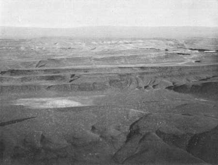
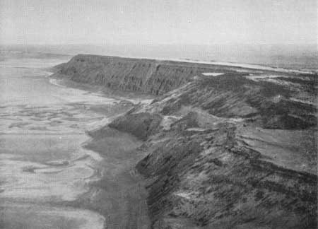
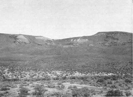
To the east of Alvord Desert the elevation of the fault blocks gradually decreases and at the same time the mantling sequence of tuffs and lavas increases (fig. 63), because of the less rigorous erosion at a lower elevation. The series has no analogy to the basaltic flows exposed in the Owyhee Gorge about 70 miles to the northeast. To the southeast of Steens Mountain, the western scarp of the McDermitt Valley depression rises close to 1500 feet in height. A few basaltic flows resembling the Steens Mountain type occur both at the base and near the top of the series. Acidic lavas about 1000 feet in thickness lie in the intervening space. The upper basalt beneath a thin cap of glassy acidic lava consists of three flows varying in thickness from 5 to 10 feet. These flows, which are rich in phenocrysts of labradorite, are identical to characteristic types of the Steens Mountain series. This relationship suggests that the extrusion of the acidic lavas was contemporaneous with the outpouring of the great basaltic floods.
|
| Fig. 63. Aeroplane view to the east from north of Upper Alvord basin. The light colored exposures in the middle distance are formed by the tuffaceous deposits overlying the basaltic series. In the foreground the step faults are remarkably well defined. |
In Southern Steens, the uppermost flows on the eastern scarp can be traced across the slightly dissected horst, known as Smith Flat, to the western scarp where again the series shows a depth of over 1000 feet. Southward this curving scarp exposes the basaltic flows continuously until it ends abruptly in a transverse fault. South of this point both the geology and the topography are complicated by irregular minor faults and by the occurrence of a large homogeneous mass of dense altered porphyry forming Lone Mountain. This rock, which contains small feldspathic phenocrysts, is somewhat similar to the upper biotite dacite of the Pike Creek Volcanic Series, and likewise erodes locally into pinnacles that suggest vertical flowage and therefore the position of a vent. The relationship of the porphyry to the southern continuation of the Steens Mountain Basalt was not determined. Southeast of Lone Mountain the exposures consist of stratified tuffs overlain by a thin layer of basalt, which presumably is a continuation of the Mesa Basalt described by Merriam.14 No conclusive evidence on the relationship of this basalt to the northern series was here obtained. The possibility of correlation will be considered later.
14J. C. Merriam, "Tertiary Mammal Beds of Virgin Valley and Thousand Creek in Northwestern Nevada," Univ. Calif. Publ., Bull. Dept. Geol. Sci., vol. VI, pp. 36-38. 1910.
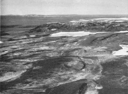
To the west near the Nevada border the surface rock is formed largely of basalt, but the exposures are not of sufficient magnitude to permit its correlation with that of Steens Mountain. Even in Guano Valley the scarps are low and the exposures unsatisfactory (fig. 64). Slightly to the north, however, in Warner Valley and still farther to the west at Abert Rim, there is exposed a series of thin basaltic flows, which show a total thickness of about 1500 feet. Although differing in detail, the series at these localities is similar to that of Steens Mountain in its general petrological characteristics as well as in its structural relationship. It may, therefore, be correlated with practical certainty. Similar flows, although not the most characteristic types, also form the small scarps bounding Pauline Marsh, but the vicinity was not studied in sufficient detail to permit a definite correlation. Farther to the west the exposure of older rocks appears to mark the margin of the volcanic basin. More flows of olivine basalt, however, are exposed in the scarp east of Klamath Lake. Although these are also somewhat similar, they show predominantly a glomeroporphyritic texture that is quite distinctive. They may therefore be part of a separate series.

|
| Fig. 64. Aeroplane view of the eastern scarp of Guano Valley from the north. The volcanic cone of Beatty's Butte is in the foreground. |
The distribution of the sequence exposed in Warner Valley demands more detailed consideration in view of the previous correlation of this great series with the Warner Basalt when the latter was described by R. J. Russell in his paper on the Warner Range of California.15 This range forms the eastern wall of Surprise Valley, which is a southern continuation of Warner Valley. In this region Russell found a varied sequence of andesitic flows and tuffs to be locally capped by a series of basaltic flows which show a maximum thickness of 600 feet. This basalt is in part overlain by rhyolite.
15R. J. Russell, "Basin Range Structure and Stratigraphy of the Warner Range, Northeastern California," Univ. Calif. Publ., Bull. Dept. Geol. Sci., vol. XVII, pp. 416-425, 1928.
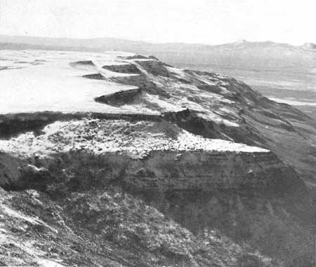
About 40 miles north of the Nevada border, an elevated portion of the eastern scarp of Warner Valley is known as Bluejoint Rim. Here, about 1500 feet of basalt is exposed above the talus (fig. 65). These flows exhibit almost all of the peculiarities that characterize the Steens Mountain series. To the south, this eastern block diminishes gradually in elevation until at a transverse fault it is sharply uplifted to form the relatively narrow horst known as Hart Mountain (fig. 66), which is bounded by a fairly low scarp on the east, and, on the west, by one that rises over 3000 feet as the eastern boundary of Warner Valley.
|
| Fig. 65. Aeroplane view of Bluejoint Rim, which rises about 1800 feet as the eastern scarp of Warner Valley. R. E. Fuller and A. C. Waters, op. cit., fig. 2, p. 212. Subsequently reproduced in the third edition of L. V. Pirrson's and Charles Schuchert's Text-Book of Geology, part I, fig. 269, p. 386. |
|
| Fig. 66. Aeroplane view of the southern end of the eastern scarp of Hart Mountain. The flat top of the narrow horst is visible on the right. In the middle distance, directly to the left, the western scarp of Warner Valley may be seen. |
Hart Mountain is composed of a complex series of lavas and volcanic intrusions. The lowest exposed member of the local stratigraphic sequence consists of a few badly decomposed basaltic flows of a phenocrystic lava that is also strongly suggestive of a Steens mountain type. This lava is overlain by rather viscous flows of acidic basalt extruded from local vents. Above this there is a varied sequence of tuffs and andesitic flows. This series is cut by a number of andesitic sheets that dip at low angles towards the center of the mountain. These intrusions, which resemble petrographically the uppermost flows, vary in thickness from a few feet to about 200. The summit of the andesite rises a few hundred feet above the subsequent basaltic flows that abut against it.
Gradually increasing in depth towards the north these flows show a thickness of at least 700 feet at the northern end of the western scarp of Hart Mountain. Here the base is not well defined, but the lower exposures indicate that the series overlies some rather acidic basaltic flows, which are accompanied by much scoraceous lava. Judging from the evidence of viscosity, this lower basalt is of local distribution, but the overlying series from its physical characteristics appears to be the direct continuation of that which is exposed at Bluejoint Rim. At the northern end of Hart Mountain (fig. 67), these flows are locally overlain by a thickness of approximately 125 feet of stratified, light colored tuffs that are capped by a basaltic flow about 20 feet in thickness. This flow, which survives in a local butte, is also similar to a less distinctive Steens Mountain type.
|
| Fig. 67. Aeroplane view of the western scarp of Hart Mountain at the northern end of the horst. At the top, the butte is capped by basaltic flows considered to be the northern continuation of the Warner Basalt. The slope beneath it marks the position of the tuffaceous sediments. The precipitous exposures below the shoulder are formed by the basaltic flows of the Steens Mountain series. On the right these flows show a maximum thickness of about 700 feet. |
To the south, the andesite forming the central portion of Hart Mountain is also overlain by basaltic flows that in the southern portion of the mountain are about 1300 feet in thickness (fig. 68). These flows appear identical to the Bluejoint series except for the fact that phenocrysts of labradorite are less common. This lava is locally overlain by a flow of andesite filled with inclusions that appear to have a cognate origin. Lower on the scarp, exposures of this same andesite suggest a crosscutting relationship.
|
| Fig. 68. Basaltic flows about 1300 feet in thickness capping the southern end of Hart Mountain. These flows are considered to correlate with the Steens Mountain series. Warner Lake is visible at the base of the scarp, which here is over 3000 feet in height. |
The horst forming Hart Mountain is bounded on the south by a fault. Farther to the south, the scarp defining the eastern wall of Warner Valley continues with a height of about 1200 feet. This lower scarp is capped by two thin basaltic flows. Their base is hidden by coarse talus that continues downward for about 200 feet. Below this, there is exposed a dense dark grey rock filled with inclusions. This rock appears identical to that capping the southern end of Hart Mountain. Here however, its jointing suggests that it may be an intrusive phase. Beneath this exposure, there outcrops a single thin basaltic flow that rests slightly disconformably on stratified tuffs about 400 feet in thickness. Below these beds, thin basaltic flows, extending to the talus, show a total thickness of over 200 feet. This lava is very similar to that which is exposed in the section at the southern end of Hart Mountain. Although the two localities are only about a mile apart, the lack of exposures renders it impossible to explain the absence of the tuffs beneath the andesite capping the series to the north.
On the western side of Warner Valley the relationship is simpler. In a central portion of the valley, the western scarp is lacking, although basaltic flows are exposed at the Coyote Hills, where they have been uparched by the intrusion of acidic lava.16 To the south of Plush the scarp reappears above the alluvium, and exposes a thickness of over 200 feet of basalt disconformably overlying stratified tuffs that locally show a thickness of about 100 feet. These beds appear similar to those both at the north of Hart Mountain and in the scarp to the south of the mountain.
16R. J. Russell, op. cit., p. 427.
Traced southward, the western scarp gradually increases in elevation. West of the northern end of Warner Lake it reaches a maximum of about 2300 feet (fig. 69). The block, here, is capped by about 400 feet of basalt, which is the stratigraphic continuation of the exposures to the north. The base of this uppermost basalt is covered by soil and talus which continues downward for about 300 feet. This slope ends in a persistent shoulder formed by the surface of an underlying series of basaltic flows. In this soil-clad zone, which can be traced for the length of the scarp, were found fragments of consolidated light colored tuffs. To the north in two localities tuffs outcrop at this same horizon. In consequence, this shoulder is considered to be formed by the continuation of the tuffaceous beds occurring to the north beneath the basaltic cap.
|
| Fig. 69. The 2300 foot scarp west of Warner Lake. About 300 feet of basalt, which presumably represents the Warner Basalt, overlies tuffaceous sediments. These beds, which are thought to be part of the Upper Cedarville, form a persistent tree-clad horizon of about equal magnitude. The prominent exposures at the base are formed by a series of basaltic flows about 1300 feet in thickness. These flows are correlated with those of Steens Mountain. |
Below these tuffs, however, are precipitous exposures of thin basaltic flows that appear to be identical to those forming the great cap at the southern end of Hart Mountain on the opposite side of the graben. These flows form a continuous outcrop over 1000 feet in height. Although they also are not so porphyritic, they presumably form the southern continuation of those of Bluejoint and Abert Rims, and are, therefore, thought to he part of the Steens Mountain series.
The overlying tuffs both from their lithologic similarity and from their uniform stratigraphic relationship are considered to correlate with those to the south of Hart Mountain as well as with those in the butte at the north end of the mountain, while the basaltic flows capping these beds are thought in each of these localities to belong to the same later series. This interpretation indicates that both the upper tuffs and the basalt, which caps them, decrease in thickness to the north.
Russell considered the capping basalt on the western side of Warner Valley to be the direct continuation of the Warner Basalt, but he did not realize the presence of the underlying series. In fact, referring to this scarp, Russell states17 "While the capping of Warner Basalt is relatively thin in that area, its debris so thoroughly covers the Upper Cedarville beds that only careful search will reveal their presence. It is likely that this condition caused Waring to indicate a great thickness of basalt in the cliff west of Warner Lake while in actuality the flow is relatively thin."
17Op. cit., pp. 439-440.
From this interpretation the capping tuffs are considered to be part of the Upper Cedarville, while the overlying flows are correlated with the Warner Basalt. The underlying series in consequence must be earlier than the Upper Cedarville, although the intervening time probably is insignificant. Southward the capping basalt appears to merge into the exposures in the Warner Range, but the relationship of the lower series to that of the Warner Range was not determined.
The difficulty in correlating isolated horizons of basalt is well shown on the eastern scarp of Surprise Valley about 15 miles to the east of Cedarville (fig. 70). Here basaltic flows about 60 feet in thickness overlie light colored tuffs which are more than twice as thick. These in turn rest conformably on thin basaltic flows about 125 feet in thickness. Beneath these is another bed of acidic tuffs forming an horizon of about the same depth. These lower tuffs rest on more basaltic flows whose base is not exposed. The uppermost basalt has no analogy to the northern lavas and is presumably later. The other two horizons, from their physical characteristics, might be correlated with the Warner Basalt and the northern series respectively, but the evidence is not conclusive. The exposure, however, at least shows the futility of classing all the basalt in the region as a single stratigraphic unit.
|
| Fig. 70. The eastern scarp of Surprise Valley to the east of Cedarville. On the left the butte at the top is formed by about 150 feet of tuffaceous sediments, which are capped by a few thin basaltic flows. Beneath these beds in the center of the picture about 125 feet of basalt overlies a slightly greater thickness of stratified tuffs, which rest on still lower basaltic flows of unknown thickness. |
| <<< Previous | <<< Contents >>> | Next >>> |
state/wa/uw-1931-3-1/sec4i.htm
Last Updated: 28-Mar-2006