
|
University of Washington Publications in Geology
The Geomorphology and Volcanic Sequence of Steens Mountain in Southeastern Oregon |
THE VOLCANIC SEQUENCE
(continued)
THE LATER SERIES
On top of Northern Steens some fragments of acidic lava suggest that a capping flow of that type may have been removed by erosion. On High Steens the basaltic flows form the surface of the block. South of Smith Flat, however, the rugged crest of Southern Steens is capped by reddish brown lava which is disconformable to the basaltic series. This flow, which is at least 150 feet in thickness, appears to be a typical trachyte. In thin section small phenocrysts of orthoclase are found in a ground formed of indistinct roughly aligned feldspathic microlites, which were not determinable.
In the southern part of Pueblo Mountain a flow of grey rhyolite caps the basaltic series. This flow, which is about 300 feet in thickness, shows partially resorbed phenocrysts of quartz about 2 mm. in diameter in a cryptocrystalline groundmass. It was once suggested by Merriam25 that this flow might correlate with the Canyon Rhyolite to the south. Aside from the increased discrepancy between the ages of their overlying sediments, which has already been discussed, chemical analyses of the two lavas suggest a distinctive origin (table IX).
25J. C. Merriam, "Tertiary Mammal Beds of Virgin Valley and Thousand Creek in Northwestern Nevada," Univ. Calif. Publ., Bull. Dept. Geol. Sci., vol. VI, p. 32, 1910.
TABLE IX
|
Part 1 | |||
| Silica | 58.45 | 73.80 | 78.60 |
| Alumina | 18.25 | 12.45 | 9.94 |
| Ferrous Oxide | 4.55 | .93 | .85 |
| Ferric Oxide | 1.80 | 1.53 | .74 |
| Magnesia | 2.38 | .28 | .11 |
| Lime | 6.32 | .96 | .70 |
| Soda | 3.56 | 3.72 | 3.30 |
| Potash | 2.83 | 5.35 | 4.33 |
| Water above 105° C | .90 | .40 | .40 |
| Water at 105° C | .40 | .30 | .70 |
| Titanium Dioxide | .40 | .12 | .24 |
| Carbon Dioxide | none | none | none |
| Phosphorus Pentoxide | trace | trace | trace |
| Sulphur | .07 | trace | trace |
| Manganese Dioxide | trace | trace | none |
99.91 | 99.84 | 99.91 | |
|
I. Andesitic sheet of undetermined relationship interbedded with the Steens Mountain Basalt about 1,500 feet below the summit. Analyst W. H. Herdsman. II. Rhyolite flow capping the series at the southern end of Pueblo Mountain. Analysts W. H. and F. Herdsman. III. The Canyon Rhyolite in Virgin Valley underlying the Virgin Valley Beds. Analysts W. H. and F. Herdsman.
| |||
| Quartz | 8.52 | 30.06 | 41.76 |
| Orthoclase | 16.68 | 31.14 | 25.58 |
| Albite | 29.87 | 31.44 | 26.72 |
| Anorthite | 25.30 | 1.67 | -- |
| Acmite | -- | -- | .92 |
| Diopside | 5.07 | 2.26 | 2.13 |
| Wollastonite | -- | .12 | .46 |
| Hypersthene | 9.58 | -- | -- |
| Magnetite | 2.55 | 2.09 | .46 |
| Ilmenite | .76 | .15 | .61 |
| Sulphur | .07 | -- | -- |
| Water | 1.30 | .70 | 1.10 |
99.70 | 99.63 | 99.74 | |
|
Norms calculated from the analyses in Part 1: | |||
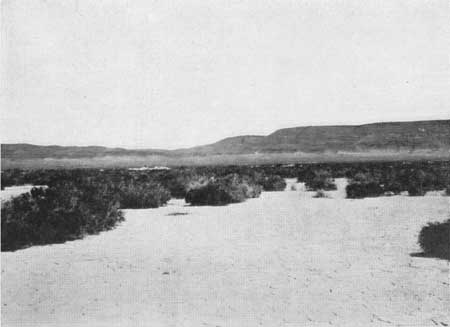
East of Alvord Desert the basaltic series exposed in Upper Alvord Basin gradually decreases in elevation with a gentle dip to the south. Before the uppermost flows of this Steens Mountain Basalt disappear beneath the alluvium, an overlying series of tuffs and lavas are exposed above them. This series, which shows a thickness of almost 600 feet, forms a butte about four miles in length (fig. 77). On the north it is completely truncated by an erosional escarpment. At the southern end of the butte, a far lower escarpment marks the removal of the upper half of the series. Farther to the south the lower members continue to form the fault scarp for several miles, until they end abruptly where the underlying basalt is again exposed by a transverse fault.
|
| Fig. 77. The scarp east of Alvord Desert, showing in the center the northern end of the butte in which the later members of the series survive. To the left the structure may be seen to be gently dipping southward. The basaltic flows capping the butte are slightly non-conformable. |
The lowermost exposures above the basalt are formed of a black, rather vitreous lava, which was proved by the chemical analysis to be a latite, very similar to that interbedded with the basalt on Northern Steens (table X). In thin section it shows roughly aligned feldspathic microlites in a glassy ground. This latite forms an exposure of about 200 feet in thickness and can be traced southward at least five miles. From its persistence it appears to form a stratigraphic unit, but its characteristics, wherever observed, suggest that it directly overlies a fissure-like vent which was later paralleled by a very straight north-south fault.
TABLE X
|
Part 1 | |||
| Silica | 65.20 | 62.30 | 78.55 |
| Alumina | 15.80 | 15.22 | 9.82 |
| Ferrous Oxide | 4.35 | 2.73 | .92 |
| Ferric Oxide | .89 | 3.56 | 1.11 |
| Magnesia | .13 | .82 | .14 |
| Lime | 3.40 | 3.32 | .68 |
| Soda | 4.13 | 4.00 | 3.57 |
| Potash | 3.90 | 3.49 | 4.34 |
| Water above 105° C | .50 | 2.30 | .50 |
| Water at 105° C | .15 | 1.40 | .30 |
| Titanium Dioxide | .12 | .34 | .18 |
| Carbon Dioxide | none | none | none |
| Phosphorus Pentoxide | .19 | .19 | trace |
| Sulphur | none | trace | trace |
| Manganese Dioxide | .13 | .23 | none |
99.91 | 99.90 | 100.11 | |
|
I. Latite flow interbedded in the basaltic series near the base of the scarp of Northern Steens, northwest of Alberson. Analysts W. H. and F. Herdsman. II. Latite exposed at the base of the scarp east of Alvord Desert. Analysts W. H. and F. Herdsman. III. Rhyolite flow about 300 feet below the top of the series exposed in the scarp east of Alvord Desert. Analysts W. H. and F. Herdsman.
| |||
| Quartz | 115.06 | 17.04 | 40.74 |
| Orthoclase | 22.80 | 20.57 | 25.58 |
| Albite | 35.11 | 34.06 | 26.20 |
| Anorthite | 13.07 | 13.07 | -- |
| Acmite | -- | -- | 3.23 |
| Diopside | 2.60 | 2.04 | 3.13 |
| Hypersthene | 8.70 | 3.35 | -- |
| Magnetite | 1.39 | 5.34 | -- |
| Ilmenite | .15 | .61 | .46 |
| Apatite | .34 | .34 | -- |
| Water | .65 | 3.70 | .80 |
99.87 | 100.12 | 100.14 | |
|
Norms calculated from the analyses in Part 1: | |||
The latite is capped with vesicular breccias, which fluctuate gently at least 50 feet in elevation. In a manner rather similar to that of the upper andesite on Steens Mountain, the breccias are injected by aphanitic lava showing irregular platy jointing that is predominantly highly inclined. The breccias with their elongate vesicles are not confined to the near surface phase, but also occur in broad vertical zones, into which the dense lava both grades and injects.
Unfortunately the contact with the basalt is not exposed, but vertical flow structure, occurring within 15 feet of the surface of the uppermost member of the basaltic series and at the same level, suggests that the latite is crosscutting. In addition an adjacent "diktytaxitic" flow is highly altered. Although the relationship is not distinct, the latite is considered to have welled from an elongate vent, paralleled by the scarp, and to have formed a thick viscous flow capping the basalt.
At the northern end of the butte, this dark breccia is overlain by stratified tuffs which are about ten feet in thickness. These beds locally exhibit a high content of feldspar and a minor amount of biotite. These tuffs have been indurated and altered to a brilliant red both by a thin indistinct glassy sill, at about two feet below the top, and by an overlying 50 foot basaltic flow. The latter has been badly decomposed, probably due to deuteric alteration as well as to the subsequent intrusion of the sill.
Above this basalt is a flow of rhyolite which outcrops persistently to the south for approximately five or six miles. At the northern end of the butte, the flow is about 40 feet in thickness. At the southern end it is locally considerably thicker, but here the underlying basalt is absent and the rhyolite rests on light grey tuffs, which overlie the latite. Still farther to the south, the rhyolite appears to be in direct contact with the lower lava and varies greatly in thickness, depending on the irregularity of the surface over which it advanced. In spite of the fact that the rhyolite appears to have been relatively fluid, chemical analysis shows it to have been highly silicic (table X). Quartz phenocrysts 1 to 2 mm. in diameter form less than five per cent of the rock.
Above the rhyolite there are light colored stratified tuffs, which at the southern end of the butte, are close to 200 feet in thickness. To the north, these beds thin gradually to about half that figure. These sediments are overlain by a small series of basaltic flows. Viewed from the desert, these capping flows may be seen to become slightly nonconformable as the northern end of the butte is approached. Here, the sediments and the underlying series dip southward at about 2°, while the uppermost flows remain approximately horizontal.
Aside from this variation in inclination, the irregularity of the surface on which the basalt was extruded demands a slight erosional interval. Owing to this irregularity the series varies from about 75 to 200 feet in thickness. Individually the flows range from 10 to 25 feet in depth. Although these thin flows may be traced individually for several miles, they were relatively viscous in comparison to the Steens Mountain Basalt.
This viscosity is apparent in the field not only from the absence of the "diktytaxitic" texture, but from the elongation of the vesicles and from the presence of surface features that indicate movements in a partially solidified lava. In thin section some specimens show a marked alignment of feldspar and in addition exhibit an ophitic crystallization of a light colored pyroxene in localized patches, between which are small altered grains of a mineral suggesting olivine. Aside from this a few larger grains of olivine were observed.
The highest portion of the scarp of the lower shoulder of Southern Steens shows a repetition of the upper part of the series exposed to the north, on the opposite side of the desert, aside from the fact that each member is of greater magnitude. A thick flow of grey rhyolite is overlain by light colored tuffs which in turn are capped by nonporphyritic basalt. Farther to the north, a dark aphanitic lava shows distinct vent characteristics. A complex system of intersecting faults renders it almost impossible to determine the relation of these members to the main sequence. Similar rocks were not observed either on the high scarp to the west or on the still higher one bounding Smith Flat. It is possible, however, that this series may correlate with that east of Alvord Desert, and that it may represent a graben filling which has been faulted.
To the west of Steens Mountain various lavas and coarse tuffs of local distribution form the capping rock, but it is usually impossible to determine their exact stratigraphic relationship to the great basaltic series. In Warner Valley, north of Bluejoint Rim, the overlying series forms a low scarp, which rises about 400 feet in height. Unfortunately the exposures are for the most part unsatisfactory. To the south a fault of undetermined displacement masks the precise relationship to the Bluejoint series, for the basalt is not exposed at the base of the low scarp and no remnant of the northern series was observed on the up-thrown side.
In several sections this northern series was found to vary considerably. In general, however, it consists of light buff colored tuffs with which a few minor basaltic and acidic flows are interbedded. The lower basaltic flows are of a rather aphanitic dark colored type accompanied by scoraceous flow breccias. These basal flows have no analogy to those capping the Bluejoint Rim a few miles to the south. How far they are separated stratigraphically could not be determined. It is of interest to note, however, that two small "diktytaxitic" flows, rather similar to those of Bluejoint Rim, occur near the top of this small northern series above the tuffs.
Towards the northern end of the scarp, the series dips northward at about 1°. Here it has been roughly bevelled by erosion to an irregular horizontal surface and has been unconformably overlain by a coarsely jointed acidic flow, which shows cryptocrystalline quartz in a highly kaolinized felsitic ground. This lava is remarkably high in lithophysae and in irregular gas cavities. It probably owed its great fluidity to a very high volatile content. About 20 miles to the north in Buzzard Canyon a similar lava may possibly be part of the same flow. This, however, is overlain by two thin basaltic flows, which are capped by a well-consolidated breccia consisting largely of coarse pumiceous and glassy fragments. This uppermost horizon, which is widespread throughout Harney Basin, shows some local features that suggest flowage. It appears to be the only member of the volcanic sequence, here described, that is also represented in a section now being studied by Ralph L. Lupher in the region to the north between Canyon City and Crow Flat.
| <<< Previous | <<< Contents >>> |
state/wa/uw-1931-3-1/sec4k.htm
Last Updated: 28-Mar-2006