
|
Geological Survey Water-Supply Paper 1475-F
Ground Water at Grant Village Site Yellowstone National Park, Wyoming |
SUMMARY OF GEOLOGY
Geologic studies were made in Yellowstone National Park by the U.S. Geological Survey many years ago. Although many separate studies have since been made in different parts of the area, no comprehensive reexamination of the entire area has been made in recent years.
Hague (1896) prepared geologic maps of Yellowstone Park at a scale of 1:125,000, and a map of the geology about the periphery of Yellowstone Lake (1904, pl. 27) at an approximate scale of three-fourths of an inch per mile. Hague and others (1899) described the geology of the entire park in detail. The geologic maps indicate that the Grant Village area is underlain by rhyolite, glacial drift, and lacustrine deposits. Examination of well cuttings from test well 4, drilled during the present investigation, indicates that the igneous intrusive rocks mapped as rhyolite may also include welded tuffs.
The extent, character, and water-bearing properties of the rocks are briefly summarized below. For a more detailed discussion of the geology, the references cited in the previous paragraphs and listed at the end of this report may be consulted.
EXTRUSIVE IGNEOUS ROCKS
Extrusive igneous rocks probably underlie the entire area at depth, but they are exposed in only a few small localities near the southern boundary. Extrusive rocks in the form of welded tuffs of the rhyolitic obsidian variety were found in test well 4 at a depth of 55 feet; they are dark gray, somewhat pumiceous, brittle, and slightly porous. The tuffs seem to be interbedded with sedimentary strata, as some thin beds of claystone were penetrated in the interval between 112 and 125 feet. No extrusive rocks were penetrated in the other test wells.
Extrusive rocks exposed in the vicinity of Duck Lake, immediately north of the area, were described by Iddings (in Hague and others, 1899, p. 383) as light- and dark-gray pumice and brecciated flows of perlite. He described exposures in the vicinity of Riddle Lake, just south of the Grant Village area, as lithoidal purplish-gray banded rhyolite accompanied by spherulitic obsidian.
The water-bearing properties of the igneous extrusive rocks have not been extensively tested. However, the welded tuff penetrated in test well 4 yielded only a small quantity of water.
GLACIAL DRIFT
Glacial drift was mapped in the Grant Village area by Hague (1896; 1904, pl. 27). During the present investigation, no materials that could be definitely identified as being of glacial origin were penetrated in any of the test wells or auger holes. Therefore, no direct information is available regarding the water-bearing properties of the glacial drift. However, the drift, according to Hague and others (1899, pl. 34), consists of gravel, sand, and clay. These materials are commonly admixed in glacial drift, and generally do not yield substantial quantities of water.
LACUSTRINE DEPOSITS
Lake sediments underlie most of the Grant Village area, and they were identified in most of the auger holes and in all the test wells. Test well 4 penetrated the lake sediments to a depth of 55 feet, where extrusive igneous rocks were reached. All the other test wells ended in the lake sediments. Individual beds in the lake sediments were not correlated between test holes, but in general the lowest beds penetrated were sand, sandstone, and conglomeratic gravel. The sand commonly is composed of quartz and obsidian and is fine to coarse grained, angular to subrounded, and generally has a salt-and-pepper appearance. The sandstone is commonly green, brown, or white, medium to coarse grained, and poorly to well cemented. The conglomerate is composed of obsidian, quartz, and rhyolite granules and pebbles in a matrix of subangular obsidian and quartz sand and is poorly to well cemented. The conglomeratic gravel is similar in composition.
The basal beds are commonly overlain by clay which shows a large range in sorting from true clay through silty clay to sandy clay. These beds in turn are overlain by angular to subangular fine- to coarse-grained sand composed principally of quartz and obsidian; the sand is mixed with much clay and silt.
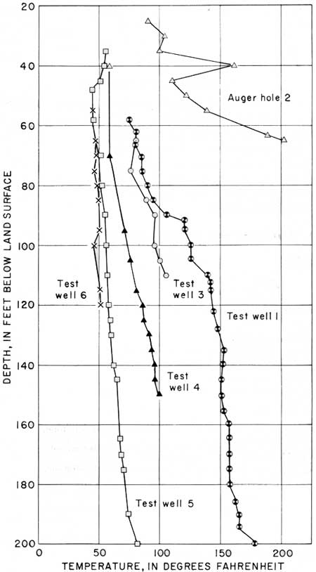
The principal water-bearing strata in the lacustrine deposits are the sand, sandstone, and conglomeratic gravel which in most wells were penetrated beneath the clay and silty clay. The temperature of the water in many of the test wells increased rapidly with depth; water from some of the test wells would have to be cooled before it could be used for drinking. The temperature gradients in 5 test wells and 1 auger hole are shown in figure 30.
|
| FIGURE 30.—Temperature gradients in test wells and auger hole at Grant Village site. |
| <<< Previous | <<< Contents >>> | Next >>> |
wsp/1475-F/sec2.htm
Last Updated: 28-Jul-2007