
|
Geological Survey Water-Supply Paper 1475-G
Water-Supply Possibilities at Capitol Reef National Monument, Utah |
WATER RESOURCES
SURFACE WATER
The Fremont River is the principal stream of the area, and its flow is perennial. Its flow is derived chiefly from melting snow on the Fish Lake plateau about 30 miles west of Fruita. Chemical analyses of water from the Fremont River are given in table 2. With proper precautions against bacterial contamination, this water probably could be taken directly from the river for use as a public supply.
TABLE 2.—Chemical analyses of water from selected sources in the headquarters area,
Capitol Reef National Monument, Utah
[Chemical constituents in parts per million]
| Source and location | Date of collection |
Specific conductance, in micromhos at 25° C |
Silica (SiO2) |
Iron (Fe) |
Calcium (Ca) |
Magnesium (Mg) |
Sodium and potassium (Na+K) | |
| Fremont River near Fruita | July 1, 1949 | 760 | -- | -- | 77 | 26 | 30 | 7.8 |
| Do | July 22, 1949 | 710 | -- | -- | 75 | 27 | 38 | 9.0 |
| Do | Aug. 31, 1949 | 720 | -- | -- | 74 | 25 | 28 | 10 |
| Do | Oct. 3, 1951 | 680 | 39 | 2.1 | 108 | 18 | 32 | |
| Do | Sept. 25, 1958 | 686 | 29 | -- | 79 | 27 | 32 | |
| Sulphur Creek near Fruita | Aug. 31, 1949 | 3,400 | -- | -- | 369 | 150 | 142 | 70 |
| Sulphur Creek near Park headquarters | Sept. 25, 1958 | 2,780 | 23 | -- | 371 | 182 | 125 | |
| Dewey Gifford Spring near Fruits | Oct. 3, 1951 | 1,275 | 43 | .2 | 215 | 32 | 70 | |
| Source and location | Bicarbonate (HCO3) |
Sulfate (SO4) |
Chloride (cl) |
Fluoride (F) |
Nitrate (NO3) |
Dissolved solids |
Hardness as CaCO2 | pH | Analyzed by— | |
| Calcium, magnesium |
Non- carbonate | |||||||||
| Fremont River near Fruita | 186 | 198 | 23 | -- | .2 | -- | 299 | 17 | -- | Atomic Energy Commission. |
| Do | 184 | 188 | 23 | -- | .4 | -- | 298 | 16 | -- | Do. |
| Do | 172 | 197 | 24 | -- | .1 | -- | 288 | 17 | -- | Do. |
| Do | 165 | 203 | 23 | .4 | 1.1 | 526 | 350 | -- | 8.2 | Utah State Department of Public Health |
| Do | 194 | 183 | 19 | -- | .8 | 465 | 307 | 148 | 7.3 | U.S. Geological Survey. |
| Sulphur Creek near Fruita | 175 | 1,890 | 111 | -- | .4 | -- | 1,540 | -- | -- | Atomic Energy Commission. |
| Sulphur Creek near Park headquarters | 197 | 1,640 | 55 | -- | .8 | 2,490 | 1,680 | 1,510 | 7.6 | U.S. Geological Survey. |
| Dewey Gifford Spring near Fruita | 232 | 513 | 35 | .5 | 1.8 | 1,050 | 680 | -- | 7.8 | Utah State Department of Public Health. |
The town of Fruita has no municipal water supply, but individual households obtain water for domestic use from the Fremont River and store it in cisterns. The water is chlorinated before use.
Sulphur Creek (pl. 15) is a perennial creek whose source is near the base of Thousand Lake Mountain, about 13 miles northwest of Fruita. Throughout much of its course this creek flows over the Moenkopi formation and as a result its water has a high sulfate content and is very hard. The chemical quality of water from this creek makes it undesirable for domestic use (table 2).
SPRINGS
Dewey Gifford Spring issues from the Moenkopi formation in the NW1/4 sec. 23, T. 29 S., R. 6 E. and is reported to flow 10 gpm. A chemical analysis of the water from this spring is given in table 2. Another spring issues from the Navajo sandstone in the NW1/4 sec. 14, T. 29 S., R. 6 E. It is likely that other small springs issue from the Navajo sandstone. No springs are known to issue from the Coconino sandstone in this area.
WELLS IN ALLUVIUM
Alluvium occurs along Sulphur Creek and along the Fremont River in the vicinity of Fruita. This alluvium consists principally of fine-grained detritus derived from the shales of the Moenkopi and Chinle formations. Some boulders and gravel occur in the alluvium, but these are mixed with the finer-grained material. It is unlikely that an adequate water supply for the monument could be developed from this body of alluvium owing to its fine-grained character. However, there are no wells in the alluvium, and its water-bearing properties perhaps should be tested before other sources of water are investigated. Water occurring in the alluvium along Sulphur Creek would probably be unsuitable in chemical quality (table 2); however, water occurring in the alluvium below the junction of Sulphur Creek and the Fremont River may be acceptable for a public supply.
WELLS IN BEDROCK
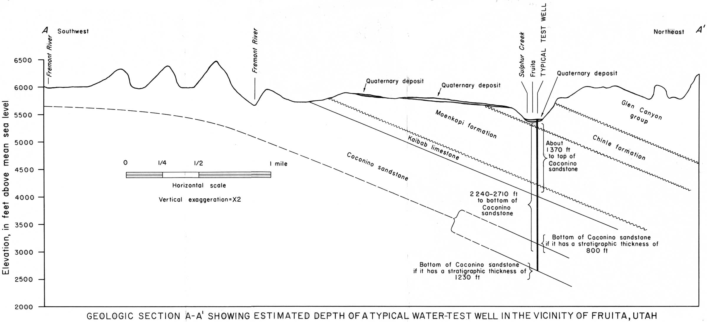
No wells have been drilled into the bedrock within the area of this investigation. Outside of the area most of the deep wells were drilled as tests for oil and gas and do not yield significant information about the quantity or quality of water reached. On the basis of the surface geology and hydrologic conditions, the Coconino sandstone might be expected to yield about 50 gpm—the quantity of water desired. Although it is very fine to fine grained, and hence of low primary permeability, the Coconino sandstone is fractured in many places (J. F. Smith, Jr., written communication, 1959), with the result that it may be relatively permeable. At the town of Fruita, the depth to the top of the Coconino sandstone should be about 1,370 feet below the surface, and it should have a thickness greater than 800 feet and perhaps as much as 1,230 feet (pl. 16). The water level in a well at this location should be near the land surface. The well may even flow naturally.
|
| PLATE 16.—GEOLOGIC SECTION A-A' SHOWING ESTIMATED DEPTH OF A TYPICAL WATER-TEST WELL IN THE VICINITY OF FRUITA, UTAH. (click on image for an enlargement in a new window) |
If a test well is drilled into the Coconino sandstone, the overlying Kaibab limestone should be tested by the same well. It is unlikely that the Kaibab limestone alone would yield sufficient water to supply the monument. However, water from the Kaibab limestone might make a significant addition to a supply developed primarily from the Coconino sandstone.
The principal recharge to this aquifer probably comes from the Fremont River and to a smaller extent from Sulphur Creek. Both streams flow across extensive areas in which the Coconino sandstone forms the streambed (pl. 15). J. F. Smith, Jr., who was in charge of the geologic mapping of this area for the U.S. Geological Survey, reports (written communication, 1959) that fractures in the Coconino sandstone are particularly numerous along the Fremont River canyon west of Fruita. The presence of fractures should facilitate any recharge from the Fremont River into the Coconino sandstone in this area.
The quality of water from the Coconino sandstone in this area is unknown. However, the chemical analyses of the two recharge sources (Fremont River and Sulphur Creek) are given in table 2. The Coconino sandstone is not as extensively exposed in the streambed of Sulphur Creek as it is in the streambed of the Fremont River. Therefore, the Fremont River should be a more important source of recharge than Sulphur Creek, and the quality of the water from the Coconino sandstone, except as it is modified by passing through the formation, should be more nearly like that of the Fremont River than that of Sulphur Creek. A chemical analysis of a representative rock sample of the Coconino sandstone showed that its composition was as follows:
Chemical analysis of sample of the Coconino sandstone
[Source: J. F. Smith, Jr. (written communication, 1959)
| Percent | Percent | Percent | |||
| SiO2 | 98.4 | CaO | 0.04 | P2O3 | 0.02 |
| Al2O3 | 1.0 | Na2O | .12 | MnO | .00 |
| Fe2O3 | .12 | K2O | .08 | H2O | .25 |
| FeO | .00 | TiO2 | .04 | C2O | .05 |
| MgO | .06 |
Water passing through rock of this composition from the Fremont River to Fruita, a distance of 1 to 2 miles, should remain reasonably potable. It is recommended that a test-well site be selected in Fruita rather than at the monument headquarters. The Fruita vicinity is directly downdip from the Fremont River, and recharge is more apt to come from the Fremont River than from Sulphur Creek.
| <<< Previous | <<< Contents >>> | Next >>> |
wsp/1475-G/sec2.htm
Last Updated: 28-Jul-2007