|
|
|
HAWAII NATURE NOTES
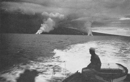
THE 1949 AND 1950 ERUPTIONS OF MAUNA LOA On June 1, 1950, almost exactly one year after the end of the 1949 eruption, Mauna Loa again broke into activity. At 9:04 p.m. a fissure 1.5 miles long opened along the southwest rift zone above 11,000 feet altitude. Floods of very liquid lava poured from the fissure, and a great mushroom-shaped cloud of gas rose two miles into the air, brightly illuminated by the red glare of the lava beneath, and looking much like the great cloud made by the atomic bomb explosion at Bikini. This activity lasted only about four hours. At 10:15 a new series of fissures started to open lower on the rift, between 8,000 and 10,500 feet altitude, and activity at these new vents replaced that nearer the summit. Big lava flows poured both westward and southeastward from the fissures. The lava was very fluid and flowed down the steep western slopes of the mountain with great speed (Plate 4). The first western flow advanced with an average speed of nearly 6 miles an hour, and at 12:30 reached the main highway around the island, destroying part of a village. At 1:02 a.m. on June 2 it entered the ocean. Two more western flows reached the ocean on the afternoon of the same day, the first at 12:04 and the second at 3:30. Where the lava entered the sea the water boiled, many fish were killed, and great billowing clouds of steam rose 10,000 feet into the air (see Frontispiece). The eruption continued with gradually abating strength until June 23.
The 1950 eruption of Mauna Loa was the greatest since 1859. Although no lives were lost it destroyed about two dozen buildings, and buried more than a mile of highway. Its six major lava flows contain on the order of a billion tons of lava. The 1949 eruption of Mauna Loa began late on the afternoon of January 6. Lava broke out along a series of fissures which crossed Mokuaweoweo caldera and extended 1.7 miles down the southwest rift. During the opening hours of activity a flow extended 6 miles down the western flank of the mountain. Within 48 hours, however, all activity outside the caldera was over and the western flow was dead. Within three days activity was entirely confined to the southwestern edge of the caldera. Lava fountains spurting from the fissure grew gradually higher, until on January 23 they were reaching heights as great as 800 feet. A cone of pumice 1,500 feet across and 250 feet high was built, and a mile-long blanket of pumice extended leeward of the cone. More than half the caldera floor was flooded with new lava. South Pit, a pit crater adjoining Mokuaweoweo, was filled to overflowing with lava, which spilled out to form a flow four miles long on the southern flank of the mountain. Lava fountaining came to an end on February 5, but short periods of quiet overflow of lava occurred during February and March, and during April it became almost continuous. A small lava cone was built on the caldera floor east of the earlier cone, and much of the southern part of the caldera was again flooded with lava. The eruption ended late in May.
|
| <<< Previous | > Cover < | Next >>> |
http://www.nps.gov/hawaii-notes/vol4-2g.htm
24-Mar-2006