

|
SARATOGA National Historical Park |
 |
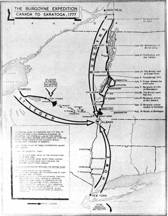
The Burgoyne Expedition, 1777
(click on image for an enlargement in a new window)
The British Plan of 1777
The Hudson River-Lake Champlain route for centuries has constituted a great strategic highway of the continent. Long the warpath of the powerful Iroquois, this route in pre-Revolutionary years had witnessed the ebb and flow of the tides of invasion as England and France locked in a titanic struggle for possession of the New World. Along this route the British commander, General Abercrombie, advanced in 1758 on his ill-fated attempt to seize Ticonderoga from the French. The graves of the "Black Watch" attest the blunders of his judgment. One year later his successor, Lord Amherst, followed the same route, to succeed where his predecessor had failed.
With the outbreak of the Revolutionary War the area again became the scene of active fighting, as colonial arms pushed boldly northward to seize Ticonderoga, Crown Point, and Montreal, and to storm the ramparts of Quebec. In 1776, the British launched a counterattack which, after wiping out most of the American gains, was dramatically checked by the gallant action of the American fleet under Gen. Benedict Arnold on Lake Champlain.
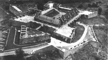
Fort Ticonderoga, the first object of Burgoyne
in 1777.
Courtesy Fort Ticonderoga Museum.
It was no idle chance that Britain, after 2 years of futile effort to coerce the colonies, should choose the Hudson-Champlain Valley as the route offering the greatest strategic possibilities for a quick suppression of the rebellion. Obviously, from a military standpoint, once control could be obtained of the ports and the narrow strip of coastal plain along the Atlantic seaboard, the backbone of the rebellion would be broken. By virtue of her seapower, England already had possession of the chief ports. Thus she was able to turn her attention to the second phase of her strategy. Of the 3 million American colonists, approximately three-fourths lived in the narrow border strip from Massachusetts to the northern boundary of Virginia. The key to this populous area was the Hudson-Champlain line. The dominance of this natural avenue of transportation would not only provide an effective barrier separating the New England States from the rest of the struggling colonists, but would remove any menace to the rear of the British armies operating offensively to the south. In control of this area Britain could then crush the separate armies in detail.
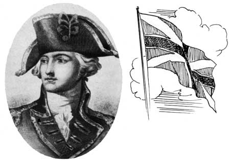
Lt. Gen. John Burgoyne, Commander of the
British Army which surrendered at Saratoga.
Courtesy U. S. Army.
The British plan was conceived by Gen. John Burgoyne and approved by the King and Cabinet. It called for a double advance along the Hudson in which the army of Burgoyne moving southward from Canada would effect a junction at Albany with the army of Sir William Howe moving northward from New York City, the two to be joined by Gen. Barry St. Leger moving eastward along the Mohawk from Oswego on Lake Ontario. That this strategy would succeed appeared certain, for against an American army composed chiefly of raw recruits—ill-disciplined and poorly equipped—were matched the seasoned veterans of the British forces, led by the foremost military commanders of the time.

|

| History | Links to the Past | National Park Service | Search | Contact |
|
Last Modified: Mon, Dec 2 2002 10:00:00 am PDT |