 | ||
 | ||
 | ||
 | ||
 | ||
 | ||
 | ||
 | ||
 | ||
 | ||
 | ||
 | ||
 | ||
 | ||
 | ||
 | ||
 |
 |
 |
George Washington Memorial Parkway
Virginia, Maryland, Washington, D.C.
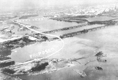
Proposed parkway route at Gravelly Point, beginning of dredge and fill operation, 1930 (NA) |
ENGINEERED FEATURES
The riverfront location helped cut down on intersections and offered excellent opportunities for park development, but it required the construction of numerous bridges and over two-and-a-half miles of artificial causeway. Large sections of the parkway near Hunting Creek and between Washington and National Airport are built entirely on landfill dredged from the bottom of the Potomac River.
Most of the original highway surface was composed of reinforced concrete slabs, but flexible asphalt was used on filled land to avoid cracking when the excavated material settled. In Alexandria, the concrete pavement was covered with blacktop. These distinctions can still be seen on today's parkway. The unstable fill also required innovative planting techniques and strongly braced bridge construction at Boundary Channel and other stream crossings.
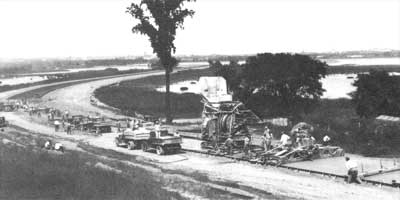
Paving near Capital Overlook, 1931 (NARA) |
PARKWAY BRIDGES
Most of the original parkway bridges were reinforced concrete structures faced with rough-cut stone for a more traditional appearance. Each bridge was given a slightly different design to accommodate local conditions and provide picturesque variety. This was standard procedure for parkway design in the 1920s-1930s. Railroad regulations stipulated steel construction, so parkway designers arched the railroad overpass's steel girders to harmonize with the other parkway bridges. The exposed concrete and steel spans of the parkway's later bridges exemplify modernist aesthetics and engineering concerns.
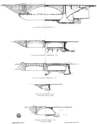
Illustration credits: historic photographs courtesy of National Archives and Records Administration (NARA), District of Columbia Public Library (DCL), and Commission of Fine Arts (CFA); HABS/HAER photographs by Jack Boucher, Jet Lowe and Timothy Davis; HAER bridge drawings by Michael Gala. |
| Introduction | Acadia | Blue Ridge Parkway | Colonial Parkway | Generals Highway | George Washington Memorial Parkway | Great Smoky Mountains | Mount Rainier | Rock Creek and Potomac Parkway | Shenandoah's Skyline Drive | Southwest Circle Tour | Vicksburg | Yellowstone | Yosemite | Discover History |
