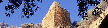
The ruined walls on the bluff situated at the
junction of the McElmo and Yellow Jacket Canyons are archeologically
instructive. As the mesa between the two canyons narrows in a
promontory, about 100 feet in altitude, its configuration reminds one of
the East Mesa of the Hopi. It is inaccessible on three sides, but on the
fourth, where the width of the mesa is contracted, there are remains of
a low zigzag wall, extending from one side to the other. At the western
base of this promontory, on the ledge higher than the river, there are
artificial walls built on bowlders in the sides of which shallow caves
are eroded and near by them circular depressions. There are likewise
remains of a small pueblo with walls much broken down and across the
river the ruins of a community house, one of the largest in the
district. The exceptional character of the ruins on top of this
promontory has been mentioned or described by several visitors, as
Holmes, Jackson, and Morley and Kidder, and various conjectures have
been made as to their character and relation to the other ruins in this
neighborhood.
The ruins on this mesa are of two kinds: small
inclosures made of slabs of stone set on edge and semicircular
structures (fig. 18), also constructed of upright stone slabs or
megaliths. Three of the latter have concentric surrounding walls with a
"vestibule" entrance (?) at the south somewhat like rooms at the bases
of towers. One of these is said by Morley and Kidder to have three
concentric walls. The small box-like structures are numerous, and are
rudely constructed, united in an imperfect ring about the circular
rooms.

FIG. 18.—Megalithic stone inclosure, McElmo Bluff.
|
In verification of the various theories that have
been suggested to account for these rectangular structures—their
interpretation as storage bins, burial places, and cremation
rooms—we have no proof. Similar rooms of megaliths
exist on Sandstone Canyon and at other places to the
north and in Montezuma Canyon to the west. The rude,
massive character of the masonry leads me to refer
them to the slab-house culture of Kidder and the imperfect
masonry suggests they were habitations in a period antedating
that of the pure pueblo culture. Such fragments of pottery as were
found were, like the architecture, rude and archaic, adding weight to
the interpretation that they belonged to a very old epoch.
The author regards the structures made of stones set
on edge as very old, possibly examples of the most
primitive buildings in the McElmo region, antedating the pueblos with
horizontal masonry farther east. West of the mouth of the Yellow Jacket,
especially on the Montezuma Mesa, these megalithic walls are more
pretentious, as if this was the center of the earlier phase of house
buildings. In the eastern ruins these slabs of stone set on edge
sometimes appear as at Far View House with horizontal masonry, but more
as a survival.
Since their discovery and description by Jackson and
Holmes 40 years ago, little has been added to our knowledge of these
inclosures, although similar remains have been reported at various
points from Dolores far into Utah. They are called cemeteries and
crematories by the farmers and stockmen, but skeletons or burnt bones do not
occur in them; the charcoal shows wood fiber, and is not bone ash. More
knowledge must be obtained through excavations before
their significance can be determined. Their
association with circular rooms appears in Jackson's account [1]
of the stone structures on the promontory at the mouth of the
Yellow Jacket. He says:
1Tenth Ann. Rept. U. S. Geol. Surv. (Hayden Survey) for 1876, p. 414,
1879.
"The perpendicular scarp of the mesa ran round very
regularly, 50 to 100 feet in height, the talus sloping down at a steep
angle. On cave like benches at the foot of the scarp is a row of rock
shelters, much ruined, in one of which was found a very perfect
polished-stone implement. Gaining the top of the mesa with some
difficulty, we found a perfectly flat surface, 100 yards in width by
about 200 in length, separated from the main plateau by a narrow neck,
across which a wall had been thrown, but which is now nearly leveled.
Almost the entire space fenced in by this wall was covered by an
extended series of small squares, formed by thin slabs of sand-rock set
on end. All were uniform in size, measuring about 3 by 5 feet, and
arranged in rows, two and three deep, adjusted to various points of the
compass. There were also a few circles disposed irregularly about the
inclosed area, each about 20 feet in diameter, their circumferences
being formed of similar rectangular spaces, leaving a circular space of
10 feet diameter in the center. These rectangles occur mainly in groups,
and are found indiscriminately scattered through the whole region that
has come under our observation upon the mesa tops and in the valleys.
They all have the same general shape and size, and are seldom
accompanied by even the faintest indication of a mound-like character.
We have always supposed them to be graves, but have not as yet found any
evidence that would prove them such. Some that we excavated to the depth
of 5 and 6 feet in a solid earth that had never been disturbed did not
reward our search with the faintest vestige of human remains. In nearly
every case, however, a thin scattered layer of bits of charcoal was
found from 6 to 18 inches beneath the surface. In one instance, near the
Mesa Verde, the upright slabs of rock which inclosed one of these
rectangles were sunk 2 feet into the earth and projected 6 inches above
it."
Holmes (op. cit., pp. 385-386) describes similar
structures:
"The greater portion of what are supposed to be
burial places occur on the summits of hills or on high, barren
promontories that overlook the valleys and canons. In these places
considerable areas, amounting in some cases to half an acre or more, are
thickly set with rows of stone slabs, which are set in the ground and
arranged in circles or parallelograms of greatly varying dimensions. At
first sight the idea of a cemetery is suggested, although on examination
it is found that the soil upon the solid rock surfaces is but a few
inches deep, or if deeper, so compact that with the best implements it is very
difficult to penetrate it.
"On the west bank of the Dolores, near the second bend, I came upon a
cluster of these standing stones on the summit of a low, rounded hill,
and in the midst of a dense growth of full-grown pinon pines."
The rows of stones at this place, according to the
same author, were composed of undressed slabs, many of which had fallen,
the parallelograms averaging 3 by 8 feet in dimensions. Thin layers of
bits of charcoal and pottery occur in the neighborhood. The date these
slabs were placed upright was very early, for trees growing in the
inclosures were estimated to be three or four hundred years old. These
stones were sometimes "embedded in the sides and roots of the trees."
Holmes had the "impression that these places, if not actually burying
grounds, were at least places used for the performance of funeral rites
. . . the remains of the dead being burned or left to decay in the open
air."
The interiors of the inclosures were found on
excavation to be filled to a depth of about a foot with soil mixed with
ashes. There were many fragments of pottery, and some other objects near
them, but nothing to indicate, as suggested by previous observations,
that they were burial cists or even crematories for burying the dead. No
charred human remains occur, but charcoal is abundant. It may have been
that these places were used as ovens for roasting corn or for some
culinary purposes, the neighboring circular rooms being possibly used
for the same purposes as towers by the people who formerly inhabited
this region. They are not large enough for dwellings and the soil in
them is too shallow for burial purposes. They belong to a type which is
widely distributed over the district visited by the author. Especially
fine examples occur north of Sandstone Canyon district.
At the base of the great cliff, on the top of which
the remains in question are found, under the shelter of an overhanging
bowlder, may be seen one of the finest collections of pictographs of
animals and human beings. Not far from the last-mentioned bowlder the
walls of a large pueblo can readily be traced along the banks of the
McElmo Canyon. In his studies of the antiquities of this region the
author did not penetrate west of the mouth of Yellow Jacket Canyon, but
he was told by stockmen and sheep herders of the existence of many other
ruins contiguous to the road all the way from this point to Bluff City.
The most important of these have already been described in a general
way.