


Historical Background
| July 3-26 1806 |
Lewis follows the shortcut to the Great Falls
Lewis, the nine men, five Nez Perce guides, and 17 horses traveled north down along the Bitterroot River about 10 miles, moved eastward along the Missoula-Hellgate Rivers, and bivouacked that night at a point a mile or two to the east of the present city of Missoula. [135] The next day, on July 4, the guides, who considered the Hellgate area and region to the east a dangerous place because Blackfeet war parties frequented it, said they would go no farther and expressed concern for the safety of the Lewis party. They planned to ascend the Clark Fork to visit a friendly tribe and then return over the Lolo Trail to their homeland. They said the branch of the buffalo road that was being followed eastward would continue to be clearly visible and later run along the Big Blackfoot River, which they called the "River of the Road to Buffaloe." Lewis, who deeply appreciated their services, smoked the pipe with them, gave them some meat, and said goodbye.
Lewis and his men, proceeding onward, entered Hellgate Canyon, followed it eastward to the Big Blackfoot River, and moved along the well-marked road. Evidences of a large Blackfeet war party and abandoned camps caused the commander to bolster security. On July 7, at a point about 45 miles northwest of present Helena, the Continental Divide was crossed and the Louisiana Territory and the United States reentered via a pass that came to be known as Lewis and Clark Pass—though Clark never saw it.
The next day, the first buffalo on the return trip were viewed. Busy pursuing them and other game, Lewis bypassed the Dearborn River route to the Missouri and detoured northward to the Sun River, which he descended to the Missouri, and on July 11 arrived opposite the upper portage camp of the year before. Some 8 days had been required to come from Travelers Rest to the Great Falls area—3 more than the Nez Perce guides had said was necessary, but the hunting detour probably accounted for the difference.
The men set to work building a round Mandan-style bull boat, stretching a buffalo hide over a timber framework, and fashioned a canoe covered with two other hides. On the evening of the 12th, the party with its baggage crossed in the boats to the south side of the Missouri, swimming the horses across. The next day, it moved to the upper portage camp.
The grizzlies, rattlers, and prickly pear in the area were found to be as abundant and troublesome as before. The grizzlies, as well as big timber, or lobo, wolves, which howled continuously day and night, feasted on buffalo. When the year-old cache at the upper portage camp was opened, it was discovered that the river had risen so high that water had entered it, destroying all the plant specimens and bearskins and dampening some of the papers and articles. A stopper had come out of one of the medicine bottles, spoiling most of the other medicines.
The next day, the 14th, the wagon wheels and the framework of the "Experiment" were dug up and found to be in fairly good condition. The following afternoon, Drouillard, who for several days had been searching on the north side of the Missouri for seven horses that had disappeared before the crossing was made to the south side, came into camp. Lewis, who had given him up as lost to a grizzly, was happy to see him again but sorry to learn that he had pursued but failed to catch the Indians who had stolen the animals.
Only 10 horses remaining, Lewis had little choice but to alter his plans for the Marias exploration. He reduced the number of men from six to three and chose the three woodsmen best equipped to meet any emergency: Drouillard and the Field brothers. They would take six horses and leave four with Sergeant Gass and his five men. [136] The latter group was to wait at the upper portage camp until the arrival of Sergeant Ordway and the nine men from Clark's party with the canoes. Then they were jointly to portage the canoes and baggage around the Great Falls, recover the white pirogue and supplies cached at the lower portage camp, and proceed downriver to the mouth of the Marias to meet Lewis. Lewis, who expected to be back there by August 5 if he did not meet some misfortune, instructed Gass to wait until September 1 before moving down to the mouth of the Yellowstone and reuniting with Clark's party.
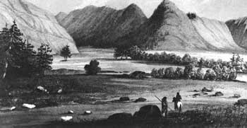 |
| Artist's rendition in the mid-1850's of Hellgate, the defile where the river of the same name cuts a passage through a spur of mountains near present Missoula, Mont. Lewis and his party passed through the region in July 1806 en route to the Marias River on the return from the Pacific. (Lithograph by Sarony, Major & Knapp from a sketch by Stanley, in U.S. Pacific Railroad Surveys, XII, Plate LXIV.) |
Lewis explores the Upper Marias
On July 16 Drouillard and Reuben Field set out from the upper portage camp with the six horses, which they swam across the Missouri above the White Bear Islands to the lower side of the Sun River. Lewis and Joseph Field, transporting the baggage in the canoe, moved down the Missouri to that point. After abandoning the boat, the four men swam the mounts across the Sun, and spent the night along the Great Falls. The water was lower than the year before but the falls were still, in Lewis' words, a "sublimely grand object."
With the rising sun, the explorers pushed northward over plains resembling an ocean. They arrived the following evening, the 18th, at the Marias, well up from the mouth. They knew they were in the Blackfeet heartland and maintained a vigilant day and night watch. On the afternoon of the 21st, the river forked into a northern branch, Cut Bank Creek, and a southern one, Two Medicine River. Beginning to fear that the Marias system did not extend as far north as he had hoped, to 49° or preferably 50° latitude, Lewis moved some 28 miles up Cut Bank Creek.
On July 22 camp was made about 12 miles northeast of present Browning, Mont., in a beautiful bottom about 20 miles from the foot of the Rockies. In the distance, Lewis saw that the creek curved toward the mountains to his southwest, and knew he had reached the northernmost point of the Marias system. He decided to stay for awhile at this site, which he called Camp Disappointment, to rest the horses and men and make geographical and astronomical observations. This camp was the northernmost of the expedition and only a few miles west of the place on Cut Bank Creek that represented the northernmost point attained.
Drouillard, on his commander's instructions, the next day, the 23d, proceeded up Cut Bank Creek and confirmed Lewis' visual judgment. He brought back disquieting news. He had discovered a 10-day-old abandoned camp of 11 lodges. Blackfeet, with whom Lewis wished to "avoid an interview," must be near! For the next 2 days the weather was so rainy, windy, and cloudy that he was unable to make instrument observations and thus could not determine the latitude (48°40' N.). The same conditions prevailing on the morning of the 26th, he decided he could wait no longer to begin the trip back to the Missouri. He and the three men struck out southward, crossed Two Medicine River to its south side, and began to follow it downstream.
 |
http://www.cr.nps.gov/history/online_books/lewisandclark/intro55.htm
Last Updated: 22-Feb-2004