|
MOUNT RAINIER
Master Plan Preliminary |

|
THE PLAN
|
PURPOSE THE PURPOSE OF MOUNT RAINIER NATIONAL PARK IS TO PROTECT, PRESERVE, AND INTERPRET THE NATURAL, SCENIC, AND HISTORICAL RESOURCES OF THE PARK FOR THE BENEFIT AND APPRECIATION OF THE PEOPLE. MANAGEMENT CATEGORY THE PARK WILL BE MANAGED ACCORDING TO THE ADMINISTRATIVE POLICIES FOR NATURAL AREAS OF THE NATIONAL PARK SYSTEM. |
VISITOR USE AND DEVELOPMENT
Planning Approach
Since the park's establishment in 1899, the type and intensity of visitor use has changed dramatically. From a remote spa-like resort, attracting a select group of people from a much smaller population, it has changed to a heavily-used scenic area within easy access of a large metropolitan area.
Development within the park reflects these changing and increasing use patterns. Today, with two million people visiting the park annually, there are demands being made upon existing visitor-use facilities that are beyond existing capacity. Inevitably these demands will become even greater in the future.
Space to provide additional development inside the park is severely limited by terrain and environmental conditions. In a few instances, existing development, mainly roads and parking areas, has had unwelcome effects upon the resource and visitor experience.
This plan proposes a redirection of use and its associated development according to the ability of the resource to absorb its impact. Of primary importance is the removal of development and activities that serve nonessential visitor and management needs from prime resource areas of the park. These activities and facilities should be located at more appropriate places within existing developed areas or, if possible, outside the park. No new developed areas are proposed.
|
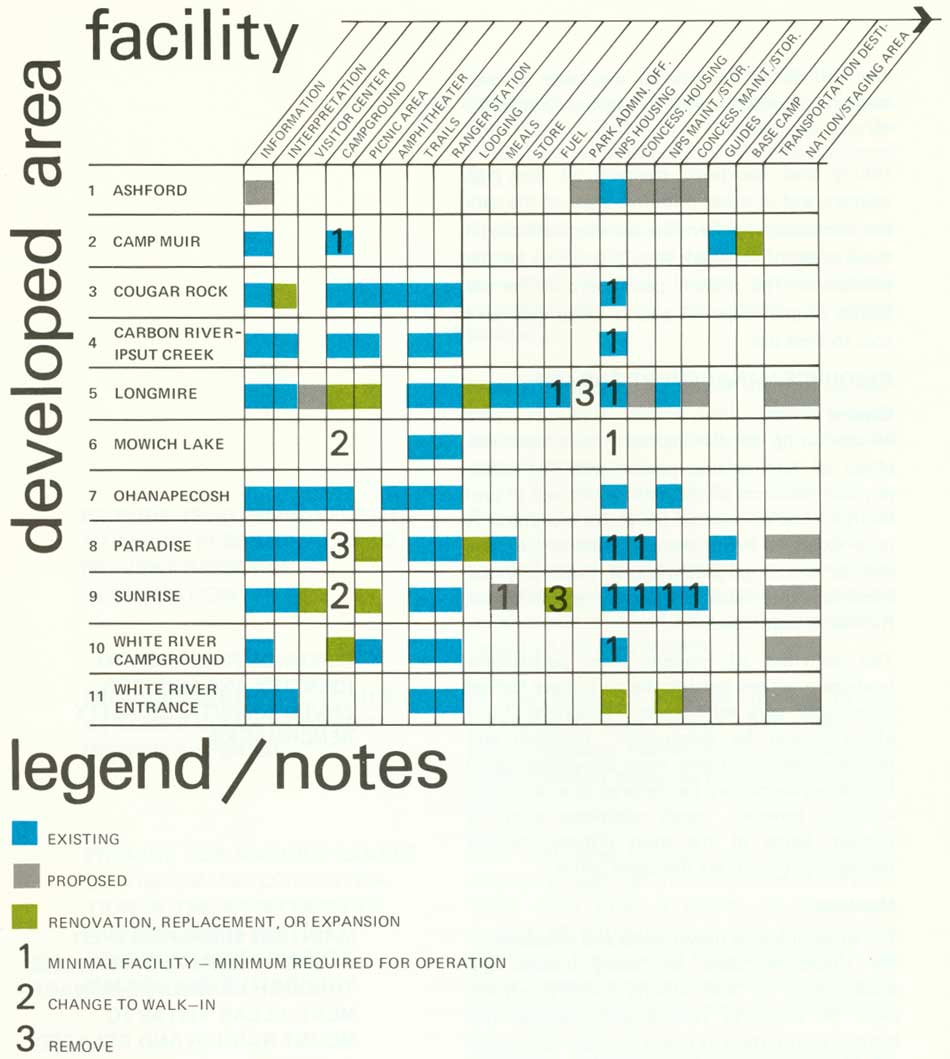
| Developed Area/Facility. (click on image for an enlargement in a new window) |
Unfettered with extraneous uses and activities, each developed area will be able to provide a richer resource-related experience to more visitors.
When development is required to replace that which becomes obsolete or to accept relocated activities, efforts should be made to concentrate it within the smallest possible space consistent with enhancing the natural, esthetic, and social environment.
The re-structuring of use and development as proposed in this plan will be a continuing process, and is subject to continuous review and amendment. In an effort to provide the best possible experience to the broadest possible spectrum of people, management will become aware of changing trends in visitor needs and uses. As a result of research and observation, management will become aware of improvement or degradation in the natural, esthetic, and social environments in the various areas of the park. These trends will determine a re-arrangement in priorities, and re-structuring in specific areas will vary accordingly.
|
OBJECTIVES: OPERATE THE PARK ON A YEAR-ROUND BASIS, PROVIDING VISITOR SERVICES AT A LEVEL COMMENSURATE WITH SEASONAL DEMAND AND AT PLACES WHERE CLIMATIC CONDITIONS ALLOW. PROVIDE FOR VISITOR USE BASED ON RESOURCE APPRECIATION VALUES AND SOCIAL FACTORS, WHILE ENSURING MAINTENANCE OF A QUALITY ENVIRONMENT. CONTINUE WINTER RECREATION USE AT PARADISE AND PROVIDE FOR OTHER WINTER USE WHERE ECOLOGICALLY AND ESTHETICALLY COMPATIBLE. |
The following changes are recommended:
Paradise
The brilliant wild flower displays during the summer and the spectacular view of Mount Rainier and mountain ranges have historically attracted large numbers of people to Paradise. It will undoubtedly remain a strong attraction in the years to come. Opportunities exist here to introduce large numbers of people to the forces of nature in and around Paradise. It is possible to concentrate interpretive and resource management efforts to ensure a quality experience.
Although it is possible to provide use for the large number of people, it is not possible to accommodate the large volume of automobiles that are virtually the only means of access to Paradise. Parking lot size is simply too small to serve present needs on busy weekends. Increasing visitation will compound existing deficiencies. It is not practical to increase parking lot size, as the capacity of park roads serving it would soon be exceeded. Furthermore, increasing the parking area size and increasing road capacity would have unacceptable impact upon the resource and the visitor experience.
An alternate method of getting people to Paradise must be found. A transportation study is required to determine the exact methods required to satisfy present and future needs. Caution is necessary in determining alternate transportation methods. Visitor acceptance and resource preservation must be considered. As an interim solution, this plan proposes a bus system between Longmire and Paradise to be concessioner-operated on peak-use days during the summer. Hopefully, a long-term solution to transportation can be found that would operate park-wide and totally eliminate the automobile.
|
REMOVE CAMPGROUNDS FROM HIGHER, MORE FRAGILE AREAS OF THE PARK. |
The campground should be removed. The small amount of use it receives due to the short, snow-free season does not justify the intrusion it imposes upon the natural environment and upon the visitor experience. The land should be restored to meadow.
Overnight accommodations at Paradise should be allowed to expand within the space presently occupied by Paradise Lodge and its immediate vicinity.
|
DESIGN ALL FACILITIES TO COMPLEMENT NATURAL LAND FORMS AND VEGETATIVE COVER. |
Park Service administrative facilities and housing and concessioner housing, not essential for serving the visitor, should be relocated. Circulation within the Paradise area will be limited to paved trails. Picnicking will be restricted and concentrated to minimize degradation of the fragile higher scenic meadowlands. Winter recreation activity will continue, with emphasis upon ski and snowshoe touring.
Sunrise
Increased emphasis should be placed upon visitor use at Sunrise. Here, as at Paradise, concentrated visitor use of the fragile Hudsonian zone is provided. Increasing resource oriented opportunities here will allow increased visitor use and enjoyment of the park without endangering the resource. It is hoped to eventually remove the automobile completely, for preservation of superlative resource values, and thereby benefit the visitor's experience.
A tram or similar device would provide access from a transportation terminal located at a lower elevation adjacent to existing roads outside of the Sunrise area. When such a system is inaugurated, it will be possible to reduce the present access road to a secondary status or to close it completely. Hopefully the present road cut can be restored to a natural condition and some of the intrusion it now imposes upon the mountainside will be removed.
The upper tram terminal would become a multi-purpose building replacing all existing structures as they become obsolete. The campground would be retained, although access would be by foot. Consideration should be given to operating Sunrise on a year-round basis, once a tram provides visitor access and logistics.
It may be necessary to await advancement in technology in order to implement a mass transit system. However, no further development to accommodate the automobile should be planned.
Longmire
Longmire, located in the lower forested area of the park, has historically been the administrative center of the park and a stopping place for visitors. With the development of visitor-use facilities in the other areas of the park, this area has evolved to serve primarily as an administrative center. This trend is now being reversed. Park administrative offices, maintenance shops, and housing will be located outside the park at Ashford. Only those facilities necessary for onsite operation will remain at Longmire. Facilities and activities relocated from Paradise will be accommodated at Longmire. Longmire can also serve as a transit terminal for the interim bus transit system to Paradise.
Carbon River-Ipsut Creek
This unique resource area of the park is particularly appropriate for the immediate implementation of a visitor circulation system using vehicles other than automobiles. Unlike the loop road accesses to the heavily visited areas of the park, access to this area is by dead-end road.
Foot, bicycle, and possibly a mini-bus will provide access through the Carbon River rain forest, and to the Ipsut Creek area, from a parking area at the park boundary. In other respects this area will function as at present.
Mowich Lake
Removal of the automobiles from the vicinity of this highly scenic area would greatly increase the quality of the visitor experience. Although implementation of alternate methods of visitor access is not as simple as at Carbon River-Ipsut Creek, efforts should be made to keep automobiles as far from the lake as possible. Consideration should be given to ending the road at the park boundary and using leased parking space on private land outside.
Camp Muir
Camp Muir has historically served as the overnight staging area for those who climb the mountain. Within the last decade, attempts to climb Mount Rainier have increased three-fold and will no doubt continue. This use has put heavy demands upon facilities. Present facilities are obsolete and inadequate to meet present needs. They should be removed, and be replaced by a structure harmonizing with the rugged character of both the landform and the visitor experience. This structure should provide minimal services to accommodate all climber and management needs in a manner compatible with the rugged climbing experience. As in all high rocky areas, sanitation and disposal of wastes is difficult. Effort should continue to keep solid wastes to a minimum and to find more efficient methods for disposal of all wastes. Logistics should be as dependent as possible upon the climbers and less dependent on the helicopter.
Ohanapecosh
The campground and other visitor-use facilities here provide excellent opportunity to experience the successional Douglas-fir forest of the humid transition vegetative zone. Development and the use it generates are compatible with resource values.
Cougar Rock
The picnic area and campground at Cougar Rock also provide opportunity to experience the lower forested areas of Mount Rainier.
White River
The campground is located within the upper fringes of the forested area of the park, and trails from here lead immediately into the meadow areas of the Hudsonian zone. It will remain as the most remote of the park's established campgrounds. With the implementation of a transportation system, consideration should be given to restricting automobile use of this area.
The ranger station and entrance station area is in need of rehabilitation. A new facility serving present functions should be provided in a location that will better serve the visitor.
Roads and Trails
Two-lane State highways, through agricultural and timber lands and small towns, lead from urban areas and interstate highways to the park. Scenic park roads, augmented with a through-State road, offer a loop trip through the park and adjacent national forest lands, and provide primary access to major developed areas. Orientation to the opportunities available within the park is offered at entrance stations on park roads.
In order to provide for greater visitor enjoyment of the park, changes in the present road system are proposed. The West Side Road should be closed to vehicular traffic at Klapatche Point. This would enable a large portion of the west side of the park to be enjoyed by the increasing number of hikers and backcountry users without the intrusion of the automobile. Parking space would be provided at the new road terminus, and the abandoned portion of the road converted to trail status.
Parking space would also be provided at park boundaries along access roads to Carbon River-Ipsut Creek and Mowich Lake. The present road to Mowich Lake would be converted to a trail.
Upon the implementation of alternate means of access to Sunrise, the present road will be converted to the lowest possible status commensurate with the means of access selected.
It may be possible to convert the road to foot- and ski-trail status and thereby allow landscaping measures to be taken to reduce the esthetic intrusion.
|
PROVIDE TRAIL IMPROVEMENTS AT ALPINE FLOWER FIELDS TO PREVENT RESOURCE DEGRADATION. PROVIDE ADDITIONAL TRAILS AT LOWER ELEVATIONS FOR VISITOR DISPERSAL. PROVIDE FOR VARIOUS LEVELS OF VISITOR-USE CONCENTRATION IN THE BACKCOUNTRY, ACCORDING TO VISITOR RESOURCE APPRECIATION VALUES AND SUITABILITY. |
The method of mass transit access to Sunrise will determine where associated visitor parking will be located. Strong emphasis must be placed upon selecting a transit system and parking terminal site that will have the lowest possible impact on the environment.
In the future, it may be feasible to use interpretive mass transit throughout the park — removing visitors from their cars, and freeing them to enjoy the park throughout their visit.
Over 300 miles of foot trails provide access through virtually all the ecosystems of the park. These trails offer a variety of experiences, degrees of difficulty, and time requirements. Additional trails should be provided within the lower forested areas of the park in response to existing and proposed visitor use of those areas.
Additions, deletions, and improvements in the trail system will be required from time to time to promote proper visitor dispersal and to protect resource values. The present policy of paving trails at Paradise may require the initiation of visitor educational measures or even outright physical barriers to prevent foot traffic through meadows.
Hiking and backpack camping in the high country and in other primitive areas of the park are increasing rapidly. The carrying capacity in these areas of the park should be given further evaluation. The present permit system for use allows proper dispersal and is being used as a tool to limit use.
|
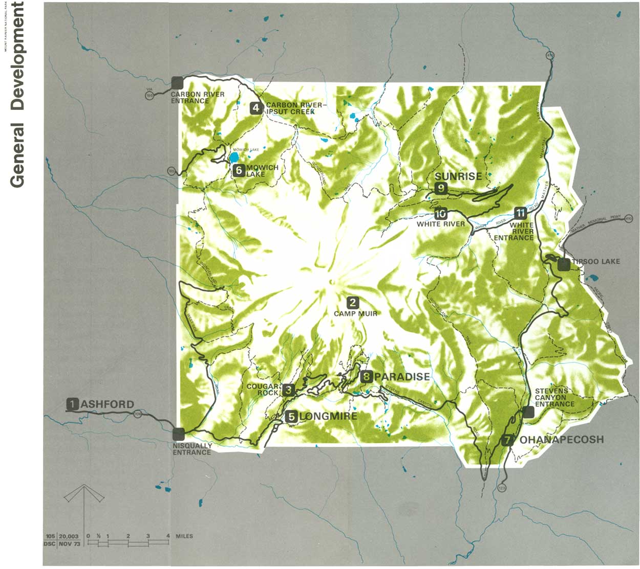
| General Development. (click on image for an enlargement in a new window) |
RESOURCE MANAGEMENT AND USE
General
Re-structuring of development will have the effect of familiarizing people with the prime physical resources of the park, which will in turn result in less damage to the prime resources. A need exists to repair damage done in the past and to ensure perpetuation of those physical resources that have historically given Mount Rainier its significance.
The activities of modern man, particularly land-use practices outside the park, have had an effect upon park ecosystems. The extent of this effect should be determined. Research and general observation give some knowledge about how ecosystems may be restored to ensure their viability; however, much additional study is needed. Some of the most critical resource management needs are discussed below.
Meadows
The subalpine wild flower fields and meadows of the Hudsonian zone are being invaded by subalpine-fir. In and around Paradise, efforts must be made to restore and preserve the historic distribution of plants in order to provide interpretation and visitor experience within the present impact area. In other areas of this zone, this invasion will be allowed to proceed naturally, correcting adverse influences introduced directly and indirectly by man.
|
CONTINUE RESEARCH TO IDENTIFY AND MONITOR ENVIRONMENTAL QUALITY BENCHMARKS. MAINTAIN SUBALPINE WILD FLOWER FIELDS AND MEADOWS THROUGH LANDSCAPE MANAGEMENT; CLEAR VISTAS TO MOUNT RAINIER AND RELATED SCENERY WHEN NECESSARY FOR VISITOR APPRECIATION; AND ALSO PREVENT RESOURCE DEGRADATION CAUSED BY ADVERSE VISITOR USE. EMPHASIZE RESEARCH TO DETERMINE NATURAL PHENOMENA THAT AFFECT PLANT SUCCESSION. |
Lower Forested Areas
The forest mosaic within these areas is determined by dynamic successional processes. The predominance of Douglas-fir, a subclimax species within the Transitional zone, has been the result of periodic opening of the forest canopy by blowdowns, mudflows, insect attacks, slides, and especially fire. The present policy of immediate suppression of all fires in these areas is mandated by the catastrophic potential to destroy prime resource areas that have existed within the park for decades and to cause severe economic hardship should fire escape to land outside the park. Man-caused fires and wildfires do open the forest canopy somewhat before suppression, even under present policy. Continuing research is needed to determine if this policy is detrimental to the overall forest mosaic, and if it is, to determine other methods to ensure perpetuation of plant community viability.
Insects and Disease
In all natural ecosystems, insects and disease exert their influence. They should be allowed to continue this influence without interference by man. Artificial controls should be used only in the event that an epidemic attack threatens an entire ecosystem within the park, or when an infestation from within the park presents a potential damaging effect to outside forests.
Fish and Wildlife
The lakes within the park and the streams above natural barriers were probably naturally barren of fish. The low level of nutrients does not permit healthy propagation. Fish planting in these lakes will be discontinued, and they will be allowed to revert to their natural state.
To the extent possible, the indigenous species of wildlife and their habitat will be maintained in their natural condition. Natural predation will be allowed to control the populations. Special efforts should be made to allow visitors an opportunity to observe native species of wildlife in a natural environment.
|
DETERMINE SEASONAL RANGES AND MIGRATION PATTERNS OF ELK; DETERMINE HERDS' HEALTH AND SIZE; DETERMINE AREAS SUBJECT TO OVER-BROWSE; AND INITIATE MEASURES TO AMELIORATE ANY RESOURCE DAMAGE. ELIMINATE EXOTICS WHEN THEY POSE A THREAT TO INTRINSIC RESOURCE VALUES. |
If populations of migratory ungulates build up due to conditions outside the park, control measures will be taken to reduce their numbers to a level that will not adversely affect park vegetation and soil, or habits of other species of wildlife. In the case of elk, present research shall be continued and used to implement reduction and control of the elk population using the park for summer range. Controls will be carried out in cooperation with the Washington State Department of Game and the Forest Service.
Exotic Plants
Plants not indigenous to the park should be eliminated, or if this is impossible, kept to a minimum.
Much of the park is particularly appropriate for study by visitors, management, and educational and scientific institutions. Some of the most apparent areas for study include Burrough's Mountain arctic tundra area; Carbon River Rain Forest; and outstanding examples of the dynamic processes of volcanism, glaciation, and erosion. Other areas, including climax forests and unique plant communities, also offer exciting possibilities for cursory and detailed study.
Efforts should continue to make the results of these studies relevant to apparent needs.
Environmental study areas for use of local and regional school systems might be established, utilizing regular visitor-use areas and attendant facilities. Coordination among other State and Federal natural resource agencies and academic institutions could map out the scope of such a program.
Historical Resources
Evidence of prehistoric occupation of the area that is now the park has not been found. It is known that the mountain itself held religious significance for many of the tribes occupying land around the park; however, their use was probably confined to hunting and food gathering.
Man's use is evidenced in those structures still standing that served the needs of early non-Indian explorers and conservationists, and of the Government stewardship since the park was established. The Longmire Cabin is presently being preserved and interpreted to visitors. Other structures, including some of those at Longmire and Paradise, and the Superintendent's old office at the Nisqually entrance, warrant study to determine their significance and to direct preservation and future use.
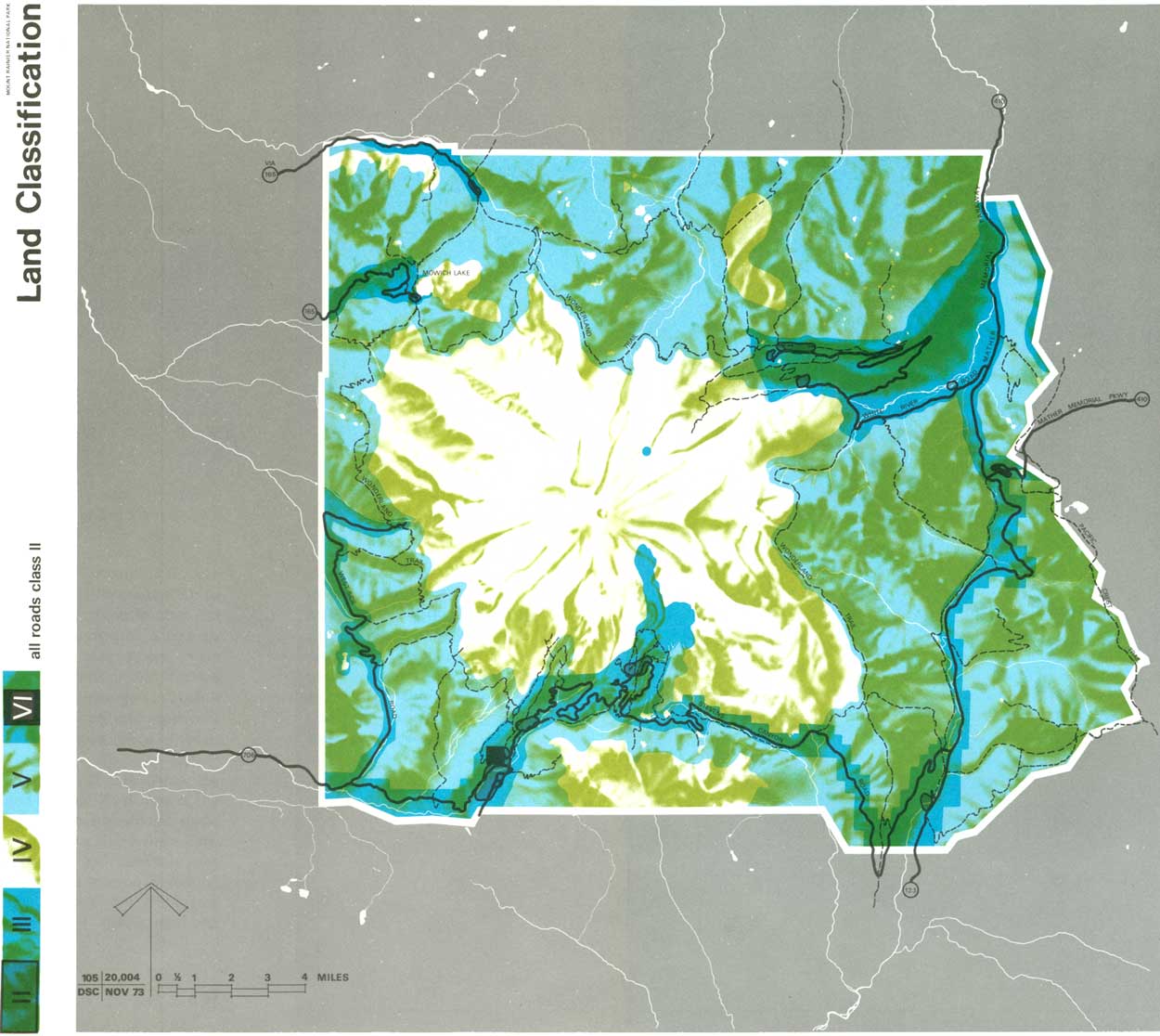
LAND CLASSIFICATION
Classification of park land is based on present Service policy, landscape features, and existing and proposed uses.
Class II, General Outdoor Recreation Areas
The major park-use areas and primary road system fall into this classification. The area included in this classification is sufficiently large to accommodate projected use.Class III, Natural Environment Areas
Minor roads, secondary-use areas, utility systems, buffer zones between Class II and Classes IV and V, and a 1/8-mile management zone along the park boundary where required are included in this classification.Class IV, Outstanding Natural Areas
This classification, embracing most of the park, includes the magnificent glacial system, alpine flower fields, and lush forests for which the park was established.Class V, Primitive Areas
All roadless and natural areas suitable for wilderness designation are included in this classification.Class VI, Historic and Cultural Sites
Only Longmire Meadow is included in this classification.
|
| Land Classification. (click on image for an enlargement in a new window) |
INTERPRETATION
The interpretive program should introduce visitors to the resources and encourage them to learn about and appreciate natural features and processes. The program should encourage visitors to go into the park to study and to see the beauty of the many components that are Mount Rainier. Visitors will be urged to observe how parts of natural systems are interdependent to all other parts, and that man is one of these.
|
INTRODUCE VISITORS TO THE RESOURCES OF THE PARK. ENCOURAGE THEM TO STUDY AND UNDERSTAND LIFE PROCESSES/NATURAL SYSTEMS, SO THAT THEY MAY BETTER APPRECIATE THE NATURAL WORLD OF WHICH THEY ARE A PART. |
The main interpretive themes throughout the park are geology and ecology. Evidences of the dynamic geological forces that create and shape the land are starkly obvious everywhere. The different aspects of geology and climate — such as volcanism, soil formation, erosion, glaciation, and outburst floods — will be interpreted at those places where the visitor can best appreciate each aspect. Likewise, ecosystems within various vegetative zones will be put in context with each other and then interpreted specifically. Climatic and other environmental factors that affect species domination should be explained, so that by learning about different life zones, visitors will be able to appreciate those factors that encourage differences.
Main interpretive efforts will be made at major developed areas and will stress introductory experiences. Those inside the prime resource area should provide experience in greater depth.
At Paradise and Sunrise, efforts should be made to tie all aspects of geology and ecology together. Some visitors will be encouraged to learn about resources in greater detail; others, who are familiar with the park, will be able to make conclusions.
In addition to the other interpretive duties assigned to Paradise, efforts should be made to assist visitors in gaining mental and physical skills that will enable them to deal with nature on nature's terms — to climb the mountain — to experience the backcountry.
At Sunrise, visitors are afforded spectacular views of Mount Rainier and Emmons Glacier, and expansive views of the landscape over ridges and river valleys. Interpretive opportunities are exceptional here. From Sunrise, visitors should be encouraged to use trails and experience a feeling of discovery. Implementation of tram-access would provide visitors with an interpretive trip through different life zones, adding even more to the rewards of a visit here.
At Longmire, human history will be an interpretive subtheme. The main thrust here should be natural history as at other developed areas in the lower forested portions of the park.
The program's strength will continue to be in the personal services performed by the park staff — guided hikes and walks, talks, daytime and evening programs, roving interpreters, and contact station personnel. These will be supported by audiovisual programs, self-guided trails, wayside exhibits, radio broadcasts, interpretive broadcasts, and other interpretive aids. Provision should be made to vary the program content of these support devices as much as possible in order to provide diversity for repeat visitors. In developing all interpretive programs and devices, the involvement of the visitor should be encouraged to the greatest extent possible.
LAND
A few patented mining claims remain in private ownership. All are located in a group on the upper reaches of the Inter Fork of the White River. The possibility of mining becoming an untenable adverse use requires that the right to these claims be acquired.
|
ACQUIRE SUFFICIENT INTERESTS IN INHOLDINGS AND ADJOINING LANDS, NECESSARY TO PROTECT PARK RESOURCES AND PERMIT OPTIMUM VISITOR USE. |
A recommendation in 1965 in "The North Cascades Study Report" is that the boundary of Mount Rainier National Park be extended to include the southern portion of the Tatoosh Range. The present boundary line extends through this mountain range, with the northern portion in the park and the southern portion in the Gifford Pinchot National Forest. This magnificent range, highly significant geologically and scenically, has a close relationship to Mount Rainier. The inclusion of the whole range in the park is a logical objective.
It is proposed that a boundary adjustment be developed jointly with the Gifford Pinchot National Forest to satisfy the above objective. The addition would bring into the park the remaining portion of the Tatoosh Range as well as that portion of the Stevens Canyon Road on Backbone Ridge now located outside of the park.
Along the west and north boundaries, the primary objectives are the implementation of preservation zones and realization of greater control over visitor use, especially within the subalpine meadows. Land subject to use agreement along these boundaries is totally within the Snoqualmie National Forest.
REGIONAL COOPERATION
|
ACTIVELY PARTICIPATE IN REGIONAL PLANNING EFFORTS IN ORDER TO IDENTIFY THE PARK'S ROLE IN SATISFYING REGIONAL REQUIREMENTS. |
Mount Rainier is a part of the network of public and private parks, forests, and open space, flanking and interspersed among the urban areas of western Washington. The Puget Sound Government Conference guides development and growth for the most populous of these urban areas. The close interaction between the people in these cities and Mount Rainier makes it imperative that the Park Service expand its participation in a truly regional planning effort. Land-use planning and zoning, highway and mass transit planning, and many other aspects of regional planning should, at the formative stage, use input from management. Then, development and program planning can take guidance from completed regional plans.
Finally, coordination among owners and managers of public and private recreation and open-space lands within the region is necessary if the development of programs for each are to complement one another. Certain timber cutting, reforestation practices, and recreational programs of neighboring Forest Service land and St. Regis Paper Company land are critical both from an ecological and an esthetic standpoint to the future of the park.
| <<< Previous | <<< Contents>>> | Next >>> |
master_plan/sec3.htm
Last Updated: 10-May-2007