

|
OLYMPIC National Park |
 |
Pacific Coast Area
There is a detached section of the park known as the Pacific Coast Area. It is a narrow strip of land that borders the ocean for 50 miles—a scenic coastline of unusual interest. The Olympic Highway (U.S. 101 and Wash. 9) runs through the southern 12 miles of it, but the rest is roadless except for the road to the village of La Push.
The shore is broken by many rocky points separating sandy beaches. Numerous needle rocks and small islands, having survived the abrasion of the encroaching sea, rise offshore.
In places where ocean waves have worn back the land there are rocky platforms that are under shallow water when the tide is in and uncovered when the tide is out. Myriads of animals may be seen among slippery sea plants, under rocks, and in pools left behind when the water recedes. This is a between-the-tides museum, with mussels and barnacles in dense communities holding to rocks near shore, purple shore crabs scurrying for shelter under rocks, ochre and purple starfish (blondes and brunettes of the same species), and numerous limpets clinging tightly to rocks farther from shore. Colorful hydroids, brilliant nudibranchs, chitons, sea urchins, and anemones in pools also thrive where the shore is rocky and protected from strong waves.
Other creatures prefer the sandy beaches. On a weekend in clam season, when the tide is low, the miles-long Kalaloch Beach becomes pock-marked with holes and bumpy with piles from clam diggers' "guns." A clam "gun" is a spade with a long, narrow blade set nearly at right angle with the handle. Each year, seasons and limits for razor clams are prescribed by the Washington State Department of Fisheries. The season, which runs from spring to autumn, generally coincides with the most favorable tides and surf for clam digging.
Quileute and Quinault Indians dip silver smelt out of the surf with nets. These small fish ride in on the surf to spawn in the sand, especially during the highest spring tides. Anyone may engage in this fishing sport, with a hand dip net, under certain restrictions. Current regulations pertaining to razor clam digging and smelt dipping can usually be obtained in the immediate area.
Three Indian reservations lie within the ocean strip and a fourth adjoins it on the south. One of these, the Ozette at the northern end, is no longer inhabited, but there are still signs of the village site. An unimposing bit of rock juts into the water here. This is Cape Alava, which is distinguished by being the western extremity of our country, exclusive of Alaska and Hawaii.
Numerous birds nest on the offshore islands. Many others make rest stops during migration, as the strip lies within a major migration flyway. Birds, including gulls, crows, oystercatchers, and cormorants, are always present along the shore. Usually several bald eagles may be seen during a hike along the beach. They build their nests mostly in the tops of tall snags.
Mammals, too, appear on the beach. Raccoons and skunks take advantage of low tides to feed on the various and abundant life available then. Deer frequently come to the beaches, perhaps to escape a cougar, to sun themselves, or to obtain salt or certain beach plants. Not infrequently a black bear is seen, and, occasionally, an elk.
Camping on the beach is pleasant during dry weather. There is ample firewood everywhere and small streams flow out of the forest, providing fresh water. Some of the streams may be contaminated, however, and the water should be either boiled or treated chemically if its purity is doubtful.
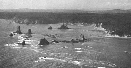 GIANTS GRAVEYARD, SOUTH OF LA PUSH, IS COMPOSED OF REMNANTS OF RESISTANT ROCKS THAT HAVE SURVIVED THE FORCES OF THE SEA. |
There are several trails leading to the beach. Starting at the north, the most important of these are the following:
INDIAN VILLAGE TRAIL, starting at Lake Ozette and extending 3 miles to the Ozette village site at the beach, leads through delightful forest and prairie. Much of the trail is a boardwalk made of split cedar puncheon.
SAND POINT TRAIL also starts at Lake Ozette and is 3 miles long. The distance between the Indian Village Trail and this trail is also 3 miles along the beach. Thus, a triangular 9-mile round trip is possible.
SECOND BEACH TRAIL is about one-half of a mile long.
THIRD BEACH TRAIL is about three-quarters of a mile long. These two latter trails start from the road near the village of La Push and lead to attractive, clean, sandy beaches.

|

|

| NPS History | History & Culture | National Park Service | Contact |
|
Last Modified: Sat, Nov 4 2006 10:00:00 pm PST |