|
NATIONAL PARK SERVICE
General Information Regarding National Capital Parks: Washington ca. 1933 |

|
PARKS IN THE CENTRAL AREA
The Mall
The L'Enfant plan included the unique feature of making the main central axis of the city, westward from the Capitol to the Potomac River, a great Mall parkway about 1,500 feet wide containing 256 acres. The White House is located at the north end of a similar park forming a cross axis which continues south to the Tidal Basin and the river, intersecting the Mall at the Washington Monument Grounds. The Mall was extended west of the latter late in the last century and reclaimed from the river's tidal flats to become West Potomac Park and the site of the Lincoln Memorial.
Today the Mall is one of the world's famous parkways and its development, in accordance with the plans of L'Enfant and of the McMillan Commission of 1901, has only just been begun. In an impressive plaza in the Mall, at the foot of the Capitol, Union Square is now being developed. Continuing to the west, between Seventh and Twelfth Streets, are the United States Army Medical Museum, the Smithsonian Institution, the Freer Art Galleries and the National Museum buildings. Along Constitution Avenue, bordering the Mall on the north, the new buildings of the "Government Triangle", housing the Departments of Commerce, Justice, and Labor, the Bureau of Internal Revenue and other Federal establishments, face the formal Parkway. The United States Department of Agriculture group is located on the south side of the Mall between Twelfth and Fourteenth Streets. West of Fourteenth Street is the Washington Monument.
The Washington Monument
The Washington Monument is to a high degree the symbol of the Capital City which George Washington founded and planned. The design originally selected included a Greek circular colonnade around the base of the obelisk, surmounted by a chariot with a colossal figure of Washington. Fortunately these extra adornments were omitted, and the proportions and form of the obelisk itself were changed to accord more nearly with the practice of the ancients.
Begun in 1848 by a committee which had been formed in 1833 under the chairmanship of Chief Justice John Marshall to collect voluntary subscriptions for the work, the monument was located on a natural mound close to the location planned by L'Enfant, at the intersection of the Mall axis with the park area running south from the White House. The work was stopped in 1854, because of lack of funds, when the shaft had reached a height of 152 feet.
In 1876 the Government undertook to complete the monument. The foundations, found to be entirely inadequate, were widened to 126 feet square and deepened to 37 feet below the surface before adding any weight. The shaft was carried to a total height of 555 feet 5-1/8 inches and completed in 1884 by Lieutenant-Colonel Thomas Lincoln Casey, officer in charge of Public Buildings and Grounds.
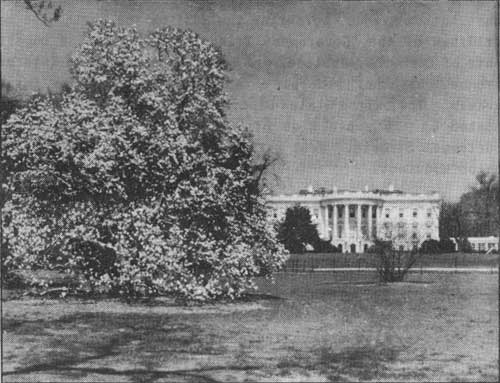
The White House in the inner portion of the President's Park
The President's Park is divided into the inner and outer portions, the inner portion including the 18 acres within the iron fence enclosing the Executive Mansion and grounds proper. The outer portion, also known as "Grounds South of the Executive Mansion" and the "White Lot", contains 52 acres and includes the Ellipse. It is bordered by Treasury Place, South Executive Avenue, State Place, 15th Street, 17th Street and Constitution Avenue.
This is one of the two parks included in the original L'Enfant Plan for the Federal City and is closely associated with the history of the National Capital and with the lives of the Presidents.
The Ellipse, bordered by stately American elms, provides playing fields for various sports and is one of the most intensively utilized recreation grounds of the park system.
The "Grounds South" provide a park setting for the south facades of the Treasury and State-War-Navy Buildings, the Commerce Building on the east; and the Corcoran Art Gallery, the American Red Cross Building, the National Headquarters of the National Society of the Daughters of the American Revolution and the Hall of the Americas, home of the Pan-American Union, on the west. It contains an equestrian statue of General Wm. T. Sherman, the Butt-Millet Memorial, the First Division American Expeditionary Forces Memorial, and the Zero Milestone.
The Lincoln Memorial
West of the Washington Monument, in the Mall, is the Lincoln Memorial Reflecting Pool and the National Memorial to the Great Emancipator. This is admittedly one of the finest memorials of modern times. The exterior of the memorial building symbolizes the Union of the States. Thirty-six columns of Indiana limestone form a colonnade representing the 36 States which existed at the time of Lincoln's death, the frieze above it bearing the names of the States. On the marble walls above the colonnade are the names of the 48 States of the Union as they exist today.
Inside these walls is a sanctuary containing three memorials to Abraham Lincoln. In the center is a colossal marble statue of the Emancipator, facing the Washington Monument and the Capitol. On the north wall is inscribed Lincoln's Second Inaugural Address and on the south wall, the Gettysburg speech. Above the inscriptions are two paintings on canvas, the painting on the north wall representing Reunion and Progress, and the painting on the south wall representing the Emancipation of a Race. Subordinate groups represent Civilization and Progress.
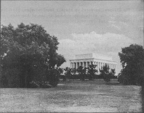
Lincoln Memorial — Dedicated in 1922
The Memorial was designed by Henry Bacon, Architect; the statue by Daniel Chester French, Sculptor; and the paintings are by Jules Guerin, The building is 201 feet 10 inches long, and 132 feet wide at the base; it is 79 feet 10 inches high from the top of the foundation to the attic. It is constructed of Colorado yule marble, pink Milford granite, Indiana limestone, and reinforced concrete. Construction was authorized by Congress on February 9, 1911 the cornerstone was laid on February 12, 1915, and the Memorial was dedicated on May 30, 1922. The cost was approximately $3,000,000.
To the east of the Memorial, extending toward the Washington Monument, lies a great reflecting pool in the still waters of which is reflected the Lincoln Memorial, at one end, and the Washington Monument, at the other. This pool is 1,992 feet long and 160 feet wide. It is bordered by two rows of stately English elms. At the eastern end of the main pool is an oval basin and fountain. This basin is 300 beet long by 160 feet wide. The fountain consists of 138 small jets about the side and in the center of the basin which throw the water in a spectacular rainbow effect.
West Potomac Park
Entering West Potomac Park at its western extremity is the memorial to John Ericsson, inventor of the screw propeller. Further to the east is the Tidal Basin, surrounded by the famous Japanese cherry trees—a focal point of interest during the season when these trees bloom and form a lacy fringe of rare beauty, usually in early April. The Japanese Cherry Trees, which were presented by the City of Tokyo during the Taft administration, have become a feature of especial beauty and interest. They were planted in 1912 by Viscountess Chinda, wife of the Japanese Ambassador, and Mrs. William Howard Taft. The pansy beds of West Potomac Park, containing more than 1,000,000 blooms, are also a major attraction during the spring months.
East Potomac Park
Entering East Potomac Park, 327 acres of land reclaimed through the dredging of the Washington Channel, one finds the Washington Rose Gardens, containing many interesting varieties and presenting a fragrant and colorful display many months of the year. Near by is the Washington tourist camp, screened from public view by careful planting. The "Speedway", a boulevard three and one-half miles long, borders East Potomac Park culminating in Hains Point at the confluence of the Potomac and Anacostia Rivers.
From Hains Point the visitor is afforded a sweeping view of the lower Potomac with the spires of historic Alexandria, Virginia, and the George Washington Masonic Memorial silhouetted against the southern horizon. To the east is Bolling Field, U. S. Army Aviation Post, and also the Anacostia Naval Air Station. Across the Washington Channel, on the north, is the U. S. Army War College. Returning westward, this drive affords glimpses of activities along the water front.
East Potomac Park is bordered by the double-blossom variety of Japanese cherry trees which bloom approximately two weeks after the single-blossom trees. These double blossoms possess a rare beauty and, though not so widely heralded as the Tidal Basin trees, are none-the-less one of Nature's loveliest exhibits in the Washington Parks.
The park is bordered by giant willows whose boughs bend over the seawalls, their foliage swaying gently in the soft breezes from the water.
Groups picnicking beneath the flowering cherry trees or in the cool shade of the willows, and golfers at play on the four public courses of the park are entertained by an endless parade of water craft and the maneuvers of airmen overhead.
Arlington Memorial Bridge
The Potomac Park highways skirt the Tidal Basin on the north, passing the John Paul Jones statue at the boot of Seventeenth Street and continuing to the Arlington Memorial Bridge, crossing the Potomac west of the Lincoln Memorial. The bridge, with the exception of the Bascule Draw Span, is of reinforced concrete construction, with all visible surfaces, except the soffits of the arches, faced with bush-hammered granite. The granite below the springing line of the arches is from the Stone Mountain Quarry in Georgia. All other granite is from the Mount Airy Quarry in North Carolina. It has an overall length of 2,163 feet and a clear width between balustrades of 90 feet; the width of the roadway between curbs is 60 feet, and the width of each of the two sidewalks 15 feet. It was dedicated in 1932, as a part of the great national bicentennial celebration of the birth of George Washington.
PARKS IN THE NORTHWEST SECTION
Rock Creek and Potomac Parkway
The northwest residential section of the City of Washington is divided from the District line to the Potomac River by the rough and picturesque valley of Rock Creek, splendidly forested and with all the charm of a mountain stream. The part of this valley south of National Zoological Park and connecting with West Potomac Park at the Lincoln Memorial, is known as the Rock Creek and Potomac Parkway.
Rock Creek Park
North of the National Zoological Park, administered by the Smithsonian Institution, is Rock Creek Park the largest recreational area of the capital park system. The Pierce Mill Waterfall, Milk House Ford, Bowlder Bridge, Joaquin Miller Cabin, and Ridge Road are principal features of interest. This park contains two nine-hole public golf courses, a group of 18 tennis courts, 19 picnic groves, and more than 30 miles of bridle paths.
The park treatment of the Rock Creek Valley has given the city of Washington one of the largest (nearly 1800 acres) and most unusual parks of any American city. The park has tremendous appeal to both residents of and visitors to the National Capital. Its slopes are covered with a great variety of wild flowers, and in the spring the tumbling stream and the park highways are fringed with the glistening pink and white blossoms of flowering dogwood. In the more secluded retreats a surprising wild life abounds.
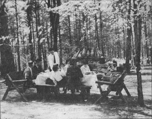
Picnic Grove in Rock Creek Park
The natural elements in Rook Creek Park serve as a cooling system that invariably keeps the temperature in the park 15 to 20 degrees below that of the city streets during the summer months. Hundreds of thousands of persons find relief from the exhaustive heat of midsummer by an evening visit to the cooling and refreshing reaches of the park.
The Act of September 27, 1890, authorizing the acquisition of the Rock Creek Valley for park purposes designated the area as "A pleasuring ground for the benefit and enjoyment of the people of the United States". This is the identical phraseology used by Congress in establishing Yellowstone National Park, the first national park ever created.
Fort Stevens Park
This sleeping fortress, located at 13th Street between Piney Branch Road and Rittenhouse Street, now a park of 2-1/2 acres, is dedicated to the gallantry of those who fought there in defense of the National Capital and to the memory of President Abraham Lincoln who risked the fire of enemy guns to stand upon its parapets and observe the progress of the attack.
This park now presents a scene of tranquility and repose in contrast to its urban surroundings, but about it was written one of the most important and exciting chapters of the Civil War.
Here a mixed assemblage of seasoned troops, "100-day men", convalescents, sailors, marines and civilians, under the command of General Horatio G. Wright, successfully halted the advance of General Jubal Early's Confederate Army of 20,000 battle-tried veterans and saved the Capital, and perhaps the Union, from a sudden and daring attack. The Federal and Confederate losses during the attack, on July 11 and 12, 1864, totalled nearly 900, killed and wounded.
During the firing at Fort Stevens on July 11, President Abraham Lincoln stood upon a parapet at the side of General Wright, observing the progress of the battle. A surgeon at his side was wounded. Lincoln took refuge behind the parapet, only at the repeated insistence of General Wright who felt the responsibility for his safety. This is the only occasion on which a President of the United States has been under fire of enemy guns while in office and a monument and tablet commemorating the event has been erected in Fort Stevens Park by the Sixth Army Corps Association.
A short distance north of Fort Stevens Park, on the east side of Georgia Avenue, between Van Buren and Whittier Streets, is Battleground National Cemetery, a single acre of land in which are buried 40 men who died during Early's attack.
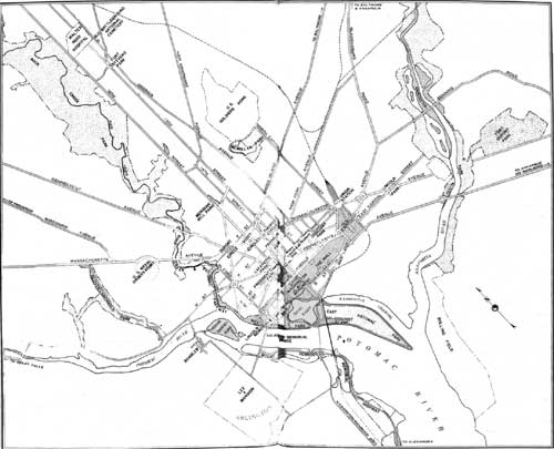 IMPORTANT PARK AREAS OF THE DISTRICT OF COLUMBIA (click on image for a PDF version) |
Meridian Hill Park
On Sixteenth Street south of Rock Creek Park between Euclid and W streets is Meridian Hill Park, a development of especial interest affording splendid panoramic views of the city. It was designed by Horace W. Peaslee, architect, and Ferruccio Vitale, landscape architect. It is in the style of an Italian garden with a high terrace overlooking the city and a great water cascade. It contains replicas of the Joan of Arc statue by Paul Dubois, and the Ximenes statue of Dante; also a monument to President Buchanan by Hans Schuler and La Serenity, a memorial to Lt. Commander William Henry Schuetz, U. S. Navy, by Jose Clara. The cascades which flow down the South Terrace of Meridian Hill Park are perhaps the most unusual architectural feature of the National Capital Parks.
Famous Circles
Dupont Circle, which is at the intersection of Connecticut and Massachusetts Avenues, contains a fountain by Daniel Chester French, dedicated to the memory of Admiral Samuel Francis Dupont. Some of the finest homes of the city face it on the east and north sides. Dupont Circle is a summertime rendezvous for small children who come with their mothers or nursemaids to play in the cool shade of its splendid trees.
East of Dupont Circle on Massachusetts Avenue, at the intersection with Sixteenth Street, is Scott Circle where statues memorialize General Winfield Scott, Daniel Webster, and Dr. Samuel Hahnemann.
Thomas Circle, two blocks east on Massachusetts Avenue at the intersection of Vermont Avenue, Fourteenth and M Streets, is dedicated to the memory of Major-General George H. Thomas.
Washington Circle, on Pennsylvania Avenue at 23rd Street, towards Georgetown, contains an excellent equestria statue of George Washington.
Lafayette Park
Lafayette Park, north of the White House, contains the Clark Mills' statue of Andrew Jackson (1853, probably the oldest equestrian statue cast in America), the statues of Lafayette by Alexander Falquier and Antonin Mercie; Rochambeau by F. Hamar; Von Steuben by Albert Jaegers; and Kosciuszko by Antoni Popiel. In this park are many interesting and unusual trees gathered from the far corners of the earth. The group includes a Japanese Pagoda tree and an English Purple Beech resplendent in its copper-hued foliage. Domestic trees also are well represented. The magnificent American elm, forming a border about the park, and the lovely southern magnolias attract much admiration.
Franklin Park
Franklin Park occupies a square block between I and K Streets and 13th and 14th Streets, northwest. A monument to Commodore Barry of the revolutionary Navy, by John F. Doyle, is at the west end. Opposite, at the east end on 13th Street, is the old Franklin School Building, which was awarded a prize at the Paris Exposition of 1878, and is now used as the administration building of the Board of Education. Surrounded by modern hotels, office buildings, and shops, this interesting park with its winding gravel walks, is reminiscent of the landscape architecture of the past generation. It contains more than 400 trees and shrubs, representing 76 distinct species, and contributes as interesting touch of nature to downtown Washington.
Judiciary Park
Judiciary Park provides a dignified setting for the District of Columbia Court House and the Old Pension Office. The central section of the Court House, originally built as a city hall, was designed by George Hadfield, and architecturally is still one of the most beautiful public buildings in the city. The park contains a statue of President Lincoln by the sculptor, Lot Flannery. It was unveiled on April 15, 1868, the first national memorial to be erected to the martyred President. There is also in this park a memorial fountain dedicated to the memory of Joseph J. Darlington, jurist and civic leader, and an equestrian statue of General San Martin, the Liberator. Judiciary Park is between E and F and Fourth and Fifth Streets.
PARKS IN NORTHEAST AND SOUTHEAST SECTIONS
Lincoln Park
Lincoln Park at 11th and East Capitol Streets, northeast, is noted for many of the oldest trees in Washington, and for Thomas Ball's statue of President Lincoln freeing the slaves, presented by Emancipated Citizens of the United States in 1876. In keeping with the spirit of this park dedicated to the memory of Lincoln, native species of trees and shrubs predominate over exotic varieties, two-thirds of the plants being of American origin. Among the native trees in this park is a group of large willow oaks, probably the finest to be found in any park in the world. The artistic approach to the Lincoln Statue is an excellent example of architectural design.
Anacostia Park
Anacostia Park, bordering the Anacostia River in southeast Washington and containing 277 acres, was developed through reclamation of the Anacostia flats. The area is devoted to recreational uses and there are an 18-hole golf course, 10 tennis courts, 4 baseball diamonds, 4 football fields, and also croquet and quoit courts. A feature of the park is the planting of flowering crab apple trees which border the driveway along the seawall between the Eleventh Street and Pennsylvania Avenue bridges. The young trees attract many visitors when they bloom in May and June. The trees remain in bloom from three to six weeks and give promise of becoming one of the major features of the National Capital Park system when they reach maturity. Another interesting feature is the National Memorial Grove, a group of trees from traditionally historical places. The main approach to this park is by way of the Pennsylvania Avenue Bridge across the Anacostia River.
| <<< Previous | Next >>> |
1933/sec2.htm
Last Updated: 30-Nov-2009