.gif)
A Study of the Park and Recreation Problem of the United States
MENU
Aspects of Recreational Planning
Present Public Outdoor Recreational Facilities
![]() A Park and Recreational Land Plan
A Park and Recreational Land Plan
|
A Study of the Park and Recreation Problem of the United States
|

|
A Park and Recreational Land Plan for the United States (continued)
ALABAMA
THE POPULATION, which is 64 percent white, is predominantly rural farm in character. It is evenly distributed over the State with the exception of the large concentration in Birmingham and its environs and a thinning out toward the Florida boundary. The majority of the Negro population is located in Birmingham and through the central part of the state from east to west. The economic conditions of a majority of the people are such as to preclude extensive travel for recreational purposes.
The outstanding recreational sections of the State are the mountain regions in the north and the Gulf shore in the south, neither of which are of such a character as to attract vacationists from beyond adjoining States, streams are generally too silted or polluted to be adapted to wide recreational use. The Gulf coast, while primarily a summer resort, has limited appeal to winter vacationists, The mountains, due to climatic conditions and scenery, offer fine opportunities for summer recreation.
The State has in the process of development a well-distributed system of areas for the white population, but additional facilities located near the people for day-use activities are needed. The largest amount of publicly owned acreage should be located near Birmingham and in the mountains. There is also a great need for State and local areas for Negro use. The greatest amount of acreage for this race should be near Birmingham and in the central part of the State. Additional Gulf frontage in public ownership is warranted. Attention should be given to clearing up streams in order to make them available for recreational use.
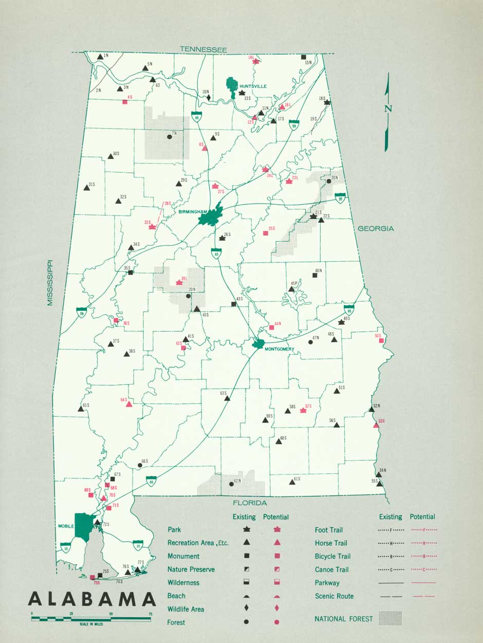
(click on image for an enlargement in a new window)
| FEDERAL | ||
| National forests: | Existing acreage |
Proposed additions |
| 26. Tombigbee purchase unit | 1,559 | |
| 39. Talladega | 325,571 | |
| 45. Black Warrior | 174,175 | |
| 62. Conecuh | 68,749 | |
| Total | 1570,054 | |
| National wildlife areas: | ||
| l. Petit Bois Bird Refuge | 523 | |
| 50. wheeler Migratory waterfowl Refuge | 41,800 | |
| Total | 42,323 | |
| National parkway: | ||
| 14. Natchez Trace (authorized) | 3,400 | |
| Recreational demonstration area: | ||
| 52. Oak Mountain | 7,805.19 | |
| Soil Conservation Service land utilization project: | ||
| 89. Tuskegee | 2355 | |
| Tennessee Valley Authority areas: | ||
| 15. Wilson Reservation | 50 | |
| 16. Muscle Shoals Park | 400 | |
| 17. Nitrate Plant Res. No. 2 | 70 | |
| 47. Wheeler Park | 1,100 | |
| Total | 1,620 | |
| STATE | ||
| State parks: | ||
| 3. Gulf (including Gulf-Morgan Parkway) | 4,522 | |
| 6. Cedar Creek | 660 | |
| 24. Chickasaw | 560 | |
| 29. Little River | 2,120 | |
| 38. Valley Creek | 1,080 | |
| 53. Oak Mountain | 940 | |
| 71. The Lagoons | 240 | |
| 73. Weogufka | 803 | |
| 79. Monte Sano | 2,111 | |
| 80. De Soto | 4,650 | |
| 82. Cheaha | 2,639 | |
| 86. Chewacla | 822 | |
| 94. Chattahoochee | 596 | |
| Total | 21,743 | |
| Proposed State parks: | ||
| 5. Mobile County | 400 | |
| 18. Dismals | ||
| 20. Tuscaloosa Area | 400 | |
| 27. Silver Creek Falls | ||
| 32. Big Tree | ||
| 36. Dallas County | 400 | |
| 42. Jefferson County | 1,600 | |
| 44. Clear Creek Falls | ||
| 48. Limestone County | 550 | |
| 49. Finley Island Bluff | 80 | |
| 51. Birmingham area | 800 | |
| 54. Turn Around | ||
| 57. Montgomery area | 500 | |
| 58. Montgomery County | 500 | |
| 77. Gadsden area | 200 | |
| 78. Guntersville | ||
| Total | 5,430 | |
| State monuments: | ||
| 22. Mound | 260 | |
| 72. Fort Toulouse | 7 | 70 |
| 74. Talladega | 421 | |
| 83. Horse Shoe Bend | 5 | |
| Total | 693 | 70 |
| Proposed State monuments: | ||
| 30. Fort Mims | ||
| 68. Pocosins | ||
| State forests: | ||
| 63. Panther Creek | 5,040 | |
| 66. Pea River | 331,327 | |
| Total | 36,367 | |
| LOCAL | ||
| Proposed local parks: | ||
| 4. Baldwin (1 area) | 40 | |
| 7. Washington County (1 area) | 40 | |
| 8. Choctaw (2 areas) | 120 | |
| 9. Sumter (1 area) | 100 | |
| 10. Greene (1 area) | 100 | |
| 11. Pickens (2 areas) | 120 | |
| 12. Lamar (1 area) | 80 | |
| 13. Marion (1 area) | 60 | |
| 19. Fayette (1 area) | 80 | |
| 21. Tuscaloosa (1 area) | 100 | |
| 23. Hale (2 areas) | 140 | |
| 25. Marengo (1 area) | 100 | |
| 28. Clarke (2 areas) | 120 | |
| 31. Escambia (1 area) | 40 | |
| 33. Conecuh (1 area) | 60 | |
| 34. Monroe (2 areas) | 160 | |
| 35. Wilcox (2 areas) | 140 | |
| 37. Perry (1 area) | 100 | |
| 40. Bibb (1 area) | 40 | |
| 41. Shelby (1 area) | 40 | |
| 43. Walker (1 area) | 40 | |
| 46. Lawrence (1 area) | 40 | |
| 55. Elmore (1 area) | 60 | |
| 56. Autauga (1 area) | 60 | |
| 59. Lowndes (2 areas) | 140 | |
| 60. Butler (2 areas) | 160 | |
| 61. Covington (1 area) | 40 | |
| 64. Coffee (1 area) | 40 | |
| 65. Dale (1 area) | 40 | |
| 67. Crenshaw (2 areas) | 100 | |
| 69. Pike (1 area) | 60 | |
| 70. Bullock (2 areas) | 140 | |
| 75. Talladega (1 area) | 100 | |
| 76. Etowah (1 area) | 40 | |
| 81. Calhoun (1 area) | 60 | |
| 84. Chambers (1 area) | 100 | |
| 85. Talapoosa (1 area) | 40 | |
| 87. Lee (1 area) | 100 | |
| 90. Russell (2 areas) | 140 | |
| 91. Barbour (2 areas) | 100 | |
| 92. Henry (2 areas) | 120 | |
| 93. Houston (1 area) | 60 | |
| Total | 43,560 | |
| Municipal parks: | ||
| 95. Mobile (1 area) | 267 | |
| 96. Montgomery (2 areas) | 280 | |
| 97. Birmingham (2 areas) | 314 | |
| Total | 861 | |
1 Area under Federal administration June 1938.
2 Acreage being developed for recreation, portion of large project.
3 Soil Conservation Service area transferred to State Division of Forestry for administration.
4 16 parks (980 acres) for whites; 38 parks (2,580 acres) for Negroes.
NEXT >>>
 Top
Top
Last Modified: Mon, Aug 9 2004 10:00:00 pm PDT
http://www.cr.nps.gov/history/online_books/park_recreation/alabama.htm
![]()